 Block
From the record
6 National Register listings published here.
Sources: the National Register database, National Park Service
19 topographic sheets cover 6 settlements here, and 6 properties are on the National Register of Historic Places.
6 National Register listings published here.
Sources: the National Register database, National Park Service
Every property in this county listed on the National Register of Historic Places, with the year it was listed and the federal nomination document.
| Photograph | Property | Type | Listed | Reference |
|---|---|---|---|---|
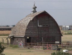 | Beamer Barn | building | 2010 | 10000452 |
 | Benson Culvert | structure | 2013 | 13000878 |
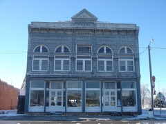 | Grainfield Opera House | building | 1980 | 80001467 |
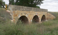 | Jenkins Culvert | structure | 2013 | 13000879 |
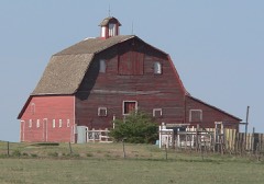 | Oxley Barn | building | 2008 | 08000303 |
Every wildfire the federal occurrence database records inside this county: 13 of them, burning about 4,407 acres. None started naturally and none was recorded as arson. Each settlement page carries the fires within five miles of it.
| Reported cause | Fires |
|---|---|
| Missing data/not specified/undetermined | 7 |
| Smoking | 2 |
| Debris and open burning | 2 |
| Equipment and vehicle use | 2 |
The five largest, by the area the report gives. None of them was recorded as arson.
| Date | Cause | Size | Reported by | Name on the report |
|---|---|---|---|---|
| 15 February 2017 | Missing data/not specified/undetermined | 1,900 acres | Gove County | BREACH |
| 12 March 2008 | Missing data/not specified/undetermined | 1,600 acres | Kansas Counties | GOVE EAST |
| 12 March 2008 | Missing data/not specified/undetermined | 500 acres | Kansas Counties | GOVE WEST |
| 21 September 2020 | Equipment and vehicle use | 160 acres | Kansas Forest Service | not named |
| 11 June 2020 | Missing data/not specified/undetermined | 90 acres | Kansas Forest Service | not named |
| 16 March 2015 | Smoking | 45 acres | Kansas Forest Service | 4 |
| 20 March 2017 | Smoking | 40 acres | Lane County | 446 |
| 7 April 2020 | Equipment and vehicle use | 40 acres | Kansas Forest Service | not named |
Every settlement page carries the fires within five miles of it - see the settlement index below.
The NOAA Storm Events Database holds 754 reports for this county, causing no deaths, 3 injuries and about $11,125,680 in recorded property damage. Each settlement page carries the reports that name it.
| Kind of event | Reports |
|---|---|
| Hail | 447 |
| Thunderstorm Wind | 200 |
| Tornado | 62 |
| Flash Flood | 30 |
| Flood | 9 |
| Funnel Cloud | 3 |
| Lightning | 2 |
| Heavy Rain | 1 |
The most serious of them, by death, then injury, then recorded damage. The accounts are quoted exactly as the forecast office filed them.
| When | Event | Place named | Harm | What the report says |
|---|---|---|---|---|
| May 2008 | Tornado (EF4) | Quinter | 2 hurt, $2,500,000 | A large wedge tornado developed about 9 miles SSW of Quinter and moved north, then northwest, eventually dissipating 2 miles SE of Park. This tornado caused extensive damage to several homes, including EF4 damage to one home which was completely destroyed. A car and a pickup truck were tossed or bounced 200 yards at the residence. Nearby, two other homes suffered extensive damage. This tornado caused two injuries, including the driver of a vehicle which was thrown off Interstate 70, and an older male attempting to get into his storm cellar when he was struck by flying debris. |
| May 1964 | Tornado (F1) | not stated | 1 hurt, $25,000 | no account filed |
| May 1995 | Hail | Grainfield | $2,500,000 | One and one-half inch hail also at Grainfield 1335 CST. The hail combined with winds damaged 60 farm structures and KANSAS, Northwestern Cont'd |
| May 1995 | Hail | Gove | $2,500,000 | Hail and high winds damaged 25,000 acres of wheat and 30 farm structures. |
| May 2008 | Tornado (EF0) | Quinter | $750,000 | Storm chaser videotaped a large wedge tornado just north of Quinter, which moved into Sheridan county along a path just west of a second tornado occurring simultaneously. This tornado caused extensive utility pole damage from northern Gove into southern Sheridan county, and impacted several homesteads with roof and outbuilding damage. |
| September 2001 | Hail | Park | $480,000 | Large hail and wind damaged buildings in and around Park. Windows were broken, crops were destroyed, and hail was 4 to 6 inches deep in places. Hail completely covered Interstate 70 until snow plows cleared the highway. |
| October 2021 | Thunderstorm Wind | Campus | $285,000 | Emergency Manager relayed that 1/2 mile of power poles were blown down due to straight line winds that resulted in no power for the city of Oakley. |
| August 1996 | Thunderstorm Wind | Quinter | $250,000 | no account filed |
| August 1979 | Tornado (F2) | not stated | $250,000 | no account filed |
| August 1950 | Tornado (F2) | not stated | $250,000 | no account filed |
| May 2008 | Hail | Park | $150,000 | About a dozen reports of large, damaging hail were received from the NSSL SHAVE project. Windows were broken, and some roof damage occurred. Hail was embedded 1-2 inches into the ground in some locations. The hail occurred with a supercell thunderstorms tracking north through the area. |
| May 2008 | Tornado (EF1) | Gove | $150,000 | A tornado moved across rural eastern Gove county during the late afternoon and produced EF1 damage at a home on Road O before dissipating. Severe roof damage occurred and several outbuildings were damaged or destroyed. |
| September 2023 | Thunderstorm Wind | Park | $100,000 | Kansas Highway Patrol reported three semi trucks rolled over due to thunderstorm wind gusts estimated to be 70 mph. The semi trucks were blown over between mile markers 99 and 104 on I-70. |
| October 2017 | Tornado (EF1) | Quinter | $75,000 | Many structures were damaged in Quinter. The tornado began near the elementary school, causing damage to play ground equipment and blew a fence down. The tornado then caused damage to the city building to the northeast of the school, and damaged a few businesses, a few single-wide mobile homes, and a few homes. Damage to the buildings ranged from loosing shingles to porches being blown over, blowing in a set of doors to a hardware store, and blowing a mobile home off its foundation. Many windows were also broken out of the buildings and a few vehicles. Some of the buildings with metal roofing lost some paneling. Numerous trees had significant damage, with some tree trunks having been snapped. A windbreak on the edge of town was damaged in the middle but not on either end. |
| July 1999 | Flash Flood | Quinter | $75,000 | Numerous reports of flash flooding in vicinity of Quinter. Several houses suffered flood damage in basements. |
| August 2024 | Thunderstorm Wind | Quinter | $70,000 | Report relayed of damage to two tin sheds that had part of the roofs torn off, a metal fence blown over, and some power lines were broken. Time is estimated from a nearby mesonet report. |
| June 2015 | Thunderstorm Wind | Park | $59,000 | A semi pulling a loaded trailer and a truck pulling a camper were blown over at mile marker 99 near the Park exit. The driver of the semi received injuries from the accident. |
| May 2015 | Tornado (EF1) | Grinnell | $50,000 | Spotters repported a tornado moving from south of Grinnell to just northwest of Grinnell. Minor roof damage was reported and irrigation pivot sections were overturned. |
| June 2014 | Tornado (EF1) | Gove | $50,000 | Time estimated from Doppler radar. Two outbuildings heavily damaged and one nearly destroyed. Three hail bales moved. Residence itself sustained minor to no damage. |
| May 2010 | Thunderstorm Wind | Gove | $50,000 | Farm business received damage to several grain bins from the rear flank downdraft of a supercell just south of a large tornado. Time of report is estimated from Doppler radar. |
| October 2017 | Tornado (EF1) | Gove | $40,000 | A brief tornado crossed CR I between CR 38 and CR 42. Several large trees were snapped in a creek bottom. A few farm structures suffered significant damage to their roofs. One or two windows were also broken in one of the structures. Some of the metal roofing from one of the structures was blown into a field northeast of the farm property. Many limbs and a few tree trunks were snapped on the property too. |
| June 2003 | Thunderstorm Wind | Park | $39,600 | Seven towers of irrigation system blown over by strong thunderstorm winds. Center pivot still standing. |
| May 2010 | Hail | Quinter | $30,000 | Newspaper reported extensive damage to a home as a result of hail and strong winds associated with a tornado-producing supercell. |
| June 2020 | Flash Flood | Grinnell | $25,000 | Gove County Dispatch reported approximately 10 inches of water under the I-70 overpass at mile marker 86. A vehicle was reported to be stuck in the water. Flash flooding occurred due to training of cells within a line moving NE and then the line pushed east out of the area around an hour later. Damage costs to the vehicle are unknown. |
| May 2010 | Tornado (EF1) | Gove | $25,000 | A center pivot was overturned near Road K and Road 64. |
| May 2010 | Thunderstorm Wind | Gove | $25,000 | A quonset building lost its roof in thunderstorm outflow. This outflow appears to be associated with a strong rear flank downdraft on the south end of a tornado-producing supercell. |
| May 2008 | Tornado (EF1) | Quinter | $25,000 | KAKE-TV relayed this tornado report. This tornado damaged utility poles and trees as it moved northeast from Gove into southern Sheridan county. |
| May 2008 | Tornado (EF0) | Grainfield | $25,000 | This tornado developed 3 miles SW of Grainfield and moved north 11 miles into Sheridan county, dissipating 9 miles SW of Hoxie. This tornado remained over open fields. |
| September 2008 | Flood | Quinter | $24,000 | Castle Rock Road and surrounding county roads south of Quinter were closed due to high water in Big Creek resulting from extremely heavy rainfall. The heaviest precipitation occurred the previous evening across northern Gove county further upstream in the Grainfield and Park areas. County officials reported many road washouts and several damaged culverts. |
| May 2010 | Tornado (EF1) | Gove | $22,500 | The tornado was described as very large. Approximately 15 power poles were damaged on Road L associated with this tornado. |
| September 2008 | Flash Flood | Grainfield | $20,000 | A series of thunderstorms moved across northern Gove county during the afternoon and evening hours. One cooperative observer recorded 6.61 inches of rain just west of Park by 1125 pm CDT , and an unofficial rainfall report of 10.60 inches was noted 3 miles east-southeast of Grainfield from a Gove county road department employee. Area roads were flooded and ditches were full of water. At least two people had to be rescued when their car went into a flooded ditch and stalled. |
| August 2018 | Thunderstorm Wind | Quinter | $17,000 | Tree uprooted and roof blown off a house. Animal pen and other structural material blown against a chain link fence enclosure. |
| May 2008 | Thunderstorm Wind | Grainfield | $15,000 | A semi-trailer was blown over on Interstate 70. Time of this report is estimated. |
| August 2024 | Thunderstorm Wind | Quinter | $12,000 | Semi tipped over on Interstate 70 at mile marker 110-111. The semi was travelling east and blown to the north. |
| October 2021 | Thunderstorm Wind | Campus | $12,000 | Strong winds associated with a line of thunderstorms blew over a semi truck traveling east bound on Interstate 70 near Oakley. The interstate was closed briefly to allow crews to remove the truck. |
| July 2024 | Thunderstorm Wind | Gove | $10,000 | Numerous healthy cottonwood, elm, and cedar trees down on the property. All were healthy. Peak winds occurred around 4 pm CDT. Location also received 4.2 inches of rain. |
| August 2018 | Thunderstorm Wind | Gove | $10,000 | Straight-line winds from a thunderstorm uprooted entire trees, and broke large branches from other trees. A south facing window was also broken. The winds peeled off a metal roof of a shed, and damaged a glass greenhouse as well as the plants in it. |
| June 2017 | Flood | Grainfield | $10,000 | Intense, heavy rainfall caused many drivers to hydroplane and a semi with trailer to rollover at mile marker 91 on I-70, two miles west of Grainfield. |
| August 2014 | Thunderstorm Wind | Grinnell | $10,000 | A semi was blown off Interstate 70 near mile marker 86 near Grinnell. |
| July 2011 | Thunderstorm Wind | Campus | $10,000 | A semi was blown off Interstate 70 at this location. Firefighters on scene estimated peak wind gusts of between 60 and 70 mph. 1.70 inches of rainfall was also measured. |
| May 2008 | Hail | Grinnell | $10,000 | NSSL SHAVE project relayed 6-8 reports of large hail from 4 SW Grinnel north to Grinnell. Some windows and screens were broken and cars were dented and had broken windshields. |
| June 1998 | Thunderstorm Wind | Gove | $10,000 | Windows blown out of tractor. Large grain bin blown over. |
| May 1998 | Hail | Gove | $10,000 | Destroyed satellite dish and numerous windows and crops |
| May 2010 | Heavy Rain | Quinter | $9,000 | Twelve calves were drown when they apparently fell into fast running water from heavy rainfall. |
| December 2016 | Thunderstorm Wind | Grinnell | $8,000 | Thunderstorm wind gusts blew a porch down and blew out car windows in town. |
| June 2014 | Thunderstorm Wind | Gove | $6,000 | Thunderstorm outflow brought down six power poles. |
| May 2010 | Thunderstorm Wind | Campus | $6,000 | Thunderstorm wind gusts damaged 6 power poles, with all poles laying down in the same direction. |
| September 2015 | Thunderstorm Wind | Campus | $5,000 | A power pole was snapped on old Highway 40 from the high winds. |
| May 1998 | Hail | Gove | $5,000 | Broken windows |
| June 1998 | Thunderstorm Wind | Gove | $5,000 | Power pole and power lines downed. |
| June 2014 | Thunderstorm Wind | Gove | $4,500 | Sunflower Electric double wooden utility poles are either leaning or damaged in this area. Time of damage estimated from Doppler radar. |
| October 2017 | Tornado (EF0) | Gove | $4,000 | An old shed collapsed due to walls giving way and an enclosed trailer was blown over. Several small limbs were snapped and a single pole for a residential cell tower was blown over. |
| May 2016 | Hail | Park | $4,000 | The hail broke windows in the house. |
| April 1990 | Tornado (F0) | not stated | $2,500 | no account filed |
| July 2021 | Thunderstorm Wind | Park | $1,000 | Caller reported a full grown evergreen tree was uprooted as a strong supercell moved over the location. |
| July 2020 | Hail | Campus | $1,000 | Emergency Manager reported hail ranging from quarters to golf ball in size covering the ground enough to appear white. At a nearby residence, hail ranging from quarters to golf ball in size broke several windows. |
| May 2017 | Thunderstorm Wind | Quinter | $1,000 | A power line was blown down in town. |
| August 2017 | Thunderstorm Wind | Quinter | $1,000 | A large tree was split in two. |
| July 2013 | Thunderstorm Wind | Campus | $1,000 | Late report of six-eight inch diameter live tree limbs blown down. A small shed was also destroyed by strong thunderstorm outflow. An empty stock tank was blown approximately one mile and came to rest in a corn field. Time of report estimated from Doppler radar. |
| July 2011 | Thunderstorm Wind | Park | $1,000 | A power pole broke at the ground as a result of thunderstorm winds. |
Named settlements recorded in the Geographic Names Information System, each with the topographic sheets covering it. Villages, hamlets and abandoned places alike. Each is shown with the nearest named watercourse or landform and the survey quadrangle it falls on.