 Block
From the record
11 National Register listings published here, 1 of them a National Historic Landmark.
Sources: the National Register database, National Park Service
51 topographic sheets cover 30 settlements here, and 11 properties are on the National Register of Historic Places.
11 National Register listings published here, 1 of them a National Historic Landmark.
Sources: the National Register database, National Park Service
Every property in this county listed on the National Register of Historic Places, with the year it was listed and the federal nomination document.
| Photograph | Property | Type | Listed | Reference |
|---|---|---|---|---|
| Stuart Dunlap House | building | 1992 | 92000587 | |
 | German Evangelical St. Johns Church-Deutsche Evangelische St. Johannes Kirche | building | 2001 | 00001642 |
 | Hotel Brown | building | 2014 | 14000335 |
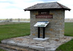 | Huff State Historic Site (32MO11) | site | 1980 | 80002920 |
 | Lewis and Clark Hotel | building | 1983 | 83001938 |
 | Mandan Commercial Historic District | district | 1985 | 85000341 |
| Mandan High School | building | 2017 | 100001364 | |
 | Louis Rehm Barn | building | 1994 | 93001550 |
| State Training School Historic District | district | 1996 | 95001549 | |
| Sunnyside Farm Barn | building | 1996 | 95001550 | |
| Welsh House | building | 1980 | 80002921 |
Every wildfire the federal occurrence database records inside this county: 134 of them, burning about 2,156 acres. 13 started naturally and 1 was recorded as arson. Each settlement page carries the fires within five miles of it.
| Reported cause | Fires |
|---|---|
| Equipment and vehicle use | 49 |
| Missing data/not specified/undetermined | 27 |
| Natural | 13 |
| Debris and open burning | 13 |
| Fireworks | 12 |
| Smoking | 7 |
| Power generation/transmission/distribution | 6 |
| Recreation and ceremony | 5 |
| Arson/incendiarism | 1 |
| Misuse of fire by a minor | 1 |
The five largest, by the area the report gives. None of them was recorded as arson.
| Date | Cause | Size | Reported by | Name on the report |
|---|---|---|---|---|
| 15 August 2015 | Equipment and vehicle use | 600 acres | North Dakota State Forest Service | SWEETBRIAR FIRE |
| 23 August 2003 | Natural | 400 acres | North Dakota State Forest Service | MORTON COUNTY |
| 2 September 2020 | Debris and open burning | 200 acres | North Dakota State Forest Service | FD2009020007 |
| 27 June 2006 | Missing data/not specified/undetermined | 150 acres | North Dakota State Forest Service | LITTLE HEART BOTTOMS |
| 9 July 2017 | Equipment and vehicle use | 100 acres | North Dakota State Forest Service | MH FIRE |
| 4 April 2012 | Missing data/not specified/undetermined | 90 acres | North Dakota State Forest Service | RAYMOND KAELBERER |
| 18 July 2017 | Natural | 60 acres | North Dakota State Forest Service | CANNONBALL RANCH 2017-054 |
| 28 July 2017 | Missing data/not specified/undetermined | 50 acres | North Dakota State Forest Service | WO ROAD |
Every settlement page carries the fires within five miles of it - see the settlement index below.
The NOAA Storm Events Database holds 805 reports for this county, causing 3 deaths, 25 injuries and about $142,967,530 in recorded property damage. Each settlement page carries the reports that name it.
| Kind of event | Reports |
|---|---|
| Hail | 420 |
| Thunderstorm Wind | 294 |
| Tornado | 54 |
| Funnel Cloud | 13 |
| Flood | 11 |
| Flash Flood | 9 |
| Lightning | 2 |
| Heavy Rain | 2 |
The most serious of them, by death, then injury, then recorded damage. The accounts are quoted exactly as the forecast office filed them.
| When | Event | Place named | Harm | What the report says |
|---|---|---|---|---|
| May 1953 | Tornado (F5) | not stated | 2 killed, 20 hurt, $250,000 | no account filed |
| June 1999 | Thunderstorm Wind | Mandan | 1 killed, $2,000,000 | One man killed while attempting to land small plane at the Mandan airport. Extensive damage occurred to building roofs and large trees were damage or destroyed. Widespread electrical outage. |
| May 1993 | Thunderstorm Wind | Mandan | 3 hurt, $50,000 | Winds overturned two tractor semi-trailers on Interstate 94 west of Mandan. Three occupants inside were injured. |
| April 2010 | Thunderstorm Wind | Mandan | 1 hurt, $25,000 | High winds from thunderstorms caused a large tree to fall on a mobile home in Mandan. One person in the home received minor injuries. Time is estimated. |
| August 2014 | Lightning | New Salem | 1 hurt, $3,000 | A vehicle, traveling north on North Dakota Highway 31 north of New Salem, was struck by lightning. Airbags in the vehicle deployed. A female passenger in the front right seat of the vehicle suffered injuries and was taken to a hospital by ambulance. The vehicle sustained cosmetic damage and all electronics were inoperable. The vehicle was disabled. |
| June 2001 | Hail | Mandan | $113,000,000 | no account filed |
| June 2011 | Flood | New Salem | $10,000,000 | See the event episode narrative for details. |
| June 2009 | Flash Flood | Mandan | $1,800,000 | Thunderstorms with heavy rainfall continuously redeveloped across far eastern Morton County for several hours during the evening of the 15th. Public reports of three to four inches of rainfall were received in the city of Mandan along with street flooding. Some homes had water in their basements. A 30 foot by 40 foot section of roof collapsed at a bowling alley in Mandan. Newspaper reports were that the flat roof failed as a result of the added stress from the weight of the rain water. Two elementary schools in Mandan also had water damage. There were no injuries or deaths. |
| June 2025 | Tornado (EF2) | New Salem | $1,500,000 | This Quasi-Linear Convective System (QLCS) tornado occurred to the north-northwest of Sweet Briar Lake. Three farmsteads were impacted. The first farmstead had minimal damage. The second farmstead had two large pole barns lose their roofs, with some collapsed walls. A half-full steel grain bin had its top completely removed, with the bin side dented in to grain level. A large Harvestore silo was significantly dented. A mile of power poles were broken between the second and third farms. The third farm had damage to the house which included much of the shingling being removed and a portion of the roof sheathing being removed, along with windows being broken. In addition, a pole barn had almost all its roof covering blown off with mainly rafters remaining. After the third farm, the tornado then struck a wind turbine, which snapped its support pole 1/4 of the way up, resulting the turbine toppling. Another turbine suffered blade damage. Based on the damage done this tornado was rated EF-2, and from that wind speeds were estimated to be around 120 mph. |
| May 2010 | Thunderstorm Wind | New Salem | $1,300,000 | A large fertilizer building north of New Salem sustained heavy damage from extreme straight line winds associated with a severe thunderstorm. Visual inspection of the damage conducted during a storm survey indicates estimated winds of 95 mph. Much of the damage was to the roof of the building, in which much of the metal roof was peeled back and blown off to the north. Preliminary damage was estimated at over one million dollars to the building and loss of fertilizer.||Additional damage from severe thunderstorm winds was observed north-northeast of New Salem towards the Morton County and Oliver County border. Several farms had damage to outbuildings, trees, and farm equipment. Damage here was estimated at one quarter of a million dollars. |
| May 1996 | Thunderstorm Wind | Mandan | $1,300,000 | no account filed |
| May 2023 | Hail | Sweet Briar | $1,000,000 | A supercell thunderstorm produced golf ball size hail near Crown Butte Lake, and then moved through the Mandan area continuing to produce golf ball size hail. Multiple vehicles were dented and roofs damaged. The storm then continued into Bismarck in Burleigh County. |
| March 2009 | Flood | Mandan | $603,000 | Heavy overland flooding from the Heart River damaged state, county, and township roads. Eleven homes were flooded. Ice jams on the Heart contributed to flood severity. The Cannonball River also contributed to overland flooding along the Sioux County line. Flooding continued into April. |
| June 1999 | Thunderstorm Wind | St Anthony | $500,000 | Cumpled six power lines |
| May 1998 | Tornado (F1) | Glen Ullin | $500,000 | The tornado damage was confined to the west side of town while downburst winds and hail affected the east side. Several buildings at the airport and golf coarse were destroyed as well as garages and grain bins. Numerous trees and power lines were downed. The first severe weather outbreak of the season saw numerous funnel cloud, tornado and hail reports. Thunderstorms developed late in the afternoon along a warm front which extended from Dickinson to Devils Lake. Most of the storms moved northeast and produced heavy rain and pea size hail. Those storms that moved east produced the severe weather. |
| August 2024 | Thunderstorm Wind | St Anthony | $450,000 | Thunderstorm wind combined with hail to cause significant damage to structures in St. Anthony. Homes had multiple windows completely broken out and siding was severely damaged with holes punched completely through. |
| April 2023 | Flood | Hebron | $450,000 | Flooding from snow melt runoff caused significant damages to county infrastructure, which includes damage caused by an ice jam in Mandan along the Heart River. |
| August 2021 | Hail | Flasher | $400,000 | Very large hail combined with wind gusts to cause extensive damage. At one farmstead, all windows were broken out of the north side of two homes. Steel siding was dented on one home, and vinyl siding was destroyed on the other. Five vehicles had their windows broken. Crops were flattened and trees were stripped of leaves. Other farmsteads in the area also had broken windows in their homes, and destroyed crops. |
| July 2024 | Hail | Mandan | $300,000 | An intense thunderstorm passed over the Harmon Lake area, including the campgrounds on the north side, and produced hail as large as three inches in diameter. Many campers and structures sustained significant damage. |
| July 2017 | Hail | Mandan | $250,000 | Large hail fell over a broad swath of the city of Mandan, with the largest hail reported near the baseball field on 3rd Street SW. |
| June 2016 | Hail | Hebron | $250,000 | The hail combined with gusty winds to cause damage to the windows, siding, and roofs of homes in Hebron. |
| July 2014 | Thunderstorm Wind | New Salem | $250,000 | New wind turbine blades stored on the ground and waiting to be installed were completely destroyed. |
| June 2007 | Flood | St Anthony | $250,000 | In the area around St. Anthony the Morton County Emergency Manager reported water running over roads and minor damage to some bridges. |
| August 2016 | Hail | Mandan | $250,000 | no account filed |
| June 1986 | Tornado (F0) | not stated | $250,000 | no account filed |
| July 1981 | Tornado (F3) | not stated | $250,000 | no account filed |
| May 1978 | Tornado (F3) | not stated | $250,000 | no account filed |
| August 2021 | Hail | Judson | $200,000 | Multiple homes in the area were heavily damaged, which included broken windows and destroyed siding. In addition, a few campers were also damaged. |
| July 2018 | Thunderstorm Wind | Ft Rice | $200,000 | Several garages were ripped from foundations in the Fort Rice area. An unoccupied mobile home was blown down a hill, and a travel trailer recreational vehicle was blown into the Missouri River. |
| June 2016 | Thunderstorm Wind | Hebron | $200,000 | High winds knocked over grain bins, 18-inch diameter trees, and power lines south of Hebron. The winds combined with hail to cause damage to homes. |
| June 2010 | Tornado (EF1) | Mandan Muni Arpt | $200,000 | Grain bins were destroyed by this tornado and there was some crop damage. Based on information received from the property owner about the damage, it was determined that this tornado was a middle EF1 on the Enhanced Fujita Scale. From that it was determined that wind speeds were around 95 mph. |
| May 2008 | Tornado (EF1) | New Salem | $200,000 | The tornado was originally reported by Morton County law enforcement. A storm damage survey was conducted by the National Weather Service and found that damage occurred to five farms in the New Salem area. Damage to farm houses was minor. Damage to farm outbuildings was significant with roofs torn off and smaller buildings destroyed. In some cases small outbuildings were destroyed while others nearby had little in any damage. Horse trailers were pushed and some were tipped. Tree trunks were snapped part way up their bases. The tornado damage corresponded to EF1 on the Enhanced Fujita Scale. From that it was determined that wind speeds in the tornado were on the order of 100 mph. This was the first of two tornadoes in Morton County this evening. |
| July 2001 | Flood | Mandan | $200,000 | Up to 5 inches of rain fell within a 24 hour period causing flooded roads. High water washed up debris over some rural roads and homes. Up to 4 feet of standing water on some roads in the city. |
| August 2016 | Hail | Mandan | $200,000 | no account filed |
| August 2016 | Hail | Mandan | $200,000 | no account filed |
| April 2009 | Flood | Mandan | $190,000 | Heavy overland flooding and flooding on the Heart River from snowmelt damaged numerous state, county, and local roads along with eleven homes. |
| July 2023 | Thunderstorm Wind | Breien | $150,000 | A roof was torn off a barn and a window was blown into the house. A metal horse cultivator was tossed, and fresh hay bales were rolled. |
| June 2020 | Thunderstorm Wind | Flasher | $150,000 | A home sustained substantial damage due to straight line winds. Approximately one-half of the roofing on the west side of the home blew off, with much of the remaining metal roof covering on the west side also being blown off. An attached permanent front porch awning on the west side, a wheel barrow, and multiple children's toys were also blown away. The debris blew towards the east-northeast. |
| July 2018 | Thunderstorm Wind | Almont | $150,000 | A large well-constructed pole barn was destroyed with multiple pieces of farm equipment inside. |
| June 2016 | Thunderstorm Wind | Almont | $150,000 | Many trees were reported down in the town of Almont. Some trees fell onto cars and campers. Also, some buildings were struck by falling trees. |
| July 2014 | Thunderstorm Wind | New Salem | $150,000 | Strong thunderstorm winds resulted in tree and building damage in and around the New Salem area. |
| June 2010 | Flash Flood | Glen Ullin | $150,000 | Up to six inches of rain fell across portions of western and central Morton County. The heavy rainfall resulted in numerous flooded roadways and flooded basements. Road damage was reported to be extensive in some locations. |
| August 2010 | Thunderstorm Wind | New Salem | $150,000 | Large hail accompanied the strong thunderstorm winds. The wind driven hail and strong winds resulted in widespread damage in the town of New Salem. Several trees were uprooted, and hail damage was sustained to homes and vehicles. |
| August 2016 | Hail | Mandan | $150,000 | no account filed |
| August 2024 | Hail | St Anthony | $125,000 | Mainly baseball size hail fell at this location, but one hailstone was measured at 4 inches in diameter. Significant damage occurred to roofs of buildings and to vehicles. |
| May 2019 | Hail | St Anthony | $120,000 | Siding was damaged in St. Anthony. |
| July 2023 | Thunderstorm Wind | Breien | $100,000 | The thunderstorm winds combined with hail to flatten two-thirds of a wheat field and to severely damage a sunflower field. |
| June 2021 | Thunderstorm Wind | Glen Ullin | $100,000 | Damage occurred in and around the city of Glen Ullin. About a mile west of town, outbuildings were severely damaged, and a roof on an industrial building was damaged. In town, A five inch diameter tree was broken over. |
| July 2014 | Thunderstorm Wind | Huff | $100,000 | Large hail accompanied the strong thunderstorm winds with damage to structures and crops. |
| July 2008 | Hail | Hebron | $100,000 | Hail up to the size of ping pong balls fell in the city of Hebron, causing damage to buildings and vehicles. |
| July 2013 | Tornado (EF0) | Judson | $95,000 | A tornado briefly touched down five miles north of Judson. Local emergency management reported the tornado damaged or destroyed three barns, and destroyed two grain bins on a farmstead. The damage reported corresponded to an EF0 on the Enhanced Fujita Scale. From that it was determined that wind speeds were on the order of 80 miles per hour. |
| May 2010 | Thunderstorm Wind | Almont | $80,000 | Strong straight line winds associated with a severe thunderstorm tore the roof off of a farm outbuilding, broke off tree branches, blew down a small wind turbine, and pushed a large old barn so that it now leans towards the north. Wind speed was estimated from the visual inspection of damage during a storm survey. |
| June 2025 | Thunderstorm Wind | New Salem | $75,000 | A large tree snapped towards the base, and another tree fell onto a house. |
| August 2011 | Thunderstorm Wind | Sims | $65,000 | Straight line wind damage occurred near New Salem. A barn roof was destroyed, an auger was tipped over, and debris was thrown into the side of a home. |
| June 2018 | Thunderstorm Wind | Hebron | $55,000 | A semi-truck flipped over on Interstate 94. |
| June 2025 | Thunderstorm Wind | Almont | $50,000 | Multiple power lines were blown down. |
| September 2025 | Flash Flood | Mandan | $50,000 | Approximately two to three inches of rain fell in a short period of time, leading to flash flooding. Many rural roads over far eastern Morton County had water flowing over. |
| August 2021 | Thunderstorm Wind | Flasher | $50,000 | A semi-truck and trailer were blown over by thunderstorm winds. The very strong winds continued for a few minutes after the truck blew over. |
| June 2015 | Thunderstorm Wind | Mandan | $50,000 | Parts of a roof were torn off of a group home. |
| August 2011 | Thunderstorm Wind | Glen Ullin | $50,000 | Trees six to eight inches in diameter were snapped in Glen Ullin. Damage also occurred to several buildings and other structures. |
The Survey's mineral resources record lists 9 workings inside this county. 4 still produce and 5 are closed or unrecorded. Each settlement page carries the workings within five miles of it.
| Commodity | Workings |
|---|---|
| Sand and Gravel, Construction | 6 |
| Clay | 3 |
The least common of them first, because a county's hundredth gravel pit says nothing its first ten did not.
| Where | Site | Commodity | Status | Recorded |
|---|---|---|---|---|
| U S Noonlite Mine & Plant | Clay | Producer | ||
| Unnamed | Clay | Past Producer | ||
| White Plastic Clay Pit | Clay | Unknown | ||
| Dakota Plant | Sand and Gravel, Construction | Producer | ||
| Helm Bros Sand & Gravel Pit | Sand and Gravel, Construction | Producer | ||
| Sunny Pit | Sand and Gravel, Construction | Past Producer | ||
| Unnamed | Sand and Gravel, Construction | Past Producer | ||
| Wetch Pit | Sand and Gravel, Construction | Producer | ||
| White Sand Pit | Sand and Gravel, Construction | Past Producer |
Named settlements recorded in the Geographic Names Information System, each with the topographic sheets covering it. Villages, hamlets and abandoned places alike. Each is shown with the nearest named watercourse or landform and the survey quadrangle it falls on.
West Morton unorganized territory · 58520 · Near Curlew Valley · Almont West quadrangle
5 sheets, 1954 to 1980
East Morton unorganized territory · 58570 · On Dogtooth Creek · Breien quadrangle
5 sheets, 1954 to 1980
West Morton unorganized territory · 58631 · Glen Ullin SW quadrangle
5 sheets, 1954 to 1980
East Morton unorganized territory · 58554 · On Rice Creek · Fort Rice quadrangle
8 sheets, 1907 to 1979
West Morton unorganized territory · 58631 · On Tavis Creek · Glen Ullin quadrangle
6 sheets, 1954 to 1980
East Morton unorganized territory · 58554 · On North Branch Little Heart River · Lynwood quadrangle
7 sheets, 1907 to 1980
East Morton unorganized territory · 58554 · On Sweetbriar Creek · Crown Butte Lake quadrangle
5 sheets, 1954 to 1980
West Morton unorganized territory · 58563 · Near School Hill · New Salem quadrangle
6 sheets, 1954 to 1980
West Morton unorganized territory · 58563 · Near Pointed Hill · North Almont quadrangle
6 sheets, 1954 to 1980
Mandan unorganized territory · 58554 · On Heart River · Bismarck quadrangle
11 sheets, 1907 to 1979
No longer a settlement
Mandan unorganized territory · 58554 · On Rock Haven Creek · Mandan quadrangle
10 sheets, 1907 to 1979
East Morton unorganized territory · 58566 · Saint Anthony quadrangle
7 sheets, 1907 to 1980
East Morton unorganized territory · 58554 · On Little Heart River · Schmidt quadrangle
8 sheets, 1907 to 1979
West Morton unorganized territory · 58520 · On Crooked Creek · New Salem quadrangle
6 sheets, 1954 to 1980
East Morton unorganized territory · 58554 · Sweet Briar quadrangle
5 sheets, 1954 to 1980
East Morton unorganized territory · 58570 · On Louse Creek · Timmer quadrangle
5 sheets, 1954 to 1980
West Morton unorganized territory · 58563 · New Salem NW quadrangle
5 sheets, 1954 to 1980
The vanished settlements of Morton County: the places named above that are no longer on the map.