Block
From the record
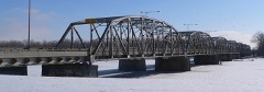
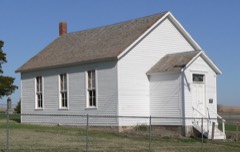
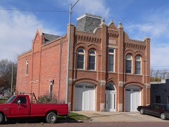
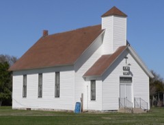
20 National Register listings published here.
Sources: the National Register database, National Park Service
37 topographic sheets cover 17 settlements here, and 20 properties are on the National Register of Historic Places.
20 National Register listings published here.
Sources: the National Register database, National Park Service
Every property in this county listed on the National Register of Historic Places, with the year it was listed and the federal nomination document.
Every wildfire the federal occurrence database records inside this county: 135 of them, burning about 759 acres. 2 started naturally and 3 were recorded as arson. Each settlement page carries the fires within five miles of it.
| Reported cause | Fires |
|---|---|
| Debris and open burning | 56 |
| Missing data/not specified/undetermined | 24 |
| Equipment and vehicle use | 18 |
| Railroad operations and maintenance | 11 |
| Smoking | 7 |
| Power generation/transmission/distribution | 7 |
| Fireworks | 5 |
| Arson/incendiarism | 3 |
| Natural | 2 |
| Misuse of fire by a minor | 1 |
| Recreation and ceremony | 1 |
The five largest, by the area the report gives. One of them was set deliberately.
| Date | Cause | Size | Reported by | Name on the report |
|---|---|---|---|---|
| 21 February 2014 | Equipment and vehicle use | 150 acres | Nebraska Forest Service | not named |
| 23 April 2019 | Debris and open burning | 100 acres | Nebraska Forest Service | not named |
| 13 February 2013 | Equipment and vehicle use | 100 acres | Nebraska Forest Service | not named |
| 28 June 2009 | Arson/incendiarism | 35 acres | Nebraska Forest Service | not named |
| 29 February 2020 | Debris and open burning | 35 acres | Nebraska Forest Service | not named |
| 9 March 2014 | Debris and open burning | 30 acres | Nebraska Forest Service | not named |
| 16 January 2014 | Missing data/not specified/undetermined | 30 acres | Nebraska Forest Service | not named |
| 13 October 2015 | Equipment and vehicle use | 25 acres | Nebraska Forest Service | not named |
Every settlement page carries the fires within five miles of it - see the settlement index below.
The NOAA Storm Events Database holds 526 reports for this county, causing 2 deaths, 19 injuries and about $16,354,730 in recorded property damage. Each settlement page carries the reports that name it.
| Kind of event | Reports |
|---|---|
| Hail | 236 |
| Thunderstorm Wind | 186 |
| Tornado | 36 |
| Flood | 27 |
| Flash Flood | 24 |
| Funnel Cloud | 9 |
| Heavy Rain | 5 |
| Lightning | 3 |
The most serious of them, by death, then injury, then recorded damage. The accounts are quoted exactly as the forecast office filed them.
| When | Event | Place named | Harm | What the report says |
|---|---|---|---|---|
| March 2019 | Flood | Monroe | 1 killed, $440,000 | This is for flooding along the Loup River. The river gage at Columbus, operated by the Nebraska DNR, peaked at 19.39 feet at 5 am on March 15th. Major flood stage is 20 feet. Preliminary this peak is the 2nd highest on record. This flooding caused substantial damage to the area, specifically on the river side of the levee around Columbus. This damage was the result of both ice jam and open water flooding. Several businesses and homes were destroyed and many people needed to be rescued. The water got within 1 to 2 feet of the top of the levee and never got into Columbus. One woman was killed by flood waters in her home. Rescuers could not get to her home due to extreme weather conditions. Property damage amounts represent amounts for the entire county. |
| March 2019 | Flood | Platte Center | 1 killed | This is for flooding along the Shell Creek. The river gage near Columbus, operated by the USGS, peaked at 22.21 feet at 7:30 am on March 14th. Major flood stage is 22 feet. Preliminary data shows that this peak is the 2nd highest on record. US Highway 81 was flooded over from high waters from Shell Creek. Much rural property was inundated by flood waters. A bridges were taken out by flooding. A Columbus man drowned on the 14th while driving his tractor north on, 175th Avenue and over the Shell Creek Bridge. The bridge gave way and the man was swept away by flood waters. Dollar amounts for the county are included in the Loup River flood entry. |
| June 1998 | Tornado (F2) | Columbus | 17 hurt, $4,000,000 | Two farm houses destroyed. Six farm houses severely damaged. One house blown off foundation. Bar destroyed. Center pivots overturned. Severe crop damage. |
| December 2021 | Tornado (EF2) | Columbus | 2 hurt | A narrow, fast-moving, tornado began in the parking lot of a business along Howard Blvd where it tipped over a semi trailer and proceeded to cause roof, siding, fence, and tree damage. Approximately one block later, it caused the worst damage of the entire track where an attached garage and entire roof were removed from a ranch home. Much of the roof was deposited 20 to 100 yards downstream. The tornado proceeded to produce sporadic damage over the next two blocks and then a more consistent damage path for a 6 block period where many homes had minor to moderate roof damage and several trees were snapped or uprooted. There was then another 5 blocks of sporadic minor to moderate tree and roof damage followed by a 2 block stretch of continuous minor to moderate roof and siding damage. The tornado then travelled across open fields until reaching the Indian Hills neighborhood where it snapped two power poles and caused generally minor damage to a fence and shingles, with no further damage downstream. The entire 2.7 mile track occurred in approximately 2 minutes. |
| May 1999 | Hail | Columbus | $7,500,000 | Numerous hailstones 1 1/4 to 1 1/2 inches with some as large as 2 3/4 inches did damage to over 1500 cars as well as to many roofs and gutters. |
| May 1954 | Tornado (F4) | not stated | $2,500,000 | no account filed |
| August 2003 | Thunderstorm Wind | Columbus | $300,000 | A possible thunderstorm microburst hit around a 1 mile area northwest of Columbus. The winds, estimated at over 70 mph, took a tin roof off of local power company cement block building. Four garage doors on that building were also destroyed or heavily damaged. Another nearby business sustained serious damage and a farmstead, also close by, had several large trees toppled by the winds one of which damaged a grain bin. |
| May 2008 | Flash Flood | Lindsay | $250,000 | Rainfall of 2 to 4 inches, with some unofficial reports of 8 inches, caused flash flooding from around Lindsay through the Platte Center area along Shell and Elm Creeks. The flooding was most pronounced along Elm Creek in Platte Center where 50 to 70 homes and 10 businesses sustained flood damage. The flood waters also caused propane tanks to float down streets in town and forced most people to evacuate. Two city parks were also flooded Portions of the town remained flooded well through the 30th. |
| June 1990 | Tornado (F0) | not stated | $250,000 | no account filed |
| July 1986 | Tornado (F1) | not stated | $250,000 | no account filed |
| June 2010 | Flood | Lindsay | $200,000 | Heavy rain from roughly June 7th into the 14th produced prolonged flooding along Shell Creek and its tributaries from near Lindsay in Platte county downstream to near Platte Center then to around Schuyler in Colfax county. The high water flooded many county roads and forced the closure of Highway 81 northwest of Columbus and also Highway 91 between Humphrey and Lindsay. A motorist had to be rescued by area residents late on the 10th when his vehicle became flooded while attempting to drive through flood waters west of Platte Center, the motorist was uninjured. Cropland was also damaged because of the high water. Shell Creek near Columbus crested around 21.6 feet for a prolonged period from late morning on June 12th until early morning on the 13th. Flood stage is 20 feet. The creek near Columbus was above flood stage from the evening of June 11th until the late afternoon hours of June 14th, although flooding occurred earlier than the 11th upstream of the gauge and probably lasted longer than the 14th downstream. |
| May 2012 | Tornado (EF2) | St Bernard | $100,000 | A brief tornado from a low-topped mini-supercell destroyed a farm house a few miles west northwest of Cornlea. The house had it's roof lifted off which caused several walls to collapse. The family in the house had seen the tornado approach and had taken cover in the basement and were uninjured. |
| May 2000 | Thunderstorm Wind | Lindsay | $100,000 | An intense bow echo line of thunderstorms caused a swath of damage 3 miles wide and 10 miles long centered near and just north of Lindsay. Wind gusts were measured at 109 mph by a wind recording instrument at the Lindsay Manufactoring Co., causing around 40 thousand dollars worth of damage at the plant itself. The winds overturned at least 10 center pivot irrigation units in this area, toppled a metal silo 1.5 miles northeast of Lindsay and destroyed the top of a cement silo 1 mile west of Lindsay. |
| May 2024 | Flash Flood | Creston | $50,000 | The office received a public report of water and debris flowing over Monastery Road in northeast Platte County. About an hour after this report, the office received another public report that a bridge near Monroe was closed due to water flowing over the top of it and over the hood of a full-sized pickup truck. |
| August 2017 | Flash Flood | Monroe | $50,000 | A county road was closed near Monroe due to flash flooding. |
| June 2014 | Flash Flood | Columbus | $50,000 | Heavy rainfall led to significant street flooding in the city Columbus, especially on the south side of town. The flooding was deep enough in places that water overflowed into the yards of homes. |
| October 2001 | Thunderstorm Wind | Humphrey | $40,000 | This storm produced thunderstorm wind gusts estimated at around 80 mph downing numerous trees and large tree limbs in the Humphrey area. Also a city maintenance building roof was blown off. Although funnel clouds were reported with the storm, no tornadoes touched down in the Humphrey area according to the Platte county Emergency Manager. |
| June 1990 | Tornado (F0) | not stated | $25,000 | no account filed |
| June 1990 | Tornado (F0) | not stated | $25,000 | no account filed |
| October 1974 | Tornado (F0) | not stated | $25,000 | no account filed |
| June 2010 | Flash Flood | Lindsay | $20,000 | Rainfall of around 3 inches in an hour or so brought flash flooding along Shell Creek and tributaries near and south of Lindsay. The flooding closed Lindsay Highway that runs south from town to Highway 22 and flooded the Lindsay Manufacturing parking lot and pedestrian bridge. The rain fell on saturated soils due to rains that fell earlier in the week and most of the damage from this flood was confined to gravel washed off of county roads and some crop damage. |
| May 2000 | Thunderstorm Wind | Humphrey | $20,000 | Besides possibly producing the spin up tornado in Humphrey, the strong winds associated with the thunderstorm that caused extensive damage in the Lindsay area, also caused damage in Humphrey. Besides tree damage, a newly erected grain bin was partially destroyed. An insurance agency in Humphrey reported at least 17 center pivots in the area were overturned, although this number may include some of those reported in the Lindsay area. |
| June 2000 | Thunderstorm Wind | Lindsay | $20,000 | Thunderstorm winds estimated around 70 mph broke power poles and overturned center pivots near Lindsay. |
| July 1998 | Lightning | Columbus | $20,000 | Lightning struck a home causing a fire. |
| May 2007 | Thunderstorm Wind | Columbus | $15,000 | Thunderstorm wind gusts estimated at close to 60 mph caused significant damage to an abandoned trailer and did some tree and sign damage for about 1 mile long and 1 block wide on the northeast side of town. |
| June 2024 | Flash Flood | Creston | $10,000 | A trained spotter reported flood waters over county roads from overnight thunderstorms. |
| March 2010 | Flood | Sheldonville | $10,000 | Snow melt and rain caused the Loup River to rise which then caused several ice jams from around Genoa downstream to the Lake Oconee area southwest of Columbus. This caused lowland flooding in Platte county from near Monroe to a little southeast of Lake Oconee. Several county roads in the region were flooded as were agricultural lowlands. Any damage was mainly confined to washing gravel off of the roads. |
| June 1999 | Flash Flood | Humphrey | $10,000 | Three to 5 inches of rain in northern Platte county caused extensive flash flooding which closed highway 91 just west of its junction with highway 81. A pickup with 2 people in it was washed off of highway 91 near Humphrey and swept 1/2 mile downstream totally destroying the truck. The occupants were not hurt. |
| June 1998 | Lightning | Columbus | $10,000 | Lightning struck an apartment building and started a fire. |
| July 1996 | Thunderstorm Wind | Columbus | $10,000 | no account filed |
| August 1996 | Thunderstorm Wind | Columbus | $10,000 | no account filed |
| June 2024 | Flood | Creston | $5,000 | The office received a public report of water still over the southbound lane of Highway 81 in northeastern Platte County. This is a continuation of flash flooding that occurred from overnight thunderstorms the night prior. |
| May 2000 | Thunderstorm Wind | Columbus | $5,000 | Thunderstorm winds toppled signs and a few trees in Columbus. |
| June 1999 | Thunderstorm Wind | Humphrey | $5,000 | Winds over 60 mph blew down signs along highway 81 in northern Platte County. |
| July 1996 | Thunderstorm Wind | Creston | $5,000 | no account filed |
| July 1996 | Tornado (F0) | Monroe | $4,000 | no account filed |
| June 1997 | Lightning | Columbus | $3,000 | Lightning struck a home. |
| May 1973 | Tornado (F0) | not stated | $2,500 | no account filed |
| June 1971 | Tornado (F0) | not stated | $2,500 | no account filed |
| June 1957 | Tornado (F1) | not stated | $2,500 | no account filed |
| June 2010 | Flood | Platte Center | $2,000 | Rainfall of another 1 to 2 inches June 22 fell across parts of the Shell Creek basin near and north of Columbus. The rains fell on saturated soils due to the over 5 to 8 inches of rain that fell earlier in the month. This produced some lowland flooding along Shell Creek from near Platte Center to east of Highway 81. The high water closed county roads and Highway 81 for a while on the 23rd and 24th in addition to flooding farmland along the creek. |
| June 2010 | Flood | Monroe | $2,000 | Rainfall of at least 3 to 5 inches fell over much of the Loup River basin in the week ending 7am 6/12. This caused minor lowland flooding along the Loup River from near Monroe downstream toward Columbus, although a dike along the north bank of the river protected much of the Columbus area. The flooding mainly affected agricultural lowlands near the river and also a few county roads in southwest Platte county near Monroe. |
| May 2008 | Flash Flood | Humphrey | $2,000 | Heavy rain produced flash flooding along Tracy Creek near Humphrey which flooded across Highway 91. |
| October 2007 | Flood | Humphrey | $2,000 | no account filed |
| June 2025 | Flash Flood | Monroe | $1,000 | During the afternoon of June 25th into the morning of June 26th, several rounds of moderate to heavy rain moved through Platte County with rainfall rates of at least 1 inch per hour at times. This led to flooding in southwestern portions of the county, with emergency management reporting road closures lasting into the afternoon of the 26th. |
| June 2025 | Flood | Monroe | $1,000 | During the afternoon of June 25th into the morning of June 26th, several rounds of moderate to heavy rain moved through Platte County with rainfall rates of at least 1 inch per hour at times. This led to flooding in southwestern portions of the county, with emergency management reporting road closures lasting into the afternoon of the 26th. |
| May 2008 | Flash Flood | Platte Center | $200 | Heavy rain caused water to flow over a few roads in the Platte Center area with mud and other debris on the road. The flooding was along Shell Creek tributaries and subsided after a short time. |
| May 1987 | Tornado (F0) | not stated | $30 | no account filed |
| March 2025 | Thunderstorm Wind | Creston | - | Personal weather station measured 59 mph wind gust. |
| March 2025 | Hail | Humphrey | - | Public of dime to quarter size hail falling for 5 minutes with 40 to 50 mph wind gusts. |
| June 2025 | Hail | Rosenburg | - | Trained spotter report of hail measured up to 1.75 inches in diameter. |
| May 2025 | Thunderstorm Wind | Tarnov | - | Emergency management report of a semi truck blow over east of Tarnov. |
| May 2025 | Hail | Columbus | - | Public report of hail estimated up to 1 in diameter. |
| May 2025 | Hail | Columbus | - | Public report of hail measured up to 1.25 in diameter. |
| May 2025 | Hail | (Olu)Columbus Arpt | - | Public report of hail measured up to 3 in diameter. |
| May 2025 | Hail | Brandts Arpt | - | Public report of hail estimated up to 1.75 in diameter. |
| May 2025 | Hail | Brandts Arpt | - | Public report of hail measured up to 1 in diameter. |
| May 2025 | Thunderstorm Wind | (Olu)Columbus Arpt | - | Personal weather station wind gust measured at 58 mph. |
| July 2025 | Flash Flood | Newman Grove | - | During the evening of July 7th, heavy rainfall moved through northwest Platte county with rainfall rates of 1.5-3 inches per hour at times with an estimated 3-4 inches of total rainfall. This led to flash flooding with emergency management reporting water over the roadway 1.5 miles east of Highway 91 and 45. This flash flood also continued into Boone and Madison counties. |
| July 2025 | Thunderstorm Wind | Columbus | - | Public report received via social media of wind gusts estimated at 60 mph on the northwest side of Columbus, NE. |
The Survey's mineral resources record lists 3 workings inside this county. All of them still produce. Each settlement page carries the workings within five miles of it.
| Commodity | Workings |
|---|---|
| Sand and Gravel, Construction | 3 |
The least common of them first, because a county's hundredth gravel pit says nothing its first ten did not.
| Where | Site | Commodity | Status | Recorded |
|---|---|---|---|---|
| Columbus Pit & Plant | Sand and Gravel, Construction | Producer | ||
| Pg-S Sand & Gravel Pit & Plant | Sand and Gravel, Construction | Producer | ||
| Po-2 Oconee Pit and Plant | Sand and Gravel, Construction | Producer |
Named settlements recorded in the Geographic Names Information System, each with the topographic sheets covering it. Villages, hamlets and abandoned places alike. Each is shown with the nearest named watercourse or landform and the survey quadrangle it falls on.
Butler township · 68601 · On Prairie Creek · Silver Creek SE quadrangle
13 sheets, 1896 to 1985
Lost Creek township · 68653 · On Elm Creek · Platte Center quadrangle
8 sheets, 1955 to 1985