 Block
Adams, Nebraska
11 topographic sheets cover this place, the earliest surveyed in 1955 and the latest in 1986. It stands in Adams Township. It lies in ZIP code area 68301. It stands on Jakes Creek. The Survey maps it on the Adams quadrangle. 604 people lived here at the 2020 count. It stands 1,253 feet above sea level.
On record in Adams
Buildings and businesses the archive holds for this place. Each opens its own page, with the source record it came from.
On the National Register 1 record
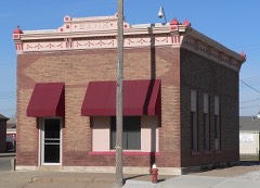 Farmers State Banklisted 1992
Population over time
2 figuresAdams grew from 573 to 604 between 2010 and 2020. These are the recorded population figures Wikidata holds for this place, reached through the Geographic Names Information System number this page is keyed on rather than by name, so they belong to this place and not to another of the same name. Most are census counts, but not all are: an early figure may be a founding or settlement estimate, and an estimate published within five years of a census is left out. The change column is computed, and is left blank where more than 20 years separate a figure from the one before it, because a gap that long is not a change between two counts.
| Year | People | Change |
|---|---|---|
| 2010 | 573 | |
| 2020 | 604 | +31 (+5%) |
Topographic sheets covering this place
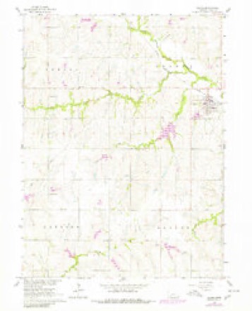
5 surveys from 11 printed sheetsMatched by testing this settlement's coordinate against the published boundary of every sheet in the United States Geological Survey's historical collection. Each opens the scanned sheet at the Survey.
- 1955 USGS Lincoln quadrangle1:250000, 5 printings
- 1957 USGS Lincoln quadrangle1:250000
- 1958 USGS Lincoln quadrangle1:250000
- 1965 USGS Adams quadrangle1:24000, 2 printings
- 1986 USGS Beatrice quadrangle1:100000, 2 printings
In the county-history sources
9,774 words on this townshipHistory of Gage County, Nebraska; a Narrative of the Past, with Special Emphasis Upon the Pioneer Period of the County's History, Its Social, Commercial, Educational, Religious, and Civic Development from the Early Days to the Present Time, published 1918 names this settlement in its chapter on Adams Township. These are the passages that mention it, exactly as the scans read.
Isma. p. and Elizabeth Mumford were amongst the first pioneers in Gage county. Isma P. Mumford was born in the state of Maryland, while Elizabeth Mallock, was born in Adams county, Ohio, in 1830. She was the granddaughter of a Revolutionary soldier and the daughter of a man who bore arms for his country in the war of 1812. When twenty-one years of age she became the wife of Isma P. Mumford. Shortly after their marriage, in 1853, they migrated from Ohio to the new state of Wisconsin, and in 1857 they came seeking a home in the new territory of Nebraska. On the way out they were joined at Plattsmouth by William and Nathan Blakely, and together these heroic pioneers of Gage county made their slow way across the unmarked, trackless prairies of southeastern Nebraska. Hearing that the Big Blue river valley olifered great advantages to settlers, on account of the abundant limber and rich bottom land which Hned its course, they traveled thither, and on the 17th day of July, almost by accident, stumbled upon the members of the Beatrice Townsite Company, who were' engaged in erecting a company house on their townsite, which building later became the property of Albert Towle and widely famous as "Pap's Cabin." They also found a cluster of covered wagons and tents, in the neighborhood of the Kees Manufacturing plant, a little above the junction of Indian creek and the Big Blue river. Learning that the representatives of the townsite company had founded a town and purposed to remain arid carry their enterprise to fulfillment, and pleased both with the prospect and company, the little party resolved to cast in its fortunes with that old guard which then and for many succeeding years held this remote outpost of civilization against all hardships, privations and discouragements.
Passage source: History of Gage County, Nebraska; a Narrative of the Past, with Special Emphasis Upon the Pioneer Period of the County's History, Its Social, Commercial, Educational, Religious, and Civic Development from the Early Days to the Present Time, published 1918.
As early as 1867 a postoffice was established in Adams township, called Laona. John Lyons was the first postmaster, the postoffice being at his home, a mile and one-half west of the present town of Adams. In 1873 the Atchison & Nebraska Railroad Company built its line of railway through Adams township from Atchison to Lincoln, and in May of that year John O. Adams, in conjunction with the railroad company, laid off the south half of the northeast quarter of section 27, into a townsite and it was named Adams. Village organization was deferred until March 10, 1892. The first board of village trustees comprised the following well known residents of that place, namely: Frank E. Whyman, Henry H. Norcross, W. C. Garrison, Nathaniel C. Shaw, and William C. Gray. They were duly qualified for office by James B. Shaw, justice of the peace. F. E. Whyman was elected first chairman of the village board, W. C. Gray the first secretary, and H. L. Watson was appointed the first marshal of Adams. One of the first ordinances passed prohibited "the sale, giving away, delivering or furnishing in any manner any spirituous, malt, vinous or intoxicating liquors within the village," an ordinance which has stood intact from the beginning. The open saloon never found a place to conduct business in Adams.
Passage source: History of Gage County, Nebraska; a Narrative of the Past, with Special Emphasis Upon the Pioneer Period of the County's History, Its Social, Commercial, Educational, Religious, and Civic Development from the Early Days to the Present Time, published 1918.
The town of Adams has flourished from the beginning. It was supported by an unusually intelligent, progressive and loyal class of citizens. Amongst them the Whyman family, who came overland from western Pennsylvania, consisting of the parents and twelve children; the Adams family and the Shaw family, of whom mention has already been made in this work in the chapter on the early settlers in this county; the Silas Bryson family, who came from Ohio by boat down the Ohio river and up the Mississippi and Missouri, consisting of the parents and fourteen robust sons and daughters, who have contributed ably to the making of the state of Nebraska; William Curtis, who was the fourteenth man to make homestead entry at the Brownville land office, and his family; H. J. Merrick, who is a veteran of the Civil war and who has proved a force in the upbuilding of the village ; Byron P. Zuver, Stephen Disher, John Lyons, George and Alfred Gage, L. R. Horrum and his son, Dr. J. W. McKibbin, and many other residents of the town of Adams and vicinity.
Passage source: History of Gage County, Nebraska; a Narrative of the Past, with Special Emphasis Upon the Pioneer Period of the County's History, Its Social, Commercial, Educational, Religious, and Civic Development from the Early Days to the Present Time, published 1918.
Machine-read from a century-old scan, so expect the errors a machine makes: misspelled names, dropped words, stray characters.
Read the whole chapter on Adams Township - it names this place 10 more 10 times.
Fires near this place
14 since 2003Regional context, not property-specific evidence. The federal wildfire occurrence database lists 14 fires within 5 miles of Adams between 2003 and 2013, burning about 43 acres in total. None started naturally. None was recorded as arson. Distance is straight-line from the map coordinates, so a fire counted here may appear on a neighbouring settlement's page as well.
| Reported cause | Fires |
|---|---|
| Debris and open burning | 12 |
| Missing data/not specified/undetermined | 1 |
| Recreation and ceremony | 1 |
The most recent of them, most recent first, with the day each was reported and the service that recorded it.
| Date | Cause | Size | Reported by | Name on the report |
|---|---|---|---|---|
| 20 August 2008 | Debris and open burning | under an acre | Nebraska Forest Service | not named |
| 9 April 2009 | Debris and open burning | under an acre | Nebraska Forest Service | not named |
| 2 April 2009 | Debris and open burning | 1.0 acres | Nebraska Forest Service | not named |
| 1 April 2009 | Debris and open burning | 10 acres | Nebraska Forest Service | not named |
| 24 March 2011 | Debris and open burning | 10 acres | Nebraska Forest Service | not named |
| 23 March 2009 | Recreation and ceremony | 1.0 acres | Nebraska Forest Service | not named |
| 22 March 2008 | Debris and open burning | under an acre | Nebraska Forest Service | not named |
| 21 March 2009 | Debris and open burning | 12 acres | Nebraska Forest Service | not named |
Settlements close enough to share some of these fires:
Storms near this place
35 since 1998Regional context, not property-specific evidence. The National Weather Service names Adams in 35 storm reports between 1998 and 2023: 22 hail, 11 thunderstorm wind, 1 lightning, 1 tornado. No death or injury is recorded in these reports. Each account below is quoted exactly as the forecast office filed it, from the NOAA Storm Events Database, and each date opens the federal record of that event.
| When | Event | Place named | Harm | What the report says |
|---|---|---|---|---|
| April 2006 | Tornado (F0) | Adams | $55,000 | A tornado, estimated at fo strength, touched down about 5 to 6 miles south of Adams. The tornado tore roofs off three hog barns, a chicken shed and blew out windows to several houses. One farmstead reported around $55,000 in damage. The tornado also caused tree damage along its 5 to 6 mile path, lifting about 1/2 mile southwest of Adams. The average damage path width was around 200 yards. |
| May 2023 | Hail | Adams | - | Public reported 1-inch hail. |
| June 2023 | Thunderstorm Wind | Adams | - | A wind gust peeled off the roof of a chicken outbuilding. |
| June 2020 | Thunderstorm Wind | Adams | - | Public reported a large tree limb snapped off. |
| June 2020 | Thunderstorm Wind | Adams | - | Emergency manager reported a measured wind of 76 mph. |
| June 2013 | Thunderstorm Wind | Adams | - | Several large trees were uprooted and other tree and house damage was noted in the Adams area by thunderstorm wind gusts estimated at around 70 mph. |
| May 2013 | Thunderstorm Wind | Adams | - | The estimated gust tore shingles off homes in the city of Adams. |
| May 2011 | Hail | Adams | - | A spotter reported pea to quarter-size hail in the Adams area. |
| May 2011 | Thunderstorm Wind | Adams | - | Thunderstorm wind gusts estimated at 60 mph downed a few 2 to 3 inch in diameter tree limbs in the area. The winds were accompanied by hail up to quarter-size. |
| May 2011 | Hail | Adams | - | A second area of severe thunderstorms produced pea to quarter-size hail in the Adams area within an hour. |
| June 2011 | Thunderstorm Wind | Adams | - | Thunderstorm wind gusts estimated at over 60 mph downed several trees and power lines near Adams. |
| June 2009 | Thunderstorm Wind | Adams | - | Thunderstorm wind gusts estimated at over 60 mph downed a few trees in the area. The winds were accompanied by half dollar-size hail. |
| June 2009 | Hail | Adams | - | Hail up to half dollar-size was accompanied by thunderstorm winds that also downed a few trees. The wind driven hail damaged numerous homes and cars in and around Adams and also caused crop damage in the area. One local insurance agent had already received 50 agriculture/crop claims and 150 house and auto claims by Monday morning June 8th, with many, many, many claims against roof, siding and paint damage to come he stated. |
| July 2008 | Thunderstorm Wind | Adams | - | A spotter estimated thunderstorm wind gusts as high as around 60 mph in the Adams area. |
| May 2006 | Thunderstorm Wind | Adams | - | Thunderstorm winds estimated at 70 mph downed large tree limbs. |
| May 2002 | Lightning | Adams | - | A lightning bolt hit a 75 year-old oak tree in Adams. The tree was toppled, blocking a street and shattering the tree. The fallen tree damaged a house and 2 cars. One limb of the tree lodged itself into a garage door and several large oak splinters imbedded themselves in the house. |
| July 2000 | Hail | Adams | - | See narrative above. |
| May 1998 | Thunderstorm Wind | Adams | - | Garage destroyed. Machine shed destroyed. |
| May 2015 | Hail | Adams | - | no account filed |
| May 2015 | Hail | Adams | - | no account filed |
| August 2011 | Hail | Adams | - | no account filed |
| June 2011 | Hail | Adams | - | no account filed |
| April 2010 | Hail | Adams | - | no account filed |
| August 2007 | Hail | Adams | - | no account filed |
| June 2006 | Hail | Adams | - | no account filed |
| May 2006 | Hail | Adams | - | no account filed |
| July 2006 | Hail | Adams | - | no account filed |
| March 2005 | Hail | Adams | - | no account filed |
| April 2005 | Hail | Adams | - | no account filed |
| April 2005 | Hail | Adams | - | no account filed |
| April 2005 | Hail | Adams | - | no account filed |
| August 2004 | Hail | Adams | - | no account filed |
| May 2003 | Hail | Adams | - | no account filed |
| August 2001 | Hail | Adams | - | no account filed |
| August 2001 | Hail | Adams | - | no account filed |
Nearest settlements
The eight closest, with where each one stands in the county. Distances are straight-line, computed from the Geographic Names Information System coordinates.
Elsewhere
Matched on this settlement's Geographic Names Information System number rather than its name, so it cannot be a different place of the same name in another state.
| Wikipedia article on Adams | An encyclopaedic summary. Its text is share-alike, so it is linked here rather than copied. |
| Wikidata item Q3462135 | The structured record the population and elevation above come from. Public domain (CC0). |
Provenance
This settlement is recorded in the Geographic Names Information System as feature 826897. The sheet list is computed by point-in-boundary test against the United States Geological Survey's historical topographic inventory. Both are works of the United States government and carry no copyright under 17 U.S.C. 105.
Wildfire. Short, Karen C. 2022. Spatial wildfire occurrence data for the United States, 1992-2020 [FPA_FOD_20221014]. 6th Edition. Fort Collins, CO: Forest Service Research Data Archive. https://doi.org/10.2737/RDS-2013-0009.6 Collected with United States Government funding and usable without additional permissions or fees.
Storms. NOAA National Centers for Environmental Information, Storm Events Database https://www.ncei.noaa.gov/stormevents/ A work of the United States government, no copyright under 17 U.S.C. 105. Narratives are quoted verbatim from the National Weather Service report and are not edited or summarised.