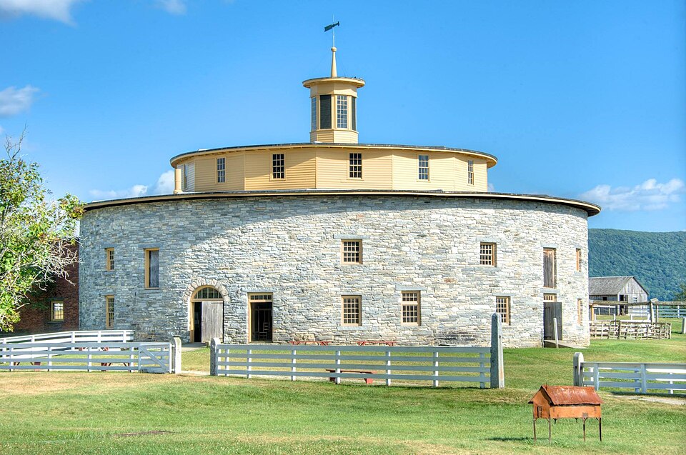
A National Historic Landmark. Listed on the National Register of Historic Places in
1968. A historic map-sheet match is not published yet. The record needs a coordinate-quality review before it can be joined to a sheet boundary.
From the record
“Hancock Shaker Village is a former Shaker commune in Hancock and Pittsfield, Massachusetts. It emerged in the towns of Hancock, Pittsfield, and Richmond in the 1780s, organized in 1790, and was active until 1960.”
Wikipedia article Hancock Shaker Village, CC BY-SA 4.0.
one of 94 National Register listings in Berkshire County · listed in 1968 · category: Building · one of 1 National Historic Landmarks in Berkshire County.
National Register reference number.68000037- the number the National Park Service assigned this property when it was listed, and the key its nomination file is catalogued under at the National Archives.
In examining the map, it will be noticed that dwellings are much more thickly scattered along the streets running east and west than upon those intersecting them at right angles ; and the same difference would be observed if it had been extended to embrace the whole of the original settling-lots. There were two causes for this. . First, the great highway between Boston and Albany ran through East and "West streets. But secondly, and chiefly, it arose from the mode in which the lots were originally laid out. There were, it will be recollected, three tiers of hundredacre farms, lying side by side and extending from the east to the through the center of the township. One of these tiers reached the whole length of the town, while that north of it fell a mile and a half short of the Dalton border, and that upon the south something more than two miles short of the Hancock line; the three ranges being separated from each other by roads seven rods wide. They were also intersected by a road,seven rods wide, running nearly through the center of the township from north to south, and now known as North and South streets, and in the east and west parts by other roads. The extreme width of these joint proprietor with Colonel Wendell, and Edward Livingstone, of Pooutoosuc, died in 3872, of consumption, aged forty-one. He lies buried with his widow and several of his children on the eastern slope of Pontoosuc Hill in the Pitts - field cemetery; where his grave is marked by a large old-fashioned tombstone, bearing this exceedingly-apposite epitaph :
But to return to the system of roads, in Pittsfield, which was distinguished for its regularity. The road from Lenox to Lanesboro, of which North and South streets were a part, extended through Pittsfield nearly in a straight line, passing through the present site of the high-school house, and over the hill north of Maplewood Institute, and that west of Pontoosuc Lake. East and West streets, as now, extended from a point half a mile east of the park, in a straight line to the Hancock borders. Owing to the swamp east of that point, the highway diverged thence south-east, through Water and Elm streets. These intersecting roads, practically only two, may be considered the trunk, or base, of the whole system. From North street, about half a mile north of Maplewood, a street turned a little to the north-west and passing near the present entrance of the cemetery, joined and continued through Otaneaque street; forming the avenue by which the people of the North woods, and several of the forge neighborhoods, reached the central village. Wahconah street was not yet opened. Farther north a road, crossing the outlet of Pontoosuc lake, wound along its west side. From South street, Honasada street - one of the originally-reserved roads - was actually opened eastward to the Dal ton line. Westward, there continued to be an unmade portion until the line reached a point near Oceola village, whence it was completed to the foot of the mountain. Beyond the river. South Mountain street wound along the base of the hill from which it takes its name. From Otaneaque street, to the western extension of Honasada street, three roads ran north and south crossing. West street. From West street, also ran Onota street, north to Seymour's iron forge. On West street again, east of the river, Mill street led south to Luce's mill. From Honasada street. Shearer's lane ran south along the east side of the farm which had heen owned by Colonel Williams ; and from the same street a road ran south and south-west, to " Eock mountain ;" now known as the Sikes district, famous for its very hard and peculiarly-stratified granular quartz.
Regional context, not property-specific
evidence. The
federal wildfire occurrence database
lists 123 fires within 5 miles of Hancock Shaker Village Trustees House between
2002 and 2020, burning about 106 acres in total. 3 started naturally. 1 was recorded as arson.
Distance is straight-line from the map coordinates, so a fire counted
here may appear on a neighbouring settlement's page as well.
Reported cause
Fires
Debris and open burning
46
Missing data/not specified/undetermined
43
Recreation and ceremony
11
Railroad operations and maintenance
6
Smoking
5
Equipment and vehicle use
4
Natural
3
Misuse of fire by a minor
2
Power generation/transmission/distribution
1
Other causes
1
Arson/incendiarism
1
The most recent of
them, most recent first, with the day each was reported and the service
that recorded it.
Regional context, not property-specific
evidence. Museums hold 1,234 specimens
collected within 10 miles of Hancock Shaker Village Trustees House between 1833 and
1975: 569 Plantae, 362 Animalia, 295 Fungi, 4 Unrecorded, 2 Chromista, 2 Protozoa. 12 distinct Species records are shown.
Collected by A W Evans, A. Brown, A. H. Mead and others. Each is a
physical object with a catalogue
number, and each entry opens the museum's record. This is what was
collected and kept, not a survey of what lives here - nothing can be
concluded from a species being absent.
Regional context, not property-specific
evidence. The federal mineral resources record lists
22 workings within 5 miles of Hancock Shaker Village Trustees House: 13 past producers, 5 producers, 4 occurrences.
5 still produce. What was taken out: Iron, Iron, Manganese, Manganese, Limestone, General. Distance is straight-line from the
map coordinates, so a quarry counted here may appear on a neighbouring
settlement's page as well.
Regional context, not property-specific
evidence. The National Weather Service names
Hancock, the town this property stands in, in 9 storm reports between 2000 and 2022: 5 thunderstorm wind, 2 hail, 1 lightning, 1 flash flood.
No death or injury is recorded in these reports. Each account below is quoted exactly as the forecast office
filed it, from the NOAA Storm Events Database, and each date
opens the federal record of that event.
Heavy rainfall from thunderstorms heavily damaged a 1.5 mile stretch of the Berry Pond Circuit Road in the Pittsfield State Forest in Pittsfield. As a result of the flash flooding, 13 popular campsites at Berry Pond had to be closed for the remainder of the summer season due to the damaged access road. A local newspaper reported that when the flash flooding occurred, campers had to be evacuated before water cascading down the mountain gouged out the paved road. The damage to the road and eleven stone culverts was estimated to be significant and will cost between $173,000 and $277,000 to repair.
A tree, along with wires were reported down on Route 43 in Hancock due to strong thunderstorm winds. An estimated wind gust of 60 miles per hour was also reported.
Thunderstorms developed along a frontal boundary, then moved into Berkshire county very late on August 9. Dime to nickel size hail was reported by a spotter in Hancock.
No historic map-sheet match is published
for this property yet. That does not mean no map exists. This record needs
a coordinate-quality review before it can be joined to a sheet boundary.
Browse the county's mapped places while that work is
pending.
Listed places nearby
6 within 8 miles
Other National Register properties close
enough to walk or drive between, ordered by distance from this one. Both
positions come from the same geocoding pass that matched these properties
to their map sheets.
Listing record. National Park Service National Register of Historic Places, listed-properties dataset, current to 2026-05-22.
Map join. Address geocoded through the United States Census geocoder, then tested against the published boundary of every sheet in the USGS Historical Topographic Map Collection.
How this page is made. Listing fields come from federal records; map-sheet coverage is a labelled coordinate-to-boundary calculation, not a source-field claim.
Wildfire. Short, Karen C. 2022. Spatial wildfire occurrence data for the United States, 1992-2020 [FPA_FOD_20221014]. 6th Edition. Fort Collins, CO: Forest Service Research Data Archive. https://doi.org/10.2737/RDS-2013-0009.6 Collected with United States Government funding and usable without additional permissions or fees.
Specimens. Global Biodiversity Information Facility (GBIF), https://www.gbif.org/. Only records licensed CC0 or CC BY are used. Records licensed CC BY-NC are excluded because this site carries advertising. Images are checked individually and any whose licence is non-commercial, no-derivatives or unreadable is refused.
Mines and quarries. USGS Mineral Resources Data System (MRDS) https://mrdata.usgs.gov/mrds/ A work of the United States government, no copyright under 17 U.S.C. 105.
Storms. NOAA National Centers for Environmental Information, Storm Events Database https://www.ncei.noaa.gov/stormevents/ A work of the United States government, no copyright under 17 U.S.C. 105. Narratives are quoted verbatim from the National Weather Service report and are not edited or summarised.
 Block
Block