Photographs from the nomination case file, National Park Service records.
Old Chelmsford Garrison House Complex
Listed on the National Register of Historic Places in
1973. A historic map-sheet match is not published yet. The record needs a coordinate-quality review before it can be joined to a sheet boundary.
From the record
“Although the English regarded the Indians as heathen, whose inheritance God would give to His people, yet the Rev. John Eliot and others knew that they had souls, and so were to be brought to a knowledge of the truth.”
History of Chelmsford, Massachusetts (1917). Machine-read text.
one of 1100 National Register listings in Middlesex County · listed in 1973 · category: Building · one of 3 National Historic Landmarks in Middlesex County.
National Register reference number.73000289- the number the National Park Service assigned this property when it was listed, and the key its nomination file is catalogued under at the National Archives.
The Parkers were from Woburn. There were five brothers. Of the four whose names were among the petitioners, none of them long remained in Chelmsford. James went, about 1660, to Groton, where he became the leading man of the town. Joseph also went to Groton and after to Dunstable. Jacob was the first town clerk of Chelmsford, but soon removed to Maiden, and John went to Billerica. The Chamberlins were also from Woburn. Thomas and Edmund settled in Chelmsford and William in Billerica. John Baldwin and George Farley, also from Woburn, settled in Billerica. The first birth in that town was Samuel, the son of George Farley. James Blood and John Nutting took up land here, but both soon went
The plan of the town as laid out by the committee, as here shown, was engraved from a tracing from the original in the Massachusetts Archives, Ancient Plans, vol. 112, p. 81. The space marked " India Land" was the tract reserved for the Indians. Joe ces of the apostle, Eliot, about the time of the grant to the Pawtuckets. At the time of King Philip's War the Indians mostly abandoned their reservation, and it was encroached upon by people from adjoining towns, mostly from Groton. Boundary controversies grew out of this. The Chelmsford line bordered upon this tract for a considerable distance.
Regional context, not property-specific
evidence. The
federal wildfire occurrence database
lists 43 fires within 5 miles of Old Chelmsford Garrison House Complex between
2015 and 2020, burning about 19 acres in total. 1 started naturally. 1 was recorded as arson.
Distance is straight-line from the map coordinates, so a fire counted
here may appear on a neighbouring settlement's page as well.
Reported cause
Fires
Debris and open burning
19
Missing data/not specified/undetermined
17
Recreation and ceremony
3
Natural
1
Smoking
1
Other causes
1
Arson/incendiarism
1
The most recent of
them, most recent first, with the day each was reported and the service
that recorded it.
Regional context, not property-specific
evidence. Museums hold 445 specimens
collected within 10 miles of Old Chelmsford Garrison House Complex between 1898 and
1975: 180 Animalia, 155 Plantae, 78 Fungi, 29 Protozoa, 3 Chromista. 12 distinct Species records are shown.
Collected by A. B. Seymour, A. F. Newton, A. F. Newton, M. K. Thayer and others. Each is a
physical object with a catalogue
number, and each entry opens the museum's record. This is what was
collected and kept, not a survey of what lives here - nothing can be
concluded from a species being absent.
Regional context, not property-specific
evidence. The federal mineral resources record lists
33 workings within 5 miles of Old Chelmsford Garrison House Complex: 20 past producers, 9 producers, 3 plants, 1 occurrence.
12 still produce. What was taken out: Sand and Gravel, Construction, Granite, Copper, Stone, Crushed/Broken. Distance is straight-line from the
map coordinates, so a quarry counted here may appear on a neighbouring
settlement's page as well.
Regional context, not property-specific
evidence. The National Weather Service names
Chelmsford, the town this property stands in, in 25 storm reports between 2003 and 2024: 16 thunderstorm wind, 4 flood, 3 hail, 2 flash flood.
No death or injury is recorded in these reports. Each account below is quoted exactly as the forecast office
filed it, from the NOAA Storm Events Database, and each date
opens the federal record of that event.
Trees and power lines on Jonathan Lane, Warren Avenue and Spaulding Road were downed by thunderstorm winds. A tree in Chelmsford center and another on Boston Road were downed onto cars.
Trees were downed onto Chelmsford Street. Large limbs were downed throughout town. An air conditioning unit was blown off its support on an office roof, but remained on the roof. Trees were downed on Route 110 near Interstate 495.
Trees and power lines on Pine Hill Road were downed by thunderstorm winds. A large maple tree on Meehan Drive was downed onto a roof, destroying a portion of the chimney.
In Chelmsford, a large tree and wires were down on Hunt Road at Alcorn Road; a tree fell onto a house on Riverneck Road; a tree was down on Old Westford Road; and a tree was down on Westford Street.
In North Chelmsford at 445 PM EDT (345 PM EST), Middlesex Street at Cedar Street was closed due to flooding. At 446 PM EDT, significant street flooding was reported on Old Westford Road behind the police station, per police department...relayed by amateur radio.
At 1210 AM EST, street flooding was reported at the junction of Gorham and Moore Streets in Lowell. The Speen Street on-ramp to State Route 9 in Natick was flooded and impassable; Route 9 eastbound in Natick near the pumping station was flooded. State Route 9 westbound in Framingham was flooded near Temple Road. State Route 129 in Wilmington was flooded and impassable near the 99 Restaurant. Sections of Massachusetts Avenue and Summer Street in Arlington were closed to flooding. Somerville Avenue at Laurel Street in Somerville was flooded. A section of Lexington Street in Waltham was flooded and impassable. A section of Russell Street in Woburn was flooded. The Memorial Drive underpass at the Longfellow Bridge in Cambridge was closed to flooding.
At 353 PM EST, the intersection of Moore and Gorham Street in Lowell was under two feet of water. There was also street flooding in the area of 131 South Street. At 411 PM EST, the intersection of South and Summer Streets was flooded and impassable. At 327 PM EST, sections of the VFW Parkway were reported flooded and impassable.
No historic map-sheet match is published
for this property yet. That does not mean no map exists. This record needs
a coordinate-quality review before it can be joined to a sheet boundary.
Browse the county's mapped places while that work is
pending.
From the nomination file
4,362 words on record
When this property was proposed for the
National Register, someone wrote the case for it: what the building is,
and why it matters. That document is a federal record in the public domain.
It is quoted below word for word, never summarised. The text was read off the scanned case file by machine, so the
occasional stray character is the recogniser's and the 1970s
typewriter's.
Description of the property
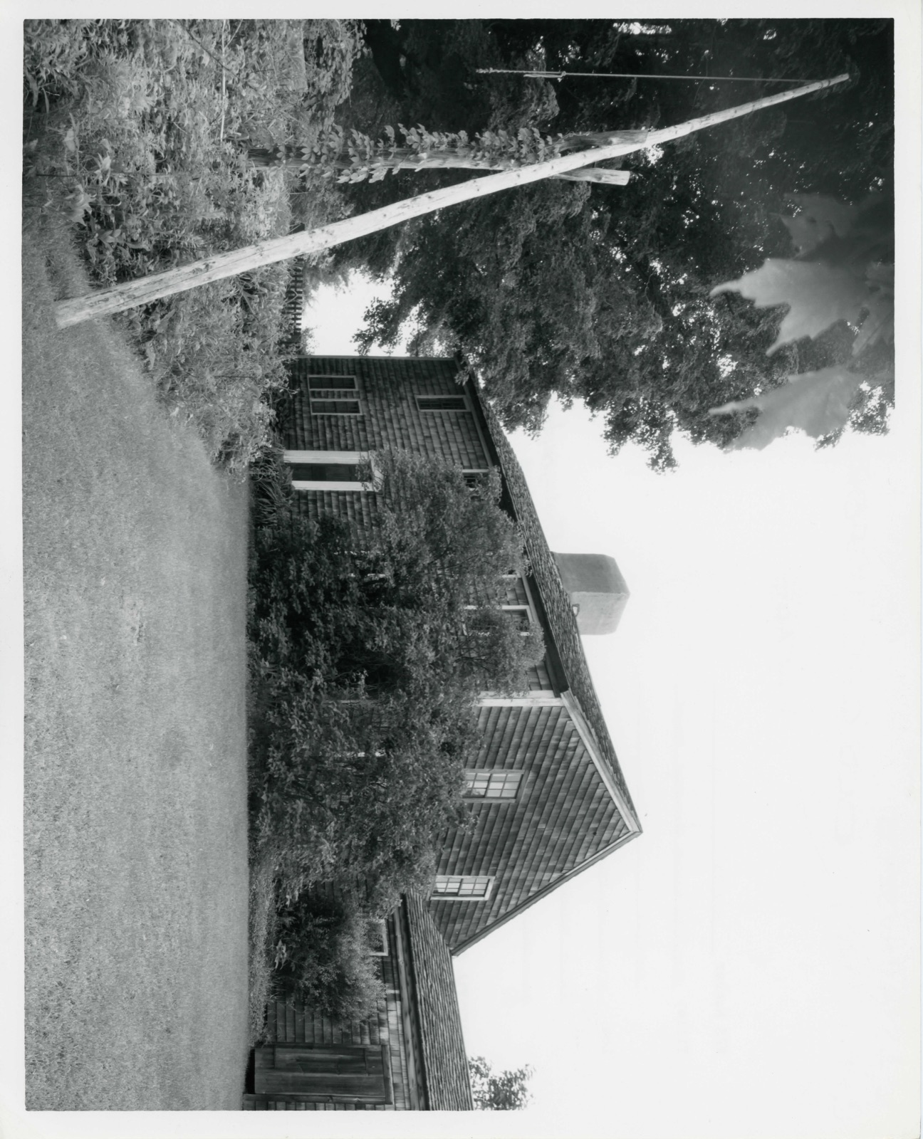
The Old Chelmsford Garrison House Complex is located on Garrison Road approximately one-tenth of a mile from Route 110. The Complex covers 1.4 acres and includes the Old Garrison House and the adjacent barn, the McCormick Craft Center and the Bartlett Educational Building. The main portion of the Garrison House was constructed c.1691. It was then a two-story clapboarded building, five bays wide with a gable roof and central chimney of unmortared stone. The original building contained two rooms on the ground floor and one room on the second floor; the remaining portion of the second floor was left unfinished. A lean-to was constructed at the rear of the house c. 1702, giving it its present saltbox appearance.
This addition contained two borning rooms, two kitchens with a center chimney of brick, and a pantry. At a later date, a shed was added to the eastern end of the lean-to. The Garrison House has now been covered with wooden shingles and the roof with hand-split wooden shakes. The six-over-six sash windows are reproductions. Located immediately to the west of the Garrison House is the barn, with an attached open shed and a slaughter-house, now converted for use as a care- taker's apartment. The exterior of this structure is a combination of board and batten and plain vertical planking; the roof is covered with black asphalt shingles. Located to the east of the Garrison House are the McCormick Craft Center and the Bartlett Educational Building.
The Craft Center, originally a henhouse, was converted to its present use in 1966; it is now a two-story clapboarded building with a gable roof.
The Old Chelmsford Garrison House is the oldest authenticated 17th century building in Chelmsford and the best example of the saltbox style in the town. Of the nineteen garrison houses which once stood in Chelmsford, this is the only one remaining. The original owner of this site was It. Thomas Adams, one of the nine children of Henry, the first American ancestor of the distinguished Adams family of Braintree and Quincy. Thomas was one of the original petitioners for the grant of land which became the town of Chelmsford; he served as a Selectman for 20 years. The Old Garrison Bouse was built c. 1691 (possibly earlier) by Tomas' son Pelatiah. It was then a two-story clapboard building with center chimney.
Stone and wood for construction of the house were taken from rock ledges and first growth forest on the property. In 1702, the house and land were deeded to Pelatiah's sons, Pelatiah, Jr. and Thomas. The "saltbox" addition at the rear (containing two borning rooms, two kitchens, and a pantry) dates from this period, when the two brothers and their families shared the L LJ In 1728, the Garrison House was purchased by Benjamin Heywood of Billerica; his descendants owned the property until 1922. The Old Chelmsford Garrison House Association was formed in 1959 to restore and preserve the house. The Association now maintains it and the adjacent buildings as a museum and educational center.
The Garrison House Complex includes three supporting buildings: the barn, which houses collections of farm implements and vehicles; the McCormick Craft Center, opened in 1966 to house the Garrison House Association's educational programs for local school groups; and the Bartlett Educational Building, moved to the present site in 1969 and used primarily exhibition space. RECEIVED APp 1973 NATIONAL REGISTER
Quoted from the National Register nomination
for reference 73000289, 21 pages, held by the National Archives in Record
Group 79. See the
catalogue record.
Listed places nearby
6 within 8 miles
Other National Register properties close
enough to walk or drive between, ordered by distance from this one. Both
positions come from the same geocoding pass that matched these properties
to their map sheets.
Listing record. National Park Service National Register of Historic Places, listed-properties dataset, current to 2026-05-22.
Map join. Address geocoded through the United States Census geocoder, then tested against the published boundary of every sheet in the USGS Historical Topographic Map Collection.
How this page is made. Listing fields come from federal records; map-sheet coverage is a labelled coordinate-to-boundary calculation, not a source-field claim.
Wildfire. Short, Karen C. 2022. Spatial wildfire occurrence data for the United States, 1992-2020 [FPA_FOD_20221014]. 6th Edition. Fort Collins, CO: Forest Service Research Data Archive. https://doi.org/10.2737/RDS-2013-0009.6 Collected with United States Government funding and usable without additional permissions or fees.
Specimens. Global Biodiversity Information Facility (GBIF), https://www.gbif.org/. Only records licensed CC0 or CC BY are used. Records licensed CC BY-NC are excluded because this site carries advertising. Images are checked individually and any whose licence is non-commercial, no-derivatives or unreadable is refused.
Mines and quarries. USGS Mineral Resources Data System (MRDS) https://mrdata.usgs.gov/mrds/ A work of the United States government, no copyright under 17 U.S.C. 105.
Storms. NOAA National Centers for Environmental Information, Storm Events Database https://www.ncei.noaa.gov/stormevents/ A work of the United States government, no copyright under 17 U.S.C. 105. Narratives are quoted verbatim from the National Weather Service report and are not edited or summarised.
 Block
Block