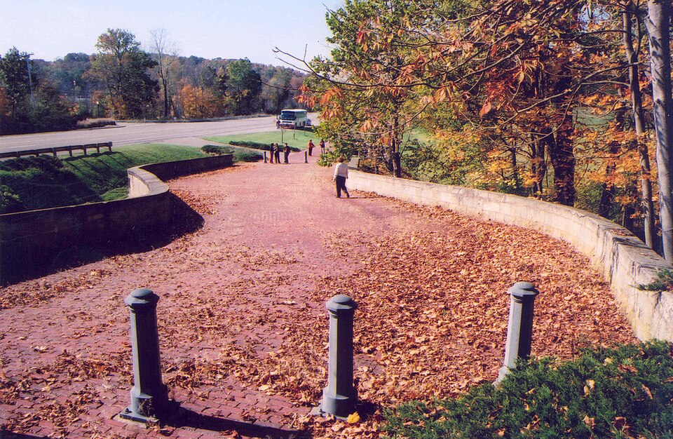
Built in 1828. Listed on the National Register of Historic Places in
1973. A historic map-sheet match is not published yet. The record needs a coordinate-quality review before it can be joined to a sheet boundary.
From the record
“"S" Bridge II is a historic S bridge near New Concord, Ohio, United States. A part of the National Road, the first federally-financed highway in the United States, it was built in 1828.”
Wikipedia article S Bridge II, CC BY-SA 4.0.
one of 70 National Register listings in Muskingum County · listed in 1973 · category: Structure · built in 1828, by Benjamin Henry Latrobe, II.
National Register reference number.73001513- the number the National Park Service assigned this property when it was listed, and the key its nomination file is catalogued under at the National Archives.
From 1803 to 1806, the Reasoners, Speers, Findleys, and Wilsons, from Pennsylvania, settled in the northeastern portion of the township, near the present site of New Concord. Henry Reasoner, having in the year 1804, entered the land on which the town now stands.
In the year 1804, Henry Reasoner, trom Pennsylvania, entered the southwest quarter of section one, which he sold to David Findley, in 1806, and, in 1828, Findley laid out the town of New Concord, along the line of the National Road.. .
Regional context, not property-specific
evidence. The
federal wildfire occurrence database
lists 29 fires within 5 miles of "S" Bridge II between
2011 and 2020, burning about 33 acres in total. 1 started naturally. None was recorded as arson.
Distance is straight-line from the map coordinates, so a fire counted
here may appear on a neighbouring settlement's page as well.
Reported cause
Fires
Debris and open burning
16
Missing data/not specified/undetermined
8
Equipment and vehicle use
2
Natural
1
Smoking
1
Power generation/transmission/distribution
1
The most recent of
them, most recent first, with the day each was reported and the service
that recorded it.
Regional context, not property-specific
evidence. Museums hold 1,063 specimens
collected within 10 miles of "S" Bridge II between 1908 and
1975: 770 Animalia, 290 Plantae, 3 Unrecorded. 12 distinct Species records are shown.
Collected by A. H. Wright, Adams, W., Adams, W. (William), Trautman, M. B. (Milton Bernard) et al. and others. Each is a
physical object with a catalogue
number, and each entry opens the museum's record. This is what was
collected and kept, not a survey of what lives here - nothing can be
concluded from a species being absent.
Regional context, not property-specific
evidence. The federal mineral resources record lists
2 workings within 5 miles of "S" Bridge II: 2 past producers.
None of them still produces. What was taken out: Limestone, General, Stone, Crushed/Broken. Distance is straight-line from the
map coordinates, so a quarry counted here may appear on a neighbouring
settlement's page as well.
Regional context, not property-specific
evidence. The National Weather Service names
New Concord, the town this property stands in, in 16 storm reports between 1995 and 2025: 11 thunderstorm wind, 4 hail, 1 flash flood.
No death or injury is recorded in these reports. Each account below is quoted exactly as the forecast office
filed it, from the NOAA Storm Events Database, and each date
opens the federal record of that event.
Rte 83 was flooded between Bloomfield and Otsego in the northeast part of Muskingum County, beginning at 632 AM EDT. By 835 AM EDT, there was flooding in Adamsville; and along State Rte 16 in Adams Mills. One house was surrounded by water in Otsego area.
No historic map-sheet match is published
for this property yet. That does not mean no map exists. This record needs
a coordinate-quality review before it can be joined to a sheet boundary.
Browse the county's mapped places while that work is
pending.
From the nomination file
1,880 words on record
When this property was proposed for the
National Register, someone wrote the case for it: what the building is,
and why it matters. That document is a federal record in the public domain.
It is quoted below word for word, never summarised. The text was read off the scanned case file by machine, so the
occasional stray character is the recogniser's and the 1970s
typewriter's.
Description of the property
Located just west of New Concord, Ohio at the point where U.S. Route 40 On either side of the arch, the floor of the bridge curves. On the east some repointing, the bridge is unaltered, and is in very good condition. curves at the approaches, cuts down the length of the arch needed to span the stream, and avoids steep grades and protects the back fill from in Washington, Hendrysburg, and Middleborne, Ohio, the road approaches have required a longer arch, more excavation and greater expense. DEC 1 3 1972 CONDITION DESCRIPTION REGISTER NATIONAL Ruins as part of the National Road in 1828.
It is one of several similar structures built in Ohio and Pennsylvania and crosses Fox Creek, is an "s' shaped masonry bridge which was constructed are constructedof cut stone ofvarying sizes in courses of1 foot (Check One) feet spans the creek along a line perpendicular to the flow of the stream. is slightly less than 22° north. The walls of the bridge and the vault or more. The floor is built of brick. Except for the brick floor and the stream at an angle. To bridge the stream at the center line would is approximately 140 feet long and 26 feet wide.
X Transportation Industry Department to build around the old structures instead of replacing Road S bridges extant in eastern Ohio. 1oad limits imposed. The S" Bridge II at New Concord is one of five original National Other PERIOD (Check One or More as Appropriate) masons, who were paid by the foot, knew that a curved structure would the beam structures, perfected by the railroads. The fact that they Art Some writers have suggested excellent design.The New Concord bridge is passable today with no force of water better than a straight span.Others have attributed the scurves to an attempt to keep surface water from draining down the bridges were Irish built and Englishmen planned",or that stone- they were built in such a peculiar shape. RECEIVED
Quoted from the National Register nomination
for reference 73001513, 13 pages, held by the National Archives in Record
Group 79. See the
catalogue record.
Listed places nearby
6 within 8 miles
Other National Register properties close
enough to walk or drive between, ordered by distance from this one. Both
positions come from the same geocoding pass that matched these properties
to their map sheets.
Listing record. National Park Service National Register of Historic Places, listed-properties dataset, current to 2026-05-22.
Map join. Address geocoded through the United States Census geocoder, then tested against the published boundary of every sheet in the USGS Historical Topographic Map Collection.
How this page is made. Listing fields come from federal records; map-sheet coverage is a labelled coordinate-to-boundary calculation, not a source-field claim.
Wildfire. Short, Karen C. 2022. Spatial wildfire occurrence data for the United States, 1992-2020 [FPA_FOD_20221014]. 6th Edition. Fort Collins, CO: Forest Service Research Data Archive. https://doi.org/10.2737/RDS-2013-0009.6 Collected with United States Government funding and usable without additional permissions or fees.
Specimens. Global Biodiversity Information Facility (GBIF), https://www.gbif.org/. Only records licensed CC0 or CC BY are used. Records licensed CC BY-NC are excluded because this site carries advertising. Images are checked individually and any whose licence is non-commercial, no-derivatives or unreadable is refused.
Mines and quarries. USGS Mineral Resources Data System (MRDS) https://mrdata.usgs.gov/mrds/ A work of the United States government, no copyright under 17 U.S.C. 105.
Storms. NOAA National Centers for Environmental Information, Storm Events Database https://www.ncei.noaa.gov/stormevents/ A work of the United States government, no copyright under 17 U.S.C. 105. Narratives are quoted verbatim from the National Weather Service report and are not edited or summarised.
 Block
Block