Listed on the National Register of Historic Places in
1983. A historic map-sheet match is not published yet. The record needs a coordinate-quality review before it can be joined to a sheet boundary.
From the record
“THE above-named gentleman ranks among the leading merchants of New Concord. In 1875 he located at the intersection of Main and Liberty streets, having purchased a half interest with the late Henry C.”
History of Muskingum County, Ohio, with Illustrations and Biographical Sketches of Prominent Men and Pioneers (1882). Machine-read text.
one of 70 National Register listings in Muskingum County · listed in 1983 · category: Building.
National Register reference number.83002017- the number the National Park Service assigned this property when it was listed, and the key its nomination file is catalogued under at the National Archives.
From 1803 to 1806, the Reasoners, Speers, Findleys, and Wilsons, from Pennsylvania, settled in the northeastern portion of the township, near the present site of New Concord. Henry Reasoner, having in the year 1804, entered the land on which the town now stands.
In the year 1804, Henry Reasoner, trom Pennsylvania, entered the southwest quarter of section one, which he sold to David Findley, in 1806, and, in 1828, Findley laid out the town of New Concord, along the line of the National Road.. .
Regional context, not property-specific
evidence. The
federal wildfire occurrence database
lists 28 fires within 5 miles of Stormont, David, House between
2011 and 2020, burning about 31 acres in total. 1 started naturally. None was recorded as arson.
Distance is straight-line from the map coordinates, so a fire counted
here may appear on a neighbouring settlement's page as well.
Reported cause
Fires
Debris and open burning
15
Missing data/not specified/undetermined
8
Equipment and vehicle use
2
Natural
1
Smoking
1
Power generation/transmission/distribution
1
The most recent of
them, most recent first, with the day each was reported and the service
that recorded it.
Regional context, not property-specific
evidence. Museums hold 1,059 specimens
collected within 10 miles of Stormont, David, House between 1908 and
1975: 767 Animalia, 289 Plantae, 3 Unrecorded. 12 distinct Species records are shown.
Collected by A. H. Wright, Adams, W., Adams, W. (William), Trautman, M. B. (Milton Bernard) et al. and others. Each is a
physical object with a catalogue
number, and each entry opens the museum's record. This is what was
collected and kept, not a survey of what lives here - nothing can be
concluded from a species being absent.
Regional context, not property-specific
evidence. The federal mineral resources record lists
2 workings within 5 miles of Stormont, David, House: 2 past producers.
None of them still produces. What was taken out: Limestone, General, Stone, Crushed/Broken. Distance is straight-line from the
map coordinates, so a quarry counted here may appear on a neighbouring
settlement's page as well.
Regional context, not property-specific
evidence. The National Weather Service names
New Concord, the town this property stands in, in 16 storm reports between 1995 and 2025: 11 thunderstorm wind, 4 hail, 1 flash flood.
No death or injury is recorded in these reports. Each account below is quoted exactly as the forecast office
filed it, from the NOAA Storm Events Database, and each date
opens the federal record of that event.
Rte 83 was flooded between Bloomfield and Otsego in the northeast part of Muskingum County, beginning at 632 AM EDT. By 835 AM EDT, there was flooding in Adamsville; and along State Rte 16 in Adams Mills. One house was surrounded by water in Otsego area.
No historic map-sheet match is published
for this property yet. That does not mean no map exists. This record needs
a coordinate-quality review before it can be joined to a sheet boundary.
Browse the county's mapped places while that work is
pending.
From the nomination file
1,447 words on record
When this property was proposed for the
National Register, someone wrote the case for it: what the building is,
and why it matters. That document is a federal record in the public domain.
It is quoted below word for word, never summarised. The text was read off the scanned case file by machine, so the
occasional stray character is the recogniser's and the 1970s
typewriter's.
Description of the property
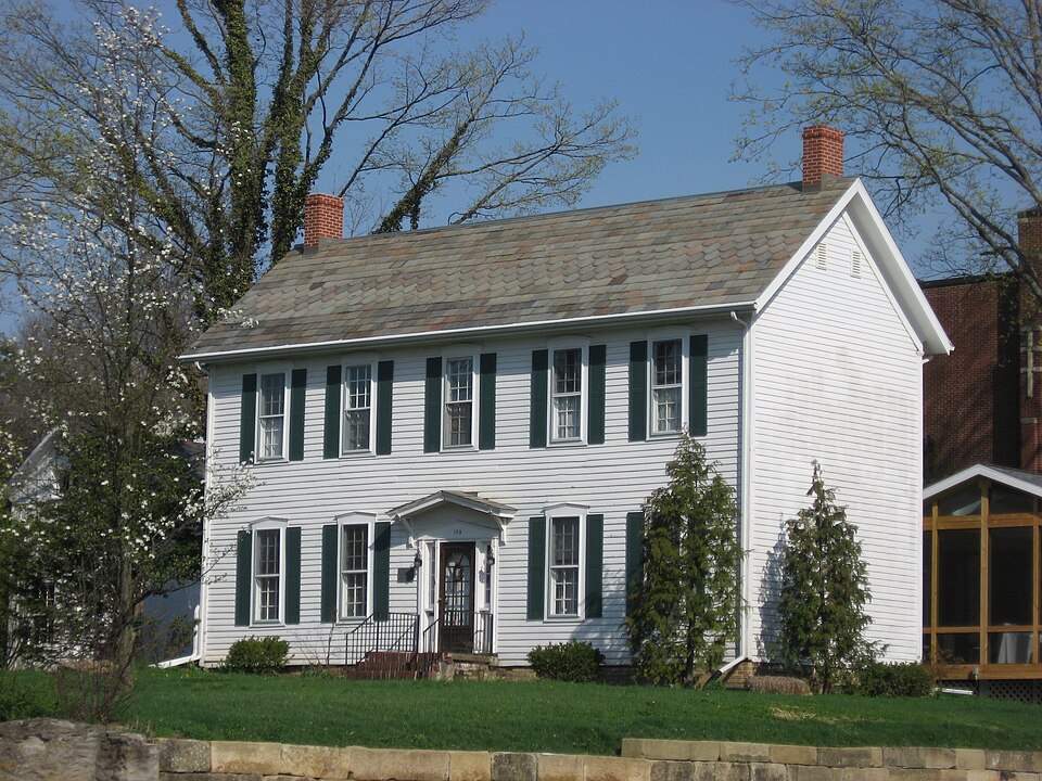
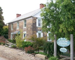
that this was used as a summer kitchen and perhaps a wash house. There was originally a large barn located to the north of the house; the only remain- - good .ruins The David Stormont House is a 2-story wood frame structure with a gable roof, set on a Fronting on the old National Road, the present facade is articulated by a 5-bay roof, located ca. 20' west of the house. Complate with a fireplace, it seems likely fair stone foundation.Local historical sources have reported that the rear section The property sits on Main Street in the heart of the small commercial district of cornerboards and the multicolored slate roof which no doubt replaced an original the village.Stormont Street lies to the east; across Stormont Street sat Stormont roof of wood shakes.
Areas of Significance-Check and justify below - archeology-historic _ conservation _ literature .military . social/ X 1800-1899 - philosophy _theater - politics/government _ transportation - other (specify) ca. 1835 characterized as a midwestern "I" house, a folk house type which was first documented part of the "I" house defines the type. In addition to its being an early representative of this form in the area, the Stormont House is the finest pre- for expansion. New Concord, however, never developed the fine, high-style National town (ref. Old Washington Historic District, N. R.
5-29-75, and Morristown Historic built plain, unadorned dwellings of log and wood frame, as well as simple store The house was the home of David Stormont (1800-1891), a native of County Antrim, Ireland daughter-in-law, Maria, occupied the house until 1930. In addition to the house, the large board-and-batten outbuilding (12'x36') is the only and this is the only structure in town of board-and-batten construction in town.
(in one paragraph) house was the seat of his 80-acre tract, which stretched north and west from the house. invention The Stormont House is simply the best that this village has from this period in Road architecture that typifies towns in eastern Ohio such as Old Washington and Morris- in the case of the Stormont House--the I"house also has a central hallway with an - archeology-prehistoric - community planning - landscape architecture _ - religion X architecture Concord's finest ante-bellum residence, as well as for its direct historical associ- ation with one of the area's first settlers. Architecturally, the house can be and is defined by a 2-story plan, one room deep and two rooms across. Generally--and (later the Reformed) Presbyterian Church in June, 1821.
His family, including his 1600-1699 art Period The David Stormont House is nominated for its significance as the village of New structure of its kind in the village.Most dependencies have been distroyed in New Concord, by cultural geographer Fred Kniffen in the 1930s.This house type is the most It is known that he took part in the first communion service held by the Salt Creek 9.
Quoted from the National Register nomination
for reference 83002017, 10 pages, held by the National Archives in Record
Group 79. See the
catalogue record.
Listed places nearby
6 within 8 miles
Other National Register properties close
enough to walk or drive between, ordered by distance from this one. Both
positions come from the same geocoding pass that matched these properties
to their map sheets.
Listing record. National Park Service National Register of Historic Places, listed-properties dataset, current to 2026-05-22.
Map join. Address geocoded through the United States Census geocoder, then tested against the published boundary of every sheet in the USGS Historical Topographic Map Collection.
How this page is made. Listing fields come from federal records; map-sheet coverage is a labelled coordinate-to-boundary calculation, not a source-field claim.
Wildfire. Short, Karen C. 2022. Spatial wildfire occurrence data for the United States, 1992-2020 [FPA_FOD_20221014]. 6th Edition. Fort Collins, CO: Forest Service Research Data Archive. https://doi.org/10.2737/RDS-2013-0009.6 Collected with United States Government funding and usable without additional permissions or fees.
Specimens. Global Biodiversity Information Facility (GBIF), https://www.gbif.org/. Only records licensed CC0 or CC BY are used. Records licensed CC BY-NC are excluded because this site carries advertising. Images are checked individually and any whose licence is non-commercial, no-derivatives or unreadable is refused.
Mines and quarries. USGS Mineral Resources Data System (MRDS) https://mrdata.usgs.gov/mrds/ A work of the United States government, no copyright under 17 U.S.C. 105.
Storms. NOAA National Centers for Environmental Information, Storm Events Database https://www.ncei.noaa.gov/stormevents/ A work of the United States government, no copyright under 17 U.S.C. 105. Narratives are quoted verbatim from the National Weather Service report and are not edited or summarised.
 Block
Block