Listed on the National Register of Historic Places in
1976. A historic map-sheet match is not published yet. The record needs a coordinate-quality review before it can be joined to a sheet boundary.
From the record
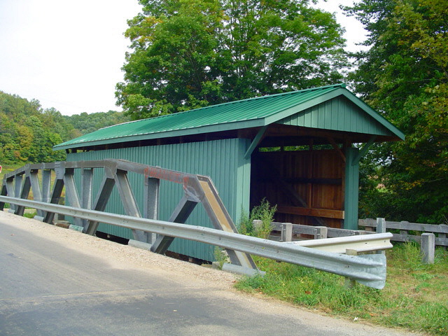
“Olive Road Covered Bridge is a historic covered bridge in Vinton County, Ohio, United States. Located northeast of Allensville, the bridge carries Mt.”
Wikipedia article Mt. Olive Road Covered Bridge, CC BY-SA 4.0.
one of 6 National Register listings in Vinton County · listed in 1976 · category: Structure.
National Register reference number.76001538- the number the National Park Service assigned this property when it was listed, and the key its nomination file is catalogued under at the National Archives.
Fires near this property
18 since 2006
Regional context, not property-specific
evidence. The
federal wildfire occurrence database
lists 18 fires within 5 miles of Mt. Olive Road Covered Bridge between
2006 and 2015, burning about 317 acres in total. None started naturally. 2 were recorded as arson.
Distance is straight-line from the map coordinates, so a fire counted
here may appear on a neighbouring settlement's page as well.
Reported cause
Fires
Debris and open burning
13
Arson/incendiarism
2
Missing data/not specified/undetermined
2
Power generation/transmission/distribution
1
The most recent of
them, most recent first, with the day each was reported and the service
that recorded it.
Regional context, not property-specific
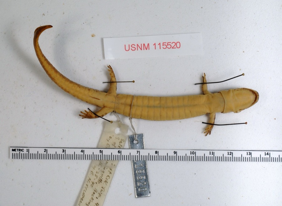
evidence. Museums hold 1,685 specimens
collected within 10 miles of Mt. Olive Road Covered Bridge between 1878 and
1975: 1,622 Animalia, 33 Plantae, 29 Fungi, 1 Unrecorded. 12 distinct Species records are shown.
Collected by A. Spreitzer, A. Spreitzer et al., Adams, K.; Bitner, E. and others. Each is a
physical object with a catalogue
number, and each entry opens the museum's record. This is what was
collected and kept, not a survey of what lives here - nothing can be
concluded from a species being absent.
Regional context, not property-specific
evidence. The National Weather Service names
Allensville, the town this property stands in, in 19 storm reports between 1998 and 2025: 11 thunderstorm wind, 5 flood, 2 flash flood, 1 hail.
No death or injury is recorded in these reports. Each account below is quoted exactly as the forecast office
filed it, from the NOAA Storm Events Database, and each date
opens the federal record of that event.
Multiple roads across central Vinton County were closed due to flooding. This included portions of US 50 near McArthur and also near the intersection of US 50 and Carpenter Road at Allensville.
US Route 50 was closed near Allensville due to flooding along Middle Fork Salt Creek and Riley Run. Up to 3 feet of water was flowing across the roadway at the height of the flooding.
A tree was blown down onto Carpenter Road near Allensville. As the storms progressed eastward, strong winds caused numerous downed trees along Route 160.
No historic map-sheet match is published
for this property yet. That does not mean no map exists. This record needs
a coordinate-quality review before it can be joined to a sheet boundary.
Browse the county's mapped places while that work is
pending.
From the nomination file
1,960 words on record
When this property was proposed for the
National Register, someone wrote the case for it: what the building is,
and why it matters. That document is a federal record in the public domain.
It is quoted below word for word, never summarised. The text was read off the scanned case file by machine, so the
occasional stray character is the recogniser's and the 1970s
typewriter's.
Description of the property
Known as the Mt. Olive Road Covered Bridge, this old bridge was built in 1875 1low of the stream is against the east abutment. CONDITION DATE UNEXPOSED EXCELLENT UNALTERED RUINS DETERIORATED GOOD ment forming b oth floor beams and lower chords.The west abutment is the origi- tals. The structure under consideration is a one-span wooden truss covered bridge spanning pillars for piers under the west joist.Steel I-beams rgn from abutment to abut- layer floor laid crosswise, with raised runners. The Mt. Olive Road Covered Bridge is very simply built.All diagonals are9 nal stone and the east abutment is the original stone with a concrete base. The mile northeast of Allensville in Vinton County, Ohio.This old span has vertical, long enough, the early builders developed the multiple kingpost.
for a longer base for the truss, thus making it possible to bridge wider streams 9n. Steel channels of varying heights have been applied to the outside of these using the simple queenpost truss plan, a variation of the simple kingpost.In the This bridge measures 5oi6" from portal to portal, which in this case, includes overhang of about 4t'.Steel channels have also been added to the truss diag- horizontal crosspiece.This is not a part of the top chord of the bridge, but.a the middle fork of Salt Creek on Mt.Olive Road in Jackson Township section 7, one are not covered by any extension of the siding as is usual with most of our CHECK ONE the entire truss, plus about a 4t' overhang on each end.
It is ll'2" wide over- - MOVED queenpost truss, there are two triangular truss members separated at the top by & separate piece, running parallel to the top chord.
Mt. Olive Road Covered Bridge. due him, deducting $4. for two iron rods omitted. The old lit- Olive Road Covered Bridge has now given the area a century of faith- Iul service. 1700-1799 INVENTION ARCHEOLOGY-HISTORIC RELIGION SIGNIFICANCE SCIENCE CONSERVATION EDUCATION PERIOD THEATER COMMERCE COMMUNICATIONS EXPLORATION/SETTLEMENT ARCHITECTURE George Washington Pilcher BUILDER/ARCHITECT ART POLITICS/GOVERNMENT SCULPTURE Historic XENGINEERING INDUSTRY LITERATURE northeast on now impassable roads and down over the ridge in an easterly direc- foundations for Cutler Hall at Ohio University at Athens.One unconfirmed story SOCIAL/HUMANITARIAN "Buffalo Trail".
The contract for this bridge was originally awarded to a John Calvin for $6.per _1600-1699 well-known Vinton County stone mason and builder.Mr. Pilcher was a Civil War came east from Chillicothe to Allensville and then northeast to the valley which veteran and was quite active as an itinerant lay preacher.He built the founda- staff Bridge. Today, the bridge is known only as the Mt. Olive Road Bridge. Both bridge and road take their names from the nearby Mt.Olive Church.The Mr.Pilcher obviously favored the simple Queenpost truss plan which he used here, lineal foot, and the masonry work was to be done by Mr.Pilcher.For some un- The Mt.Olive Road Covered Bridge was built in 1875 by George Washington Pilcher, known reason, Mr.Calvin made arrangements for Mr.Pilcher to do all of the work.
Quoted from the National Register nomination
for reference 76001538, 15 pages, held by the National Archives in Record
Group 79. See the
catalogue record.
Listed places nearby
1 within 8 miles
Other National Register properties close
enough to walk or drive between, ordered by distance from this one. Both
positions come from the same geocoding pass that matched these properties
to their map sheets.
Listing record. National Park Service National Register of Historic Places, listed-properties dataset, current to 2026-05-22.
Map join. Address geocoded through the United States Census geocoder, then tested against the published boundary of every sheet in the USGS Historical Topographic Map Collection.
How this page is made. Listing fields come from federal records; map-sheet coverage is a labelled coordinate-to-boundary calculation, not a source-field claim.
Wildfire. Short, Karen C. 2022. Spatial wildfire occurrence data for the United States, 1992-2020 [FPA_FOD_20221014]. 6th Edition. Fort Collins, CO: Forest Service Research Data Archive. https://doi.org/10.2737/RDS-2013-0009.6 Collected with United States Government funding and usable without additional permissions or fees.
Specimens. Global Biodiversity Information Facility (GBIF), https://www.gbif.org/. Only records licensed CC0 or CC BY are used. Records licensed CC BY-NC are excluded because this site carries advertising. Images are checked individually and any whose licence is non-commercial, no-derivatives or unreadable is refused.
Storms. NOAA National Centers for Environmental Information, Storm Events Database https://www.ncei.noaa.gov/stormevents/ A work of the United States government, no copyright under 17 U.S.C. 105. Narratives are quoted verbatim from the National Weather Service report and are not edited or summarised.
 Block
Block