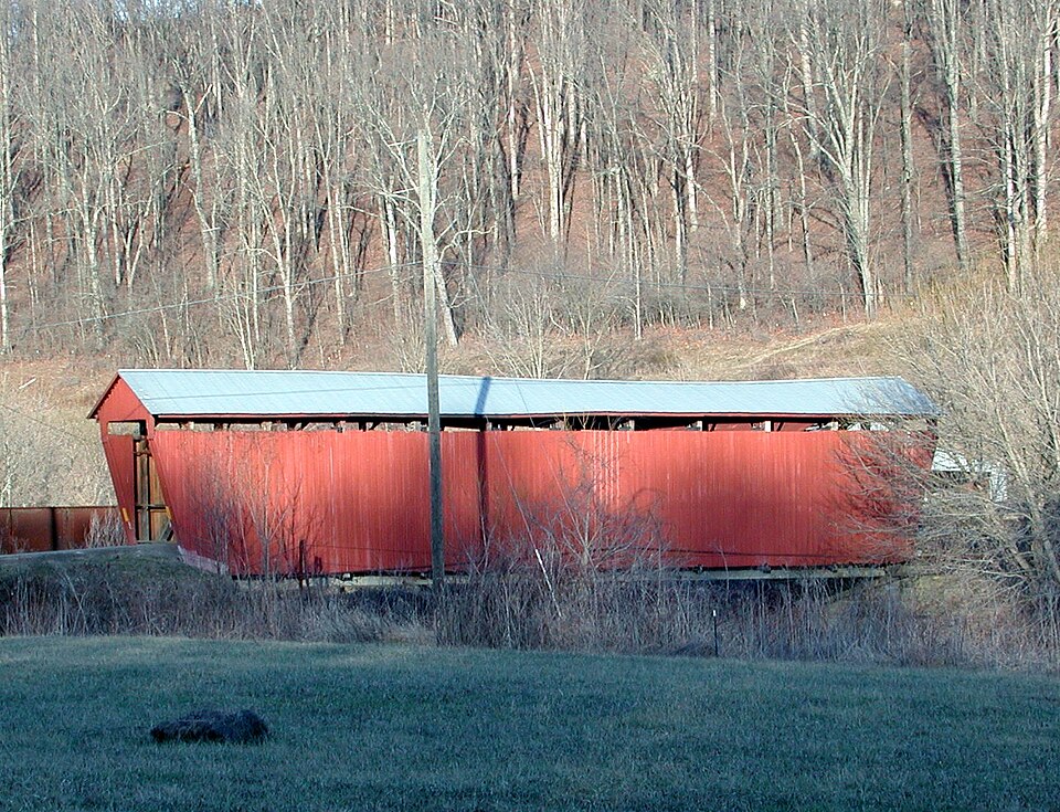
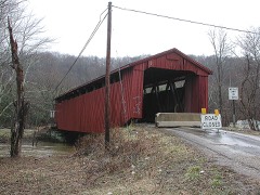
Built in 1876. Listed on the National Register of Historic Places in
1977. A historic map-sheet match is not published yet. The record needs a coordinate-quality review before it can be joined to a sheet boundary.
From the record
“The Palos Covered Bridge, in Athens County, Ohio near Glouster, was listed on the National Register of Historic Places in 1977. It is a multiple kingpost truss covered bridge.”
Wikipedia article Palos Covered Bridge, CC BY-SA 4.0.
one of 19 National Register listings in Athens County · listed in 1977 · category: Structure · built in 1876 · one of 1 National Historic Landmarks in Athens County.
National Register reference number.77001041- the number the National Park Service assigned this property when it was listed, and the key its nomination file is catalogued under at the National Archives.
Fires near this property
35 since 2006
Regional context, not property-specific
evidence. The
federal wildfire occurrence database
lists 35 fires within 5 miles of Palos Covered Bridge between
2006 and 2020, burning about 41 acres in total. None started naturally. 1 was recorded as arson.
Distance is straight-line from the map coordinates, so a fire counted
here may appear on a neighbouring settlement's page as well.
Reported cause
Fires
Debris and open burning
19
Power generation/transmission/distribution
4
Missing data/not specified/undetermined
4
Recreation and ceremony
4
Smoking
2
Equipment and vehicle use
1
Arson/incendiarism
1
The most recent of
them, most recent first, with the day each was reported and the service
that recorded it.
Regional context, not property-specific
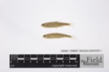
evidence. Museums hold 62 specimens
collected within 10 miles of Palos Covered Bridge between 1898 and
1972: 51 Animalia, 9 Plantae, 2 Fungi. 12 distinct Species records are shown.
Collected by Bolen, H. (Harold), Collector(s): John W. Meldrim, DAVID M SEVER and others. Each is a
physical object with a catalogue
number, and each entry opens the museum's record. This is what was
collected and kept, not a survey of what lives here - nothing can be
concluded from a species being absent.
Regional context, not property-specific
evidence. The National Weather Service names
Glouster, the town this property stands in, in 14 storm reports between 1994 and 2026: 7 thunderstorm wind, 5 flood, 2 hail.
No death or injury is recorded in these reports. Each account below is quoted exactly as the forecast office
filed it, from the NOAA Storm Events Database, and each date
opens the federal record of that event.
Late on the 9th, Sunday Creek crested at Glouster between 15 and 16 feet. ||Route 13 north of Glouster and its intersection with Route 329 in Trimble were flooded and closed.
Sunday Creek at Glouster rose above a bankfull level of 13 feet on the morning of March 5th, then continued to rise to a crest near 15.1 feet that evening. The creek then slowly receded back below bankfull level the next morning. Flooding took place in many locations, including the Trimble High School parking lot, Center Street and Route 13 near Congress Street in Trimble, Palmer Street in Jacksonville, and West Main Street, portions of Oakdale Road, South Town Street, Kennedy Road, and Glouster Memorial Park in Glouster.
The Glouster High School parking lot, nearby ballfields, and South Town Street were inundated with high water. Flooding also closed State Route 329, and State Route 13 from State Route 78 to Taylor Ridge Road.
No historic map-sheet match is published
for this property yet. That does not mean no map exists. This record needs
a coordinate-quality review before it can be joined to a sheet boundary.
Browse the county's mapped places while that work is
pending.
From the nomination file
1,446 words on record
When this property was proposed for the
National Register, someone wrote the case for it: what the building is,
and why it matters. That document is a federal record in the public domain.
It is quoted below word for word, never summarised. The text was read off the scanned case file by machine, so the
occasional stray character is the recogniser's and the 1970s
typewriter's.
Description of the property
on township road 347 just east of SR 13, one mile north of Glouster, Ohio, This old structure is known as the Palos Bridge and was built on the multiple multiple kingpost is a development of the simple, single kingpost where a DATE MOVED FAIR The structure under consideration is a one-span wooden truss covered bridge CONDITION The abutments are the original cut-stone.The siding was replaced in 1975. The old Palos Covered Bridge is painted a deep red on both siding and portals. truss and it makes use of the triangular form where the truss upright or verti- tions are undoubtedly a later addition and consist of vertical iron rods on roof, cut-stone abutments and slightly projected portals.
the kingposts near the ends of the bridge where the tension is greatest and CHECK ONE wooden counterbraces added in to make X panels in the center of the bridge _DETERIORATED the length of the bridge The present metal roof is a replacement for one which blew off in a windstorm in 1960.In 197l, the county placed a steel substructure inder the bridge. _UNEXPOSED _UNALTERED of the structure is ll'3".Height of the trusses is l2'7" and the over- ATAO X ALTERED cal member is in tension, and the truss diagonals are in compression.
The The Palos Briage isa l0 panel modified multiple kingpost.These modifica- longer bridge was needed to span a stream than could be built with just a where compression is greater.The length of the bridge is 8l' overall with spanning the east fork of Sunday Breek in section ll of Trimble Township, Athens County.This old span has vertical, high-boarded siding, a metal simple kingpost. This was the most common bridge truss built here in Ohio. a clear span of 72'10.The roadway width is12'1# and the overall width -RUINS AREAS OF
Statement of significance
for many years now. The name Palos, a Greek word, comes from the tiny cross- proximity to SR 13 and Burr Oak Lake, this old covered bridge is well-known We have no building date on this old bridge, but we do know that the road it attractive bridge with its deep red paint on both siding and portals. It still 1500-1599 1700-1799 1400-1499 COMMERCE ECONOMICS ARCHEOLOGY-HISTORIC 1600-1699 PERIOD ART BUILDER/ARCHITECT ARCHITECTURE SIGNIFICANCE 1900- THEATER SCULPTURE INVENTION AGRICULTURE Historic MUSIC _EXPLORATION/SETTLEMENT built on what was once the most common bridge truss plan in Ohio. The bridge LITERATURE been made to these trusses over the years to strengthen them. serves daily traffic and is a visual reminder of the past. MILITARY that year.
_COMMUNICATIONS state and only the name remains for most of them today.Because of its close The trin Palos Covered Bridge has been a landmark for travelers along SR 13 is almost non-existant today, but it is still marked on the county maps.No INDUSTRY _RELIGION _CONSERVATION _PHILOSOPHY 188ols.It is unfortunate that the early history of this bridge is lost to many of these tiny Whistle Stops on the railroads in the early days of our one today seems to know why the community was given that name. There were to tourists.
The Athens County Engineer gives this bridge excellent maintenance.It is an is very interesting to us today because of the engineering additions that have serves was not in existance in l875 as it is not shown in the county atlas for Therefore, it is probably a product of the late 1870's or early us today, but we know that it is an authentic old timber truss covered bridge, _COMMUNITY PLANNING roads community of that name about a mile to the north of the bridge.Palos -LAW.
Quoted from the National Register nomination
for reference 77001041, 11 pages, held by the National Archives in Record
Group 79. See the
catalogue record.
Listed places nearby
2 within 8 miles
Other National Register properties close
enough to walk or drive between, ordered by distance from this one. Both
positions come from the same geocoding pass that matched these properties
to their map sheets.
Listing record. National Park Service National Register of Historic Places, listed-properties dataset, current to 2026-05-22.
Map join. Address geocoded through the United States Census geocoder, then tested against the published boundary of every sheet in the USGS Historical Topographic Map Collection.
How this page is made. Listing fields come from federal records; map-sheet coverage is a labelled coordinate-to-boundary calculation, not a source-field claim.
Wildfire. Short, Karen C. 2022. Spatial wildfire occurrence data for the United States, 1992-2020 [FPA_FOD_20221014]. 6th Edition. Fort Collins, CO: Forest Service Research Data Archive. https://doi.org/10.2737/RDS-2013-0009.6 Collected with United States Government funding and usable without additional permissions or fees.
Specimens. Global Biodiversity Information Facility (GBIF), https://www.gbif.org/. Only records licensed CC0 or CC BY are used. Records licensed CC BY-NC are excluded because this site carries advertising. Images are checked individually and any whose licence is non-commercial, no-derivatives or unreadable is refused.
Storms. NOAA National Centers for Environmental Information, Storm Events Database https://www.ncei.noaa.gov/stormevents/ A work of the United States government, no copyright under 17 U.S.C. 105. Narratives are quoted verbatim from the National Weather Service report and are not edited or summarised.
 Block
Block