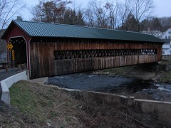
Built in 1845. Listed on the National Register of Historic Places in
1982. A historic map-sheet match is not published yet. The record needs a coordinate-quality review before it can be joined to a sheet boundary.
From the record
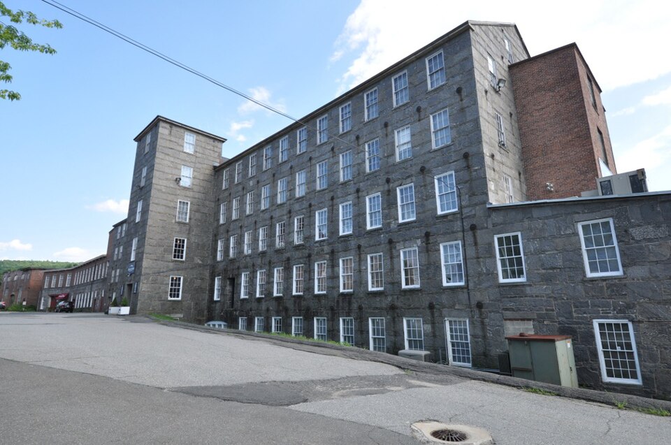
“Otis Company Mill No. 1 is a historic mill on E. Main Street in Ware, Massachusetts, United States.”
Wikipedia article Otis Company Mill No. 1, CC BY-SA 4.0.
one of 32 National Register listings in Hampshire County · listed in 1982 · category: Building · built in 1845.
National Register reference number.82001909- the number the National Park Service assigned this property when it was listed, and the key its nomination file is catalogued under at the National Archives.
The eastern band of schists leaves the county at the south line of Orange, and, traversing Worcester County for a long distance, reenters the area of the map in Ware and crosses Palmer and Monson. The fourfold division of the schists, which has been persistent over so large an area, and which seems to be somewhat less distinct at the beginning of this band in Orange, here fails entirely. It is reduced to a twofold division of amphibolites below, resting directly upon the Monson gneiss, and a great volume of fibrolitic mica-schists, the lower portion of which may represent the whetstone-schist, but in which no persistent lithological distinctions can be established.
Mica-schist from Ware. In the bluff near the contact of mica-schist on hornblende-schist, 175 rods southwest of B. Bond's house, is seen a black, fine-grained schist with wavy, shining lamination surface, which may almost be called an argillite, with rarely deep-red garnets and large porphyi-itic spots of white feldspar.
Regional context, not property-specific
evidence. The
federal wildfire occurrence database
lists 34 fires within 5 miles of Otis Company Mill No. 1 between
2015 and 2020, burning about 17 acres in total. 7 started naturally. None was recorded as arson.
Distance is straight-line from the map coordinates, so a fire counted
here may appear on a neighbouring settlement's page as well.
Reported cause
Fires
Equipment and vehicle use
10
Missing data/not specified/undetermined
9
Natural
7
Recreation and ceremony
4
Debris and open burning
3
Smoking
1
The most recent of
them, most recent first, with the day each was reported and the service
that recorded it.
Regional context, not property-specific
evidence. Museums hold 418 specimens
collected within 10 miles of Otis Company Mill No. 1 between 1857 and
1975: 224 Animalia, 123 Plantae, 70 Fungi, 1 Chromista. 12 distinct Species records are shown.
Collected by A. C. Gibson, A. Lavallee, A. P. Chute and others. Each is a
physical object with a catalogue
number, and each entry opens the museum's record. This is what was
collected and kept, not a survey of what lives here - nothing can be
concluded from a species being absent.
Regional context, not property-specific
evidence. The federal mineral resources record lists
6 workings within 5 miles of Otis Company Mill No. 1: 4 past producers, 1 producer, 1 plant.
2 still produce. What was taken out: Sand and Gravel, Construction. Distance is straight-line from the
map coordinates, so a quarry counted here may appear on a neighbouring
settlement's page as well.
Regional context, not property-specific
evidence. The National Weather Service names
Ware, the town this property stands in, in 28 storm reports between 1995 and 2025: 18 thunderstorm wind, 4 flood, 3 hail, 2 lightning.
The reports record 3 injuries. Each account below is quoted exactly as the forecast office
filed it, from the NOAA Storm Events Database, and each date
opens the federal record of that event.
Lightning struck the medical office building on the campus of Baystate Mary Lane Hospital in Ware, blowing out the building's electrical panel. In addition, three people who were on the telephone at the time of the strike reported feeling numbness and a tingling in their arms. All three walked over to the hospital to be checked out and were fine.
In Amherst, a newly paved driveway washed out onto Bay Road. There was substantial damage on the University of Massachusetts-Amherst campus. In the Morrill Science Center IV, a transformer blew up when one foot of water flooded the room where it is housed. Two to six feet of water flooded portions of the Murray D. Lincoln campus center damaging meeting rooms, offices, and one escalator. Finally, in the Boyden Gymnasium, floodwaters caused a concrete gym floor to heave. In Ware, Anderson Road was flooded out, closing the road.
Numerous trees and wires were downed in Ware, including along Gilbertville and Campbell Roads. Six other roads were also closed due to the downed trees and wires.
At 1018 AM EST, an amateur radio operator reported flooding related to an ice jam on the Ware River in Ware. The Ware Airport was flooded, and a portion of Church Street was closed.
One lane of Route 9, starting at the Belchertown line, was closed due to flooding. In addition, several small streams and rivers went into flood during this time. No damage was reported with this flooding. These rivers included: the West branch of the Westfield River at Huntington, the Mill River, and the Connecticut River at Northampton.
No historic map-sheet match is published
for this property yet. That does not mean no map exists. This record needs
a coordinate-quality review before it can be joined to a sheet boundary.
Browse the county's mapped places while that work is
pending.
From the nomination file
3,015 words on record
When this property was proposed for the
National Register, someone wrote the case for it: what the building is,
and why it matters. That document is a federal record in the public domain.
It is quoted below word for word, never summarised. The text was read off the scanned case file by machine, so the
occasional stray character is the recogniser's and the 1970s
typewriter's.
Description of the property
The Old Stone Mill (Otis Company Mill #1) is a five story granite structure which sits amidst a cluster of nineteenth century red brick textile mills. It faces East Main Street to the north and abuts the Ware River along the building's entire southern facade. Due to a difference in ground elevation, only four of the five stories are visible from the street (north) side. The building's design clearly reflects its intended industrial function as well as mid- nineteenth century building technology. The original building is a 48' wide x 200' long rectangle with load bearing walls. Cast iron tie rods which were used to stabilize major interior floor beams form a linear pattern on the exterior wall surface.
Numerous 6'x3' Hhon song the noren ste o the buiftin, fr m aiy vertica a me u tne origtcal Locally quarried granite is the primary building material. The fieldstone foundation is veneered with coursed granite ashlar; the load bearing walls are made of thick granite blocks as is the five story north stair tower; the window lintels and sills are also of granite. The building's lines, proportions, monumental scale, massive cut stone walls, regularly spaced large paned six over six double hung windows, pitched roof, and the granite returns at the gable ends reflect the Greek Revival style which was very popular in Ware at the time of the building's construction in 1845.
The date "1845"' is chiseled into a stone above the entrance of the main stair tower on the north side and is corraborated by docu- mentary evidence. There have been a number of additions to the original building. The two story granite annex on the west end apparently dates to 1854. It projects 20' from the main building and is 36' wide.
(in one paragraph) Builder/Architect probably Joseph Brown The Otis Mill possesses integrity of location, design, setting, materials, and workman- Architecturally, this building is an outstanding example of an early 19th century textile mill of the Rhode Island type and so meets criterion C. This type of mill was modeled rather closely after its late 18th century English counterpart. As New England's fledgling textile industry of that era played a vanguard role in transforming the U.S. into an industrial nation, the significance of this type of mill can hardly be understated. Otis Mill #1 is one of the last remaining granite textile mills of this early (pre-turbine) period in western Massachusetts.1 For all of these reasons the Otis Mill also meets criterion A.
The only other survivors are Thorndike #1 and #2 in Palmer. The Thorndike mills have been severely altered; a story added, roofs flattened (not uncommon), most windows replaced with cinderblocks, and prolonged neglect has run its ugly course. The exceptional condition of Otis Mill #1 further enhances its significance. n a local level, Otis Mill #1 is significant in a number of areas. The mills determined the site of Ware's major settlement, and even its layout to an extent, for the company originally owned most of the village. The mills were the keystone upon which the local economy rested. Ware's fortunes rose and fell with those of the Otis Company.
mill workers were originally paid only twice a year (in credit redeemable at the Company Store), said mhg mel witn thoe ot cor ueanice ar the conpaly store enjoyed a uniquely advantageous position in the world company likewise played a major role in town politics, education, housing, religion, and even recreation.
Quoted from the National Register nomination
for reference 82001909, 11 pages, held by the National Archives in Record
Group 79. See the
catalogue record.
Listed places nearby
2 within 8 miles
Other National Register properties close
enough to walk or drive between, ordered by distance from this one. Both
positions come from the same geocoding pass that matched these properties
to their map sheets.
Listing record. National Park Service National Register of Historic Places, listed-properties dataset, current to 2026-05-22.
Map join. Address geocoded through the United States Census geocoder, then tested against the published boundary of every sheet in the USGS Historical Topographic Map Collection.
How this page is made. Listing fields come from federal records; map-sheet coverage is a labelled coordinate-to-boundary calculation, not a source-field claim.
Wildfire. Short, Karen C. 2022. Spatial wildfire occurrence data for the United States, 1992-2020 [FPA_FOD_20221014]. 6th Edition. Fort Collins, CO: Forest Service Research Data Archive. https://doi.org/10.2737/RDS-2013-0009.6 Collected with United States Government funding and usable without additional permissions or fees.
Specimens. Global Biodiversity Information Facility (GBIF), https://www.gbif.org/. Only records licensed CC0 or CC BY are used. Records licensed CC BY-NC are excluded because this site carries advertising. Images are checked individually and any whose licence is non-commercial, no-derivatives or unreadable is refused.
Mines and quarries. USGS Mineral Resources Data System (MRDS) https://mrdata.usgs.gov/mrds/ A work of the United States government, no copyright under 17 U.S.C. 105.
Storms. NOAA National Centers for Environmental Information, Storm Events Database https://www.ncei.noaa.gov/stormevents/ A work of the United States government, no copyright under 17 U.S.C. 105. Narratives are quoted verbatim from the National Weather Service report and are not edited or summarised.
 Block
Block