This documentation was undertaken in June as mitigation for the removal of the Brecksville Diversion Dam (HAER No. OH-59-G), part of a larger project to restore the free flow of the Cuyahoga River. The feeder channel will remain in place and continue to function after completion of the project. The Cuyahoga River Ecosystem Restoration Canal Diversion Dam Project is a partnership among Cuyahoga Valley National Park; Friends of the Crooked River; Ohio Environmental Protection Agency; Ohio Department of Natural Resources; U.S. Army Corps of Engineers; and Northeast Ohio Regional Sewer District. The field team consisted of Scott D. Heberling, Project Historian, Heberling Associates, Inc.; and Andrew Baugnet, Photographer. For additional information, see: Ohio and Erie Canal HAER No.
OH-59 Ohio and Erie Canal, Brecksville Diversion Dam HAER No. OH-59-G Ohio and Erie Canal, Pinery Feeder Dam HAER No. OH-59-H Ohio and Erie Canal, Head Gates HAER No. OH-59-I OHIO AND ERIE CANAL, FEEDER CHANNEL HAER No. OH-59-J (page 2) Part I. Historical Information A. Physical History: 1. Date(s) of construction: 2. Engineer: Not known 3. Builder/Contractor: Henry Burnham; William Brown and Merrick Sawyer 4. Original Plans and construction: The Records of the Ohio Board of Canal Commissioners and the Ohio Board of Public Works contain no construction plans or specifications for the Pinery feeder channel. The construction contract provides notes concerning the construction of the dam and head gates but makes no mention of the channel.
1 The specifications probably were similar to those for the canal prism itself, outlined in an appendix to the Eleventh Annual Report of the Canal Commissioners entitled Rules and Specifications, Relating to the Construction of the Ohio Canal: And the Estimating of Work Performed Thereon. 2 An survey map shows a channel that varied in width from 24' to extending approximately from the head gates at the Pinery feeder dam to the north end of Lock No. 36 where it intersected the canal. A set of waste gates at the north end returned excess water to the Cuyahoga River. 3 5. Alterations and Additions: Throughout its period of use from to the present, the feeder channel has been dredged many times to remove accumulated silt and vegetation.
More substantial repairs were necessary after major flood events. As a result, the width and depth of the feeder channel have changed over time. However its location and basic dimensions have remained the same. B. Historical Context: For additional information concerning the construction, operation, and significance of the Ohio and Erie Canal and the Pinery Feeder, see the documentation for the Ohio and Erie Canal (HAER No. OH-59) and the Ohio and Erie Canal, Pinery Feeder Dam (HAER No. OH-59-H). The Pinery Feeder was one of twelve feeder complexes that supplied water to the Ohio and Erie Canal. On July 26, the Canal Commissioners awarded a contract to Henry R. Burnam of Boston, Ohio to build a permanent dam and feeder at the head of the Pinery Narrows.
According to the contract Burnam would construct a dam across the Cuyahoga River near the head of the first rapids below the mouth of Chippewa Creek, & a feeder from thence below the Lock [No. 1 Articles of Agreement between Henry R. Burnam and Alfred Kelley, July 26, Contracts, Records of the Department of Public Works of Ohio, Series Ohio History Center, Columbus, OH. 2 Ohio Board of Canal Commissioners, Annual Report of the Canal Commissioners 3 Ohio Board of Public Works, Records of the Board of Public Works, Map of the Ohio Canal, Summit County, Ohio, surveyed by Kennon State Archives Series Ohio History Center, Columbus, OH. OHIO AND ERIE CANAL, FEEDER CHANNEL HAER No.
OH-59-J (page 3) The feeder was sufficiently complete to be put into use during the fall of but Burnam apparently was unable to finish the work since on December 6 a new contract was awarded to William Brown and Merrick Sawyer to finish the job. Construction was completed in 4 By the time that the earliest detailed maps of the canal were created by Kennon for the Board of Public Works in the Pinery Feeder already had been repaired and rebuilt several times. 5 Most of this work involved the dam, head gates, and waste gates since those structures were most susceptible to flood damage. Repairs and maintenance to the channel likely included periodic dredging and repair of breaches in the banks.
The dam and head gates were rebuilt again in in connection with the state s comprehensive improvements to the northern division of the canal but there is no mention of any work done to the feeder channel. 6 After the catastrophic flood the Pinery Feeder and the canal section between Brecksville and Cleveland were repaired and continued to operate since they supplied cooling water to the American Steel and Wire Company s Cuyahoga Works. The company performed routine maintenance on the leased section of canal including the feeder. 7 In and AS&W replaced the head gates and dam. The work was funded by AS&W but was designed and supervised by the Ohio Department of Public Works.
8 Undated photographs indicate that the feeder channel was dredged and the west embankment rebuilt sometime subsequent to this project. 9 AS&W continued to maintain the feeder structures until the late when the National Park Service acquired the Ohio and Erie Canal Lands within Cuyahoga Valley National Park and assumed responsibility for maintenance. Part II. Structural/Design Information A. General Statement: 1. Character: The Pinery feeder channel represents standard civil engineering and construction practices of its era. Its significance is related to its role in supplying water to the Ohio and Erie Canal, a 4 Articles of Agreement between Henry R.
Burnam and Alfred Kelley, July 26, Contracts, Records of the Department of Public Works of Ohio, Series Ohio History Center, Columbus, OH); Harlan Unrau and Nick Scrattish, Historic Structure Report, Ohio and Erie Canal, Cuyahoga Valley National Recreation Area, Ohio (Denver, CO: National Park Service, Denver Service Center, 5 Ohio Board of Public Works, Map of the Ohio Canal 6 Ohio Board of Public Works, Annual Report Ohio Board of Public Works, Annual Report 58, 67. 7 Carol Poh Miller, Ohio and Erie Canal, HAER No. OH-59, Historic American Engineering Record (HAER), National Park Service, U.S. Department of the Interior, 8.
8 Sam Tamburro, History of the Brecksville Dam, (Brecksville, OH: National Park Service, 7; American Steel and Wire Company, Map Showing Replacement of Ohio Canal Inlet Gates, Drawing, February 7, Sheet Ohio Department of Public Works, Construction Plans of Brecksville Diversion Dam, Cuyahoga and Summit Counties, Drawings, July 16, 9 Canal Society of Ohio Collection, RG Series D, Photographs, Box 17, Folder 3, University of Akron University Libraries, Archival Services, Akron, OH. OHIO AND ERIE CANAL, FEEDER CHANNEL HAER No. OH-59-J (page 4) function that continues today. Its original appearance resembled that of the canal prism itself: a wide earthen ditch of standard dimensions that was designed to carry water. 2.
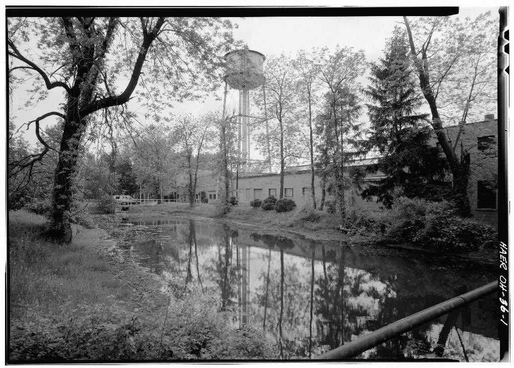
Condition of fabric: The feeder channel often becomes choked with silt and vegetation and requires frequent dredging in order to function properly. The sides of the channel are overgrown with vegetation. B. Description: The south end of the feeder channel begins at the head gate structure where the water diverted from the Cuyahoga River enters the channel. The channel then turns north and continues approximately to the downstream (north) end of Lock No. 36 where it enters the canal through a gap in the towpath embankment. A modern pedestrian bridge carries the Ohio and Erie Canal Towpath Trail over the feeder at approximately the same location as the towpath bridge depicted on the mapping. A poured concrete abutment is evidence of the former towpath bridge.
Historically there was a set of waste gates just to the west where excess water was discharged into the Cuyahoga River, but most of the gates and discharge channel are buried beneath fill and only the top of one concrete abutment wall is visible. The width of the feeder channel varies from 25' to 35' feet at the water line and 40' or more at the top of the embankments. The earthen banks on either side rise 9' to 11' above the channel and are covered with scrub vegetation. The water in the feeder is at a constant level for the structure s entire length although its depth varies, depending on the amount of accumulated silt and debris. It always has the same level as the water in the canal between Locks No. 36 and 37. C.
Mechanicals/Operation: The feeder channel is a simple earthen ditch that carries water from the Cuyahoga River to the Ohio and Erie Canal. There are no mechanical systems or machinery. Operation of the head gates is described in the documentation for that structure (HAER No. OH-59-I). D. Site Information: The Pinery Feeder is located at the head of the gorge known as the Pinery Narrows. The head gates that control the flow of water into the feeder channel are located adjacent to the dam at the south end of the channel. The surrounding terrain is fairly level and is situated about 12' above the river channel. The massive Route 82 Brecksville-Northfield High Level Bridge, built in spans the river, canal, and feeder channel.
The Ohio and Erie Canal Towpath Trail follows the route of the canal and is adjacent to the feeder channel. The canal section to the north of the feeder is watered, while the section to the south is unwatered and mostly silted in. Part III. Sources of Information A. Primary
 Block
Block