 Block
From the record
4 National Register listings published here.
Sources: the National Register database, National Park Service
63 topographic sheets cover 25 settlements here, and 4 properties are on the National Register of Historic Places.
4 National Register listings published here.
Sources: the National Register database, National Park Service
Every property in this county listed on the National Register of Historic Places, with the year it was listed and the federal nomination document.
| Photograph | Property | Type | Listed | Reference |
|---|---|---|---|---|
| Hall-Raynor Stopping Place | building | 1979 | 79000115 | |
| Moody's Camp Lodge | building | 2019 | 100004556 | |
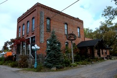 | North Wisconsin Lumber Company Office | building | 1980 | 80000403 |
| Ojibwa Courier Press Building | building | 1982 | 82000712 |
Every wildfire the federal occurrence database records inside this county: 957 of them, burning about 1,188 acres. 18 started naturally and 118 were recorded as arson. Each settlement page carries the fires within five miles of it.
| Reported cause | Fires |
|---|---|
| Debris and open burning | 238 |
| Missing data/not specified/undetermined | 205 |
| Arson/incendiarism | 118 |
| Equipment and vehicle use | 92 |
| Power generation/transmission/distribution | 83 |
| Misuse of fire by a minor | 59 |
| Recreation and ceremony | 42 |
| Other causes | 37 |
| Smoking | 25 |
| Railroad operations and maintenance | 22 |
| Fireworks | 18 |
| Natural | 18 |
The five largest, by the area the report gives. One of them was set deliberately.
| Date | Cause | Size | Reported by | Name on the report |
|---|---|---|---|---|
| 17 June 1992 | Natural | 100 acres | Wisconsin Department of Natural Resources | not named |
| 8 April 2009 | Debris and open burning | 61 acres | Wisconsin Department of Natural Resources | BETHEL FIRE |
| 29 April 2007 | Arson/incendiarism | 53 acres | Great Lakes Agency | DRY TOWN |
| 10 October 1998 | Missing data/not specified/undetermined | 47 acres | Wisconsin Department of Natural Resources | not named |
| 23 April 2009 | Recreation and ceremony | 31 acres | Wisconsin Department of Natural Resources | SIS FIRE |
| 6 April 1993 | Missing data/not specified/undetermined | 30 acres | Wisconsin Department of Natural Resources | not named |
| 20 May 2009 | Power generation/transmission/distribution | 23 acres | Chequamegon-Nicolet National Forest | MOOSE LAKE |
| 5 October 2012 | Missing data/not specified/undetermined | 23 acres | Wisconsin Department of Natural Resources | KNUTESON CREEK FIRE |
Every settlement page carries the fires within five miles of it - see the settlement index below.
The NOAA Storm Events Database holds 382 reports for this county, causing 2 deaths, 7 injuries and about $1,046,850 in recorded property damage. Each settlement page carries the reports that name it.
| Kind of event | Reports |
|---|---|
| Thunderstorm Wind | 178 |
| Hail | 171 |
| Flash Flood | 14 |
| Tornado | 8 |
| Flood | 6 |
| Lightning | 4 |
| Funnel Cloud | 1 |
The most serious of them, by death, then injury, then recorded damage. The accounts are quoted exactly as the forecast office filed them.
| When | Event | Place named | Harm | What the report says |
|---|---|---|---|---|
| June 2018 | Thunderstorm Wind | Edgewater | 1 killed, 3 hurt | Strong thunderstorm winds blew over an oak tree onto an occupied camper, killing one of the occupants and injuring 3 others. Numerous trees were blown over roadways in the area as well. |
| June 2005 | Thunderstorm Wind | Hayward | 1 killed | A 55 year-old man was killed after a thunderstorm toppled a tree onto the tent where he and his 7 year-old grandson were sleeping on Loon Point Island in the Chippewa Flowage. Rescuers found the man alive the following morning, but he died before he reached the hospital. |
| August 2021 | Lightning | Hayward Arpt | 4 hurt | Four family members visiting the Hayward area from southern Wisconsin were golfing at the Big Fish Golf Club the morning of the tenth. Storms were developing in the area at that time and one of these storms produced a lightning bolt that hit near the 5th hole's tee box where the four were standing. All four were taken to an area hospital for treatment and were alert when first responders arrived. Two were released that day while the other two remained in the hospital for an unknown length of time. All four of the victims were male and their ages were 14, 19, 38, and 72. |
| April 2023 | Flood | Moose Lake | $300,000 | Warm temperatures early in April led to rapid snowmelt of a well above normal snowpack across the region. Additionally, heavy rainfall on top of the snowpack led to additional high runoff across the county as well. Roads began to be impacted on the 12th with water overtopping low spots leading to washouts and failed culverts. Temperatures cooled during the middle of the month along with a heavy snow event the 16th into the 17th. This allowed the runoff to slow and water levels to drop. However, water levels rose again later in the month as this new snow melted as well. Numerous road closures were reported across the entire county due to failed culverts, washouts and gravel roads being washed away. Multiple communities issued disaster declarations due to the extent of washed out roads. High water continued to impact homes, driveways and farm fields through the end of the month. |
| June 1986 | Tornado (F1) | not stated | $250,000 | no account filed |
| May 2008 | Lightning | Winter | $200,000 | A house fire was caused by a lightning strike. The house was totalled. |
| July 2010 | Thunderstorm Wind | Hayward | $80,000 | A roof of a home and a garage were destroyed. Many trees were blown down in Lenroot and Hayward Townships. |
| April 2026 | Thunderstorm Wind | Hayward | $50,000 | Hayward Laundry on Dakota Ave had its roof torn off by the wind. |
| May 1994 | Thunderstorm Wind | Seeley | $50,000 | no account filed |
| July 1966 | Tornado (F1) | not stated | $25,000 | no account filed |
| July 2025 | Thunderstorm Wind | Hayward Arpt | $20,000 | Trees were snapped along Sawmill Road on the northeast side of Hayward Lake. At least one of the trees was larger than two feet in diameter per photos. One of the trees fell onto a home causing damage. |
| August 2022 | Thunderstorm Wind | Lake Chetac | $20,000 | A photo was received showing a medium-size pine tree that had been snapped and fell on a house. |
| August 2024 | Thunderstorm Wind | Stone Lake | $10,000 | Sawyer County dispatch reported multiple downed power lines on the east side of Sand Lake along County Highway F. |
| July 2011 | Thunderstorm Wind | Stone Lake | $10,000 | Thunderstorm winds toppled a large tree onto an electrical wire, almost causing a fire. Also, 1.5 miles west of Stone Lake a large oak tree fell across Highway 70 near Golden Pond Road. Also, on Lake Road trees were uprooted and went through the roof a garage and a chicken coop. A 125-year old white pine was uprooted and fell against a home, taking out a dormer. Power was lost for at least three days. Also, strong winds hit the southeast end of Stone Lake where tree loss was in the hundreds. Many boat lifts on the lake were flipped upside down. |
| August 2010 | Thunderstorm Wind | New Post | $5,000 | Numerous trees were blown down. |
| September 1993 | Thunderstorm Wind | Hayward | $5,000 | no account filed |
| May 2020 | Flash Flood | Phipps | $3,250 | Heavy rainfall the night before of 2-3 inches led to the failure of a privately-owned dam on the Mosquito Brook Flowage. When the dam gave way, a surge of water moved downstream about 2.5 miles to the Namekagon River. Culverts at both Mosquito Brook Road and Porky's Road were overwhelmed with two feet of water about 100 yards wide at both locations. This flooding cut off access to multiple homes and caused damage to roadways. Additionally, bridge damage was reported to an ATV trail and to the Birkebeiner ski trail at the crossings of Mosquito Brook. No damage was reported to any buildings or homes. Roads remained closed into the 28th before water receded. |
| July 2010 | Thunderstorm Wind | Hayward | $2,500 | Trees were blown down. |
| April 1960 | Tornado | not stated | $2,500 | no account filed |
| August 2023 | Thunderstorm Wind | Grindstone Lake | $1,000 | A large dead pine tree was down across the road. A car had hit the tree and its bumper was left in the middle of the road. |
| June 2017 | Flood | Ojibwa | $1,000 | Several sections of Wisconsin State Highway 27 flooded between Ojibwa and Couderay. |
| June 2017 | Lightning | Hayward | $1,000 | Lightning struck the top of an older white pine tree near a home. The top of the tree exploded down the center. The home was indirectly damaged due to tree shrapnel after the tree exploded. Several pieces of the tree impaled through the siding and walls into the interior of the home. |
| June 2017 | Flash Flood | Radisson | $1,000 | County Highway H closed due to water over the road. |
| June 2017 | Flash Flood | New Post | $1,000 | A culvert washed out on North County Road CC. |
| June 2017 | Flash Flood | Winter | $1,000 | Water flowed over Dam Road with a depth of 3 feet. |
| June 2017 | Flash Flood | Radisson | $1,000 | County Highway H at Beaver Brook Road closed due to flooding. |
| June 2017 | Flash Flood | New Post | $1,000 | Parts of West Flowage Road closed due to flooding. |
| May 2016 | Flood | Winter | $1,000 | A few roads were washed out due to heavy rain. |
| June 2010 | Thunderstorm Wind | Moose Lake | $1,000 | A tree estimated at 2 to 2.5 feet in diameter was blown down 1 mile southwest of Clam Lake. |
| July 2010 | Thunderstorm Wind | Radisson | $1,000 | A large tree was blown down on Highway 70/27. |
| September 2014 | Flood | Hayward | $1,000 | no account filed |
| July 2010 | Thunderstorm Wind | Stone Lake | $500 | A large tree was blown down on Bouten Road. |
| April 1994 | Hail | Exeland | $500 | no account filed |
| September 1993 | Thunderstorm Wind | Seeley | $500 | no account filed |
| July 2010 | Thunderstorm Wind | Hayward Arpt | $100 | There was minor damage to the hangars and hangar roofs at the Hayward Airport. The power was out for 3 hours according to the airport manager. |
| April 2026 | Hail | Stone Lake | - | Largest hail was half-dollar size with lots of smaller hail. |
| May 2025 | Thunderstorm Wind | Radisson | - | A six inch diameter tree was down on the eastbound lane of Highway 70. |
| May 2025 | Thunderstorm Wind | Loretta | - | A tree was down along with light outdoor furniture and tools tossed around. The wind also shredded a tarp garage. |
| May 2025 | Thunderstorm Wind | Winter | - | A tree fell onto a cabin roof and twisted and broke an antenna. |
| June 2025 | Thunderstorm Wind | Grindstone Lake | - | Large branches were broken and an aspen tree was snapped towards the top. |
| June 2025 | Thunderstorm Wind | Hayward | - | Winds damaged vendor pop up tents in downtown Hayward. About 25 to 30 percent of the tents set up experienced wind damage. |
| June 2025 | Thunderstorm Wind | New Post | - | Several trees were broken off halfway up the trunk. |
| August 2025 | Flood | Stone Lake | - | Three to six inches of water was covering both lanes of Wisconsin 70 between Main and 1st Street North in Stone Lake. |
| August 2025 | Thunderstorm Wind | Round Lake | - | Two aspen trees ten inches in diameter were uprooted. |
| August 2025 | Thunderstorm Wind | Round Lake | - | Multiple trees were down completely blocking Peninsula and Linden Road six miles east of Hayward. Roads were completely impassible. |
| June 2024 | Flash Flood | Hayward | - | All lanes of US 63 were covered with 6 to 10 inches of rushing water in Hayward. There were some localized areas where water was up to 2 feet deep. |
| June 2024 | Thunderstorm Wind | Winter | - | A photo was received showing the top two-thirds of a tree that had been snapped off. |
| July 2024 | Thunderstorm Wind | Grindstone Lake | - | A tree branch 8-12 inches in diameter was snapped off about 15-20 feet up and was down across Highway 27 near County Road K. |
| August 2024 | Thunderstorm Wind | Reserve | - | Several hardwood and softwood trees were blown down in Reserve. |
| August 2024 | Thunderstorm Wind | Edgewater | - | Several trees reported down and on a local county road on the northwest side of Lake Chetac. |
| July 2023 | Thunderstorm Wind | Moose Lake | - | Several medium to large trees were down blocking an entrance to Black Lake Campground. |
| July 2023 | Thunderstorm Wind | Moose Lake | - | A 10-inch diameter aspen tree was snapped off about 6 feet off the ground. |
| July 2023 | Thunderstorm Wind | Moose Lake | - | Numerous trees were down along Brandt Road making the road impassible. |
| July 2023 | Thunderstorm Wind | Moose Lake | - | Multiple trees around a foot in diameter or less were down along Highway 77 between County Highway OO and Forest Road 204. |
| July 2023 | Thunderstorm Wind | Seeley | - | High resolution satellite imagery depicted a swath of tree damage about a half mile in length and 120 yards in width in a west-northwest to east-southeast direction. Damage was reported in this area as well. |
| July 2023 | Thunderstorm Wind | Moose Lake | - | An 8-inch diameter 40-foot tall spruce tree was snapped at the base. |
| July 2023 | Thunderstorm Wind | Loretta | - | Several medium to large poplar trees were snapped about 10 feet off the ground. |
| July 2023 | Thunderstorm Wind | Seeley | - | A roof was partially ripped off by the winds. |
| July 2023 | Flash Flood | Seeley | - | Several medium to large washouts were reported across Boedecker Road. |
| July 2023 | Flash Flood | Seeley | - | Running water from the heavy rainfall led to gravel being washed across the pavement on Highway OO along with the ditch becoming eroded. |
The Survey's mineral resources record lists 162 workings inside this county. 9 still produce and 153 are closed or unrecorded. Each settlement page carries the workings within five miles of it.
| Commodity | Workings |
|---|---|
| Sand and Gravel, Construction | 160 |
| Copper | 1 |
| Stone, Crushed/Broken | 1 |
The least common of them first, because a county's hundredth gravel pit says nothing its first ten did not.
| Where | Site | Commodity | Status | Recorded |
|---|---|---|---|---|
| Beverly Lake Quartzite Deposit | Stone, Crushed/Broken | Occurrence | ||
| Montrose | Copper | Unknown | 1890 | |
| Anna Olson Gravel Pit | Sand and Gravel, Construction | Past Producer | ||
| Atherton Road Gravel Pit | Sand and Gravel, Construction | Past Producer | ||
| Balczewski Road Gravel Deposit #1 | Sand and Gravel, Construction | Occurrence | ||
| Balczewski Road Gravel Deposit #2 | Sand and Gravel, Construction | Occurrence | ||
| Barber Lake Sand Deposit | Sand and Gravel, Construction | Occurrence | ||
| Barber Lake Sand Pit | Sand and Gravel, Construction | Past Producer | ||
| Barker Lake Gravel Deposit | Sand and Gravel, Construction | Occurrence | ||
| Beaver Brook Road Gravel Pit | Sand and Gravel, Construction | Past Producer | ||
| Billy Boy Flowage Gravel Deposit | Sand and Gravel, Construction | Occurrence | ||
| Birch Lane Gravel Deposit | Sand and Gravel, Construction | Occurrence | ||
| Blackberry Lane Gravel Deposit | Sand and Gravel, Construction | Occurrence | ||
| Boos Lake Gravel Deposit | Sand and Gravel, Construction | Prospect | ||
| Boyd Creek Gravel Pit | Sand and Gravel, Construction | Past Producer | ||
| Brunet River Gravel Deposit #1 | Sand and Gravel, Construction | Occurrence | ||
| Brunet River Gravel Deposit #2 | Sand and Gravel, Construction | Occurrence | ||
| Brunet River Gravel Deposit #3 | Sand and Gravel, Construction | Occurrence | ||
| Brunet River Gravel Deposit #4 | Sand and Gravel, Construction | Occurrence | ||
| Brunet River Gravel Deposit #5 | Sand and Gravel, Construction | Occurrence | ||
| Brunet River Gravel Deposit #6 | Sand and Gravel, Construction | Occurrence | ||
| Brunet River Gravel Pit | Sand and Gravel, Construction | Past Producer | ||
| Brunet River Sand Deposit #1 | Sand and Gravel, Construction | Occurrence | ||
| Brunet River Sand Deposit #2 | Sand and Gravel, Construction | Occurrence | ||
| Brunet River Sand Deposit #3 | Sand and Gravel, Construction | Occurrence | ||
| Brunet River Sand Deposit #4 | Sand and Gravel, Construction | Occurrence | ||
| Brunet River Sand Pit | Sand and Gravel, Construction | Past Producer | ||
| Camp Fire Pit | Sand and Gravel, Construction | Producer | ||
| Chafer Road Gravel Deposit | Sand and Gravel, Construction | Occurrence | ||
| Chafer Road Gravel Pit | Sand and Gravel, Construction | Past Producer | ||
| Chippewa River Gravel Deposit #1 | Sand and Gravel, Construction | Occurrence | ||
| Chippewa River Gravel Deposit #2 | Sand and Gravel, Construction | Occurrence | ||
| Chippewa River Gravel Deposit #3 | Sand and Gravel, Construction | Occurrence | ||
| Chippewa River Gravel Deposit #4 | Sand and Gravel, Construction | Occurrence | ||
| Chippewa River Gravel Pit #1 | Sand and Gravel, Construction | Past Producer | ||
| Chippewa River Gravel Pit #2 | Sand and Gravel, Construction | Past Producer | ||
| Chippewa River Sand Pit | Sand and Gravel, Construction | Past Producer | ||
| Clover Road North Gravel Deposit | Sand and Gravel, Construction | Occurrence | ||
| Clover Road South Gravel Deposit | Sand and Gravel, Construction | Occurrence | ||
| Clover Road South Sand Deposit | Sand and Gravel, Construction | Occurrence | ||
| Couderay River Gravel Pit | Sand and Gravel, Construction | Past Producer | ||
| County Pit | Sand and Gravel, Construction | Unknown | ||
| Crooked Rapids Sand Deposit | Sand and Gravel, Construction | Occurrence | ||
| Dam Road Gravel Deposit | Sand and Gravel, Construction | Occurrence | ||
| Dam Road Gravel Pit | Sand and Gravel, Construction | Past Producer | ||
| Deer Creek Gravel Deposit | Sand and Gravel, Construction | Occurrence | ||
| Devils Creek Gravel Deposit | Sand and Gravel, Construction | Occurrence | ||
| Dog Patch Road Sand Deposit | Sand and Gravel, Construction | Occurrence | ||
| Dog Patch Road Sand Pit | Sand and Gravel, Construction | Past Producer | ||
| Dorscheid Road Gravel Pit | Sand and Gravel, Construction | Past Producer | ||
| Dump Road Gravel Deposit | Sand and Gravel, Construction | Occurrence | ||
| East Shore Drive Gravel Deposit | Sand and Gravel, Construction | Occurrence | ||
| East Shore Drive Gravel Pit | Sand and Gravel, Construction | Past Producer | ||
| Edwards Road Gravel Pit | Sand and Gravel, Construction | Past Producer | ||
| Endicott Road Sand Deposit #1 | Sand and Gravel, Construction | Occurrence | ||
| Endicott Road Sand Deposit #2 | Sand and Gravel, Construction | Occurrence | ||
| Exeland Gravel Pit | Sand and Gravel, Construction | Past Producer | ||
| Flambeau River Gravel Pit | Sand and Gravel, Construction | Past Producer | ||
| Flyblow Creek Gravel Pit | Sand and Gravel, Construction | Past Producer | ||
| Frank Stress Gravel Deposit | Sand and Gravel, Construction | Occurrence | ||
| Ghost Lake Gravel Deposit | Sand and Gravel, Construction | Occurrence | ||
| Goodman Lake Gravel Pit | Sand and Gravel, Construction | Prospect | ||
| Goose Lake Gravel Deposit | Sand and Gravel, Construction | Occurrence | ||
| Harz Road Gravel Deposit | Sand and Gravel, Construction | Occurrence | ||
| Hay Creek Gravel Pit | Sand and Gravel, Construction | Past Producer | ||
| Hayward Gravel Deposit #1 | Sand and Gravel, Construction | Occurrence | ||
| Hayward Gravel Deposit #2 | Sand and Gravel, Construction | Occurrence | ||
| Hayward Gravel Deposit #3 | Sand and Gravel, Construction | Occurrence | ||
| Hayward Ready Mix Concrete Pit | Sand and Gravel, Construction | Past Producer | ||
| Hayward Sand Deposit | Sand and Gravel, Construction | Occurrence | ||
| Hemlock Spur Creek Gravel Pit | Sand and Gravel, Construction | Past Producer | ||
| Hemlock Spur Creek Sand Deposit | Sand and Gravel, Construction | Occurrence | ||
| Hungry Lake Gravel Deposit | Sand and Gravel, Construction | Occurrence | ||
| Indian School Lake Gravel Deposit | Sand and Gravel, Construction | Occurrence | ||
| John Hajdasz Pit | Sand and Gravel, Construction | Unknown | ||
| Ken Miracle Pit | Sand and Gravel, Construction | Producer | ||
| Kenyon Creek Gravel Pit #1 | Sand and Gravel, Construction | Past Producer | ||
| Kenyon Creek Gravel Pit #2 | Sand and Gravel, Construction | Past Producer | ||
| King Creek Gravel Deposit #1 | Sand and Gravel, Construction | Occurrence | ||
| King Creek Gravel Deposit #2 | Sand and Gravel, Construction | Occurrence | ||
| King Creek Gravel Pit | Sand and Gravel, Construction | Past Producer | ||
| Knuteson Lake Gravel Deposit | Sand and Gravel, Construction | Occurrence | ||
| Lake Chippewa Gravel Deposit | Sand and Gravel, Construction | Occurrence | ||
| Litke Drive Gravel Deposit | Sand and Gravel, Construction | Occurrence | ||
| Little Cranberry Lake Gravel Pit #1 | Sand and Gravel, Construction | Past Producer | ||
| Little Cranberry Lake Gravel Pit #2 | Sand and Gravel, Construction | Past Producer | ||
| Little Cranberry Lake Gravel Pit #3 | Sand and Gravel, Construction | Past Producer | ||
| Little Cranberry Lake Gravel Site | Sand and Gravel, Construction | Occurrence | ||
| Loretta Gravel Deposit | Sand and Gravel, Construction | Occurrence | ||
| Loretta Lake Gravel Deposit #1 | Sand and Gravel, Construction | Occurrence | ||
| Loretta Lake Gravel Deposit #2 | Sand and Gravel, Construction | Occurrence | ||
| Loretta Lake Sand Deposit | Sand and Gravel, Construction | Occurrence | ||
| Loretta Lake Sand Pit | Sand and Gravel, Construction | Past Producer | ||
| Mcclaine Lake Gravel Deposit | Sand and Gravel, Construction | Occurrence | ||
| Mcdermott Brook Gravel Deposit | Sand and Gravel, Construction | Occurrence | ||
| Minnemac Lake Gravel Pit | Sand and Gravel, Construction | Past Producer | ||
| Mosquito Bk. Fire Ln. Gravel Pit | Sand and Gravel, Construction | Past Producer | ||
| Mosquito Brook Gravel Deposit | Sand and Gravel, Construction | Occurrence | ||
| Nail Creek Gravel Deposit #1 | Sand and Gravel, Construction | Occurrence | ||
| Nail Creek Gravel Deposit #2 | Sand and Gravel, Construction | Occurrence | ||
| Namekagon River Gravel Deposit #1 | Sand and Gravel, Construction | Occurrence | ||
| Namekagon River Gravel Deposit #2 | Sand and Gravel, Construction | Occurrence | ||
| Namekagon River Gravel Deposit #3 | Sand and Gravel, Construction | Occurrence | ||
| Namekagon River Gravel Pit #1 | Sand and Gravel, Construction | Past Producer | ||
| Nelson Lake Sand Deposit | Sand and Gravel, Construction | Occurrence | ||
| Nelson Lake Sand Pit | Sand and Gravel, Construction | Past Producer | ||
| Ojibwa Gravel Deposit #1 | Sand and Gravel, Construction | Occurrence | ||
| Ojibwa Gravel Deposit #2 | Sand and Gravel, Construction | Occurrence | ||
| Ojibwa Gravel Pit | Sand and Gravel, Construction | Past Producer | ||
| Olson Road Pit | Sand and Gravel, Construction | Producer | ||
| Oxbo Sand Pit | Sand and Gravel, Construction | Past Producer | ||
| Packwawong Lake Gravel Deposit | Sand and Gravel, Construction | Occurrence | ||
| Pfieffer Road Gravel Deposit | Sand and Gravel, Construction | Occurrence | ||
| Phipps Flowage Gravel Deposit | Sand and Gravel, Construction | Occurrence | ||
| Phipps Flowage Gravel Pit | Sand and Gravel, Construction | Past Producer | ||
| Phipps Road Gravel Deposit | Sand and Gravel, Construction | Occurrence | ||
| Pine Creek Gravel Pit | Sand and Gravel, Construction | Past Producer | ||
| Poradish Road Gravel Deposit | Sand and Gravel, Construction | Occurrence | ||
| Radisson Flowage Gravel Deposit | Sand and Gravel, Construction | Occurrence | ||
| Radisson Flowage Sand Pit | Sand and Gravel, Construction | Past Producer | ||
| Radisson Gravel Deposit | Sand and Gravel, Construction | Occurrence | ||
| Radisson Gravel Pit | Sand and Gravel, Construction | Past Producer | ||
| Radisson Sand Deposit | Sand and Gravel, Construction | Occurrence | ||
| Rock Crrek Gravel Pit | Sand and Gravel, Construction | Past Producer | ||
| Round Lake Gravel Deposit | Sand and Gravel, Construction | Occurrence | ||
| Royal Wacek Gravel Deposit | Sand and Gravel, Construction | Occurrence | ||
| Sanders Pit | Sand and Gravel, Construction | Producer | ||
| Sawyer County Peninsula Pit | Sand and Gravel, Construction | Producer | ||
| Seeley Firelane Gravel Deposit | Sand and Gravel, Construction | Occurrence | ||
| Seeley Firelane Gravel Pit | Sand and Gravel, Construction | Past Producer | ||
| Seeley Gravel Deposit #1 | Sand and Gravel, Construction | Occurrence | ||
| Seeley Gravel Deposit #2 | Sand and Gravel, Construction | Occurrence | ||
| Senesac Road Gravel Deposit #1 | Sand and Gravel, Construction | Occurrence | ||
| Senesac Road Gravel Deposit #2 | Sand and Gravel, Construction | Occurrence | ||
| Shop Pit | Sand and Gravel, Construction | Producer | ||
| Ski Hill Road Gravel Deposit | Sand and Gravel, Construction | Occurrence | ||
| Smith Lake Creek Gravel Deposit #1 | Sand and Gravel, Construction | Occurrence | ||
| Smith Lake Creek Gravel Deposit #2 | Sand and Gravel, Construction | Occurrence | ||
| Smith Lake Gravel Deposit | Sand and Gravel, Construction | Occurrence | ||
| Smith Lake Gravel Pit | Sand and Gravel, Construction | Past Producer | ||
| Spring Lake Creek Sand Deposit #1 | Sand and Gravel, Construction | Occurrence | ||
| Spring Lake Creek Sand Deposit #2 | Sand and Gravel, Construction | Occurrence | ||
| Stoney Hill Road Gravel Deposit | Sand and Gravel, Construction | Occurrence | ||
| Stress Pit | Sand and Gravel, Construction | Producer | ||
| Summit Lake Gravel Deposit | Sand and Gravel, Construction | Occurrence | ||
| Summit Lake Road Gravel Pit | Sand and Gravel, Construction | Past Producer | ||
| Thompson Pit | Sand and Gravel, Construction | Producer | ||
| Thornapple River Gravel Pit | Sand and Gravel, Construction | Producer | ||
| Tiger Cat Flowage Gravel Pit | Sand and Gravel, Construction | Past Producer | ||
| Town Line Road Gravel Pit | Sand and Gravel, Construction | Past Producer | ||
| Turk Spring Gravel Deposit | Sand and Gravel, Construction | Occurrence | ||
| Twin Lake Road Gravel Pit | Sand and Gravel, Construction | Past Producer | ||
| Venison Creek Road Gravel Pit | Sand and Gravel, Construction | Past Producer | ||
| Venison Spring Gravel Pit | Sand and Gravel, Construction | Past Producer | ||
| Windigo Lake Gravel Deposit | Sand and Gravel, Construction | Occurrence | ||
| Windigo Lake Gravel Pit | Sand and Gravel, Construction | Past Producer | ||
| Winter Dam Gravel Pit | Sand and Gravel, Construction | Past Producer | ||
| Winter Gravel Deposit #1 | Sand and Gravel, Construction | Occurrence | ||
| Winter Gravel Deposit #2 | Sand and Gravel, Construction | Occurrence | ||
| Winter Gravel Pit #1 | Sand and Gravel, Construction | Past Producer | ||
| Winter Gravel Pit #2 | Sand and Gravel, Construction | Past Producer | ||
| Zesiger Road Gravel Deposit | Sand and Gravel, Construction | Occurrence |
Named settlements recorded in the Geographic Names Information System, each with the topographic sheets covering it. Villages, hamlets and abandoned places alike. Each is shown with the nearest named watercourse or landform and the survey quadrangle it falls on.
Edgewater town · 54817 · On Thirty-three Creek · Edgewater quadrangle
8 sheets, 1945 to 1980