 Block
From the record
One of 50 National Register listings published here for Walworth County · listed in 1974 · category: Building · built in 1844.
Sources: the case file at the National Archives · the National Register database, National Park Service
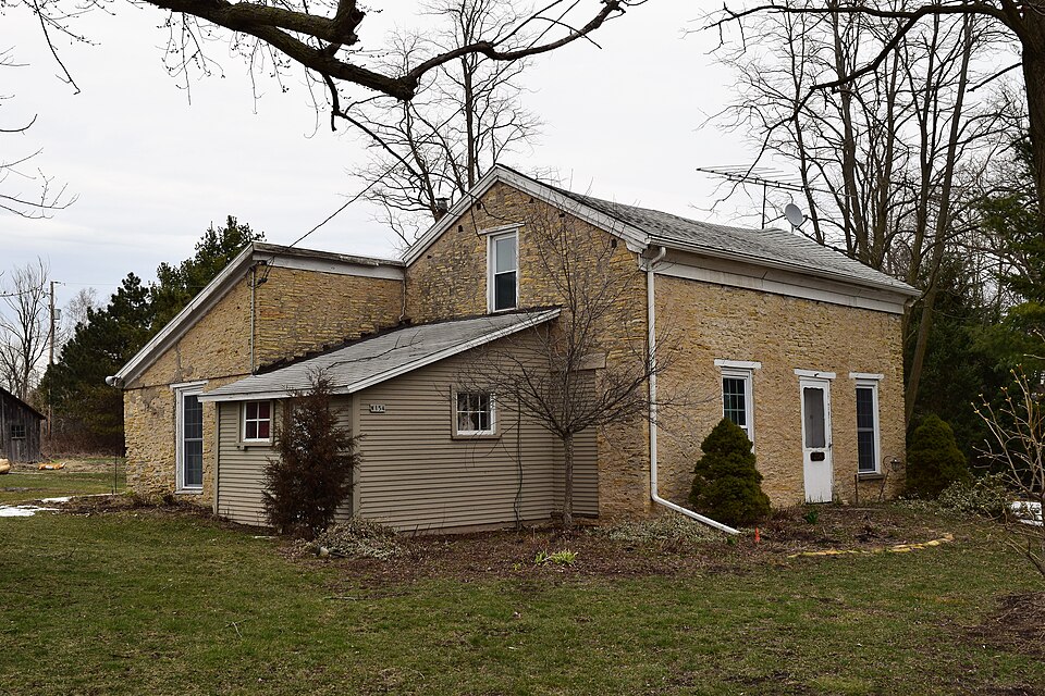
Built in 1844. Listed on the National Register of Historic Places in 1974.
One of 50 National Register listings published here for Walworth County · listed in 1974 · category: Building · built in 1844.
Sources: the case file at the National Archives · the National Register database, National Park Service
The chapter on Spring Prairie Town in History of Walworth County, Wisconsin .., published 1912 names Burlington. This is what it says, exactly as the scans read.
At the division of the county into five towns, January 2, 1838, the two townships, each numbered 3 north, lying in ranges 17 and 18 east, were included in the town of Spring Prairie, and were so joined until March 21, 1843. when the westernmost town was set off as Lafayette. The name was suggested to Mrs. Abigail A. ( Whitmore) Heminway by the natural features of the southern half of the town - the springs being in sections 19 and 20 and discharging themselves into Spring brook, a branch of Sugar creek. Rochester and Burlington lie eastward.
Passage source: History of Walworth County, Wisconsin .., published 1912.
Vienna, on Sugar creek, was at first called Martinsburg, from the related Martin families who settled near that point. Judge Martin's saw mill gave place to a good grist mill, which in 1853 became the property of Edwan! /aim, who improved it greatly and for several years made his flour locally famous. His sons, Cornelius and Victor, continued the business for a few years. The mill was disused and then burned. Winslow Page Storms built the Vienna House in 1848 and used it for many years as a tavern and a store, and as a postoffice. It long ago became a private dwelling; for men go to Spring Prairie to buy, to Burlington for prescriptions, and each to his own door or gate for mail. A little burial ground lies a bit more than a half mile southwest of the village, on the way to Spring Prairie and to Burlington. Little mure than tradition now remains of Vienna and its past and prospective greatness.
Passage source: History of Walworth County, Wisconsin .., published 1912.
Machine-read from a century-old scan, so expect the errors a machine makes: misspelled names, dropped words, stray characters.
Read the whole chapter on Spring Prairie Town - 5,113 words on its settlement, mills, schools and churches.
Regional context, not property-specific evidence. The federal wildfire occurrence database lists 27 fires within 5 miles of James Jesse Strang House between 2018 and 2020, burning about 42 acres in total. 2 started naturally. 2 were recorded as arson. Distance is straight-line from the map coordinates, so a fire counted here may appear on a neighbouring settlement's page as well.
| Reported cause | Fires |
|---|---|
| Missing data/not specified/undetermined | 13 |
| Debris and open burning | 9 |
| Arson/incendiarism | 2 |
| Natural | 2 |
| Recreation and ceremony | 1 |
The most recent of them, most recent first, with the day each was reported and the service that recorded it.
| Date | Cause | Size | Reported by | Name on the report |
|---|---|---|---|---|
| 5 September 2020 | Recreation and ceremony | under an acre | Wisconsin Department of Natural Resources | 164 |
| 26 August 2018 | Natural | 1.0 acres | Wisconsin Department of Natural Resources | 217 |
| 1 August 2018 | Debris and open burning | 1.0 acres | Wisconsin Department of Natural Resources | 191 |
| 9 June 2020 | Missing data/not specified/undetermined | 1.0 acres | Wisconsin Department of Natural Resources | 717 |
| 1 June 2018 | Debris and open burning | 1.0 acres | Wisconsin Department of Natural Resources | 517 |
| 4 May 2018 | Missing data/not specified/undetermined | under an acre | Wisconsin Department of Natural Resources | 97 |
| 2 May 2018 | Natural | under an acre | Wisconsin Department of Natural Resources | 132 |
| 7 April 2018 | Debris and open burning | 20 acres | Wisconsin Department of Natural Resources | 75 |
Regional context, not property-specific evidence. The federal mineral resources record lists 10 workings within 5 miles of James Jesse Strang House: 5 producers, 5 past producers. 5 still produce. What was taken out: Sand and Gravel, Construction, Stone, Crushed/Broken. Distance is straight-line from the map coordinates, so a quarry counted here may appear on a neighbouring settlement's page as well.
| Where | Site | Commodity | Status | Recorded |
|---|---|---|---|---|
| Limestone Quarry #3 | Stone, Crushed/Broken | Producer | ||
| Pit Number 3 | Stone, Crushed/Broken, Sand and Gravel, Construction | Past Producer | ||
| Burlington Pit | Sand and Gravel, Construction | Past Producer | ||
| Burlington Pit Yard 12 | Sand and Gravel, Construction | Producer | ||
| Dons Pit | Sand and Gravel, Construction | Producer | ||
| Ed Prott Pit | Sand and Gravel, Construction | Past Producer | ||
| J W Peters and Sons Inc Pit No 1 | Sand and Gravel, Construction | Producer | ||
| Payne and Dolan Pit | Sand and Gravel, Construction | Past Producer | ||
| Racine County Hwy Dept Frost Pit | Sand and Gravel, Construction | Producer | ||
| Rochester Pit | Sand and Gravel, Construction | Past Producer |
No historic map-sheet match is published for this property yet. That does not mean no map exists. This record needs a coordinate-quality review before it can be joined to a sheet boundary. Browse the county's mapped places while that work is pending.
Other National Register properties close enough to walk or drive between, ordered by distance from this one. Both positions come from the same geocoding pass that matched these properties to their map sheets.
| Photograph | Property | Distance | Listed |
|---|---|---|---|
 | John and Margaret Bell House | 1.5 miles | 1994 |
 | Carl and Clara Bucholtz Farmstead | 6.0 miles | 2018 |
 | Horace Loomis House | 7.1 miles | 1974 |
| National Archives record | The nomination case file for reference 74000135 in Record Group 79. |
| Walworth County | All 50 listed properties in this county. |