BlockBefore
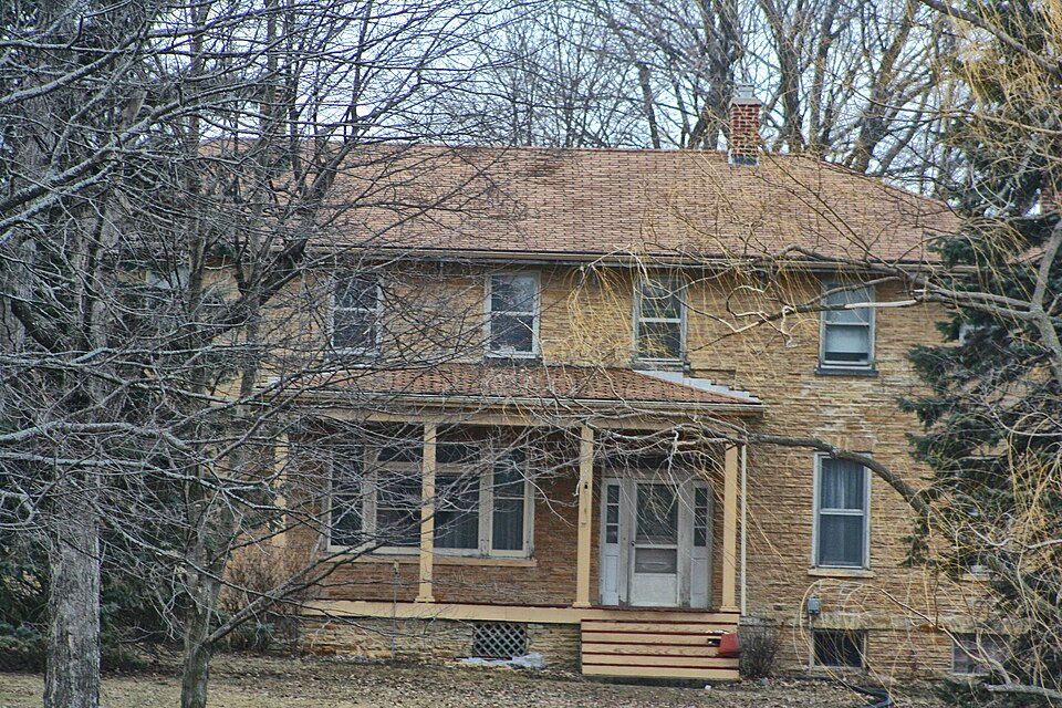
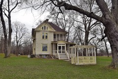
Photograph of John and Margaret Bell House
Photograph by Tgkrause, CC BY-SA 3.0. Via Wikimedia Commons.

John and Margaret Bell House

Built in 1850 (Greek Revival architecture). Listed on the National Register of Historic Places in 1994.

From the record

“The John and Margaret Bell House is located in Spring Prairie, Wisconsin. The two-story stone house, built of local sandstone c. 1850 sits on a 3.8 acre parcel.”

Wikipedia article John and Margaret Bell House, CC BY-SA 4.0.

One of 50 National Register listings published here for Walworth County · listed in 1994 · category: Building · built in 1850, Greek Revival architecture.

Sources: the Wikipedia article · the case file at the National Archives · the National Register database, National Park Service
The listing

  • Listed as. Bell, John and Margaret, House - the National Register files a house under its owner's surname.
  • Address. 554 Spring Prairie Rd., Spring Prairie, 53105
  • When was it listed? September 1994
  • Category. building
  • Town. Spring Prairie town
  • When was it built? 1850
  • Architectural style. Greek Revival architecture, Italianate architecture
  • National Register reference number. 94001154 - the number the National Park Service assigned this property when it was listed, and the key its nomination file is catalogued under at the National Archives.

The ground it stands on

5,113 words

The chapter on Spring Prairie Town in History of Walworth County, Wisconsin .., published 1912 names Spring Prairie. This is what it says, exactly as the scans read.

The highway from Lake Geneva to East Troy, by way of the village of Spring Prairie, is crossed by the railway 2.8 miles west of Lyons, on the south side of section 7. This road was for many years, before and after a station was made there, an important mail route, and hence a convenient point for retail trade, grain and wool buying, and lumber-selling. In the mid seventies considerable shipments of dressed poultry were made, largely to Boston buyers. Changes in the industries of the county, with consequent effects on the business of villages, have checked the growth of Springfield, though it is not yet a wholly deserted village. A fire in 1910 destroyed the station building. After more than a year of delay it was rebuilt, better than before, and this with a long line of wide cement platform shows that Springfield is yet of some importance to the railway company Amid the discontinuances of small postoffices the office at this place remains as one of the fourth class, indispensable for local and northern service. That part of the road between the station and Lake Geneva, about three and one-half miles, is a stage and mail route on which three trips are made daily, from the lake. For many years Ansel Knowles (died August 19, 1875), of Lake Geneva, made these trips through sunshine, rain and snow, and became well and favorably known to thousands of passengers.

Passage source: History of Walworth County, Wisconsin .., published 1912.

At the division of the county into five towns, January 2, 1838, the two townships, each numbered 3 north, lying in ranges 17 and 18 east, were included in the town of Spring Prairie, and were so joined until March 21, 1843. when the westernmost town was set off as Lafayette. The name was suggested to Mrs. Abigail A. ( Whitmore) Heminway by the natural features of the southern half of the town - the springs being in sections 19 and 20 and discharging themselves into Spring brook, a branch of Sugar creek. Rochester and Burlington lie eastward.

Passage source: History of Walworth County, Wisconsin .., published 1912.

Machine-read from a century-old scan, so expect the errors a machine makes: misspelled names, dropped words, stray characters.

Read the whole chapter on Spring Prairie Town - 5,113 words on its settlement, mills, schools and churches.

Fires near this property

18 since 2018

Regional context, not property-specific evidence. The federal wildfire occurrence database lists 18 fires within 5 miles of John and Margaret Bell House between 2018 and 2020, burning about 33 acres in total. 2 started naturally. 2 were recorded as arson. Distance is straight-line from the map coordinates, so a fire counted here may appear on a neighbouring settlement's page as well.

Reported cause Fires
Debris and open burning7
Missing data/not specified/undetermined7
Arson/incendiarism2
Natural2

The most recent of them, most recent first, with the day each was reported and the service that recorded it.

DateCause SizeReported by Name on the report
26 August 2018Natural1.0 acresWisconsin Department of Natural Resources217
1 August 2018Debris and open burning1.0 acresWisconsin Department of Natural Resources191
9 June 2020Missing data/not specified/undetermined1.0 acresWisconsin Department of Natural Resources717
1 June 2018Debris and open burning1.0 acresWisconsin Department of Natural Resources517
4 May 2018Missing data/not specified/undeterminedunder an acreWisconsin Department of Natural Resources97
2 May 2018Naturalunder an acreWisconsin Department of Natural Resources132
7 April 2018Debris and open burning20 acresWisconsin Department of Natural Resources75
7 April 2018Missing data/not specified/undeterminedunder an acreWisconsin Department of Natural Resources67

Every fire recorded in Walworth County

Mines and quarries near this property

5 within 5 miles

Regional context, not property-specific evidence. The federal mineral resources record lists 5 workings within 5 miles of John and Margaret Bell House: 4 producers, 1 past producer. 4 still produce. What was taken out: Sand and Gravel, Construction, Stone, Crushed/Broken. Distance is straight-line from the map coordinates, so a quarry counted here may appear on a neighbouring settlement's page as well.

Where SiteCommodity StatusRecorded
Limestone Quarry #3Stone, Crushed/BrokenProducer
Dons PitSand and Gravel, ConstructionProducer
J W Peters and Sons Inc Pit No 1Sand and Gravel, ConstructionProducer
Payne and Dolan PitSand and Gravel, ConstructionPast Producer
Racine County Hwy Dept Frost PitSand and Gravel, ConstructionProducer

Every working recorded in Walworth County

Storms near this property

8 since 1995

Regional context, not property-specific evidence. The National Weather Service names Spring Prairie, the town this property stands in, in 8 storm reports between 1995 and 2025: 5 thunderstorm wind, 3 hail. No death or injury is recorded in these reports. Each account below is quoted exactly as the forecast office filed it, from the NOAA Storm Events Database, and each date opens the federal record of that event.

WhenEvent Place namedHarm What the report says
November 2020Thunderstorm WindSpring Prairie$3,000Multiple large trees snapped in Spring Prairie.
July 2005Thunderstorm WindSpring Prairie$3,000no account filed
July 2007HailSpring Prairie-Thunderstorm wind gusts to about 39 knots (45 mph) also noted.
May 2025HailSpring Prairie-no account filed
August 2002HailSpring Prairie-no account filed
August 2001Thunderstorm WindSpring Prairie-no account filed
July 1995Thunderstorm WindSpring Prairie-no account filed
August 1995Thunderstorm WindSpring Prairie-no account filed

Every storm recorded in Walworth County

Map coverage status

No historic map-sheet match is published for this property yet. That does not mean no map exists. This record needs a coordinate-quality review before it can be joined to a sheet boundary. Browse the county's mapped places while that work is pending.

Listed places nearby

6 within 8 miles

Other National Register properties close enough to walk or drive between, ordered by distance from this one. Both positions come from the same geocoding pass that matched these properties to their map sheets.

Photograph PropertyDistance Listed
James Jesse Strang House1.5 miles1974
Carl and Clara Bucholtz Farmstead4.9 miles2018
Horace Loomis House5.6 miles1974
Buena Vista House7.1 miles1978
Smith and Meadows Store Buildings7.2 miles1993
Sheboygan Light, Power and Railway Company Car #267.4 miles2006

Sources for this property

National Archives recordThe nomination case file for reference 94001154 in Record Group 79.
Wikipedia articleCommunity-written account of this property, licensed CC BY-SA.
Walworth CountyAll 50 listed properties in this county.

Provenance

  • Listing record. National Park Service National Register of Historic Places, listed-properties dataset, current to 2026-05-22.
  • Map join. Address geocoded through the United States Census geocoder, then tested against the published boundary of every sheet in the USGS Historical Topographic Map Collection.
  • How this page is made. Listing fields come from federal records; map-sheet coverage is a labelled coordinate-to-boundary calculation, not a source-field claim.
  • Wildfire. Short, Karen C. 2022. Spatial wildfire occurrence data for the United States, 1992-2020 [FPA_FOD_20221014]. 6th Edition. Fort Collins, CO: Forest Service Research Data Archive. https://doi.org/10.2737/RDS-2013-0009.6 Collected with United States Government funding and usable without additional permissions or fees.
  • Mines and quarries. USGS Mineral Resources Data System (MRDS) https://mrdata.usgs.gov/mrds/ A work of the United States government, no copyright under 17 U.S.C. 105.
  • Storms. NOAA National Centers for Environmental Information, Storm Events Database https://www.ncei.noaa.gov/stormevents/ A work of the United States government, no copyright under 17 U.S.C. 105. Narratives are quoted verbatim from the National Weather Service report and are not edited or summarised.