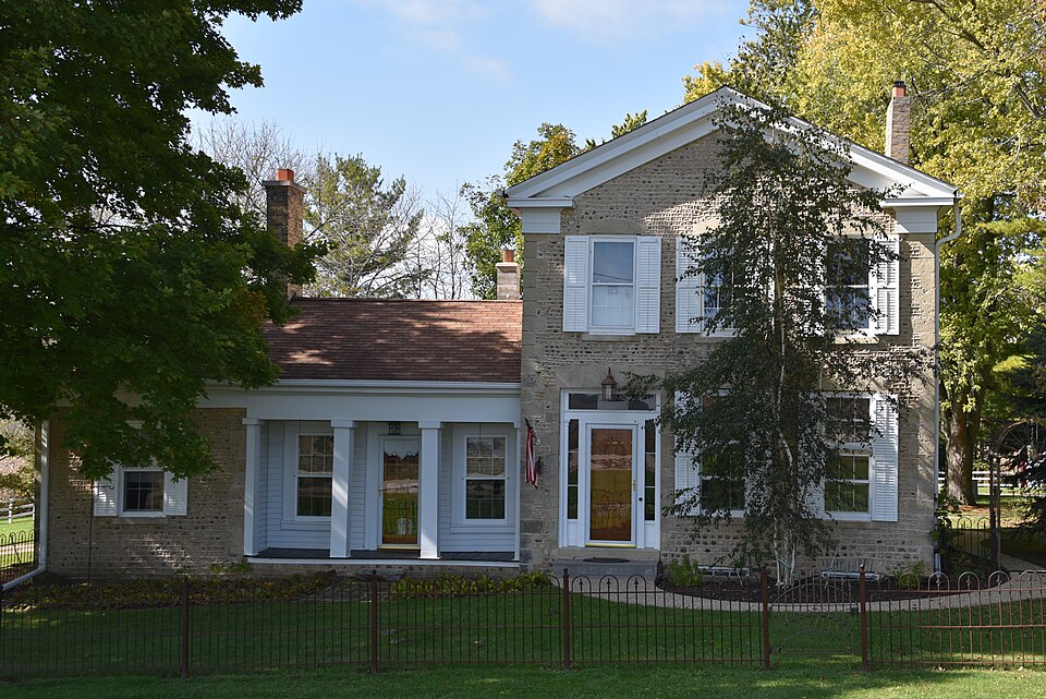
Built in 1851 (Greek Revival architecture). Listed on the National Register of Historic Places in 1974.
From the record
One of 50 National Register listings published here for Walworth County · listed in 1974 · category: Building · built in 1851, Greek Revival architecture.
National Register reference number.74000357- the number the National Park Service assigned this property when it was listed, and the key its nomination file is catalogued under at the National Archives.
The ground it stands on
5,113 words
The chapter on Spring Prairie Town in History of Walworth County, Wisconsin .., published 1912 names East Troy. This is what it says, exactly as the scans read.
The highway from Lake Geneva to East Troy, by way of the village of Spring Prairie, is crossed by the railway 2.8 miles west of Lyons, on the south side of section 7. This road was for many years, before and after a station was made there, an important mail route, and hence a convenient point for retail trade, grain and wool buying, and lumber-selling. In the mid seventies considerable shipments of dressed poultry were made, largely to Boston buyers. Changes in the industries of the county, with consequent effects on the business of villages, have checked the growth of Springfield, though it is not yet a wholly deserted village. A fire in 1910 destroyed the station building. After more than a year of delay it was rebuilt, better than before, and this with a long line of wide cement platform shows that Springfield is yet of some importance to the railway company Amid the discontinuances of small postoffices the office at this place remains as one of the fourth class, indispensable for local and northern service. That part of the road between the station and Lake Geneva, about three and one-half miles, is a stage and mail route on which three trips are made daily, from the lake. For many years Ansel Knowles (died August 19, 1875), of Lake Geneva, made these trips through sunshine, rain and snow, and became well and favorably known to thousands of passengers.
First settlers found about three-fourths of the township more or less wooded - forests and openings. Spring prairie, in the southwestern part, and Gardners prairie, in the southeastern quarter, have each from fifteen hundred to two thousand acres of natural garden. A smaller meadow, a half section or more in area, lies near Honey Creek, in the northeast. Sugar creek enters at section 7, crosses a little south of east and meets Honey creek near the county line at the southeast corner of section 13. The latter comes out of East Troy and runs nearly due southward through sections 1. 12 and 13. Spring brook, entering at section 19, meets Sugar creek near the town center. Marsh creek begins in section 10. and by way of section 1 1 reaches Honey creek in section 12. White river winds a few miles in section 36 and escapes into Racine county by way of the southeast corner of section 25. The southern sections are drained by small southward-flowing branches of the White. These larger streams were in earlier days made useful for driving saw-mills and grist-mills. For a few miles along Sugar creek, on each side, the ground rises to parallel ridges which give the highway from Spring Prairie village to East Troy almost a down-eastern ruggedness of profile Limestone crops out in some of the valleys, more noticeably in sections 16 and 36. though quarries have been worked but superficially and for local use. This is presumptively of the Niagara formation. Elevations above sea-level, at ten points of observation, vary between ju<< and 979 feet - the lowest in sections 36. the highest in section 5. The average height in sections 7 and 8 is 918 feet.
Regional context, not property-specific
evidence. The
federal wildfire occurrence database
lists 11 fires within 5 miles of Horace Loomis House
between 2018 and 2020, burning about 67 acres in total. None started naturally. 1 was recorded as arson.
Distance is straight-line from the map coordinates, so a fire counted
here may appear on a neighbouring settlement's page as well.
Reported cause
Fires
Missing data/not specified/undetermined
5
Debris and open burning
5
Arson/incendiarism
1
The most recent of
them, most recent first, with the day each was reported and the service
that recorded it.
Regional context, not property-specific
evidence. The federal mineral resources record lists
4 workings within 5 miles of Horace Loomis House: 2 past producers, 1 unknown, 1 occurrence.
None of them still produces. What was taken out: Sand and Gravel, Construction. Distance is straight-line from the
map coordinates, so a quarry counted here may appear on a neighbouring
settlement's page as well.
Regional context, not property-specific
evidence. The National Weather Service names
East Troy, the town this property stands in, in 39 storm reports between 1995 and 2026: 22 thunderstorm wind, 13 hail, 2 lightning, 1 funnel cloud.
The reports record 10 injuries. Each account below is quoted exactly as the forecast office
filed it, from the NOAA Storm Events Database, and each date
opens the federal record of that event.
Powerful, hurricane-force thunderstorms winds knocked down many trees, power-lines, and an old silo. Additionally, part of a roof of a barn was ripped off, a concrete wall of a machine shed was blown in, and 2 semi tractor-trailers were blown over on Interstate-43. Peak wind gusts were estimated at 78 knots (90 mph), but this number could be 9 knots (10 mph) too low or too high.
The Walworth County 911 Call Center received reports of trees and power lines downed by thunderstorm wind gusts estimated at 60 mph (52 knots) in East Troy.
Tree damage from near Beulah Station (east of city of East Troy) to Honey Creek was noted by a trained spotter. Based on the size of the limbs and trees blown down they estimated winds in excess of 52 knots (60 mph).
No historic map-sheet match is published
for this property yet. That does not mean no map exists. This record needs
a coordinate-quality review before it can be joined to a sheet boundary.
Browse the county's mapped places while that work is
pending.
Listed places nearby
6 within 8 miles
Other National Register properties close
enough to walk or drive between, ordered by distance from this one. Both
positions come from the same geocoding pass that matched these properties
to their map sheets.
Listing record. National Park Service National Register of Historic Places, listed-properties dataset, current to 2026-05-22.
Map join. Address geocoded through the United States Census geocoder, then tested against the published boundary of every sheet in the USGS Historical Topographic Map Collection.
How this page is made. Listing fields come from federal records; map-sheet coverage is a labelled coordinate-to-boundary calculation, not a source-field claim.
Wildfire. Short, Karen C. 2022. Spatial wildfire occurrence data for the United States, 1992-2020 [FPA_FOD_20221014]. 6th Edition. Fort Collins, CO: Forest Service Research Data Archive. https://doi.org/10.2737/RDS-2013-0009.6 Collected with United States Government funding and usable without additional permissions or fees.
Mines and quarries. USGS Mineral Resources Data System (MRDS) https://mrdata.usgs.gov/mrds/ A work of the United States government, no copyright under 17 U.S.C. 105.
Storms. NOAA National Centers for Environmental Information, Storm Events Database https://www.ncei.noaa.gov/stormevents/ A work of the United States government, no copyright under 17 U.S.C. 105. Narratives are quoted verbatim from the National Weather Service report and are not edited or summarised.
 Block