 Block
From the record
One of 36 National Register listings published here for Dodge County · listed in 1996 · category: Building.
Sources: the case file at the National Archives · the National Register database, National Park Service
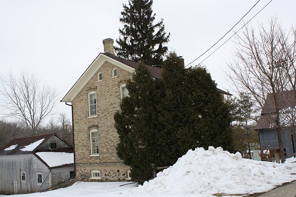
Listed on the National Register of Historic Places in 1996.
One of 36 National Register listings published here for Dodge County · listed in 1996 · category: Building.
Sources: the case file at the National Archives · the National Register database, National Park Service
The chapter on Hustisford Town in The History of Dodge County, Wisconsin, Containing ... Its Early Settlement, Growth ... an Extensive and Minute Sketch of Its Cities ... War Record, Biographical Sketches, published 1880 names Hustisford. This is what it says, exactly as the scans read.
As illustrating how near a place can come to being made famous, and yet see its hopes disappear, it is said that the village of Hustisford came within one vote of being selected as the State capital by the Territorial Legislature. The Iowa members of that body, wishing and expecting their Territory to be separated from Wisconsin, voted as their pecuniary interest dictated.
Passage source: The History of Dodge County, Wisconsin, Containing ... Its Early Settlement, Growth ... an Extensive and Minute Sketch of Its Cities ... War Record, Biographical Sketches, published 1880.
In the village limits there is but one hotel, that of the Hustisford House, by Louis Prenzlow, which has a central location and is well patronized. The Wisconsin House was burned to the ground during the fall of 1879, and has not been rebuilt.
Passage source: The History of Dodge County, Wisconsin, Containing ... Its Early Settlement, Growth ... an Extensive and Minute Sketch of Its Cities ... War Record, Biographical Sketches, published 1880.
Machine-read from a century-old scan, so expect the errors a machine makes: misspelled names, dropped words, stray characters.
Read the whole chapter on Hustisford Town - 10,282 words on its settlement, mills, schools and churches.
Regional context, not property-specific evidence. The federal wildfire occurrence database lists 3 fires within 5 miles of Ferdinand Schulze House between 1994 and 1996, burning about 6 acres in total. None started naturally. 2 were recorded as arson. Distance is straight-line from the map coordinates, so a fire counted here may appear on a neighbouring settlement's page as well.
| Reported cause | Fires |
|---|---|
| Arson/incendiarism | 2 |
| Debris and open burning | 1 |
The most recent of them, most recent first, with the day each was reported and the service that recorded it.
| Date | Cause | Size | Reported by | Name on the report |
|---|---|---|---|---|
| 20 May 1994 | Arson/incendiarism | 2.0 acres | Wisconsin Department of Natural Resources | not named |
| 1 May 1996 | Arson/incendiarism | 1.2 acres | Wisconsin Department of Natural Resources | not named |
| 23 April 1994 | Debris and open burning | 2.5 acres | Wisconsin Department of Natural Resources | not named |
Regional context, not property-specific evidence. The federal mineral resources record lists 5 workings within 5 miles of Ferdinand Schulze House: 5 past producers. None of them still produces. What was taken out: Sand and Gravel, Construction. Distance is straight-line from the map coordinates, so a quarry counted here may appear on a neighbouring settlement's page as well.
| Where | Site | Commodity | Status | Recorded |
|---|---|---|---|---|
| Allen Rudolph Pit | Sand and Gravel, Construction | Past Producer | ||
| Bartosch Pit | Sand and Gravel, Construction | Past Producer | ||
| Bohnert Pit | Sand and Gravel, Construction | Past Producer | ||
| Kranich Pit | Sand and Gravel, Construction | Past Producer | ||
| Roll Pit | Sand and Gravel, Construction | Past Producer |
Regional context, not property-specific evidence. The National Weather Service names Hustisford, the town this property stands in, in 15 storm reports between 1999 and 2025: 10 thunderstorm wind, 2 hail, 1 lightning, 1 flood. No death or injury is recorded in these reports. Each account below is quoted exactly as the forecast office filed it, from the NOAA Storm Events Database, and each date opens the federal record of that event.
| When | Event | Place named | Harm | What the report says |
|---|---|---|---|---|
| November 2013 | Thunderstorm Wind | Hustisford | $75,600 | A squall line produced an estimated 100 mph downburst just east of Hustisford.|An equipment building had its roof removed with some walls collapsed. A calf shed was destroyed with large items within the shed displaced. The town hall had minor damage to its roof and the flag pole was bent. A wooden power pole was snapped and some shingles were removed from a home. About a dozen trees were downed with some being snapped and some uprooted. One tree fell on a home and some corn was damaged. |
| June 2024 | Flood | Hustisford | $10,000 | Flooding of several basements and yards on the west side of Iron Ridge when a culvert became plugged. The electricity was shut off until the water receded. The flooding of a creek eroded the shoulder of County Highway AY near Madison Road, just east of Iron Ridge. A business dock was flooded in Horicon. |
| June 2016 | Thunderstorm Wind | Hustisford | $10,000 | Numerous large trees and branches down. |
| May 2011 | Thunderstorm Wind | Hustisford | $10,000 | Numerous trees and power lines were reported blown down by damaging thunderstorm wind gusts in the Hustisford area. A tree fell on a home damaging the roof. A tree fell on an occupied car, and the driver injured his shoulder (indirectly-related) exiting the car. Total damage in the area amounted to $10,000. |
| April 2023 | Thunderstorm Wind | Hustisford | $5,000 | Straight-line winds from a thunderstorm outflow boundary uprooted a few trees and blew a shed apart. |
| June 1999 | Thunderstorm Wind | Hustisford | $5,000 | no account filed |
| July 2015 | Thunderstorm Wind | Hustisford | $4,000 | A large tree fell on a home. |
| July 2023 | Thunderstorm Wind | Hustisford | $3,000 | A tree branch around 4-6 inches in diameter fell onto a residential structure. |
| July 2025 | Tornado (EF0) | Hustisford | $2,000 | Tornado developed south of Hustisford near the intersection of Hillcrest Road and County Road E where a corn field had a convergent path going north-northeast through mainly farmland. The tornado hit some trees south of Highway 60 and east of County Road E before tracking north and going through the intersection of Juneau Street and Oakwood Boulevard. The tornado appears to have ended over Sinissippi Lake. |
| June 2020 | Thunderstorm Wind | Hustisford | $2,000 | Tree and power line damage with a tree on fire. |
| July 2011 | Lightning | Hustisford | $2,000 | Newspapers reported a lightning strike that caused a minor fire at a home on State Highway 60, just west of Hustisford. The fire filled the basement with smoke. |
| May 2011 | Thunderstorm Wind | Hustisford | $500 | A second round of severe thunderstorms affected Hustisford with damaging winds. This round downed trees that damaged a fence and did $500 worth of damage to a house. |
| June 2006 | Thunderstorm Wind | Hustisford | - | Trees down. |
| May 2014 | Hail | Hustisford | - | no account filed |
| March 2007 | Hail | Hustisford | - | no account filed |
No historic map-sheet match is published for this property yet. That does not mean no map exists. This record needs a coordinate-quality review before it can be joined to a sheet boundary. Browse the county's mapped places while that work is pending.
Other National Register properties close enough to walk or drive between, ordered by distance from this one. Both positions come from the same geocoding pass that matched these properties to their map sheets.
| Photograph | Property | Distance | Listed |
|---|---|---|---|
 | John Hustis House | 0.3 miles | 1983 |
 | Neosho Village Hall | 4.7 miles | 2018 |
| Schoenicke Barn | 6.5 miles | 1979 | |
| Van Brunt Memorial School | 7.2 miles | 2020 | |
 | Horicon State Bank | 7.4 miles | 2018 |
 | Daniel C. Van Brunt House | 7.5 miles | 1981 |
| National Archives record | The nomination case file for reference 95001503 in Record Group 79. |
| Dodge County | All 36 listed properties in this county. |