 Block
From the record
19 National Register listings published here.
Sources: the National Register database, National Park Service
100 topographic sheets cover 44 settlements here, and 19 properties are on the National Register of Historic Places.
19 National Register listings published here.
Sources: the National Register database, National Park Service
Every property in this county listed on the National Register of Historic Places, with the year it was listed and the federal nomination document.
| Photograph | Property | Type | Listed | Reference |
|---|---|---|---|---|
 | Fuller, R. Buckminster, and Anne Hewlett Dome Home | building | 2006 | 06000012 |
 | Giant City State Park Lodge and Cabins | building | 1985 | 85002403 |
 | Giant City Stone Fort Site | site | 2002 | 02000848 |
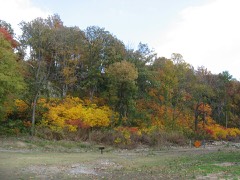 | Grand Tower Mining, Manufacturing and Transportation Company Site | site | 1979 | 79000839 |
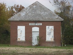 | Grange Hall | building | 1990 | 90000722 |
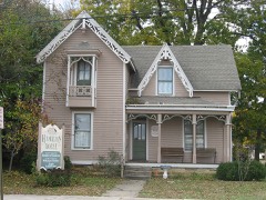 | Robert W. Hamilton House | building | 1982 | 82002540 |
 | Cornelius Hennessy Building | building | 2000 | 00001331 |
 | William H. Hull House | building | 2006 | 05001602 |
 | Illinois Central Railroad Passenger Depot | building | 2002 | 02000457 |
 | Jackson County Courthouse | building | 2015 | 15000931 |
 | Liberty Theater | building | 2012 | 12000322 |
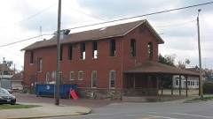 | Mobile and Ohio Railroad Depot | building | 1984 | 84000317 |
| Murphysboro Downtown Historic District | district | 2022 | 100008487 | |
 | Murphysboro Elks Lodge | building | 2005 | 05001255 |
| Murphysboro Masonic Lodge No. 498 A.F & A.M | building | 2024 | 100010700 | |
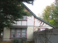 | Reef House | building | 1985 | 85002839 |
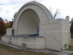 | Riverside Park Bandshell | structure | 2012 | 12000323 |
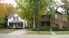 | West Walnut Street Historic District | district | 1975 | 75000664 |
 | Woodlawn Cemetery | site | 1985 | 85003219 |
Every wildfire the federal occurrence database records inside this county: 115 of them, burning about 1,194 acres. 4 started naturally and 25 were recorded as arson. Each settlement page carries the fires within five miles of it.
| Reported cause | Fires |
|---|---|
| Debris and open burning | 35 |
| Missing data/not specified/undetermined | 26 |
| Arson/incendiarism | 25 |
| Recreation and ceremony | 12 |
| Railroad operations and maintenance | 5 |
| Natural | 4 |
| Smoking | 2 |
| Power generation/transmission/distribution | 2 |
| Equipment and vehicle use | 2 |
| Misuse of fire by a minor | 1 |
| Fireworks | 1 |
The five largest, by the area the report gives. Five of them were set deliberately.
| Date | Cause | Size | Reported by | Name on the report |
|---|---|---|---|---|
| 8 November 2010 | Arson/incendiarism | 409 acres | Shawnee National Forest | GRASSY KNOB |
| 27 November 1995 | Arson/incendiarism | 102 acres | Shawnee National Forest | RATTLESNKAE FERRY |
| 27 November 1995 | Arson/incendiarism | 46 acres | Shawnee National Forest | WHISKEY RIDGE |
| 19 March 1995 | Debris and open burning | 44 acres | Shawnee National Forest | HOG HILL |
| 19 November 1999 | Debris and open burning | 41 acres | Shawnee National Forest | SHOAL CREEK |
| 28 June 2005 | Debris and open burning | 40 acres | Shawnee National Forest | HARRY O TWO |
| 26 March 2001 | Arson/incendiarism | 38 acres | Shawnee National Forest | OAKWOOD |
| 22 November 1995 | Arson/incendiarism | 37 acres | Shawnee National Forest | HOWARDTON |
Every settlement page carries the fires within five miles of it - see the settlement index below.
The NOAA Storm Events Database holds 582 reports for this county, causing 13 deaths, 220 injuries and about $121,554,100 in recorded property damage. Each settlement page carries the reports that name it.
| Kind of event | Reports |
|---|---|
| Thunderstorm Wind | 236 |
| Hail | 148 |
| Flood | 90 |
| Flash Flood | 44 |
| Tornado | 39 |
| Heavy Rain | 12 |
| Funnel Cloud | 10 |
| Lightning | 3 |
The most serious of them, by death, then injury, then recorded damage. The accounts are quoted exactly as the forecast office filed them.
| When | Event | Place named | Harm | What the report says |
|---|---|---|---|---|
| December 1957 | Tornado (F4) | not stated | 11 killed, 180 hurt, $2,500,000 | no account filed |
| May 2009 | Thunderstorm Wind | Neunert | 1 killed, 6 hurt, $100,000,000 | Widespread wind damage occurred across Jackson County. Widespread damage to trees, power lines, and structures occurred as the comma head of a bow echo moved east across the county. In the city of Carbondale alone, officials reported 34 properties were deemed total losses from the storm. All but nine of those properties were mobile homes. Damage in the city alone (excluding Southern Illinois University) was estimated near 3 million dollars. Officials estimated about 3,000 trees were down or damaged in Carbondale alone, including the campus of Southern Illinois University. Officials in Murphysboro reported 17 dwellings in that city were total losses. One mobile home was blown over onto a car. Murphysboro officials also reported a police cruiser, a truck, and a mobile command center were destroyed. The city's public works garage was shifted off its foundation, and the city police station was damaged. The peak gust recorded by the automated system at the Carbondale airport was 81 mph before the system failed. An observer at the airport visually observed a separate anemometer located on the rooftop reach 106 mph. The automated system measured a sustained wind of 68 mph before failing. Numerous permanent structures and vehicles were damaged countywide. Small outbuildings were destroyed. The roof of a school collapsed. Carbondale was virtually impassable due to debris. One fatality occurred on Old Route 13 in Murphysboro when a large tree limb fell on a home, knocking an elderly man down a flight of stairs and causing a severe head injury. Emergency responders were delayed by blocked roads. A state disaster declaration was granted for Jackson County. A curfew and state of emergency was declared. Cleanup was expected to take most or all of the summer. Hundreds of trees were blown down in parks, which were closed indefinitely. The preliminary damage estimate for Southern Illinois University was 5 million dollars. Many buildings on campus sustained roof damage. The storm blew out nearly 100 windows in residence halls. Countywide, efforts to restore power were complicated by swampy fields, mud, and downed trees. Eighty-seven percent of the county was without power at the peak of the outages. Widespread power and telephone outages complicated recovery efforts. Most roads were blocked by debris and downed trees. Gas stations were closed in many areas, adding to problems obtaining fuel for generators. Red Cross shelters were opened in Carbondale and Murphysboro. Major grocery stores were closed for at least 12 to 24 hours, and much of their frozen food was lost. Most communication by cell phone and land line was impossible. |
| March 2007 | Lightning | Carbondale | 1 killed | An 18-year-old high school student was struck and killed by lightning at a track meet. The lightning strike occurred on the school's campus just before the start of the track meet. Witnesses stated there was little rain, thunder, or lightning prior to the fatal strike. The student was declared dead on arrival at the hospital. |
| November 1951 | Tornado (F2) | not stated | 7 hurt, $250,000 | no account filed |
| April 1958 | Tornado (F3) | not stated | 6 hurt, $250,000 | no account filed |
| April 1958 | Tornado (F3) | not stated | 5 hurt, $250,000 | no account filed |
| June 1970 | Tornado (F2) | not stated | 5 hurt, $25,000 | no account filed |
| December 1957 | Tornado (F2) | not stated | 5 hurt, $25,000 | no account filed |
| October 2001 | Thunderstorm Wind | Vergennes | 2 hurt, $50,000 | At Vergennes, a camper was blown over on Route 127, injuring two occupants. At Dowell, trees and tree limbs were blown down, some of which landed on houses and vehicles. Near Elkville, a mobile home was reportedly overturned, and at least one barn was destroyed. A few utility poles were snapped. |
| September 2006 | Tornado (F2) | Gorham | 1 hurt, $800,000 | This tornado crossed the Mississippi River from Perry County, Missouri. The tornado weakened from its maximum F-4 intensity to F-2 intensity by the time it entered Jackson County in the Mississippi River bottomlands near Wilkinson Island. At this location, the wall of an old two-story farmhouse was blown out, and the roof was blown off. Hundreds of trees were broken off. Tree damage was visible across the river in Perry County, Missouri. The path width was estimated to be 200 yards wide on the Jackson County side of the river. Before reaching Illinois Route 3, the F-2 tornado widened to 250 yards and destroyed a mobile home. A resident of the mobile home was sent to the hospital. Nearby, a house was unroofed, and trees were snapped or uprooted. Another house lost a room that was added on. A swing set was blown 200 yards and wrapped around a mailbox. An empty tractor trailer rig was overturned. An empty grain bin was blown 100 yards into a field. Full grain bins were severely damaged but remained in place. The roof was blown off a brick house. As the tornado crossed Route 3, high tension utility poles were snapped off, hundreds of acres of corn were flattened, and trees were uprooted. Route 3 was closed for nine hours. From Route 3, the tornado proceeded east-northeast through mostly rural areas of the county, including the Kinkaid Lake State Wildlife Area. The tornado weakened to F-0 intensity before reaching Kinkaid Lake. At the Kinkaid Lake marina, about 50 RV's and boats were damaged, and trees were broken off. The tornado finally lifted shortly after crossing Highway 127 north of Murphysboro. The damage along Highway 127 was about 75 yards wide and consisted of broken tree limbs. A state trooper videotaped the tornado before it lifted. Storm chasers also videotaped the tornado. Peak winds where F-2 damage occurred in western Jackson County were estimated near 150 MPH. The average path width was about 150 yards. A total of about six homes were destroyed or severely damaged, and a dozen others were damaged to a lesser degree. Dozens of other non-residential buildings, such as garages, sheds, barns, and carports, were destroyed. Along the path, striations were evident in fields, and scores of utility poles were snapped off. There were numerous reports of debris falling from the sky in neighboring Perry County, Illinois. Debris as large as pieces of siding and roofing was reported in Du Quoin. |
| March 1970 | Tornado (F2) | not stated | 1 hurt, $250,000 | no account filed |
| May 2024 | Tornado (EF1) | Cora | 1 hurt, $75,000 | An EF-1 tornado impacted the the community of Cora in extreme western Jackson County, IL. The tornado began south of Cora where it uprooted a tree in the Mississippi River bottomlands and did roof damage to a nearby barn. Moving north, the tornado did significant tree damage in Cora and did roof, siding, and fascia damage to a few homes. A couple small barns and a carport were destroyed as well. One manufactured home slid about a foot off its foundation. One person caught outside by the tornado was injured by a falling tree limb. The tornado ended immediately north of Cora. Peak winds with this tornado were estimated at 108 mph. |
| June 2010 | Lightning | Carbondale | 1 hurt | A 32-year-old woman was struck by lightning in the parking lot of a Wal-Mart store. The main injury was to her leg, which may have sustained muscle damage. She was knocked to the ground when lightning struck the shopping cart she was holding. She lost some hair. |
| February 2017 | Tornado (EF3) | Cora | $6,000,000 | This large tornado entered Jackson County from Randolph County near the community of Rockwood. The tornado originally began near Perryville, Missouri, where it achieved its peak intensity in the EF-4 category. The tornado crossed the entire width of Jackson County, entering the county about two miles from the Mississippi River. The tornado passed just south of Ava, clipped the southern edge of Vergennes, and then passed near the north edge of Elkville before exiting the northeast corner of the county. In Jackson County, the tornado reached a maximum intensity of EF-3 on the south end of Vergennes. Winds estimated near 145 mph destroyed a house. The wood house was not securely anchored to the foundation, and other construction details suggested wind speeds were below the EF-4 category. Elsewhere in Jackson County, the tornado passed through mainly rural farmlands and woods. Thousands of large trees were snapped and uprooted, and dozens of homes and other structures were damaged or destroyed. The tornado remained quite wide, nearly one-third of a mile at times. The average path width in Jackson County was about 600 yards. The tornado continued east-northeast into Franklin County. |
| March 2008 | Flood | Ava | $1,800,000 | A large mobile home park east-northeast of Carbondale was flooded due to Crab Orchard Creek. Water was up to the bottom of mobile homes, and vehicles were submerged. Over 100 people were evacuated from the park. A business in Carbondale had two to six feet of water on the first floor. A two-day power outage affecting several buildings at Southern Illinois University was caused by water in manholes. Up to six feet of water was pumped out of a manhole before repairs could start. The small community of Makanda was cut off by flooded roads. A number of roads were closed by flooding, including Route 13, the main east-west artery through the county. At least one water rescue was conducted. About 30 basements were flooded in Murphysboro. |
| April 2011 | Thunderstorm Wind | Carbondale | $1,200,000 | About one-third of the roof was blown off a brand new police station, landing on three nearby homes. The police station suffered water damage, and the nearby homes were heavily damaged. There were numerous trees and power lines blown down in the city. On the Southern Illinois University campus, windows were broken at an academic building, and a tree landed on a residence hall. Carbondale city schools were closed the following day since thousands of utility customers remained without power. |
| January 2016 | Flood | Grand Tower | $1,000,000 | Mississippi River levels continued their climb from December, and record or near-record flooding occurred early in the month. The river gage at Thebes downriver in Alexander County crested at a new record of 47.74 feet on the 2nd. However, the river gage upriver at Chester in Randolph County did not break a record. A voluntary evacuation of the community of Grand Tower was requested, partly due to weaknesses in the levees along the Mississippi and Big Muddy Rivers. Grand Tower sits at the confluence of the Big Muddy and Mississippi Rivers. A Red Cross shelter was opened at Murphysboro. Illinois state highway department crews transported 50,000 sandbags and 100 rolls of plastic for stabilization of slides on a levee. Four state trucks were used to haul rock to low places that needed to be raised up. Illinois Route 3 was closed at the Randolph County line due to flooding. County leaders signed a disaster declaration for the county. |
| May 2002 | Hail | Grand Tower | $1,000,000 | no account filed |
| April 1996 | Thunderstorm Wind | Murphysboro | $1,000,000 | no account filed |
| May 2011 | Flood | Boskydell | $350,000 | no account filed |
| March 2025 | Tornado (EF0) | Vergennes | $300,000 | An EF-2 tornado began near Blacklock Road northwest of Vergennes, and then moved north northeast into Perry County at Zolter Road. The tornado mainly passed over open fields, but did destroy or damage several barns. The estimated peak wind was 110 mph. |
| January 2016 | Flood | Grand Tower | $250,000 | Major flooding of the Big Muddy River continued into January. At the Murphysboro river gage, the river crested at 36.11 feet before dawn on the 2nd. Flood stage there is 22 feet. At Murphysboro, floodwaters approached the flood level of 2008, when the river crested at 37.19 ft on March 23. A mobile home park, a few houses, and a church were flooded or threatened. Sandbagging was done around some affected structures. A Murphysboro couple was rescued by police and firefighters after they were trapped in their home by high water. Extensive flooding of low-lying fields occurred. The intersection of 3rd and Plum Streets in Murphysboro was closed. Floodwater covered the ground below an electrical substation. Slides or slumps developed along a portion of the levee near Grand Tower, prompting concerns about levee failure. Residents were asked to voluntarily evacuate a large area behind the levee. The situation around Grand Tower was heavily affected by backwater from the Mississippi River, which was near record high levels. |
| May 1996 | Flash Flood | Murphysboro | $200,000 | no account filed |
| January 2000 | Thunderstorm Wind | Carbondale | $150,000 | Thunderstorm winds estimated over 100 MPH destroyed a brick home and numerous outbuildings. Several homes were partially damaged from fallen trees. The path of this thunderstorm downburst extended into nearby northwest Williamson County near Cambria. |
| June 2019 | Flood | Grand Tower | $100,000 | Major flooding of the Mississippi River continued through the month of June. The county was included in a disaster proclamation issued by the governor. There was extensive flooding of low-lying farmland and woods. Numerous county roads were inundated. Levees began to show signs of stress due to the extended duration of the flood, which began in March. Sinkholes and sand boils developed along the levee protecting Grand Tower, which prompted emergency repairs. |
| April 2017 | Flash Flood | Carbondale | $100,000 | More than 150 students on the campus of Southern Illinois University were evacuated to other buildings after a dormitory was flooded. Another campus building sustained minor basement flooding. Widespread street flooding occurred, especially in the more densely populated sections of Carbondale. The eastbound lanes of Route 13 were closed in Carbondale due to high water. Nearly every road in one large neighborhood was impassable. Much of the community of Makanda was flooded, where a newly constructed bridge in the middle of town was completely underwater. |
| May 2012 | Hail | Murphysboro | $100,000 | Golf-ball size hail damaged cars, roofs, and siding. |
| February 2012 | Tornado (EF2) | Makanda | $100,000 | The tornado passed into southeast Jackson County from Union County. The tornado was only on the ground for a short time in Jackson County before it lifted. The damage path ended in Giant City State Park. Thousands of trees were snapped or uprooted. Barns and grain bins were destroyed, along with downed power lines. Peak winds were estimated near 115 mph. The average path width was 250 yards. |
| May 2009 | Hail | De Soto | $100,000 | Hail ranging from quarter to golf-ball size affected the Carbondale area north to DeSoto. Quarter to half-dollar size hail fell in DeSoto. On the east side of Carbondale, at least ten car windshields were broken by golf-ball size hail. Hail from one to one-and-one-half inches in diameter was reported on the west and north sides of Carbondale. |
| December 2008 | Thunderstorm Wind | Murphysboro | $100,000 | Utility poles and numerous trees were down in and around the city. At least one tree fell on a vehicle with persons inside. At least one other vehicle was damaged by a falling tree. |
| January 2008 | Thunderstorm Wind | Murphysboro | $100,000 | Widespread damage was reported throughout the county. Rooftop heating units were damaged. A trailer was blown off of its foundation, and numerous trees were down countywide. The wind gusted to 73 mph at the middle school in Murphysboro. The automated observing system at the Carbondale airport measured a peak wind of 73 mph. Trees were down throughout Murphysboro. Minor damage was reported to several homes and businesses in town, mainly to roofs. |
| October 2007 | Thunderstorm Wind | Murphysboro | $100,000 | In Murphysboro, windows were blown out of two structures. In Carbondale, a tree was down on two cars. One of the cars received major damage, and the other received only minor damage. In addition, a power pole was broken, a window was broken, and a couple of trees fell on power lines. In Desoto, a tree fell through the front of a vacant house. The house was destroyed by the 10-foot diameter tree. Power lines and at least one other large tree were down in Desoto. Tree debris was on roadways at nearly 20 locations, mostly in Carbondale. Numerous roads south of Carbondale were temporarily closed due to fallen trees. |
| January 1999 | Flash Flood | Countywide | $100,000 | A series of supercell thunderstorms formed a procession over southwest Illinois throughout the evening hours of January 21. Rainfall amounts of 4 to 7 inches were quite common across Union and Jackson Counties between 6 P.M. and midnight. Anna reported 6.7 inches and Carbondale had 4.00 inches. Numerous roads were flooded. Damage to bridges and vehicles was reported. |
| June 1998 | Flash Flood | Carbondale | $100,000 | no account filed |
| April 1996 | Flash Flood | Murphysboro | $100,000 | no account filed |
| May 2009 | Tornado (EF1) | Sato | $80,000 | Dozens of large trees were snapped or uprooted. Structural damage occurred to two barns, mainly in the form of roof damage. Power poles were blown over, and one pole snapped. Houses received minor shingle damage. Peak winds were estimated near 95 mph. |
| July 2024 | Thunderstorm Wind | Gorham | $75,000 | Numerous mature trees and powerlines were downed in and around Murphysboro as a surging segment of a thunderstorm line moved northeastward through the area. Several trees fell across roads in Jackson County including in Gorham. |
| May 2017 | Flood | Johns Spur | $75,000 | Major to historic flooding occurred on the Big Muddy River. At the Murphysboro river gage, the river crested about two feet below the record of 40.47 feet, which was set in the spring of 2011. The crest of 38.56 feet was recorded on the evening of the 5th. Flood stage is 22 feet. Residents of a mobile home park were asked to voluntarily evacuate. A few residences in Murphysboro were flooded. A church on Route 127 was flooded. Sandbagging was done around some affected structures. Extensive flooding of low-lying fields occurred. A city street intersection in Murphysboro was closed. Floodwater covered the ground below an electrical substation. |
| March 2012 | Tornado (EF1) | Dowell | $75,000 | The tornado began 3.5 miles northwest of De Soto along Truax Traer Road and traveled northeast to 3.5 southeast of DuQuoin. Dozens of trees were uprooted and snapped. One barn was destroyed and several sheds and carports were damaged. A few homes had minor damage to siding and roof shingles. The tornado was observed and recorded by numerous spotters and citizens. Peak winds were about 90 mph. |
| April 2011 | Tornado (EF0) | Elkville | $70,000 | The weak tornado destroyed several carports, a small camper, and a small garage in Dowell. Numerous trees were uprooted. Numerous homes and barns received some roof damage. An amateur radio tower was bent over. Peak winds were estimated near 75 mph. The average path width was 50 yards. |
| June 2018 | Thunderstorm Wind | Elkville | $60,000 | Widespread wind damage occurred across the county. Multiple trees were down, causing widespread power outages. A wind gust to 67 mph was recorded by the automated observing system at the Southern Illinois Airport near Carbondale. Power poles were down. Some roads were blocked by downed trees, including Old Route 13. |
| July 2023 | Thunderstorm Wind | Murphysboro | $50,000 | Multiple trees and large tree limbs were knocked down across town, some of them onto cars and several structures. A road sign was also blown across the road. |
| June 2019 | Flood | Mt Carbon | $50,000 | Lower portions of the Big Muddy River remained above flood stage from mid March through the month of June. The flooding was due almost entirely to backwater from the swollen Mississippi River, which experienced major flooding. The highest crest during June at the Murphysboro gage was 31.72 feet on the 11th. This crest falls into the moderate flood category. Low-lying woods and fields near the river were flooded, along with sections of a riverfront park. A few streets near the river were flooded. Near the confluence of the Big Muddy and Mississippi Rivers, a levee was compromised, prompting emergency repairs. |
| July 2019 | Thunderstorm Wind | Barr | $50,000 | A National Weather Service damage survey was conducted on the west side of Carbondale along Highway 13. The survey determined that a microburst with peak winds near 85 mph occurred, along with a brief gustnado. The damage path was about 0.6 miles long and 850 yards wide. The gustnado, which is a non-tornadic circulation not connected to the cloud base, was videotaped. The damage consisted of dozens of downed tree limbs and a couple of downed trees. An attached carport was blown from the front of a house. Another house lost several shingles. Two crated four-wheelers were blown over, and a utility trailer was blown over 50 yards. At least one power pole was broken. The gustnado was indicated within the damage along the southeast side of the damage, both by video and within the damage pattern. |
| July 2019 | Flood | Grand Tower | $50,000 | Major flooding of the Mississippi River gradually ended by late July. Flood-fighting efforts in the Grand Tower area were completed after the levees were fortified. Low-lying woods, farmland, and county roads remained underwater early in the month. More detailed damage assessments began after the river fell within its banks late in the month. |
| May 2019 | Flood | Grand Tower | $50,000 | The Mississippi River remained above flood stage through the month of May. There was considerable flooding of low-lying farmland and woods. Some county roads were inundated. Due to the extended duration of the flooding, levees began to show signs of stress. There was concern about the stability of the levees, and seepage became a problem. Some roads nearest the levees began to buckle. |
| February 2012 | Thunderstorm Wind | Makanda | $50,000 | A downburst averaging 1/2 mile wide resulted in thousands of trees being snapped or uprooted in the Devil's Kitchen Lake area, around and east of the Giant City State Park area. Peak winds were estimated near 110 mph. |
| May 2011 | Flood | Grand Tower | $50,000 | Major flooding continued on the Mississippi River from April. Based on data from a river gage in Alexander County, the flood crest of 2011 was among the five highest crests on record. A voluntary evacuation of the community of Grand Tower was requested, partly due to a leak in a levee along the Big Muddy River. Grand Tower sits at the confluence of the Big Muddy and Mississippi Rivers. |
| May 2011 | Flood | Grimsby | $50,000 | Record flooding occurred on the Big Muddy River. At the Murphysboro river gage, the river crested at 40.42 feet on the early morning of May 2. This exceeded the old record set in 1961 by over a foot. Illinois Route 127 was closed at the Big Muddy River bridge near Murphysboro. The river was completely over the bridge on Old Route 13. Residents of a trailer park between Illinois Route 13 and the river were asked to evacuate. Flooding approached a Murphysboro neighborhood. The National Guard was activated to assist with sandbagging. The Murphysboro wastewater treatment plant was sandbagged. About a dozen streets were closed and underwater in Murphysboro. U.S. Highway 51 was reduced to one lane north of Carbondale, backing up traffic for miles. |
| June 2011 | Flood | Grand Tower | $50,000 | The Mississippi River flooding in June was relatively minor compared to the April and May flooding. Several homes remained flooded, along with at least 10,000 acres of farmland. Standing water was observed on both sides of Route 3 in many areas. Several county roads remained closed. The Mississippi River remained too high to raise any of the locks and gates along the levees. As a result, the water from recent heavy rains as well as lingering floodwater from May remained trapped inland. |
| August 2011 | Thunderstorm Wind | Gorham | $50,000 | A roof was blown off a house, and a garage was destroyed. A camper was blown over. Debris was blown onto a main street. |
| April 2006 | Thunderstorm Wind | Murphysboro | $50,000 | Trees and power lines were downed in the Carbondale and Murphysboro areas. The county sheriff department responded to 26 storm-related calls, mostly involving trees on roads or power lines. A tree landed on a car in Murphysboro. A barn was blown down in the county. On Kinkaid Lake northwest of Murphysboro, one of the main boat docks was blown apart, causing several of the attached boats to jam together. More than 20 boats in all had to be moved. |
| November 2005 | Flash Flood | Countywide | $50,000 | Major flash flooding was reported in Makanda, which is in a hilly area near the Union County line. Roads heading in and out of Makanda were closed until the floodwaters receded. A co-operative observer measured 5.15 inches of rain in Carbondale from the overnight and early morning storms. An automated gage in Murphysboro measured 4.25 inches. Traffic was diverted from low-lying areas in Carbondale. Sewers backed up into homes and basements. On the campus of the Southern Illinois University, a couple of rooms in the Physical Plant were flooded. |
| June 1998 | Thunderstorm Wind | (Mdh)Crbndl/Mrfysbro | $50,000 | Trees were blown down in the city of Carbondale. |
| March 1997 | Hail | Murphysboro | $50,000 | no account filed |
| August 2020 | Thunderstorm Wind | Ava | $40,000 | Trees were down on vehicles and roadways in the Ava area. |
| June 2020 | Thunderstorm Wind | Murphysboro | $40,000 | Two barns were damaged. Airborne wood beams punctured the wall and roof of a large metal barn in numerous places. A house roof lost a small section of shingles. Tree and metal roof debris was scattered around. Based on photos, it appeared a microburst produced the small area of damage, which occurred on a bluff along the Big Muddy River. |
| January 2013 | Thunderstorm Wind | Murphysboro | $40,000 | A trailer was thrown into another trailer. One of the trailers was destroyed. A double wide mobile home sustained major damage. |
| July 2004 | Thunderstorm Wind | Murphysboro | $40,000 | Numerous trees and limbs were blown down, especially in the southwest portion of Murphysboro. Power lines were knocked down by the falling trees. Several houses, one trailer, and at least one vehicle were struck by downed trees and limbs. Some of the trees were large trees more than 100 years old. |
| June 1998 | Hail | De Soto | $40,000 | Hail the size of quarters covered the ground at DeSoto. Vehicles were dented by hail in Carbondale. |
The Survey's mineral resources record lists 14 workings inside this county. 2 still produce and 12 are closed or unrecorded. Each settlement page carries the workings within five miles of it.
| Commodity | Workings |
|---|---|
| Stone, Crushed/Broken | 8 |
| Fluorine-Fluorite | 2 |
| Sand and Gravel, Construction | 2 |
| Lead | 1 |
| Stone | 1 |
The least common of them first, because a county's hundredth gravel pit says nothing its first ten did not.
| Where | Site | Commodity | Status | Recorded |
|---|---|---|---|---|
| Carbondale City Pit | Stone | Past Producer | ||
| Minor Lead Occurence No. 1 | Lead | Occurrence | ||
| Jackson County Sand&Gravel Dredge | Sand and Gravel, Construction | Producer | ||
| Lawder Dredge | Sand and Gravel, Construction | Past Producer | ||
| Minor Fluorite Occurence No. 1 | Fluorine-Fluorite | Occurrence | ||
| Minor Fluorite Occurence No. 1 | Fluorine-Fluorite | Occurrence | ||
| Campbell Hill Quarry | Stone, Crushed/Broken | Past Producer | ||
| Fountain Bluff Sandstone Exposure | Stone, Crushed/Broken | Prospect | ||
| Kinkaid Stone Quarry | Stone, Crushed/Broken | Plant | ||
| Limestone Prospect | Stone, Crushed/Broken | Occurrence | ||
| Limestone Prospect | Stone, Crushed/Broken | Occurrence | ||
| Limestone Prospect | Stone, Crushed/Broken | Occurrence | ||
| Unnamed Limestone Quarry | Stone, Crushed/Broken | Past Producer | ||
| Unnamed Limestone Quarry | Stone, Crushed/Broken | Past Producer |
Named settlements recorded in the Geographic Names Information System, each with the topographic sheets covering it. Villages, hamlets and abandoned places alike. Each is shown with the nearest named watercourse or landform and the survey quadrangle it falls on.
Makanda township · 62903 · On Indian Creek · Carbondale quadrangle
22 sheets, 1922 to 1996
Bradley township · 62916 · Willisville quadrangle
20 sheets, 1916 to 1987
No longer a settlement
De Soto township · 62924 · On Crab Orchard Creek · De Soto quadrangle
18 sheets, 1910 to 1987
Pomona township · 62975 · On Sugar Creek · Pomona quadrangle
23 sheets, 1924 to 1996
No longer a settlement
Grand Tower township · 62942 · Near Backbone Ridge · Gorham quadrangle
25 sheets, 1924 to 1994
Sand Ridge township · 62940 · On Kinkaid Creek · Oraville quadrangle
19 sheets, 1910 to 1996
Murphysboro township · 62966 · On Mount Carbon · Murphysboro quadrangle
18 sheets, 1910 to 1987
Murphysboro township · 62966 · On Lewis Creek · Murphysboro quadrangle
18 sheets, 1910 to 1987
Fountain Bluff township · 62950 · Near Hat Island · Altenburg quadrangle
28 sheets, 1918 to 1994
Fountain Bluff township · 62950 · On Matusky Brook · Raddle quadrangle
23 sheets, 1916 to 1994
Murphysboro township · 62966 · Near Mount Carbon · Murphysboro quadrangle
18 sheets, 1910 to 1987
The vanished settlements of Jackson County: the places named above that are no longer on the map.