 Block
From the record
14 National Register listings published here, 4 of them National Historic Landmarks.
Sources: the county history on the Internet Archive · the National Register database, National Park Service
62 topographic sheets cover 34 settlements here, and 14 properties are on the National Register of Historic Places.
14 National Register listings published here, 4 of them National Historic Landmarks.
Sources: the county history on the Internet Archive · the National Register database, National Park Service
Every property in this county listed on the National Register of Historic Places, with the year it was listed and the federal nomination document.
| Photograph | Property | Type | Listed | Reference |
|---|---|---|---|---|
| AME Church | building | 1973 | 73000020 | |
 | Lemuel Allen Farm | building | 2016 | 16000334 |
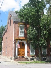 | Crawford-Whitehead-Ross House | building | 1992 | 92001648 |
 | Crowe-Garritt House | building | 1980 | 80000041 |
 | Eleutherian College | building | 1993 | 93001410 |
| Hanover College Historic District | district | 2024 | 100011040 | |
 | Thomas A. Hendricks Library | building | 1982 | 82000043 |
 | Lyman and Asenath Hoyt House | building | 2003 | 03000977 |
 | Jefferson County Jail | building | 1973 | 73000019 |
| Lanier Mansion | building | 1994 | 94001191 | |
| Oakdale School | building | 1993 | 93000432 | |
 | Charles L. Shrewsbury House | building | 1994 | 94001190 |
 | St. Stephen's African Methodist Episcopal Church | building | 2000 | 00001544 |
 | Mathias Wolf Farm | building | 2016 | 16000335 |
Every wildfire the federal occurrence database records inside this county: 20 of them, burning about 239 acres. None started naturally and 2 were recorded as arson. Each settlement page carries the fires within five miles of it.
| Reported cause | Fires |
|---|---|
| Missing data/not specified/undetermined | 5 |
| Recreation and ceremony | 5 |
| Debris and open burning | 3 |
| Equipment and vehicle use | 3 |
| Arson/incendiarism | 2 |
| Smoking | 2 |
The five largest, by the area the report gives. Two of them were set deliberately.
| Date | Cause | Size | Reported by | Name on the report |
|---|---|---|---|---|
| 9 March 2020 | Missing data/not specified/undetermined | 182 acres | Big Oaks National Wildlife Refuge | MISS FIRE IN-BOR SPRING 2020 |
| 8 August 2012 | Equipment and vehicle use | 30 acres | Big Oaks National Wildlife Refuge | BACON RIDGE |
| 15 September 2010 | Missing data/not specified/undetermined | 10 acres | Big Oaks National Wildlife Refuge | HANOVER HILL |
| 16 October 2010 | Smoking | 6.0 acres | Big Oaks National Wildlife Refuge | SUGAN HOLLOW |
| 31 October 2004 | Arson/incendiarism | 3.0 acres | Indiana State Fire Marshal's Office | not named |
| 2 July 2002 | Debris and open burning | 1.0 acres | Indiana State Fire Marshal's Office | not named |
| 25 September 2004 | Arson/incendiarism | 1.0 acres | Indiana State Fire Marshal's Office | not named |
| 15 July 2002 | Equipment and vehicle use | 1.0 acres | Indiana State Fire Marshal's Office | not named |
Every settlement page carries the fires within five miles of it - see the settlement index below.
The NOAA Storm Events Database holds 249 reports for this county, causing 16 deaths, 177 injuries and about $28,548,000 in recorded property damage. Each settlement page carries the reports that name it.
| Kind of event | Reports |
|---|---|
| Thunderstorm Wind | 130 |
| Hail | 35 |
| Flash Flood | 32 |
| Flood | 29 |
| Tornado | 22 |
| Lightning | 1 |
The most serious of them, by death, then injury, then recorded damage. The accounts are quoted exactly as the forecast office filed them.
| When | Event | Place named | Harm | What the report says |
|---|---|---|---|---|
| April 1974 | Tornado (F4) | not stated | 10 killed, 175 hurt | no account filed |
| March 2012 | Tornado (EF4) | Chelsea | 4 killed, $750,000 | The tornado entered Jefferson County as an EF-4 with a damage width of one-third of a mile. Several mobile homes were destroyed along and just north of State Highway 362 near the three-county intersection with Clark and Scott Counties. The tornado severely damaged several frame houses here, extensively damaged many power poles and power lines, and felled many trees. ||After snapping trees and power poles along County Road 850, the tornado did a tremendous amount of damage around 2 miles south of Chelsea near the intersection of State Highway 62 and Swan Road. Here, several well built brick homes were destroyed. The homes had anchor bolts attached to steel plates and a concrete foundation. One home was lifted and slide 65 yards off its foundation while still remaining essentially intact. Another home was demolished and thrown several hundred yards downwind. Three fatalities occurred at this location. Two vehicles from the garage of this home were tossed for several dozen yards. A third well-built brick home had its roof lifted and thrown over 300 yards, and an above-ground pool filled with water was missing. Wind speeds were estimated at around 170 mph with a damage width of one quarter of a mile. ||Through the rest of Jefferson county, the tornado did extensive damage to forests as it tracked to the north of Paynesville and south of Lee Bottom. The damage path narrowed to 200 yards before exiting Jefferson County and moving over the Ohio River. |
| September 1976 | Tornado (F3) | not stated | 1 killed, 1 hurt, $250,000 | no account filed |
| September 2022 | Flash Flood | Manville | 1 killed, $200,000 | A 64 year old woman was killed when water left the banks of Brushy Fork and swept away her house on Brushy Fork Road. A barn and all the family's belongings were also swept away in the flood waters. The body of the woman was found 5 miles downstream by family members after first responders suspended their efforts overnight. The value of the damaged property is unknown. |
| April 1967 | Tornado (F2) | not stated | 1 hurt, $25,000 | no account filed |
| April 1974 | Tornado (F4) | not stated | $25,000,000 | no account filed |
| September 1992 | Tornado (F1) | not stated | $250,000 | no account filed |
| June 1990 | Tornado (F3) | not stated | $250,000 | no account filed |
| June 1990 | Tornado (F3) | not stated | $250,000 | no account filed |
| March 1997 | Tornado (F1) | Blocher | $200,000 | no account filed |
| March 2017 | Thunderstorm Wind | Wakefield | $150,000 | The public reported that a brick home near Rogers Road and Chicken Run Road was completely missing its roof due to severe thunderstorm winds. The residence next to it had half of its roof missing. Many trees in the area were snapped or uprooted. An NWS damage survey team determined the winds to be near 100 mph. This was part of a larger swath of 70+ mph winds that extended in a 1-2 mile wide path from northern Scott into western Jefferson County. |
| August 2002 | Tornado (F1) | Deputy | $100,000 | The tornado path was mainly through a rural section of Jefferson County. F1 damage was noted in and around the town of Deputy, with estimated wind speeds of 100 mph. Several roofs were lifted off structures, and eye witnesses reported debris swirling in the air around the tornado. Debris consisted primarily of boards and limbs. Numerous trees were torn down and laid in varying directions along the tornado path. |
| August 2002 | Thunderstorm Wind | Deputy | $100,000 | Roofs were blown off several houses in Deputy. |
| April 1999 | Tornado (F2) | Dupont | $100,000 | no account filed |
| May 2004 | Thunderstorm Wind | Madison | $80,000 | A barn was destroyed by thunderstorm winds. |
| May 2017 | Tornado (EF1) | Pleasant Pt | $75,000 | A small tornado touched down just north of West Galway Trail N in a tree line behind some houses. The tornado uprooted and snapped trees as it moved east. An eyewitness reported seeing a black mass with debris moving horizontally. The tornado covered his house in fallen trees. As it crossed Paper Mill Road, the inflow winds into the tornado pulled off siding from nearby houses and moved light objects several hundred feet. A camper parked on the southern edge of the path rolled three times toward the center of circulation and was destroyed. After crossing the road it struck an abandoned farm house and did more tree damage. There was no more evidence of damage after the tornado passed east of the farmhouse. |
| July 2015 | Flash Flood | Madison | $75,000 | A broadcast media meteorologist relayed a report of 5 to 10 water rescues that occurred in Madison as a result of flash flooding. Approximately 5,000 residences and businesses lost power as well. |
| May 2017 | Thunderstorm Wind | North Madison | $50,000 | A trained spotter reported roof damage to a consignment shop. |
| July 2015 | Thunderstorm Wind | Brooksburg | $50,000 | A broadcast media meteorologist relayed a report that several barns were destroyed by severe thunderstorm winds. |
| April 2006 | Thunderstorm Wind | Madison | $50,000 | A barn was destroyed. |
| June 2002 | Lightning | Brooksburg | $50,000 | A lightning strike caused a fire that destroyed most of a restored log cabin. |
| May 1996 | Thunderstorm Wind | Deputy | $50,000 | no account filed |
| January 2012 | Tornado (EF0) | Smyrna | $40,000 | A person witnessed a weak tornado that damaged an airplane and a hanger at the Madison Municipal County Airport. Damage occurred along IMS Lane. A 500 pound dumpster was moved 35 feet. A Beechcraft twin engine plane was rotated 10 degrees, losing its nose gear in the process. The airport operations building had a disabled awning. A portion of a hanger's siding came off with some siding and insulation found in trees. Several trees were toppled. Maximum winds were estimated to be 85 mph. |
| August 2002 | Thunderstorm Wind | Deputy | $40,000 | Trees were blown on to a house in Deputy. |
| May 2017 | Thunderstorm Wind | North Madison | $35,000 | A trained spotter reported severe thunderstorm wind damage to the awning over a fuel station. |
| July 2015 | Flash Flood | Antioch Grange | $30,000 | A broadcast media meteorologist relayed a report of a mud slide at Hanover Hill due to flash flooding. Between 3 and 5 inches of rain fell in the area. |
| March 2008 | Flash Flood | Deputy | $30,000 | Sections of State Road 250 and Deputy Pike were closed due to high water. Three vehicles were submerged in high waters. The occupants were rescued. |
| May 2017 | Thunderstorm Wind | Wirt | $25,000 | The Jefferson County emergency manager reported trees and power lines down on State Road 7 near Dawson Smith Road. |
| April 1985 | Tornado (F2) | not stated | $25,000 | no account filed |
| October 1965 | Tornado (F2) | not stated | $25,000 | no account filed |
| July 2017 | Thunderstorm Wind | Hanover | $20,000 | The public reported downed trees on some homes. |
| July 2015 | Thunderstorm Wind | Hanover | $20,000 | A broadcast media meteorologist relayed a report that severe thunderstorm winds brought down trees and damaged roofs in the area. |
| July 2018 | Thunderstorm Wind | Dupont Broonsage Arp | $15,000 | Power lines were reported down near Dupont. |
| May 2016 | Thunderstorm Wind | Saluda | $15,000 | Severe thunderstorm winds destroyed a barn along with numerous trees in the area. |
| July 2016 | Thunderstorm Wind | Pleasant Pt | $15,000 | Trees and power poles were reported down in the area due to severe thunderstorm winds. |
| January 2012 | Thunderstorm Wind | Smyrna | $15,000 | A microburst just east of an observed tornado damaged several buildings along Clifty Drive, which is located just east of the Madison Municipal County Airport. A carport at a residence on Long Way was thrown across the street. Farther east, significant roof damage was noted to the main building of the Clifty Engineering and Tool Company in the 2900 block of Clifty Drive. Additional roof damage occurred to a storage building next to the main building. A tree was toppled. This microburst had estimated winds of 90 to 95 mph and developed over an area of 150 by 75 yards. |
| May 2004 | Thunderstorm Wind | Madison | $15,000 | A barn was destroyed by thunderstorm winds. |
| June 2019 | Thunderstorm Wind | Belleview | $10,000 | Multiple trees and power lines were reported down at State Road 250 and Graham Road. |
| July 2015 | Flash Flood | Madison | $10,000 | A broadcast media meteorologist relayed to the NWS that the Madison, Indiana police chief reported 2 high water rescues in Madison. Between 3 and 5 inches of rain fell in the area. |
| August 2013 | Thunderstorm Wind | Smyrna | $10,000 | The Jefferson County emergency manager relayed a report of damage to some shingles and siding of a home northwest of Madison. a few metallic objects were thrown hundreds of feet. Trees were toppled near the intersection of Chicken Run and Borcherding Roads. |
| August 2012 | Thunderstorm Wind | Kent | $10,000 | The Lexington, Kentucky broadcast media reported that thunderstorm winds toppled a tree onto a house just northeast of Lexington, Indiana. |
| April 2002 | Flash Flood | Countywide | $10,000 | Many roads were flooded countywide. Roads and bridges were washed out in the eastern part of the county. Flood waters entered a business on U.S. 421 in Madison. |
| May 2002 | Hail | Madison | $10,000 | Hail covered the ground. An above ground swimming pool was destroyed. |
| July 2013 | Flash Flood | Bryantsburg | $5,000 | Heavy slow-moving thunderstorms developed north of Madison, Indiana during the late evening. These storms were separate from those that earlier brought flooding to locations southwest of Madison. An estimated 2 to 3 inches fell during a 3 hour window during the mid to late evening hours. Law enforcement reported a car stalled on flooded State Highway 421 just south of the Jefferson-Ripley County Line. |
| April 2002 | Thunderstorm Wind | Hanover | $5,000 | Tree branches were blown through windows in homes. A small occupied travel trailer was blown two feet. No one was injured and there was no damage to the trailer. |
| April 2001 | Thunderstorm Wind | Hanover | $5,000 | Siding was blown off several homes. Hail was also reported with this event, but the size was undetermined. |
| July 2012 | Thunderstorm Wind | North Madison | $2,000 | A portion of a metal roof was ripped off by thunderstorm winds just northeast of Madison. |
| August 2018 | Thunderstorm Wind | North Madison | $1,000 | Multiple trees were reported down. |
| March 2026 | Thunderstorm Wind | Antioch Grange | - | There were a couple of trees down at the intersection of State Road 256 and State Road 56. |
| April 2026 | Thunderstorm Wind | Central | - | A tree was blocking North K Road and Old State Road 62. |
| April 2026 | Flash Flood | North Madison | - | Clifty Drive closed at Cragmont Street due to water over the road. |
| April 2026 | Flash Flood | Hanover | - | There were reports of flooding along State Road 56 between Hanover and Madison. |
| April 2026 | Thunderstorm Wind | Central | - | There were several trees and power lines down along Eagle Hollow Road. |
| March 2025 | Thunderstorm Wind | Canaan | - | Multiple trees were blown down near Canaan, including near the intersection of Halls Ridge Road and Lower Dry Fork Road. |
| June 2025 | Hail | Hanover | - | Dime sized hail was observed near the intersection of Thornton Road and Sycamore Drive in Hanover. |
| April 2025 | Thunderstorm Wind | Deputy | - | There were multiple trees down on the 1200 block of 1400 West. |
| April 2025 | Thunderstorm Wind | Wakefield | - | There were multiple trees down on the 2400 block of Rogers Road. |
| March 2024 | Tornado (EF1) | Antioch Grange | - | The National Weather Service in Louisville, KY in coordination with the National Weather Service in Wilmington, OH conducted a 2 day storm damage assessment survey. The survey found a 18.6 mile long EF-2 tornado with peak winds of 115 mph occurred on the afternoon of March 14, 2024. The tornado was on the ground for 26 minutes as it touched down 1 mile north of Hanover, IN, and lifted just east of Carrollton, KY. The tornado crossed the Ohio River three times as it started in Jefferson County, IN, crossed the Ohio River into Trimble County, KY, entered Carroll County, KY, crossed the Ohio River back into Jefferson County, IN, crossed into Switzerland County, IN, and crossed the Ohio River for the last time before entering Carroll County, KY. The tornado was 500 yards wide at its maximum.||The tornado touched down on Paradise Lane off of Highway 256 on the north side of Hanover, Indiana. the tornado caused shingle and gutter damage, and a couple of large limbs down. The tornado was initially 80 mph, EF-0, with a width of 60 yards. It increased to 90 mph, EF-1, on County Manor Boulevard, taking a roof off a home|with sections of the roof twisted around limbs and trees. The width increased to 80 yards.||In the area by Birch St. and Ash Dr, the tornado did sporadic tree damage with a few topped and uprooted trees. The width remained at 80 yards and wind speed were EF-0, 80 mph.||Next the tornado did extensive damage in Jefferson Manor subdivision. Several homes had extensive roof damage and one newer house had the roof completely ripped off. A 1500 pound brick mailbox was knocked over. Several garages sustained major damage|and one outbuilding was destroyed. National Weather Service drone photography showed debris thrown up to an eight of a mile. The tornado was 110 mph, EF-1, with a width of 150 yards at this spot.||The tornado crossed Indiana 56 and did extensive tree damage on South Revonah Dr. Trees were snapped, uprooted, and twisted in multiple directions. Witnesses saw the tornado, had photography, and heard a loud wind and had their ears pop. Wind speeds of 90 mph EF-1, with a width of 200 yards. There were also some uprooted|trees along River Bottom Road. ||The tornado crossed the Ohio River between River Bottom Road on the Indiana side and Coopers Bottom Road on the Kentucky side, just south of the Clifty Creek Power Plant. |
| March 2024 | Tornado (EF2) | Brooksburg | - | The National Weather Service in Louisville, KY in coordination with the National Weather Service in Wilmington, OH conducted a 2 day storm damage assessment survey. The survey found a 18.6 mile long EF-2 tornado with peak winds of 115 mph occurred on the afternoon of March 14, 2024. The tornado was on the ground for 26 minutes as it touched down 1 mile north of Hanover, IN, and lifted just east of Carrollton, KY. The tornado crossed the Ohio River three times as it started in Jefferson County, IN, crossed the Ohio River into Trimble County, KY, entered Carroll County, KY, crossed the Ohio River back into Jefferson County, IN, crossed into Switzerland County, IN, and crossed the Ohio River for the last time before entering Carroll County, KY. The tornado was 500 yards wide at its maximum.||After exiting Carroll County, KY, the tornado crossed the Ohio River for a second time, and increased significantly at the Route 56 Campground. The tornado snapped dozens of trees. The 400 yard wide twister knocked over several RV trailers, and lifting them in the air and wrapping two around trees. The team looked up owner's manuals to determine that actual weight of the various types of trailers. One trailer in particular was a 46-footer, and weighed about 14000 pounds, and was knocked over and moved 5 inches.||Numerous boat ports, had anchor supports pulled out of the ground, including several buried in a foot of concrete. Debris from the RV park was thrown onto Highway 56 and well beyond into the trees on the north side of the highway. Outbuildings and small barns were destroyed. Wind speeds at the RV Park were 115 mph, EF-2.||The tornado crossed in Switzerland county near Green Valley Road. |
| July 2024 | Thunderstorm Wind | Madison | - | Trees down near Main Street in Madison. |
The Survey's mineral resources record lists 4 workings inside this county. 1 still produces and 3 are closed or unrecorded. Each settlement page carries the workings within five miles of it.
| Commodity | Workings |
|---|---|
| Magnesite | 1 |
| Stone, Crushed/Broken | 1 |
| Stone | 1 |
| Sand and Gravel, Construction | 1 |
The least common of them first, because a county's hundredth gravel pit says nothing its first ten did not.
| Where | Site | Commodity | Status | Recorded |
|---|---|---|---|---|
| Concrete Materials Div Ls Quarry | Magnesite | Past Producer | ||
| Indian Kentuck Creek Gravel Pit | Sand and Gravel, Construction | Past Producer | ||
| Jefferson Co. Hwy. Dept. | Stone | Producer | ||
| Jefferson Plant No 3 Quarry & Mill | Stone, Crushed/Broken | Past Producer |
One book written about this county, cut here where the book itself is cut, at its printed chapters: 1 chapter in all. Every chapter is public domain, machine-read from the scan and reproduced complete. A chapter already given under one of the county's towns is not repeated in this list.
| Chapter | Length |
|---|---|
| The whole text | 32,939 words in 3 parts |
Named settlements recorded in the Geographic Names Information System, each with the topographic sheets covering it. Villages, hamlets and abandoned places alike. Each is shown with the nearest named watercourse or landform and the survey quadrangle it falls on.
Shelby township · 47250 · Near Hicks Ridge · Rexville quadrangle
8 sheets, 1956 to 1990
Milton township · 47250 · Near Shirks Hollow · Carrollton quadrangle
12 sheets, 1943 to 1990
Monroe township · 47250 · Clifty Falls quadrangle
10 sheets, 1956 to 1992
No longer a settlement
Hanover township · 47243 · On Happy Valley Creek · Madison West quadrangle
17 sheets, 1939 to 1990
Hanover township · 47243 · On Happy Valley Creek · Madison West quadrangle
17 sheets, 1939 to 1990
Lancaster township · 47250 · On Middle Fork Creek · Volga quadrangle
8 sheets, 1956 to 1990
Madison township · 47250 · Near Dugan Hollow · Madison West quadrangle
17 sheets, 1939 to 1990
Saluda township · 47147 · On Big Saluda Creek · Bethlehem quadrangle
15 sheets, 1939 to 1990
Madison township · 47250 · By Hanging Rock · Clifty Falls quadrangle
10 sheets, 1956 to 1992
The vanished settlements of Jefferson County: the places named above that are no longer on the map.