BlockBefore
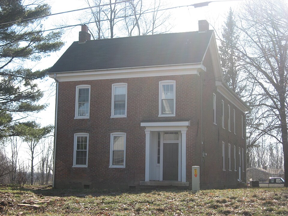
Photograph of John F. and Malissa Koontz House
Photograph by Nyttend, Public domain. Via Wikimedia Commons.

John F. and Malissa Koontz House

Listed on the National Register of Historic Places in 2014.

From the record

“John F. and Malissa Koontz House, also known as the Koontz House and Koontz-Engle House, is a historic home located at Indian Creek Township, Monroe County, Indiana. It was built in 1872, and is a two-story, Greek Revival style brick two-thirds I-house.”

Wikipedia article John F. and Malissa Koontz House, CC BY-SA 4.0.

One of 48 National Register listings published here for Monroe County · listed in 2014 · category: Building.

Sources: the Wikipedia article · the National Register database, National Park Service

The listing

  • Listed as. Koontz, John F. and Malissa, House - the National Register files a house under its owner's surname.
  • Address. 7401 S. Mount Zion Rd., Bloomington, 47403
  • When was it listed? March 2014
  • Category. building
  • Township. Indian Creek township
  • Architectural style. Greek Revival architecture
  • National Register reference number. 14000075 - assigned by the National Park Service when the property was listed.

What happened here

An account from the chapter on Indian Creek township. The inset identifies its exact source book and publication year.

From 1884 History of Monroe County Indiana, published 1884 - Indian Creek Township

Army Correspondence

May, the members of Capt. Kelley's company, Fourteenth Regiment, sent home to their friends $2.000. As this time also the body of Capt. Kelley was brought home and buried. He had been mortally wounded at the hotly contested battle of Winchester, and after lingering several weeks had died at Cincinnati, where he had been brought by his loving and faithful wife for medical treatment.

Read the rest of this passage

The ground it stands on

40,478 words

The chapter on Indian Creek Township in 1884 History of Monroe County Indiana, published 1884 names Bloomington. This is what it says, exactly as the scans read.

Wampler, Thomas Smith, James Matlock, William Julien, William J. Adair, John Kell, C. and F. Bullett, John Owens, Daniel Stout, Samuel Caldwell, Roderick Rollins, Joseph Taylor, David Raymond, Jacob Benderback, Eleazer Dagget, James Borland, Gideon Frisbee, John Lee, William Matlock, Samuel Camphreys, Thomas Graham, Abraham Appler, Chris Esling, George Ritchey, George Hedrick, David Rogers, Henry Rogers, John Thompson, Wheeler Mallett, Samuel Scott, Nicholas Fleener, William Jackson, John Jackson and Thomas Heady. Township 9 north, Range 2 west: Joseph Evans, Asa Osborn, Lewis Noel, Jonathan Gilbert, George Cutler, George Sharp, James Goodwin, Joseph Harris, Ambrose Carlton, John Simons, John Gordon, John McCormick, William Thornton, Abel Bigolow, David Johnson, John Fullen, William Baker, David Sears, Samuel Zunicks, William Oliver, Thomas Hodges and Benjamin Johnson. Township 10 north, Range 2 west: John Fullen about all of Section 4, Abner Evans, Archibald Wood, Jonathan Gilbert, ©. & F. Bullett, Fettus & Hughes, John Mc- Cormick, Julius Woodward, William Milliken, William Kelso, John Bigger, Samuel Jennings, nearly all of whom entered several hundred acres each. No entry was made before September, 1816, and during the remainder of that year entries were only made west of the méridian line and south of the old Indian boundary. These entries were all in the present townships of Clear Creek, Indian Creek, Van Buren, Richland, Bloomington and Bean Blossom. Several tracts weré purchased by speculators, but the greater number passed to actual residents or to those who became actyal residents.

Passage source: 1884 History of Monroe County Indiana, published 1884.

In accordance with the provisions of this enactment, the machinery of the county was immediately put in running order. An election was ordered held under the supervision of the Sheriff, John W. Lee, appointed by the Governor, for the necessary county officers. Bartlett Woodward, Michael Buskirk and James Parks were elected County Commissioners ; William Lowe, County Clerk and Auditor; Chesley Bailey, Recorder ; Joseph Berry and Lewis Noel, Associate Judges. The details of this election cannot be given, as the tally-sheets were not preserved. The election took place early in 1818. 'The house of Abner Blair was the first court house, but Bloomington was immediately laid out and a log court house built. The Commissioners appointed by the Legislature to locate the county seat met, deliberated, and finally submitted the following report to the first County Board:

Passage source: 1884 History of Monroe County Indiana, published 1884.

Machine-read from a century-old scan, so expect the errors a machine makes: misspelled names, dropped words, stray characters.

Read the whole chapter on Indian Creek Township - 40,478 words on its settlement, mills, schools and churches.

Fires near this property

54 since 1993

Regional context, not property-specific evidence. The federal wildfire occurrence database lists 54 fires within 5 miles of John F. and Malissa Koontz House between 1993 and 2013, burning about 50 acres in total. 1 started naturally. 5 were recorded as arson. Distance is straight-line from the map coordinates, so a fire counted here may appear on a neighbouring settlement's page as well.

Reported cause Fires
Recreation and ceremony19
Debris and open burning19
Missing data/not specified/undetermined6
Arson/incendiarism5
Smoking2
Natural1
Equipment and vehicle use1
Other causes1

The most recent of them, most recent first, with the day each was reported and the service that recorded it.

DateCause SizeReported by Name on the report
9 September 2005Debris and open burningunder an acreIndiana State Fire Marshal's Officenot named
7 September 2007Missing data/not specified/undeterminedunder an acreIndiana State Fire Marshal's Officenot named
3 September 2007Arson/incendiarismunder an acreIndiana State Fire Marshal's Officenot named
23 September 2005Naturalunder an acreIndiana State Fire Marshal's Officenot named
20 September 2007Debris and open burning1.0 acresIndiana State Fire Marshal's Officenot named
15 September 2006Recreation and ceremonyunder an acreIndiana State Fire Marshal's Officenot named
4 August 2007Arson/incendiarismunder an acreIndiana State Fire Marshal's Officenot named
27 August 2007Recreation and ceremonyunder an acreIndiana State Fire Marshal's Officenot named

Every fire recorded in Monroe County

Mines and quarries near this property

10 of 17 shown

Regional context, not property-specific evidence. The federal mineral resources record lists 17 workings within 5 miles of John F. and Malissa Koontz House: 10 occurrences, 5 past producers, 2 producers. 2 still produce. What was taken out: Iron, Limestone, Dimension, Limestone, General. Distance is straight-line from the map coordinates, so a quarry counted here may appear on a neighbouring settlement's page as well.

Where SiteCommodity StatusRecorded
Cleveland Stone Limestone QuarryLimestone, GeneralPast Producer
4-R QuarryLimestone, DimensionPast Producer
Beck QuarryLimestone, DimensionPast Producer
Independent Limestone CompanyLimestone, DimensionProducer
Monarch QuarryLimestone, DimensionPast Producer
Shawnee QuarryLimestone, DimensionPast Producer
Victor Oolitic Stone CompanyLimestone, DimensionProducer
Unnamed ProspectIronOccurrence

Every working recorded in Monroe County

Storms near this property

60 of 109 shown

Regional context, not property-specific evidence. The National Weather Service names Bloomington, the town this property stands in, in 109 storm reports between 1994 and 2026: 52 thunderstorm wind, 44 hail, 5 flash flood, 4 flood. The reports record 1 death and 3 injuries. Each account below is quoted exactly as the forecast office filed it, from the NOAA Storm Events Database, and each date opens the federal record of that event.

WhenEvent Place namedHarm What the report says
October 2000Flash FloodBloomington1 killedno account filed
June 2008LightningBloomington3 hurtTwo individuals had lightning strike near them and were taken to the hospital for lighting related injuries. The cell phone of another individual was stuck while the person was talking on the phone. This individual was also taken to the hospital for treatment.
June 2024Thunderstorm WindBloomington$5,000,000Widespread significant tree damage across the city of Bloomington with numerous reports of property damage due to fallen trees and tree limbs.
April 2000Thunderstorm WindBloomington$200,000no account filed
May 2004Tornado (F0)Bloomington$150,000An F0 tornado moved across Lake Monroe southeast of Bloomington sinking several sailboats.
June 1998Thunderstorm WindBloomington$60,000Thunderstorm winds to 70 mph blew down dozens of trees and power lines. Up to four homes and several vehicles were damaged by fallen trees.
August 2004Thunderstorm WindBloomington$30,000Trees were downed in several locations across Bloomington, including one that crushed a car and another that fell on a barn. Damage amounts were estimated.
April 2006Thunderstorm WindBloomington$20,000Trees fell on a house.
May 2011Thunderstorm WindBloomington$15,000Several large trees were reported down due to damaging thunderstorm wind gusts.
May 2011Thunderstorm WindBloomington$15,000Multiple trees were reported down across Bloomington due to damaging thunderstorm wind gusts.
May 2011Thunderstorm WindBloomington$12,000Many trees and limbs were reported down due to damaging thunderstorm wind gusts.
September 2014Thunderstorm WindBloomington$10,000Trees were downed and a few homes sustained minor damage in an eastside Bloomington neighborhood.
January 2012Thunderstorm WindBloomington$9,000Three trees were blown down along State Route 45 due to damaging thunderstorm wind gusts. Two of the downed trees were at the intersection of State Route 45 and Russell Road. The other downed tree was just southwest of town. Two of the three trees looked healthy. Both instances of trees down at State Route 45 and Russell Road hit homes and caused minor roof damage.
August 2023Thunderstorm WindBloomington$5,000Thunderstorm winds caused tree damaged in Bloomington.
June 2010Thunderstorm WindBloomington$5,000Trees, up to 10 inches in diameter, were reported down due to damaging thunderstorm wind gusts on Moores Pike.
June 2010Thunderstorm WindBloomington$5,000Trees, up to 10 to 14 inches in diameter, were reported down due to damaging thunderstorm wind gusts in this location.
June 2008Flash FloodBloomington$5,000Roadways were covered and previous flooding conditions were exacerbated due to heavy rainfall that caused renewed flash flooding.
April 1994Thunderstorm WindBloomington$5,000An automobile was totaled after a large tree fell on top of it.
April 2011Flash FloodBloomington$2,000Multiple intersections were reported to be flooded with water up to about a foot deep.
June 1995Thunderstorm WindBloomington$2,000Trees and power lines were downed on the east side of Bloomington.
June 1995Thunderstorm WindBloomington$2,000Trees and power lines were downed in Bloomington.
February 2014FloodBloomington$1,000Streets were reported to be flooded due to heavy thunderstorm rainfall. The campus bus routes were suspended.
June 2009Flash FloodBloomington$1,000Streets were reported to be flooded in Bloomington due to thunderstorm heavy rainfall.
June 2009Flash FloodBloomington$1,000Flash flooding of some county roads were reported throughout Monroe County due to thunderstorm heavy rainfall. A few intersections in Bloomington were flooded as well. The location of this event is estimated.
May 2002Thunderstorm WindBloomington$1,000Trees down
May 1996Thunderstorm WindBloomington$1,000no account filed
March 1996Thunderstorm WindBloomington$1,000no account filed
July 2008Thunderstorm WindBloomington$800Thunderstorm winds blew a tree down.
June 2015FloodBloomington$500Some minor street flooding was reported in this location due to heavy rainfall.
July 2013Thunderstorm WindBloomington$500A trained spotter reported several tree branches down due to an estimated 60 mph thunderstorm wind gust.
January 2012FloodBloomington$500Heavy thunderstorm rainfall caused 3.5 inches of standing water at the intersection of 3rd and Jordan Streets.
August 2004Tornado (F0)Bloomington$500A very small and brief tornado touched down from a thunderstorm near Bloomington, causing damage to several trees in the backyard of a residence. No one was injured, and no other significant damage was reported.
May 2011Thunderstorm WindBloomington$200A four inch diameter tree branch was reported down at 10th and Walnut Streets.
June 2025Thunderstorm WindBloomington-Trained spotter estimated thunderstorm wind gusts up to 70 mph.
June 2024Thunderstorm WindBloomington-A 60 mph thunderstorm wind gust was measured at this location.
April 2024HailBloomington-Mainly 0.88 inch or smaller hail across Monroe County, included one golf ball sized hailstone, which was likely advected from the cluster's main updraft crossing southeastern portions of Monroe County. One-inch hail was also reported near and southeast of Bloomington.
June 2023HailBloomington-Thunderstorm hail continued, as large as quarters in Bloomington.
July 2023HailBloomington-Nickel sized hail on north side of Bloomington. Numerous reports of 0.50-0.75 inch hail from south of Ellettsville, through Bloomington, to near/southwest of Woodville Hills.
May 2017HailBloomington-This report was received via Facebook.
March 2012HailBloomington-The hail lasted for 10 minutes.
April 2011Thunderstorm WindBloomington-A thunderstorm wind gust, estimated at 60 mph, was reported in Bloomington.
May 2011Thunderstorm WindBloomington-A 70 to 80 mph thunderstorm wind gust was reported in this location, with much debris.
August 2011Thunderstorm WindBloomington-An estimated 60 mph thunderstorm wind gust was observed in this location. Pea-sized hail was also observed.
August 2009Thunderstorm WindBloomington-A spotter estimated thunderstorm wind gusts between 60 to 70 miles per hours in Bloomington.
January 2008Thunderstorm WindBloomington-The wind gust was measured by ASOS equipment.
April 2007Thunderstorm WindBloomington-Trees were reported down in several places due to damaging thunderstorm winds.
March 2006FloodBloomington-Two roads were closed due to high water. No property damage was reported.
April 2006HailBloomington-No property damage estimates were available.
May 2005Thunderstorm WindBloomington-Several trees were blown down.
May 2005Thunderstorm WindBloomington-Trees were downed near Bloomington.
May 2005Thunderstorm WindBloomington-Power lines were blown down at the south end of Lake Monroe.
June 2005Thunderstorm WindBloomington-Trees were blown down.
July 2005Thunderstorm WindBloomington-Large tree limbs fell.
November 2005Thunderstorm WindBloomington-Trees were downed.
July 2004Thunderstorm WindBloomington-A large tree was downed.
July 2004Thunderstorm WindBloomington-Trees were downed.
July 2003Thunderstorm WindBloomington-Trees down in Harrodsburg
May 2002Thunderstorm WindBloomington-Large limbs down
April 2002HailBloomington-Hail covered the ground

Every storm recorded in Monroe County

Map coverage status

No historic map-sheet match is published for this property yet. That does not mean no map exists. This record needs a coordinate-quality review before it can be joined to a sheet boundary. Browse the county's mapped places while that work is pending.

Listed places nearby

6 within 8 miles

Other National Register properties close enough to walk or drive between, ordered by distance from this one. Both positions come from the same geocoding pass that matched these properties to their map sheets.

Photograph PropertyDistance Listed
Joseph Mitchell House4.1 miles1986
Stipp-Bender Farm4.9 miles2023
Carter-Randall-Parker House6.0 miles2018
Woolery Stone Company6.1 miles2002
Tate-Tatum Farm6.3 miles2020
Leroy Mayfield House6.9 miles1994

Sources for this property

National Archives recordThe nomination case file for reference 14000075 in Record Group 79.
Wikipedia articleCommunity-written account of this property, licensed CC BY-SA.
Monroe CountyAll 48 listed properties in this county.

Provenance

  • Listing record. National Park Service National Register of Historic Places, listed-properties dataset, current to 2026-05-22.
  • Map join. Address geocoded through the United States Census geocoder, then tested against the published boundary of every sheet in the USGS Historical Topographic Map Collection.
  • How this page is made. Listing fields come from federal records; map-sheet coverage is a labelled coordinate-to-boundary calculation, not a source-field claim.
  • Wildfire. Short, Karen C. 2022. Spatial wildfire occurrence data for the United States, 1992-2020 [FPA_FOD_20221014]. 6th Edition. Fort Collins, CO: Forest Service Research Data Archive. https://doi.org/10.2737/RDS-2013-0009.6 Collected with United States Government funding and usable without additional permissions or fees.
  • Mines and quarries. USGS Mineral Resources Data System (MRDS) https://mrdata.usgs.gov/mrds/ A work of the United States government, no copyright under 17 U.S.C. 105.
  • Storms. NOAA National Centers for Environmental Information, Storm Events Database https://www.ncei.noaa.gov/stormevents/ A work of the United States government, no copyright under 17 U.S.C. 105. Narratives are quoted verbatim from the National Weather Service report and are not edited or summarised.