 Block
From the record
2 National Register listings published here.
Sources: the National Register database, National Park Service
21 topographic sheets cover 10 settlements here, and 2 properties are on the National Register of Historic Places.
2 National Register listings published here.
Sources: the National Register database, National Park Service
Every property in this county listed on the National Register of Historic Places, with the year it was listed and the federal nomination document.
| Photograph | Property | Type | Listed | Reference |
|---|---|---|---|---|
 | Bank of Oberlin | building | 1994 | 94001418 |
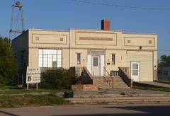 | Norcatur City Hall | building | 2014 | 14000114 |
The NOAA Storm Events Database holds 614 reports for this county, causing no deaths, 7 injuries and about $9,368,240 in recorded property damage. Each settlement page carries the reports that name it.
| Kind of event | Reports |
|---|---|
| Hail | 357 |
| Thunderstorm Wind | 188 |
| Tornado | 46 |
| Flash Flood | 12 |
| Lightning | 3 |
| Funnel Cloud | 3 |
| Flood | 3 |
| Heavy Rain | 1 |
| Dust Storm | 1 |
The most serious of them, by death, then injury, then recorded damage. The accounts are quoted exactly as the forecast office filed them.
| When | Event | Place named | Harm | What the report says |
|---|---|---|---|---|
| June 1970 | Tornado (F3) | not stated | 5 hurt, $2,500,000 | no account filed |
| May 2004 | Thunderstorm Wind | Cedar Bluffs | 1 hurt | Small building destroyed and boy was struck in the head by flying 2x4 board. Boy sent to hospital. |
| August 1997 | Lightning | Dresden | 1 hurt | A 42 year old man was slightly injured by lightning while loading equipment on his truck. |
| June 1983 | Tornado (F2) | not stated | $2,500,000 | no account filed |
| May 2008 | Tornado (EF1) | Dresden | $1,500,000 | An intense supercell thunderstorm produced this long track tornado which traveled 34 miles from extreme southern Decatur county into Red Willow county Nebraska. Dozens of utility poles were snapped and numerous outbuildings were destroyed. |
| May 2008 | Tornado (EF1) | Oberlin | $1,000,000 | The same supercell thunderstorm which produced the tornado across SW-C Decatur county developed a second tornado about 3 miles SW of Oberlin. This tornado moved north and and dissipated one mile SE of Cedar Falls, traveling along the west side of highway 83. This tornado remained mostly over open fields, but destroyed a number of irrigation pivots and damaged. The rear flank downdraft caused damage in several locations on highway 83, including grain bins at a feed lot and outbuildings at a farmstead. |
| May 1999 | Thunderstorm Wind | Leoville | $300,000 | Large tree branches broken by strong winds. |
| May 2008 | Tornado (EF1) | Leoville | $250,000 | This tornado moved into southern Decatur county from Sheridan county and tracked to 5 miles SW of Oberlin. Damage occurred to irrigation pivots and outbuildings in southern Decatur county. |
| August 1997 | Thunderstorm Wind | Dresden | $250,000 | Wind blew out windows, uprooted trees, knocked down signs and antennas. At least 4 roofs were blown off; a storage building and a mobile home was destroyed. A leg on a grain elevator was bent. At Leoville, spotter estimated 60 mph winds. |
| May 1983 | Tornado (F0) | not stated | $250,000 | no account filed |
| September 1972 | Tornado (F2) | not stated | $250,000 | no account filed |
| August 2011 | Hail | Norcatur | $75,000 | Trained spotters and Law Enforcement reported hail up to 1.75 inches in diameter. Law Enforcement also reported damage to two of their vehicles, with damages totaling almost $20,000. Many other reports of damage to vehicles, windows of houses and businesses, and crops. |
| June 2024 | Thunderstorm Wind | Norcatur | $60,000 | Damage to a pole barn, garage, and chicken coop on property. Pole barn and chicken coop lost majority of the tin panels. The garage had a wall collapse. Report also mentioned downed power lines in town, but no additional information was provided. |
| July 2022 | Lightning | Oberlin Muni Arpt | $50,000 | Lightning damaged a substation, affecting power for residence of Decatur County. Some of the county had no power for up to seven hours. |
| October 1997 | Thunderstorm Wind | Oberlin | $50,000 | Gusts to at least 60 mph blew down fences, branches, power lines, and TV antennas. |
| March 2007 | Tornado (EF0) | Jennings | $40,000 | Several grain bins destroyed on the east side of town. Tree damage. |
| May 2022 | Thunderstorm Wind | Norcatur | $35,000 | A 32 foot south facing cattle shed was torn off its anchors and rolled several yards across the property. The strong winds were produced along the outflow of a decaying thunderstorm moving over the Norcatur, KS area. |
| July 2018 | Thunderstorm Wind | Lyle | $30,000 | Major roof damage to machine shed, including part of the roof removed. Pea size hail also occurred with the wind. |
| July 2011 | Thunderstorm Wind | Oberlin | $27,100 | The public reported that siding was ripped off the side of a retail store. Newspaper reports also indicated that 20 headstones were pushed over at the cemetery, and the flag pole was bent. A car port was also lifted off the ground and landed on the car dealer's roof. |
| May 1990 | Tornado (F1) | not stated | $25,000 | no account filed |
| April 2022 | Thunderstorm Wind | Norcatur | $20,000 | Straight-line winds caused roof damage to the old Norcatur school. |
| September 2005 | Thunderstorm Wind | Oberlin | $20,000 | Metal horse barn and two irrigation pivots damaged. Time estimated based on nearby reports. |
| July 2011 | Thunderstorm Wind | Oberlin | $18,000 | COOP observer reported several trees uprooted. House had part of its roof blown off, and several power poles were broken off. |
| September 2013 | Thunderstorm Wind | Norcatur | $17,000 | An intense downburst with estimated winds of 75 mph skewed a 30 by 30 foot barn and partially rotated it off its foundation. One mile east, a neighbor of the cooperative observer reported his barn was destroyed after it was blown off its foundation. Four REA poles nearby were also pushed over with the top cross members broken. The observer reported seeing a large plume of dirt which briefly brought visibility to near zero as the strong winds arrived. |
| June 2006 | Thunderstorm Wind | Oberlin | $12,000 | Power poles downed, east wall of garage destroyed. Wind speeds estimated. |
| August 2025 | Thunderstorm Wind | Lyle | $10,000 | Various damage associated with a wind gust from a decaying shower including a tree blown down, bent antenna tower and tree limb damage. Unknown on health or kind of tree and how large the tree limbs were. |
| June 2024 | Thunderstorm Wind | Norcatur | $10,000 | Report of a damaged brick garage with a brick wall pushed out 3-4 inches from wood frame. Tin panels off the roof were blown off including some original wood shingles with debris found in the same block to the NE. |
| April 2022 | Thunderstorm Wind | Oberlin | $8,000 | Straight-line winds caused metal roof panels to be ripped off an outer building near Oberlin, Kansas. |
| June 2002 | Tornado (F1) | Oberlin | $7,000 | Metal barn partially destroyed by tornado, losing several walls and most of the roof. Nearby house suffered minor roof damage. |
| May 2015 | Tornado (EF1) | Oberlin | $6,000 | Chaser reported utility poles were snapped just north of Highway 36 on Road 314. |
| August 2011 | Hail | Norcatur | $6,000 | Newspaper reports later indicated that the hail damaged the roof of a shed. |
| July 2022 | Thunderstorm Wind | Oberlin | $5,000 | Thunderstorm wind gusts estimated up to 80 mph snapped several large tree branches, moved a utility trailer, and damaged an outbuilding. |
| August 2015 | Thunderstorm Wind | Oberlin | $5,000 | A porch awning was peel back against the house and porch furniture was blown off. There was also sign damage in the Oberlin area and a mobile home was blown off its foundation. |
| July 2011 | Thunderstorm Wind | Oberlin | $5,000 | The public reported 5-inch tree limbs down. Newspaper accounts also indicated trees and tree limbs were down throughout town. |
| August 1993 | Hail | Oberlin | $5,000 | Hail and winds estimated to 60 mph broke windows and stripped corn with estimated crop loss at $68,000. |
| April 1998 | Tornado (F1) | Oberlin | $2,500 | Tornado moved southeast then east until it passed 1.5 miles north of Oberlin; then it moved southeast again. Siding was torn from residence 1.5 miles north of Oberlin. At the golf course...a tree was taken down and a window was broken. |
| July 1965 | Tornado | not stated | $2,500 | no account filed |
| May 2022 | Thunderstorm Wind | Norcatur | $2,000 | Large, rotted tree limbs were down in front of a home with another rotted tree snapped near the base on the side of the property. The strong winds were produced along the outflow of a decaying thunderstorm moving over the Norcatur, KS area. |
| August 2019 | Thunderstorm Wind | Traer | $2,000 | A member of the public estimated 82 mph winds. They also reported that some windows were broken by wind-driven hail. |
| August 2019 | Thunderstorm Wind | Oberlin Muni Arpt | $2,000 | The local fire department reported estimated winds of 80 mph as well as power lines down about 3 miles north of Oberlin, KS. |
| May 2017 | Hail | Dresden | $2,000 | Golf ball size hail had broken car windows while driving. |
| April 1998 | Tornado (F1) | Oberlin | $2,000 | Landspout tornado observed by personnel from KFNF radio station hit farmstead and slightly damaged home and outbuildings. Tornado moved ESE across U. S. Highway 36 before dissipating around 1513 CST. |
| September 2013 | Thunderstorm Wind | Norcatur | $1,500 | Storm outflow uprooted a large tree and broke a large branch of another tree which caused minor damage to a roof. An 8 by 10 foot storage shed was moved about 8 feet from its original location. It was not anchored to the ground. |
| October 2023 | Thunderstorm Wind | Norcatur | $1,000 | Report of a healthy tree uprooted. |
| April 2022 | Thunderstorm Wind | Norcatur | $1,000 | Straight-line winds damaged a metal shed just north of Norcatur, Kansas. |
| April 2022 | Thunderstorm Wind | Oberlin Muni Arpt | $1,000 | Straight-line winds snapped a living tree roughly 6 inches in diameter. |
| June 2006 | Thunderstorm Wind | Dresden | $1,000 | 30 foot cedar tree blown down. Wind speed estimated. |
| September 2005 | Hail | Traer | $750 | Broken windows...hail covering the ground..estimated wind gusts 50 mph. |
| April 1998 | Tornado (F1) | Oberlin | $500 | Briief tornado. Individual drove through the tornado. Side view mirrors and windshield wipers were ripped from vehicle. |
| May 2012 | Thunderstorm Wind | Oberlin Muni Arpt | $200 | Thunderstorm winds lifted the roof off a chicken coop on a farmstead. High-based showers and isolated thunderstorms were producing locally strong down bursts during the late afternoon hours due to dry air in the lower atmosphere. A nearby mesonet station measured a wind gust of 60 mph under similar conditions. |
| July 2002 | Thunderstorm Wind | Oberlin | $100 | Large tree blown over by thunderstorm winds. |
| June 1983 | Tornado (F0) | not stated | $30 | no account filed |
| June 1982 | Tornado (F0) | not stated | $30 | no account filed |
| June 1960 | Tornado (F0) | not stated | $30 | no account filed |
| March 2025 | Thunderstorm Wind | Oberlin Muni Arpt | - | The AWOS in Oberlin reported a 58 mph gust. |
| May 2025 | Thunderstorm Wind | Oberlin | - | A tree trunk of unknown size was split in half. |
| June 2025 | Thunderstorm Wind | Oberlin Muni Arpt | - | AWOS at the Oberlin airport reported a 60 MPH gust. |
| June 2025 | Thunderstorm Wind | Oberlin Muni Arpt | - | AWOS at the Oberlin airport, decaying showers in the area. |
| June 2025 | Hail | Dresden | - | The Emergency Manager relayed a report of quarter size hail that was reported by the public. |
| June 2025 | Hail | Oberlin | - | The Emergency Manager reported quarter sized hail and sustained winds of 35 mph south of Oberlin. |
The Survey's mineral resources record lists 1 working inside this county. It still produces. Each settlement page carries the workings within five miles of it.
| Commodity | Workings |
|---|---|
| Sand and Gravel, Construction | 1 |
The least common of them first, because a county's hundredth gravel pit says nothing its first ten did not.
| Where | Site | Commodity | Status | Recorded |
|---|---|---|---|---|
| Muirhead Sand Pit | Sand and Gravel, Construction | Producer |
Named settlements recorded in the Geographic Names Information System, each with the topographic sheets covering it. Villages, hamlets and abandoned places alike. Each is shown with the nearest named watercourse or landform and the survey quadrangle it falls on.