 Block
From the record
2 National Register listings published here.
Sources: the National Register database, National Park Service
24 topographic sheets cover 10 settlements here, and 2 properties are on the National Register of Historic Places.
2 National Register listings published here.
Sources: the National Register database, National Park Service
Every property in this county listed on the National Register of Historic Places, with the year it was listed and the federal nomination document.
| Photograph | Property | Type | Listed | Reference |
|---|---|---|---|---|
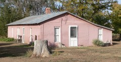 | Minor Sod House | building | 2005 | 04001428 |
 | Shirley Opera House | building | 2007 | 06001241 |
Every wildfire the federal occurrence database records inside this county: 11 of them, burning about 406 acres. 2 started naturally and none was recorded as arson. Each settlement page carries the fires within five miles of it.
| Reported cause | Fires |
|---|---|
| Missing data/not specified/undetermined | 5 |
| Debris and open burning | 3 |
| Natural | 2 |
| Equipment and vehicle use | 1 |
The five largest, by the area the report gives. None of them was recorded as arson.
| Date | Cause | Size | Reported by | Name on the report |
|---|---|---|---|---|
| 13 September 2015 | Natural | 250 acres | Kansas Forest Service | 4 |
| 15 September 2015 | Natural | 80 acres | Kansas Forest Service | 7 |
| 23 January 2016 | Debris and open burning | 60 acres | Kansas Forest Service | 01F2016 |
| 28 February 2020 | Missing data/not specified/undetermined | 6.0 acres | Kansas Forest Service | not named |
| 7 March 2020 | Missing data/not specified/undetermined | 5.0 acres | Kansas Forest Service | not named |
| 16 June 2020 | Missing data/not specified/undetermined | 2.0 acres | Kansas Forest Service | not named |
| 2 February 2020 | Missing data/not specified/undetermined | 2.0 acres | Kansas Forest Service | not named |
| 15 March 2015 | Missing data/not specified/undetermined | 1.0 acres | Kansas Forest Service | 2 |
Every settlement page carries the fires within five miles of it - see the settlement index below.
The NOAA Storm Events Database holds 844 reports for this county, causing no deaths, 6 injuries and about $2,100,930 in recorded property damage. Each settlement page carries the reports that name it.
| Kind of event | Reports |
|---|---|
| Hail | 480 |
| Thunderstorm Wind | 273 |
| Tornado | 52 |
| Flash Flood | 22 |
| Lightning | 7 |
| Flood | 5 |
| Funnel Cloud | 4 |
| Heavy Rain | 1 |
The most serious of them, by death, then injury, then recorded damage. The accounts are quoted exactly as the forecast office filed them.
| When | Event | Place named | Harm | What the report says |
|---|---|---|---|---|
| May 1951 | Tornado (F3) | not stated | 4 hurt, $2,500 | no account filed |
| June 2008 | Lightning | Atwood | 2 hurt | Three workers were shocked when their natural gas drilling rig was struck by lightning. Two workers were taken to nearby hospitals and were treated, kept overnight, and released the next morning. |
| July 2009 | Hail | Ludell | $330,000 | Siding on north side of home was heavily damaged. A bedroom window was also broken. One thousand acres of farmland suffered heavy to complete damage to crops. |
| April 2007 | Tornado (EF1) | Atwood | $305,000 | Tornado developed near Roads C, 19 and dissipated near Roads M, 22 in Rawlins county. This was a high end EF1 tornado producing significant damage to a home, removing the roof and destroying many outbuildings, grain bins and trees near Roads C, 19. Other farms were affected with outbuilding and irrigation system damage. |
| June 1984 | Tornado (F1) | not stated | $250,000 | no account filed |
| June 2014 | Thunderstorm Wind | Blakeman | $150,000 | The top half of trees were blown down. Estimated a couple hundred trees a foot in diameter or larger were blown down. Time of the event estimated from radar. |
| April 2007 | Flash Flood | Herndon | $150,000 | Torrential rainfall brought 5-6 inches of precipitation in several hours throughout the eastern half of Rawlins county, resulting in culverts and roads washed out and bridge damage in several locations. Railroad tracks just south of Herndon on Hwy 117 suffered damage, and Ash and Beaver Creeks were reported out of their banks near Herndon. |
| August 2017 | Thunderstorm Wind | Atwood | $145,000 | Fourteen power lines were broken off along CR 23 southeast of Atwood. |
| September 2007 | Thunderstorm Wind | Mc Donald | $105,000 | An intense microburst produced damage in the town of McDonald. Debris was blown mainly east to east-southeast. Four power poles were snapped resulting in power outages to McDonald and Bird City. A trailer home was blown over and destroyed. A large garage/storage building was destroyed. Numerous tree limbs down and minor roof damage occurred. |
| April 2011 | Lightning | Ludell | $100,000 | At 1330 CDT, lightning struck an oil tank battery on a farm northeast of Ludell, causing an explosion that blew the lid off the crude oil storage tank and damaged a second tank. Firefighters were able to control the fire in about an hour. |
| July 2023 | Thunderstorm Wind | Mc Donald | $50,000 | Weather Underground mesonet KKSMCDON2 reported severe thunderstorm wind gusts of 60 to 100 mph over a duration of 16 minutes in the town of McDonald. Major tree damage was reported in McDonald by law enforcement with one foot in diameter branches down. A branch went through a house, and the rest area along Highway 36 was shut down for a time due to all the branches on the ground. |
| July 2011 | Thunderstorm Wind | Herndon | $50,000 | Strong winds blew the roof off a building and lofted it over a grain bin. Grain bins also suffered roof damage. |
| April 2007 | Tornado (EF1) | Atwood | $26,000 | Tornado developed near Roads K, 27 and dissipated near Roads P, 28. Power poles were broken, with one residence receiving outbuilding and window damage. |
| July 2010 | Thunderstorm Wind | Mc Donald | $25,000 | Local electric company reported 25 poles were blown down across Cheyenne and western Rawlins counties along and north of highway 36 due to strong thunderstorm winds. |
| April 1974 | Tornado (F1) | not stated | $25,000 | no account filed |
| October 1971 | Tornado (F3) | not stated | $25,000 | no account filed |
| April 1958 | Tornado (F2) | not stated | $25,000 | no account filed |
| July 1956 | Tornado (F2) | not stated | $25,000 | no account filed |
| May 1953 | Tornado (F1) | not stated | $25,000 | no account filed |
| August 1951 | Tornado (F2) | not stated | $25,000 | no account filed |
| August 1950 | Tornado (F1) | not stated | $25,000 | no account filed |
| May 2024 | Thunderstorm Wind | Blakeman | $20,000 | Power pole was blown down by thunderstorm outflow along a cold front about seven miles west of Atwood near mile marker 47 on Highway 36. |
| May 2023 | Flash Flood | Herndon | $20,000 | At 8:35, dispatch reported multiple roads under water in Herndon. Over the following hours, conditions worsened dramatically. The town of Herndon became completely cutoff and surrounded by flood waters. These flash flood waters also put a levee upstream of the town to become at risk of failing, which would have flooded the town. Thankfully, the levee held and was able to be reinforced in the afternoon hours. North of Ludell, at least one country road culvert was completely washed out, making the road impassable. |
| May 1999 | Hail | Atwood | $20,000 | no account filed |
| June 2014 | Thunderstorm Wind | Blakeman | $15,000 | Two to three inch diameter tree limbs blown down. Estimated time of report from radar. |
| June 2001 | Thunderstorm Wind | Atwood | $15,000 | Grain Bin destroyed from winds and hail. Crops also suffered extensive damage in the area. |
| June 2014 | Thunderstorm Wind | Atwood | $12,000 | Numerous tree branches blown down in Atwood. A large tree is blocking Highway 25. Reported through Spotter Network. Estimated time of report from radar. |
| July 1997 | Thunderstorm Wind | Atwood | $12,000 | Winds estimated to at least 70 mph brought down 12 power poles. |
| July 2023 | Thunderstorm Wind | Blakeman | $10,000 | Thunderstorm winds estimated 70-80 mph caused many tree limbs to be blown down of various sizes, shingles torn off a building, and 2x4s blown out of a truck bed. |
| August 2019 | Thunderstorm Wind | Atwood | $10,000 | Thunderstorm wind damage was reported in Atwood with lots of trees down and power out in the city. |
| August 2002 | Thunderstorm Wind | Atwood | $10,000 | Power lines down. Semi overturned. |
| October 1997 | Thunderstorm Wind | Atwood | $10,000 | Gusts to 70 mph blew in or shattered windshields on 5 vehicles. The awning on the Rawlins Museum was brought down and the roof on the courthouse was damaged. At 1321CST, trees and branches were downed 2SW of Atwood. |
| June 2014 | Thunderstorm Wind | Ludell | $8,000 | Shingles were blown off the house and six inch diameter tree limbs were blown down. |
| June 2002 | Tornado (F0) | Herndon | $7,500 | Slow moving, weak tornado produced intermittent damage as it traveled north across mostly open fields before moving near the town of Herndon. Several irrigation circles were damaged and numerous trees were down and stripped of bark. |
| June 2002 | Tornado (F1) | Ludell | $6,000 | Brief touchdown near Ludell. Several power poles were down, and irrigation equipment and trailer home were damaged. |
| May 2023 | Flood | Herndon | $5,000 | In the afternoon of the 26th, the waters had stopped rising, but the town of Herndon was cutoff by all land routes until the late morning of the 27th, when all but one road became traversable. Multiple county roads were also submerged for days later, however on the 30th, flooding conditions subsided and no more roads were reported underwater, although there were many that had been washed out and destoryed. |
| August 1996 | Tornado (F1) | Herndon | $5,000 | no account filed |
| September 2017 | Thunderstorm Wind | Mc Donald | $3,000 | A power line was blown down and three six inch diameter tree limbs, along with several smaller limbs, were broken off. At the baseball field, the roof of one of the dugouts was blown off and landed about a block away. |
| July 2017 | Thunderstorm Wind | Atwood | $3,000 | Carport blown into neighbors fence, taking out 50 ft. of the fence. |
| April 2022 | Thunderstorm Wind | Blakeman | $2,500 | Strong winds associated with the outflow of a thunderstorm moving across eastern Rawlins and western Decatur counties produced estimated 70 mph winds. Small tree limbs were reported down and siding torn off a building. |
| May 2018 | Flash Flood | Herndon | $2,500 | One of the buidings in Herdon has water flowing into it. The water is four inches deep in the building. |
| June 1991 | Tornado (F0) | not stated | $2,500 | no account filed |
| May 1990 | Tornado (F0) | not stated | $2,500 | no account filed |
| June 1965 | Tornado | not stated | $2,500 | no account filed |
| July 1962 | Tornado (F1) | not stated | $2,500 | no account filed |
| May 1962 | Tornado | not stated | $2,500 | no account filed |
| July 2022 | Thunderstorm Wind | Blakeman | $2,000 | Report received of a 12 inch healthy cottonwood tree limb being blown through a metal roof of a workshop by an estimated 80 mph wind gust. Time is radar estimated and wind speed estimated from damage indicators. |
| June 2021 | Hail | Beardsley | $2,000 | Report received of siding of a mobile home destroyed due to wind driven hail. Hail was estimated to be up to a penny in size. |
| August 2019 | Thunderstorm Wind | Blakeman | $2,000 | A sixteen inch diameter tree was reportedly blown down and a door jam on the outside door of a house was broken from the winds. |
| August 2019 | Thunderstorm Wind | Blakeman | $2,000 | Fourteen inch green Cottonwood tree limbs down. |
| June 2008 | Hail | Atwood | $1,500 | Hail broke the mirror and resulted in dents to a vehicle. |
| June 2002 | Thunderstorm Wind | Herndon | $1,500 | Several power poles down. |
| June 2013 | Thunderstorm Wind | Atwood | $1,100 | Strong thunderstorm winds damaged a latched storm door, broke a 4 x 8 foot glass window and snapped some two-inch diameter live tree limbs. |
| June 2025 | Thunderstorm Wind | Blakeman | $1,000 | Spotter estimated 70 to 80 mph winds with blowing dust creating visibility reductions of 1/8 to 1/2 half mile. Also reported a 12 inch and multiple 8 inch tree limb broken. Some 8 inch limbs were thrown 300 to 350 feet from trees. |
| May 2019 | Lightning | Achilles | $1,000 | Lightning struck an oil battery in eastern Rawlins County. |
| July 2019 | Lightning | Atwood | $1,000 | Lightning damage was reported from a thunderstorm in Atwood. The report was received via Facebook message with a picture showing minor damage to a brick chimney with a few bricks damaged. |
| May 2018 | Thunderstorm Wind | Blakeman | $1,000 | Fourteen inch diameter ash tree blown down from thunderstorm winds. A camper was also lifted a foot off the ground. |
| June 2015 | Thunderstorm Wind | Blakeman | $1,000 | A 100 year old tree was blown down. |
| April 2011 | Lightning | Atwood | $1,000 | At 1150 CDT, lightning struck next to the golf cart stalls at the Atwood Country Club. One golf cart, and three cart stalls, were damaged. |
| July 2011 | Lightning | Beardsley | $1,000 | Lightning strike started a bale fire overnight, resulting in response of two fire departments. |
Named settlements recorded in the Geographic Names Information System, each with the topographic sheets covering it. Villages, hamlets and abandoned places alike. Each is shown with the nearest named watercourse or landform and the survey quadrangle it falls on.
Atwood township · 67730 · On Little Beaver Creek · Atwood quadrangle
9 sheets, 1951 to 1985