 Block
From the record
9 National Register listings published here.
Sources: the county history on the Internet Archive · the National Register database, National Park Service
30 topographic sheets cover 15 settlements here, and 9 properties are on the National Register of Historic Places.
9 National Register listings published here.
Sources: the county history on the Internet Archive · the National Register database, National Park Service
Every property in this county listed on the National Register of Historic Places, with the year it was listed and the federal nomination document.
| Photograph | Property | Type | Listed | Reference |
|---|---|---|---|---|
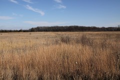 | Birch Coulee | site | 1973 | 73000995 |
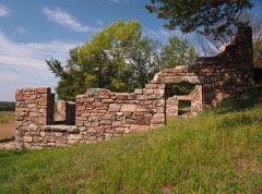 | Joseph Brown House Ruins | site | 1986 | 86002838 |
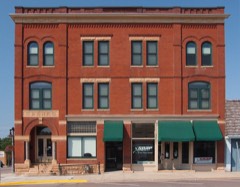 | Heins Block | building | 2001 | 01000842 |
| Hotel Sacred Heart | building | 2016 | 16000279 | |
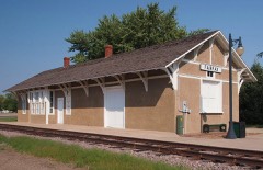 | Minneapolis and St. Louis Depot | building | 1986 | 86001921 |
 | Renville County Courthouse and Jail | building | 1986 | 86001281 |
| Lars Rudi House | building | 1986 | 86001924 | |
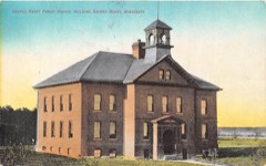 | Sacred Heart Public School | building | 2014 | 14000869 |
| Tinnes-Baker House | building | 2021 | 100006437 |
Every wildfire the federal occurrence database records inside this county: 6 of them, burning about 254 acres. None started naturally and 2 were recorded as arson. Each settlement page carries the fires within five miles of it.
| Reported cause | Fires |
|---|---|
| Missing data/not specified/undetermined | 3 |
| Arson/incendiarism | 2 |
| Equipment and vehicle use | 1 |
The five largest, by the area the report gives. Two of them were set deliberately.
| Date | Cause | Size | Reported by | Name on the report |
|---|---|---|---|---|
| 19 July 2014 | Arson/incendiarism | 108 acres | Litchfield Wetland Management District | TEACHERS WF |
| 19 March 2017 | Missing data/not specified/undetermined | 48 acres | Litchfield Wetland Management District | CREAM CITY WF |
| 7 April 2004 | Missing data/not specified/undetermined | 40 acres | Minnesota Department of Natural Resources | not named |
| 18 April 2015 | Missing data/not specified/undetermined | 40 acres | Litchfield Wetland Management District | BROOKFIELD WF |
| 30 October 2006 | Equipment and vehicle use | 17 acres | Litchfield Wetland Management District | SACRED HEART FIRE |
| 6 July 2014 | Arson/incendiarism | 1.0 acres | Minnesota Department of Natural Resources | not named |
Every settlement page carries the fires within five miles of it - see the settlement index below.
The NOAA Storm Events Database holds 427 reports for this county, causing 1 death, 6 injuries and about $27,740,500 in recorded property damage. Each settlement page carries the reports that name it.
| Kind of event | Reports |
|---|---|
| Hail | 186 |
| Thunderstorm Wind | 163 |
| Tornado | 30 |
| Heavy Rain | 19 |
| Flash Flood | 13 |
| Funnel Cloud | 9 |
| Flood | 6 |
| Lightning | 1 |
The most serious of them, by death, then injury, then recorded damage. The accounts are quoted exactly as the forecast office filed them.
| When | Event | Place named | Harm | What the report says |
|---|---|---|---|---|
| July 2018 | Flood | Franklin | 1 killed, $375,000 | Flood waters slowly receded from excessive rainfall that occurred Tuesday morning. Numerous roads were impacted by the flood waters, especially south of Highway 212. An individual was found in a water-swollen drainage ditch, two days after his car was discovered submerged a mile upstream. |
| June 2003 | Tornado (F2) | Buffalo Lake | 5 hurt, $14,000,000 | This third tornado entered Renville County at 1845 CST and entered the city of Buffalo Lake, where damage was significant. Five people sustained minor injuries. Roofs were blown off the Lutheran Church, as well as a number of homes and businesses. Sheds and garages were blown down, a grain elevator was destroyed, and hundreds of trees were broken. Video and a storm survey determined the tornado was multiple vortex. 29 houses were damaged beyond repair, 51 sustained major damage, and 120 more suffered minor damage. |
| June 2003 | Thunderstorm Wind | Bird Island | 1 hurt | A children's playhouse was lifted and blown some distance, where it landed on a truck being driven along Highway 212. One man was slightly injured when some of the smashed glass landed in his eye. |
| June 2003 | Thunderstorm Wind | Churchill | $6,000,000 | A wide swath of wind originated in Kandiyohi County and swept across Meeker, Renville and McLeod Counties. Numerous trees were downed, sheds and outbuildings blown over, several barns were flattened, and grain bins blown over. About 50 farmsteads were damaged across an approximate area of 30 to 40 square miles. |
| July 2011 | Thunderstorm Wind | Bechyn | $1,000,000 | A long-lived and complex storm moved into western Renville County around 346 PM CST, and caused considerable damage to outbuildings, a few homes, crops and trees across a wide area of the county. Based on the damage reports and radar imagery, wind speeds were likely sustained above 70 to 90 mph, for 10 to 15 minutes in any given location as the storm traversed the county. Crop damage has been estimated at nearly 20,000 acres destroyed in Renville County alone. |
| June 1998 | Tornado (F1) | Olivia | $1,000,000 | Construction company building and recycling center destroyed. Department of Transportation building damaged. Vehicles damaged at dealership. |
| June 2014 | Flood | Fairfax | $750,000 | Several county roads and highways were damaged due to flood waters, especially along the Minnesota River Valley area. |
| July 2016 | Lightning | Sacred Heart | $500,000 | A lightning bolt struck a church in Sacred Heart, Minnesota. The lightning started a fire and destroyed the church which was built 140 years before. No one was injured, but the church was a total loss. |
| June 2003 | Tornado (F1) | Buffalo Lake | $500,000 | This fourth tornado entered Renville County at 1912 CST and hit portions of one farmstead. Sheds, outbuildings and grain bins were damaged, a barn was flattened, and a number of trees were downed. The tornado dissipated before it reached Highway 212. |
| June 2003 | Tornado (F1) | Buffalo Lake | $500,000 | The first of five tornadoes to hit the Buffalo Lake area this evening, the tornado hit three farmsteads before crossing into Sibley County at 1755 CST. Trees were knocked down, sheds and outbuildings destroyed, a grain dryer was overturned, a grain bin and silo were destroyed, and houses sustained minor damage. |
| March 2010 | Flood | Bechyn | $335,000 | County Road 21, near the Minnesota River was closed due to flooding. There was also an ice jam east of this area where several county roads closed. Monetary costs were based on FEMA, State, and Local assistance which includes the following categories; debris removal, emergency protective measures, road systems and bridges, and water control facilities. |
| August 2017 | Flash Flood | Morton | $325,000 | Very heavy rainfall, and associated flooding, led to temporarily closures of Anderson Lake County Park in Franklin, along with Beaver Falls and Birth Coulee County Parks in Morton. Mack Lake County Park in Fairfax, Skalbekken County Park in Sacred Heart and Vicksburg Park in Renville were also closed due to the flooding. Several county roads in southwest Renville County were closed, and some became impassable. |
| April 2023 | Flood | Minnesota Falls | $284,000 | A combination of record setting seasonal snowfall, high snow water equivalent values, and rapid snow melt led to low lying areas, ditches and ravines across the county to flood for a prolonged period of time. Road infrastructure such as bridges, gravel roads, and culverts experience varied degrees of damage caused by rapid runoff. Renville County Emergency Management reported that $284,300 in damages to roads and bridges. |
| July 2018 | Flash Flood | Bechyn | $250,000 | Several rounds of very heavy rainfall caused flash flooding to occur in Renville county. The worst areas were in the southern and central 1/3 of the county. Over 50 township and county roads affected. The most concentrated area was south of Highway 4, between County Road 6 and U.S. Highway 71. |
| July 2011 | Tornado (EF1) | Danube | $250,000 | An EF-1 tornado touched down north-northwest of Danube, and moved north-northeast. It dissipated approximately 3.7 miles north of Danube and caused damage to a house and a large equipment shed along its path. |
| August 1981 | Tornado (F2) | not stated | $250,000 | no account filed |
| June 1981 | Tornado (F2) | not stated | $250,000 | no account filed |
| July 2019 | Flash Flood | Morton | $200,000 | There was an unconfirmed report of 7 inches of rainfall around the Morton area. There were also measured rainfall amounts of 3 to 6 inches around the area. Due to the extreme rainfall amounts, and the impact of the area, approximately 30 homes were flooded from local small streams and runoff. Three homes had 6-8 feet of water in their basements, and Minnesota Highway 19 was closed east of Morton due to a mudslide. |
| April 2001 | Flash Flood | Countywide | $200,000 | no account filed |
| May 2004 | Flash Flood | Countywide | $120,000 | no account filed |
| August 2023 | Hail | Lakeside | $100,000 | Baseball size hail hit the Oakdale golf course, denting cars, shattering windows, and causing hundreds of pits in the greens. |
| May 2022 | Thunderstorm Wind | Buffalo Lake | $100,000 | A barn, grain bin, and multiple trees were blown down southwest of Buffalo Lake in Renville County. There was also sporadic tree damage from southwest of Buffalo Lake, to the northeast of the city. |
| August 2020 | Thunderstorm Wind | Minnesota Falls | $100,000 | Numerous reports of downed trees and power lines from the eastern part of Granite Falls, eastward along Highway 212 to Sacred Heart. However, the damage became more sporadic eastward toward Sacred Heart. |
| June 2013 | Thunderstorm Wind | Bird Island | $100,000 | A Bird Island grain elevator sustained damage, along with several trees blown down around Bird Island. |
| July 2022 | Thunderstorm Wind | Renville | $75,000 | Numerous trees and power lines were blown down between Renville and Olivia. Some trees fell on cars, houses, and sheds. |
| August 2021 | Thunderstorm Wind | Sacred Heart | $50,000 | Damage occurred north of Sacred Heart, and south of County Road 11. There was a metal roof that was blown several feet from its foundation and had its roof peeled off. Plus, several large trees were blown down. In addition, the farm had some of their corn flattened. |
| May 2022 | Thunderstorm Wind | Renville | $25,000 | Several homes had roof damage and a few large trees were uprooted north of Renville. |
| May 2022 | Thunderstorm Wind | Sacred Heart | $25,000 | Severe straight-line winds blew down a large grain bin near Sacred Heart and blocked part of Highway 212. |
| June 2019 | Thunderstorm Wind | Olivia | $25,000 | There were numerous power lines that were damaged, 3 were snapped, and several large tree limbs, up to 10 inches in diameter, were blown down from near Olivia, to Hector. |
| May 2023 | Tornado (EF0) | Minnesota Falls | $15,000 | Video shows a tornado moving mainly east, and then lifting north/northeast across far western Renville county. There was minor damage to an outbuilding. The tornado was rated EF0 based on the damage in the video. |
| July 2011 | Tornado (EF1) | Bechyn | $15,000 | An EF-1 tornado continued along a path across western Renville County, and moved approximately 1.5 miles before dissipating near the intersection of 740th Avenue and 240th Street. Several trees were uprooted as it moved into Renville County. Total path length through Redwood, Yellow Medicine and Renville Counties was 19.75 miles. |
| August 2020 | Thunderstorm Wind | Sacred Heart | $5,000 | A few large trees were blown down between Sacred Heart, and Renville, including a large tree that fell on a house in Renville. |
| June 2019 | Thunderstorm Wind | Lakeside | $5,000 | A large farm north of Buffalo Lake, Minnesota, received significant damage to their grain bins. Also, several large branches were blown down, with six power poles damaged near the area. |
| September 2010 | Thunderstorm Wind | Olivia | $5,000 | Severe thunderstorm winds caused a railroad crossing arm at Highway 71, and 212 to bend in half. |
| October 1963 | Tornado (F1) | not stated | $2,500 | no account filed |
| August 2016 | Thunderstorm Wind | Bird Island | $2,000 | Several trees and large tree branches were blown down in Bird Island. One of the branches landed on a home and damaged it. |
| August 2022 | Thunderstorm Wind | Olivia Muni Arpt | $1,500 | Numerous large trees were blown down around Olivia, and a large billboard side was knocked over. |
| May 1978 | Tornado (F0) | not stated | $250 | no account filed |
| June 1967 | Tornado (F0) | not stated | $250 | no account filed |
| June 2025 | Thunderstorm Wind | Olivia Muni Arpt | - | Thunderstorm winds estimated at 65 mph downed a few trees and flipped over a semi on HWY 71 just north of Olivia, MN. |
| June 2025 | Hail | Olivia | - | Half dollar sized hail near CR11 north of Olivia. |
| June 2025 | Hail | Bechyn | - | Lots of nickel to quarter size hail north of Morton. |
| June 2025 | Thunderstorm Wind | Bird Island | - | Thunderstorm winds downed powerlines on Hwy 5 south of Bird Island. |
| August 2025 | Thunderstorm Wind | Morton | - | Dispatch reported a large tree down blocking the road just northwest of Morton. |
| August 2025 | Thunderstorm Wind | Bechyn | - | County dispatch reported a large tree down blocking the road. This was a delayed report, with time being estimated from radar. |
| June 2025 | Flash Flood | Minnesota Falls | - | Report of damage to several roads in Wang and Hawk Creek Townships, including one road closure. Many roads within the city of Renville reported standing water and basements quickly flooded with one reported over 5 feet deep. Emergency pumping operations were conducted in the city of Renville due to the flooding. |
| June 2025 | Thunderstorm Wind | Renville | - | Storm chaser reported numerous trees down in Renville. |
| July 2024 | Thunderstorm Wind | Bird Island | - | Trees were down in Melville Township, near the intersection of Co Rd 3/Hwy 212. |
| July 2024 | Thunderstorm Wind | Bird Island | - | A power pole was snapped. |
| July 2024 | Thunderstorm Wind | Olivia | - | Several trees and large branches were down. |
| July 2024 | Thunderstorm Wind | Olivia Muni Arpt | - | Railroad crossing arms on the north side of the airport were damaged. |
| July 2024 | Thunderstorm Wind | Olivia | - | Trees were down. |
| September 2024 | Hail | Renville | - | Report from Mping. |
| September 2024 | Hail | Danube | - | Lots of different sized hail was reported, up to golf ball. |
| June 2024 | Tornado (EF0) | Sacred Heart | - | A storm chaser filmed a brief tornado. It broke a few large branches before moving into an open field and dissipating. |
| June 2024 | Hail | Sacred Heart | - | Photos were sent to the NWS. |
| May 2023 | Tornado (EFU) | Renville | - | At 1831 CST storm chaser video confirmed a weak tornado developed near 260th St in Renville County. This storm continued into Kandiyohi county towards the city of Prinsburg, MN. No injuries or damages were reported. |
| May 2023 | Tornado (EFU) | Renville | - | At 1818 CST storm chaser video confirmed a weak tornado developed southeast of 20699 860th Street. No injuries or damages were reported. |
| August 2023 | Hail | Lakeside | - | Pictures on social media showed hail up to the size of baseballs north of Buffalo Lake near Lake Allie. |
| May 2022 | Thunderstorm Wind | Olivia | - | Several trees were blown down in Olivia. |
The Survey's mineral resources record lists 10 workings inside this county. 9 still produce and 1 is closed or unrecorded. Each settlement page carries the workings within five miles of it.
| Commodity | Workings |
|---|---|
| Sand and Gravel, Construction | 7 |
| Stone, Crushed/Broken | 1 |
| Aluminum, Iron, Silica, Titanium, Water, Free | 1 |
| Granite | 1 |
The least common of them first, because a county's hundredth gravel pit says nothing its first ten did not.
| Where | Site | Commodity | Status | Recorded |
|---|---|---|---|---|
| Minnesota River Valley Clays | Aluminum, Iron, Silica, Titanium, Water, Free | Occurrence | ||
| Rainbow Quarry | Stone, Crushed/Broken | Producer | ||
| Rainbow Quarry | Granite | Producer | ||
| Bartel Pit and Mill | Sand and Gravel, Construction | Producer | ||
| Danube Sand and Gravel Pit | Sand and Gravel, Construction | Producer | ||
| Duninck Bros Pit | Sand and Gravel, Construction | Producer | ||
| Hagen Pit | Sand and Gravel, Construction | Producer | ||
| Heil Pit | Sand and Gravel, Construction | Producer | ||
| Marlowe Pit | Sand and Gravel, Construction | Producer | ||
| Serbus Mill | Sand and Gravel, Construction | Producer |
The History of Renville County, Minnesota devotes a chapter to each township: its boundaries and streams, who settled it and when, the mills, the schools and the churches. All 9 are reproduced here in full. Each row shows the township's own shape and where it lies in the county, drawn from the Census Bureau's boundary. Which settlements belong to which township is computed from that same boundary, not taken from the book.
| Shape and position in the county | Township | Settlements in it | Length | Sections |
|---|---|---|---|---|
| Beaver Falls Township | Beaver Falls | 1,361 words | 0 | |
| Birch Cooley Township | Franklin | 1,344 words | 0 | |
| Bird Island Township | Bird Island | 8,051 words | 0 | |
| Boon Lake Township | Lakeside | 7,254 words | 0 | |
| Brookfield Township | Churchill | 726 words | 0 | |
| Emmet Township | Renville | 7,514 words | 0 | |
| Hector City | Hector | 1,945 words | 0 | |
| Henryville Township | Bechyn | 4,677 words | 0 | |
| Sacred Heart City | Sacred Heart | 9,233 words | 0 |
One book written about this county, cut here where the book itself is cut, at its printed chapters: 18 chapters in all. Every chapter is public domain, machine-read from the scan and reproduced complete. A chapter already given under one of the county's towns is not repeated in this list.
| Chapter | Length |
|---|---|
| Chapter with an unread heading (no. 1 of those read) | 20,881 words in 2 parts |
| Chapter 30: Physicians and Surgeons | 9,102 words |
| Chapter 31: Rural Schools | 7,772 words |
| Chapter 32: Swine Industry in Renville County | 9,490 words |
| Chapter 33: Agricultural Development | 9,680 words |
| Chapter 34: Dairying and Creameries | 5,486 words |
| Chapter 35: Good Roads | 1,851 words |
| Chapter 36: Cities and Villages | 36,186 words in 3 parts |
| Chapter 37: Experiences During Outbreak | 7,738 words |
| Biographical sketches (1 of 2 so headed) | 153,249 words in 10 parts |
| Bench and Bar | 6,247 words |
| Biographical sketches (2 of 2 so headed) | 6,184 words |
| Chapter 40: Renville County Churches | 29,635 words in 2 parts |
| Chapter 42: Pioneer Association | 2,074 words |
| Chapter 43: Monuments and Markers | 6,492 words |
| Chapter 44: Stories of Olden Days | 9,183 words |
| Chapter with an unread heading (no. 16 of those read) | 7,831 words |
| Newspapers | 7,794 words |
Named settlements recorded in the Geographic Names Information System, each with the topographic sheets covering it. Villages, hamlets and abandoned places alike. Each is shown with the nearest named watercourse or landform and the survey quadrangle it falls on.