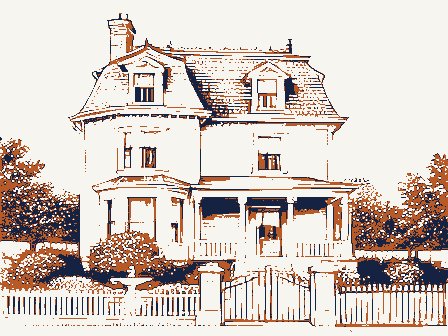
Listed on the National Register of Historic Places in
2003. A historic map-sheet match is not published yet. The record needs a coordinate-quality review before it can be joined to a sheet boundary.
From the record
“The first sermon heard in Parma was delivered in 1823, at the house of Asa Emerson, by Rev. Henry Iludson, of Royalton, a Baptist minister.”
History of Cuyahoga County Ohio (1870). Machine-read text.
one of 338 National Register listings in Cuyahoga County · listed in 2003 · category: Building · one of 3 National Historic Landmarks in Cuyahoga County.
National Register reference number.03000859- the number the National Park Service assigned this property when it was listed, and the key its nomination file is catalogued under at the National Archives.
What happened here
An account from the chapter on Parma city, The inset identifies its exact
source book and publication year.
The first graveyard laid out by white settlers in Rockport occupied the site of the Cliff House. Here, it.is said, were buried the bodies of a number of sailors drowned off the "point" in 1812. Henry Alger was buried there as was also Daniel Miner, two of the pioneers, but their bodies were afterward removed elsewhere.
The chapter on Parma City in History of Cuyahoga County Ohio, published 1870 names Parma. This is what it says, exactly as the scans read.
Parma, one of the youngest townships in Cuyahoga, covers an area of five miles square, being the territory of survey-township six, in range thirteen. Brooklyn township lies on the north, Royalton on the south, Independence on the east, and Middleburg on the west. Of the population of fifteen hundred, reported by the last census, full two-thirds are estimated to be Germans and other foreigners - the former largely predominating, and manifesting their usual energy as thrifty, industrious husbandmen. They concentrate in settlements, have churches of their own, and, although somewhat clannish, are liberally represented in the administration of public affairs.
Parma has no streams of any consequence, nor has it any railway communication within its own lmits, although that convenience is near at hand. It contains a strictly agricultural community, and has no village within its borders. Nevertheless, its schools are excellent, its churches are plentiful, and the people generally appear to be in a prosperous condition.
Regional context, not property-specific
evidence. The
federal wildfire occurrence database
lists 3 fires within 5 miles of Henninger, Phillip, House between
1993 and 2018, burning about 8 acres in total. 1 started naturally. 1 was recorded as arson.
Distance is straight-line from the map coordinates, so a fire counted
here may appear on a neighbouring settlement's page as well.
Reported cause
Fires
Arson/incendiarism
1
Missing data/not specified/undetermined
1
Natural
1
The most recent of
them, most recent first, with the day each was reported and the service
that recorded it.
Regional context, not property-specific
evidence. Museums hold 3,541 specimens
collected within 10 miles of Henninger, Phillip, House between 1849 and
1975: 3,103 Animalia, 211 Fungi, 147 Plantae, 73 Protozoa, 5 Unrecorded, 1 Chromista, 1 incertae sedis. 12 distinct Species records are shown.
Collected by A. D. Huryn, A. D. Selby, A. G. Newhall and others. Each is a
physical object with a catalogue
number, and each entry opens the museum's record. This is what was
collected and kept, not a survey of what lives here - nothing can be
concluded from a species being absent.
Regional context, not property-specific
evidence. The federal mineral resources record lists
19 workings within 5 miles of Henninger, Phillip, House: 8 producers, 5 past producers, 5 unknowns, 1 plant.
9 still produce. What was taken out: Clay, Iron, Sand and Gravel, Construction, Bloating Material. Distance is straight-line from the
map coordinates, so a quarry counted here may appear on a neighbouring
settlement's page as well.
Regional context, not property-specific
evidence. The National Weather Service names
Parma, the town this property stands in, in 31 storm reports between 1994 and 2026: 17 thunderstorm wind, 13 hail, 1 flash flood.
No death or injury is recorded in these reports. Each account below is quoted exactly as the forecast office
filed it, from the NOAA Storm Events Database, and each date
opens the federal record of that event.
During the early afternoon of July 5 thunderstorms with torrential rain fell across portions of Cuyahoga County. Radar estimates put storm total rain amounts between 2.5 and 3 inches in the City of Parma. However the public reported a measurement near Ridge and Pleasant Valley Road of 4.12 inches. Another nearby rain gage supports this estimate with a measurement of 2.6 inches during the storm. Rainfall rates averaged 2 inches an hour during this event, peaking around 256 PM with rates estimated 4 to 6 inches an hour for approximately 15 minutes dropping over an inch of rain. A storm spotter in North Royalton reported 2 inches in 30 minutes around 230 PM. Flooding started to effect low lying and poor drainage areas around 230 PM, but the increase in intensity near the top of the hour resulted in rapid flash flooding. By 315 PM some water was inundating homes in North Royalton, mainly in basements. In Parma, the majority of heavy rainfall was in the southwest corner of the City, South of Pleasant Valley Road. The flooding was mostly concentrated along Big Creek headwaters with extensive damage to homes and businesses. At least two homes on Stormes Drive foundations gave way and are no longer inhabitable. Other homes were inundated in their first floor by 2 to 3 feet of water on Stormes Drive. Its estimated that in Parma alone, more than 1000 homes and businesses were flooded, primarily in the area located south of Ridgewood Drive to Sprague Road, as well as between State Road and West 130th Street, several of which had never experienced flooding before. A nursing home near Pleasant Valley Road and Ridge Road sustained over 6 million dollars in damages with nearly 100 residents displaced and 17 cars in the parking lot totaled. Parking lot and garage of University Hospital flooded and resulted in several cars damaged or destroyed.
Thunderstorms produced downburst winds that downed numerous large tree limbs. At least one utility pole was downed, along with several power lines. A three season porch was destroyed by the downburst winds.
No historic map-sheet match is published
for this property yet. That does not mean no map exists. This record needs
a coordinate-quality review before it can be joined to a sheet boundary.
Browse the county's mapped places while that work is
pending.
From the nomination file
8,636 words on record
When this property was proposed for the
National Register, someone wrote the case for it: what the building is,
and why it matters. That document is a federal record in the public domain.
It is quoted below word for word, never summarised. The text was read off the scanned case file by machine, so the
occasional stray character is the recogniser's and the 1970s
typewriter's.
Statement of significance
Applicable National Register Criteria Areas of Significance Enter categories from instructions for National Register listing) X A Property is associated with events that have made a significant contribution to the broad patterns of significant in our past. X C Property embodies the distinctive characteristics of a type, period,or method of construction or represents the work of a master, or possesses high artistic values, or represents a significant and distinguishable entity whose components Period of Significance lack individual distinction. -D Property has yielded, or is likely to yield information important in prehistory or history.
Criteria Considerations Significant Dates (Mark "X" in all the boxes that apply.) 1842, 1849, 1901 LA owned by a religious institution or used for Significant Person ] B removed from its original location. (Complete if Criterion B is marked above) - C a birthplace or a grave. -D a cemetery. Cultural Affiliation -E a reconstructed building, object,or structure. - F a commemorative property. -G less than 50 years of age or achieved significance within the past 50 years. Narrative Statement of Significance (Explain the significance of the property on one or more continuation sheets.) 9.
Quoted from the National Register nomination
for reference 03000859, 90 pages, held by the National Archives in Record
Group 79. See the
catalogue record.
Listed places nearby
6 within 8 miles
Other National Register properties close
enough to walk or drive between, ordered by distance from this one. Both
positions come from the same geocoding pass that matched these properties
to their map sheets.
Listing record. National Park Service National Register of Historic Places, listed-properties dataset, current to 2026-05-22.
Map join. Address geocoded through the United States Census geocoder, then tested against the published boundary of every sheet in the USGS Historical Topographic Map Collection.
How this page is made. Listing fields come from federal records; map-sheet coverage is a labelled coordinate-to-boundary calculation, not a source-field claim.
Wildfire. Short, Karen C. 2022. Spatial wildfire occurrence data for the United States, 1992-2020 [FPA_FOD_20221014]. 6th Edition. Fort Collins, CO: Forest Service Research Data Archive. https://doi.org/10.2737/RDS-2013-0009.6 Collected with United States Government funding and usable without additional permissions or fees.
Specimens. Global Biodiversity Information Facility (GBIF), https://www.gbif.org/. Only records licensed CC0 or CC BY are used. Records licensed CC BY-NC are excluded because this site carries advertising. Images are checked individually and any whose licence is non-commercial, no-derivatives or unreadable is refused.
Mines and quarries. USGS Mineral Resources Data System (MRDS) https://mrdata.usgs.gov/mrds/ A work of the United States government, no copyright under 17 U.S.C. 105.
Storms. NOAA National Centers for Environmental Information, Storm Events Database https://www.ncei.noaa.gov/stormevents/ A work of the United States government, no copyright under 17 U.S.C. 105. Narratives are quoted verbatim from the National Weather Service report and are not edited or summarised.
 Block
Block