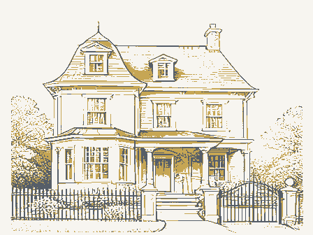
Listed on the National Register of Historic Places in
1974. A historic map-sheet match is not published yet. The record needs a coordinate-quality review before it can be joined to a sheet boundary.
From the record
one of 338 National Register listings in Cuyahoga County · listed in 1974 · category: Building · one of 3 National Historic Landmarks in Cuyahoga County.
National Register reference number.74001458- the number the National Park Service assigned this property when it was listed, and the key its nomination file is catalogued under at the National Archives.
Fires near this property
3 since 1993
Regional context, not property-specific
evidence. The
federal wildfire occurrence database
lists 3 fires within 5 miles of Kuenzer, Joseph II, House between
1993 and 2018, burning about 8 acres in total. 1 started naturally. 1 was recorded as arson.
Distance is straight-line from the map coordinates, so a fire counted
here may appear on a neighbouring settlement's page as well.
Reported cause
Fires
Arson/incendiarism
1
Missing data/not specified/undetermined
1
Natural
1
The most recent of
them, most recent first, with the day each was reported and the service
that recorded it.
Regional context, not property-specific
evidence. Museums hold 3,383 specimens
collected within 10 miles of Kuenzer, Joseph II, House between 1849 and
1975: 2,951 Animalia, 210 Fungi, 142 Plantae, 73 Protozoa, 5 Unrecorded, 1 Chromista, 1 incertae sedis. 12 distinct Species records are shown.
Collected by A. D. Huryn, A. D. Selby, A. G. Newhall and others. Each is a
physical object with a catalogue
number, and each entry opens the museum's record. This is what was
collected and kept, not a survey of what lives here - nothing can be
concluded from a species being absent.
Regional context, not property-specific
evidence. The federal mineral resources record lists
10 workings within 5 miles of Kuenzer, Joseph II, House: 5 producers, 5 past producers.
5 still produce. What was taken out: Clay, Sand and Gravel, Construction, Bloating Material, Limestone, General. Distance is straight-line from the
map coordinates, so a quarry counted here may appear on a neighbouring
settlement's page as well.
Regional context, not property-specific
evidence. The National Weather Service names
Independence, the town this property stands in, in 6 storm reports between 1996 and 2017: 3 thunderstorm wind, 2 hail, 1 flood.
No death or injury is recorded in these reports. Each account below is quoted exactly as the forecast office
filed it, from the NOAA Storm Events Database, and each date
opens the federal record of that event.
Runoff from heavy rains on January 5th caused the Cuyahoga River at Independence to quickly rise. The river went above the flood stage of 16 feet during the evening hours of the 5th. The river crested at 20.64 feet around 4 a.m on the 6th and went back below flood stage during the late afternoon hours of the 6th. Significant flooding occurred in the Valley View area. Many homes and businesses along Canal Road and Gleeson, Charles, Frances and Stone Streets were damaged by flooding.
No historic map-sheet match is published
for this property yet. That does not mean no map exists. This record needs
a coordinate-quality review before it can be joined to a sheet boundary.
Browse the county's mapped places while that work is
pending.
From the nomination file
2,131 words on record
When this property was proposed for the
National Register, someone wrote the case for it: what the building is,
and why it matters. That document is a federal record in the public domain.
It is quoted below word for word, never summarised. The text was read off the scanned case file by machine, so the
occasional stray character is the recogniser's and the 1970s
typewriter's.
Description of the property
cellar, approximately 12 by 25 feet, with a stone barrel-vaulted MAR 2 1 1974 NATION CONDITION a kitchen porch, and full two-story projecting window bays with DESCRIPTION REGIS overhanging gables. The porches, gables and over-windows have the The interior has seventeen rooms. The plan is unsymmetrical, have been rearranged by the present owner, an architect. The kitchen gouge and lathe. The porch roof on the west side is supported by the house. the Eastlake furniture style which includes circular knobs and reeded The general impression of the exterior is the irregularity common duplicated. vaulted cellar is probably the most significantly unusual part of constituting a historic district. This is a large two-story frame house in the Eastlake Style.
As an isolated country house, this building has no neighbors neath the kitchen and part of an outside porch, there is a storage area and the cellar stairs have also been remodeled.These altera- In the basement, the joists are partly supported by cast-iron which has been largely preserved and restored. tions do not detract from the essential character of the l880's interior, to the domestic styles of the 1880's.There is a small front stoop, posts with long curved brackets.The porch has been extended to the with a free flow of space made possible by sliding doors.The rooms Good (Check One) Fair Several steps lower, under- columns, with Egyptianesque capitals. fluting.The hall and bedroom access at the top of the front stairs Victorian taste.
This oaken woodwork again displays borrowing from ceiling. It is completely below grade level. This stone-built and are spacious if somewhat heavy in ornamental woodwork in the distinctive type of furniture-derived ornament produced by the chisel, RECEIVED PERIOD (Check One or More as Appropriate) - Pre-Columbian!
This house was the product of a generation of production and Ohio,he bought a large farm and the adjacent rock strata south especially the vaulted cellar are excellent tangible evidence of the production and technique of this essential Invention AREAS OF SIGNIFICANCE (Check One or More as Appropriate) Art ation blocks, porch and entry stones, lintels and so on. Kuenzer's Cuyahoga County, "The chief industry of Independence is the quarry- he had learned the stonecutter's trade near Mannheim. On arriving and the next year began using steam-driven machinery for turning In 1862 Kuenzer obtained a patent for removing the dust generated by the stone lathe. In 1867 Joseph, Jr., succeeded to the business, present house was built in l883 by Joseph II.
The foundations and invention in the important stone quarries of Independence Township, The builder's father was Joseph Kuenzer (also spelled Kinzer), buildings and structures throughout the Western Reserve for found- of the present Rockside Road. According to Johnson's history of a few hand-cut grindstones, but was soon employing many
Quoted from the National Register nomination
for reference 74001458, 14 pages, held by the National Archives in Record
Group 79. See the
catalogue record.
Listed places nearby
6 within 8 miles
Other National Register properties close
enough to walk or drive between, ordered by distance from this one. Both
positions come from the same geocoding pass that matched these properties
to their map sheets.
Listing record. National Park Service National Register of Historic Places, listed-properties dataset, current to 2026-05-22.
Map join. Address geocoded through the United States Census geocoder, then tested against the published boundary of every sheet in the USGS Historical Topographic Map Collection.
How this page is made. Listing fields come from federal records; map-sheet coverage is a labelled coordinate-to-boundary calculation, not a source-field claim.
Wildfire. Short, Karen C. 2022. Spatial wildfire occurrence data for the United States, 1992-2020 [FPA_FOD_20221014]. 6th Edition. Fort Collins, CO: Forest Service Research Data Archive. https://doi.org/10.2737/RDS-2013-0009.6 Collected with United States Government funding and usable without additional permissions or fees.
Specimens. Global Biodiversity Information Facility (GBIF), https://www.gbif.org/. Only records licensed CC0 or CC BY are used. Records licensed CC BY-NC are excluded because this site carries advertising. Images are checked individually and any whose licence is non-commercial, no-derivatives or unreadable is refused.
Mines and quarries. USGS Mineral Resources Data System (MRDS) https://mrdata.usgs.gov/mrds/ A work of the United States government, no copyright under 17 U.S.C. 105.
Storms. NOAA National Centers for Environmental Information, Storm Events Database https://www.ncei.noaa.gov/stormevents/ A work of the United States government, no copyright under 17 U.S.C. 105. Narratives are quoted verbatim from the National Weather Service report and are not edited or summarised.
 Block
Block