Listed on the National Register of Historic Places in
1976. A historic map-sheet match is not published yet. The record needs a coordinate-quality review before it can be joined to a sheet boundary.
From the record
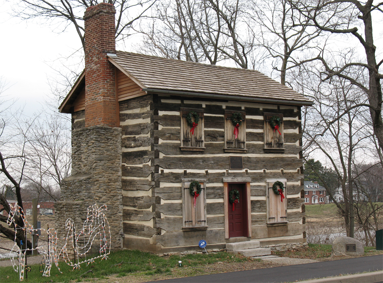
“The Old Log Post Office, also known as the Franklin Post Office is an historic building located in Franklin, Ohio. Built in 1802, the two-story log cabin is the oldest surviving post office in the state and the oldest building in Franklin.”
Wikipedia article Franklin Post Office, CC BY-SA 4.0.
one of 30 National Register listings in Warren County · listed in 1976 · category: Building.
National Register reference number.76001541- the number the National Park Service assigned this property when it was listed, and the key its nomination file is catalogued under at the National Archives.
Regional context, not property-specific
evidence. Museums hold 114 specimens
collected within 10 miles of Old Log Post Office between 1888 and
1975: 106 Animalia, 6 Plantae, 2 Fungi. 12 distinct Species records are shown.
Collected by A Schwartz, A.C. Borror, A.R. Gaufin, H.H. Ross and others. Each is a
physical object with a catalogue
number, and each entry opens the museum's record. This is what was
collected and kept, not a survey of what lives here - nothing can be
concluded from a species being absent.
Regional context, not property-specific
evidence. The federal mineral resources record lists
4 workings within 5 miles of Old Log Post Office: 2 producers, 1 plant, 1 past producer.
3 still produce. What was taken out: Sand and Gravel, Construction. Distance is straight-line from the
map coordinates, so a quarry counted here may appear on a neighbouring
settlement's page as well.
Regional context, not property-specific
evidence. The National Weather Service names
Franklin, the town this property stands in, in 26 storm reports between 1994 and 2022: 17 thunderstorm wind, 4 hail, 4 flood, 1 flash flood.
The reports record 2 injuries. Each account below is quoted exactly as the forecast office
filed it, from the NOAA Storm Events Database, and each date
opens the federal record of that event.
Strong winds took a chair into the air, striking a person. The metal roof from a car wash in Springboro was torn off. Also, scaffolding and several trees were knocked down.
A portion of the roof was removed by the wind at the Townsend Auto Sales building along State Route 122. Several automobiles on the lot sustained minor damage.
No historic map-sheet match is published
for this property yet. That does not mean no map exists. This record needs
a coordinate-quality review before it can be joined to a sheet boundary.
Browse the county's mapped places while that work is
pending.
Named in the fire insurance atlases
Sanborn surveyors printed an index of the
town's establishments at the front of each atlas. This property is named in
one, read straight off the scanned sheet.
When this property was proposed for the
National Register, someone wrote the case for it: what the building is,
and why it matters. That document is a federal record in the public domain.
It is quoted below word for word, never summarised. The text was read off the scanned case file by machine, so the
occasional stray character is the recogniser's and the 1970s
typewriter's.
Description of the property
of River Street, just south of Third Street, facing the Miami River in public park on the banks of the Great Miami River, only a block from The house is typical of the type of log architecture used in The newer fireplace, enclosing roof, and doors on the south end will The original entrance is in the center, front of the house. common in this part of the state before 1825. CONDITION EXCELLENT DETERIORATED UNALTERED FAIR the building. early period. XGOOD CHECK ONE its original location. two stories high with a stairs located in the left front corner of Originally there. were;two, small, square windows on the first floor south end and in the south gable are also later. - UNEXPOSED be removed as part of the restoration.
The building was always destroyed the structure if it had not been moved as a last ditch additions to both ends of the house have been removed. The stone The roof has a 37 pitch, typical of 1og buildings during the The logs are large and of uniform size, joined by steeple notching DESCRIPTION Ohio. the late l8th century and early nineteenth century in southwestern Franklin, Ohio. and two small square windows on the second floor. These were chimney was always exterior to the building and the roof was later attempt to save the building.In December,1974,the building was An apartment complex planned for the site would have Ohio.The house is rectangular,measuring 18'8"x 22'10".Later _RUINS Form No.
village of Franklin in Cincinnati, since Franklin was in Hamilton J.N.C. Schenck, the older brother of General Schenck, opened the supposition, this cabin has always been reputed to be Schenck's 1600-1699 1700-1799 1500-1599 EDUCATION INVENTION ARCHEOLOGY-HISTORIC SIGNIFICANCE PERIOD THEATER SCIENCE LAW ART AGRICULTURE XARCHITECTURE SCULPTURE PREHISTORIC LITERATURE of Franklin. MILITARY X1800-1899 _TRANSPORTATION _COMMUNICATIONS office in the area. thus becoming the sole owner of the town which consisted of six or _POLITICS/GOVERNMENT -COMMERCE _RELIGION made by horse and took one week to complete.
_CONSERVATION - ENGINEERING -1400-1499 structure in their town because it is the oldest known building the earliest buildings in the town and is the oldest remaining from Cincinnati to Lebanon to Xenia to Urbana to Piqua to Dayton -ECONOMICS In 1802 the J.N.C..Schenck store was the main trading post John Cleves Symmes who had purchased about 3o0,0o0 acres of land Franklin was laid out in l796 by General William C. Schenck - INDUSTRY - MUSIC -COMMUNITY PLANNING In 1802 SPECIFIC DATES C. 1802 structure there today. It is believed to be the first post from the government. In 1800 Schenck bought Cooper's interest between Dayton and Cincinnati, Ohio. In 1805 he was named postmaster once a week.
It was carried by a mail carrier who made a circuit This building is considered by local residents the most important ARCHEOLOGY-PREHISTORIC and Daniel Cooper.It was laid out in land purchased from of Franklin.While no documentation exists to support the to Franklin to Hamilton and back to Cincinnati.The trip was County until 1803 when Warren County was formed.
Quoted from the National Register nomination
for reference 76001541, 12 pages, held by the National Archives in Record
Group 79. See the
catalogue record.
Listed places nearby
6 within 8 miles
Other National Register properties close
enough to walk or drive between, ordered by distance from this one. Both
positions come from the same geocoding pass that matched these properties
to their map sheets.
Listing record. National Park Service National Register of Historic Places, listed-properties dataset, current to 2026-05-22.
Map join. Address geocoded through the United States Census geocoder, then tested against the published boundary of every sheet in the USGS Historical Topographic Map Collection.
How this page is made. Listing fields come from federal records; map-sheet coverage is a labelled coordinate-to-boundary calculation, not a source-field claim.
Specimens. Global Biodiversity Information Facility (GBIF), https://www.gbif.org/. Only records licensed CC0 or CC BY are used. Records licensed CC BY-NC are excluded because this site carries advertising. Images are checked individually and any whose licence is non-commercial, no-derivatives or unreadable is refused.
Mines and quarries. USGS Mineral Resources Data System (MRDS) https://mrdata.usgs.gov/mrds/ A work of the United States government, no copyright under 17 U.S.C. 105.
Storms. NOAA National Centers for Environmental Information, Storm Events Database https://www.ncei.noaa.gov/stormevents/ A work of the United States government, no copyright under 17 U.S.C. 105. Narratives are quoted verbatim from the National Weather Service report and are not edited or summarised.
 Block
Block