Listed on the National Register of Historic Places in
1978. A historic map-sheet match is not published yet. The record needs a coordinate-quality review before it can be joined to a sheet boundary.
From the record
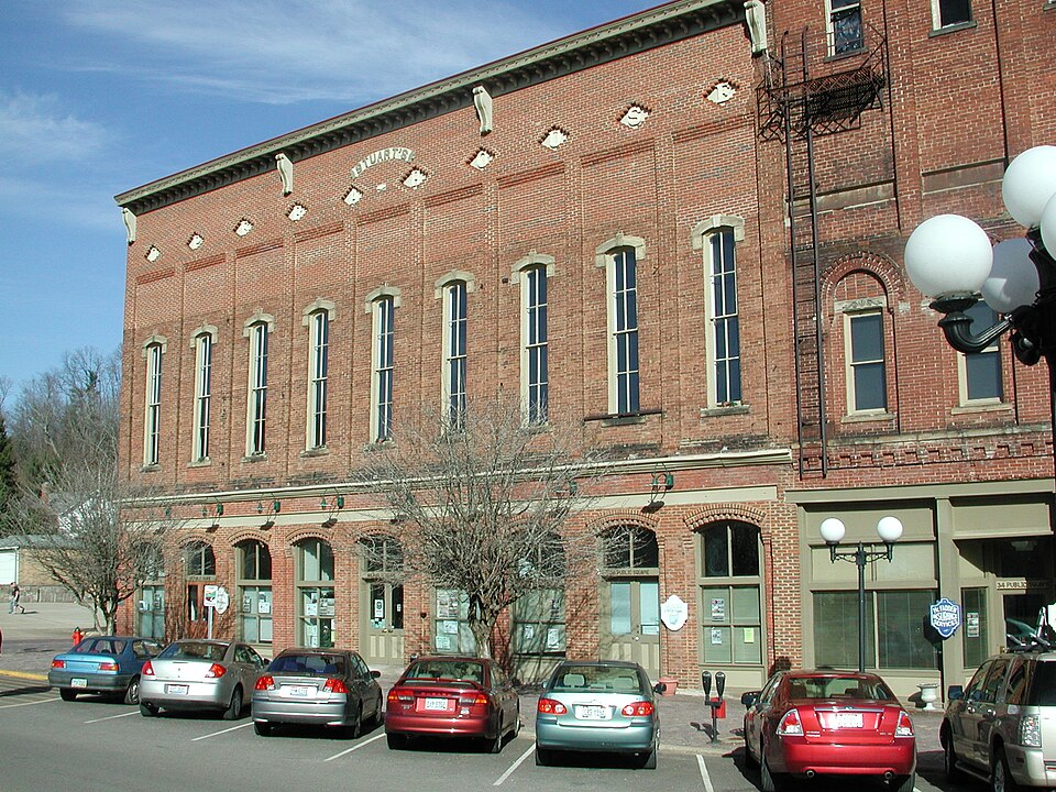
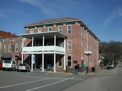
“Stuart's Opera House is a registered historic building in Nelsonville, Ohio, listed on the National Register on December 29, 1978. It is an Opera House and live music performance theatre that was built in 1879, and continues to be used to this day.”
Wikipedia article Stuart's Opera House, CC BY-SA 4.0.
one of 19 National Register listings in Athens County · listed in 1978 · category: Building · one of 1 National Historic Landmarks in Athens County.
National Register reference number.78002007- the number the National Park Service assigned this property when it was listed, and the key its nomination file is catalogued under at the National Archives.
Fires near this property
154 since 1993
Regional context, not property-specific
evidence. The
federal wildfire occurrence database
lists 154 fires within 5 miles of Stuart's Opera House between
1993 and 2020, burning about 277 acres in total. 2 started naturally. 4 were recorded as arson.
Distance is straight-line from the map coordinates, so a fire counted
here may appear on a neighbouring settlement's page as well.
Reported cause
Fires
Recreation and ceremony
76
Debris and open burning
38
Missing data/not specified/undetermined
10
Equipment and vehicle use
9
Power generation/transmission/distribution
8
Other causes
6
Arson/incendiarism
4
Natural
2
Smoking
1
The most recent of
them, most recent first, with the day each was reported and the service
that recorded it.
Regional context, not property-specific
evidence. Museums hold 236 specimens
collected within 10 miles of Stuart's Opera House between 1898 and
1975: 178 Animalia, 30 Plantae, 27 Fungi, 1 Unrecorded. 12 distinct Species records are shown.
Collected by A. D. Selby, Campbell, L. W. (Louis W.), Clifford M Wetmore and others. Each is a
physical object with a catalogue
number, and each entry opens the museum's record. This is what was
collected and kept, not a survey of what lives here - nothing can be
concluded from a species being absent.
Regional context, not property-specific
evidence. The federal mineral resources record lists
8 workings within 5 miles of Stuart's Opera House: 5 past producers, 3 producers.
3 still produce. What was taken out: Sand and Gravel, Construction, Clay, Coal. Distance is straight-line from the
map coordinates, so a quarry counted here may appear on a neighbouring
settlement's page as well.
Regional context, not property-specific
evidence. The National Weather Service names
Nelsonville, the town this property stands in, in 41 storm reports between 1994 and 2025: 18 thunderstorm wind, 14 hail, 5 flash flood, 3 flood.
The reports record 1 death. Each account below is quoted exactly as the forecast office
filed it, from the NOAA Storm Events Database, and each date
opens the federal record of that event.
Small streams across the northern portion of the county flooded. ||An elderly couple was driving home along Linscott Run. This is a small tributary to Federal Creek near Amesville. Close to home, the husband decided to stop his vehicle and wait out some high water. Their vehicle became surrounded by rising water. The couple made an attempt to walk to nearby higher ground. The wife was using a walker due to recent hip surgery. She slipped and the husband could not hold on to her. The current swept her away. The fire department located her body around dawn on the 5th, about a half mile downstream. The husband was helped to safety by neighbors using a garden hose. Route 550 was also flooded in Amesville. ||Several streets in Nelsonville were flooded including along Dorr Run and Pleasant View Road. Large dump rocks, used in the bypass construction, were even moved by the water. A wall to a garage was knocked over by the water. A house foundation was damaged.||A vehicle was flooded along Margaret Creek near Albany. The occupants were unhurt at a nearby home when the local fire department arrived.
Numerous trees or large branches fell across the county. Nearly 24,000 customers lost electricity. Damage assessment included 1 home destroyed, 4 with major damage, and 3 with minor damage across the county. The public infrastructure damage assessment was around $580,000.
Numerous small streams overflowed and blocked roads during the daylight hours on the 19th. The Hocking River then caused flooding into the 21st. Damage was mainly to roads and a few culverts.
Rain amounts of 2 to 2.5 inches fell in about 2 hours. A spotter reported 1.6 inches in an hour. The 24 hour rain total was 3.5 inches at Nelsonville. The town of Athens was just south of the heaviest rain with a 24 hour rain total of 1.8 inches. Small streams flooded and closed several roads. The stream gauge at Doanville on the lower reaches of Monday Creek rose 10 to 11 feet in a few hours.
Rains of 2 to 3.5 inches fell in less than 3 hours, in a northwest to southeast corridor, along the Hocking River Valley. An automatic gauge south of Nelsonville measured 3.5 inches of rain. In the city of Athens, 3.4 inches of rain was recorded. The Plains measured 3.1 inches. Streams flooded roads in such communities as Athens, The Plains, and Chauncey. The York Fire Department went to the aid of motorists stalled in water along township roads. No flooding of dwellings was known.
Around 1.5 inches of rain fell in less than an hour with the second cluster of storms, causing minor flash flooding. Several streets were flooded, but no dwellings were affected.
Several roads were flooded in Doanville, including Lang Road, Brady Road and Pancake Road due to high water on Monday Creek.||Monday Creek at Doanville rose above its bankfull level of 14 feet very early on the 4th. It crested at 16.3 feet, just above its 16 foot moderate stage that afternoon, and returned to its banks just before noon on the 5th.
Multiple roads were closed across Athens County due to high water. This included State Routes 13 and 685 near Glouster, and State Route 690 near Amesville.||Monday Creek also flooded at Doanville, where the gage showed the creek spilled from its banks just before noon on the 22nd. The creek crested around 18.6 feet, or about 2.5 feet above its 16 foot bankfull level, late that night. It then returned to its banks by 4 PM on the 23rd.
No historic map-sheet match is published
for this property yet. That does not mean no map exists. This record needs
a coordinate-quality review before it can be joined to a sheet boundary.
Browse the county's mapped places while that work is
pending.
Named in the fire insurance atlases
Sanborn surveyors printed an index of the
town's establishments at the front of each atlas. This property is named in
one, read straight off the scanned sheet.
When this property was proposed for the
National Register, someone wrote the case for it: what the building is,
and why it matters. That document is a federal record in the public domain.
It is quoted below word for word, never summarised. The text was read off the scanned case file by machine, so the
occasional stray character is the recogniser's and the 1970s
typewriter's.
Description of the property
Washington Street and the Public Square, Nelsonville, Ohio. The The interior of the opera house suffers from neglect. CONDITION UNEXPOSED EXCELLENT UNALTERED XGOOD in tact. house are storefronts of plastic and glass. of a large commercial structure on the southeast structure of in the era when electricity was used, and it was only turned on Stuart's Opera House occupies the second and third stories rear are also evidence of this lighting technique.
CHECK ONE nine recessed panels into which are set Victorian carved stone the largest and the first in l879 and two additions to the south building is Italianate in influence and was built in three sections, The front facade of the north end of the opera house has had been closed up for over 50 years as of 1978.All the original however the windows now bricked in on the north side of this later, in the Victorian mode, the second story windows have a different was sealed for so long, many of its treasures have been preserved lower portion of the building is used for storefronts.The section of the building is the oldest. The third section of the opera house, the south section, were built in 1882. 1882 addition, were originally for illumination of the stage area, Curtain" is stuck in place.
treatment, with only carved stone brackets above them. Chimneys are The RUINS The middle section, now comprising the stage area, is largest The arched windows on the third story in raised letters inset in diamond shaped openings.This north has a parapet entablature. The windows in this section third section houses the rehearsal stage area.The roof line lintels with a shield effect atop.
/ARCHITECT W.H. Vorhees Company STATEMENT OF SIGNIFICANCE increased the seating capacity, the stage area, and also constructed a huge scenery lot, with dressing rooms mounting from the wings. President Taft chose to visit Nelsonville, however, the crowds 1600-1699 1700-1799 INVENTION theatre. ARCHEOLOGY-HISTORIC CONSERVATION ART SIGNIFICANCE ARCHITECTURE AGRICULTURE LAW PERIOD MILITARY 1900- LITERATURE TRANSPORTATION INDUSTRY for several decades. _POLITICS/GOVERNMENT X1800-1899 The end of the canal days and the beginning of the railroad _EXPLORATION/SETTLEMENT The first labor union in Athens County, and the first mining union XTHEATER MUSIC _COMMUNICATIONS only source of culture in the rich mining area of southeastern Ohio things cultural.
The Opera House was on the Schubert circuit, and no vaudeville -1500-1599 started to arrive along with many other immigrants, most of whom proved to large for the Opera House, and both presidents were forced marked the start of the development of the Hocking Valley as a _COMMERCE _SOCIAL/HUMANITARIAN The Opera House was used for other functions, at times also. _ENGINEERING Stuart's Opera House is significant because from l879 to 1924 it was a center of professional theatrical activity in the The venture grew so rapidly that it was necessary in 1882 to enlarge to address the townspeople in the Public Square.
were educated and who brought with them from abroad a taste for The surrounding mining had no on _SCULPTURE -1400-1499 - PHILOSOPHY _SCIENCE W.J.Stuart built the Opera House in 1879 of brick made by - RELIGION _LANDSCAPE ARCHITECTURE great coal-producing field. Nelsonville grew rapidly after the ever played there. The Opera House was strictly for legitimate ARCHEOLOGY-PREHISTORIC the entertainment featured at Stuart's Opera House. hand from local surface clay on a large lot owned by his father. hotels and railroad lines made it attractive to performers. It was the 9
Quoted from the National Register nomination
for reference 78002007, 26 pages, held by the National Archives in Record
Group 79. See the
catalogue record.
Listed places nearby
3 within 8 miles
Other National Register properties close
enough to walk or drive between, ordered by distance from this one. Both
positions come from the same geocoding pass that matched these properties
to their map sheets.
Listing record. National Park Service National Register of Historic Places, listed-properties dataset, current to 2026-05-22.
Map join. Address geocoded through the United States Census geocoder, then tested against the published boundary of every sheet in the USGS Historical Topographic Map Collection.
How this page is made. Listing fields come from federal records; map-sheet coverage is a labelled coordinate-to-boundary calculation, not a source-field claim.
Wildfire. Short, Karen C. 2022. Spatial wildfire occurrence data for the United States, 1992-2020 [FPA_FOD_20221014]. 6th Edition. Fort Collins, CO: Forest Service Research Data Archive. https://doi.org/10.2737/RDS-2013-0009.6 Collected with United States Government funding and usable without additional permissions or fees.
Specimens. Global Biodiversity Information Facility (GBIF), https://www.gbif.org/. Only records licensed CC0 or CC BY are used. Records licensed CC BY-NC are excluded because this site carries advertising. Images are checked individually and any whose licence is non-commercial, no-derivatives or unreadable is refused.
Mines and quarries. USGS Mineral Resources Data System (MRDS) https://mrdata.usgs.gov/mrds/ A work of the United States government, no copyright under 17 U.S.C. 105.
Storms. NOAA National Centers for Environmental Information, Storm Events Database https://www.ncei.noaa.gov/stormevents/ A work of the United States government, no copyright under 17 U.S.C. 105. Narratives are quoted verbatim from the National Weather Service report and are not edited or summarised.
 Block
Block