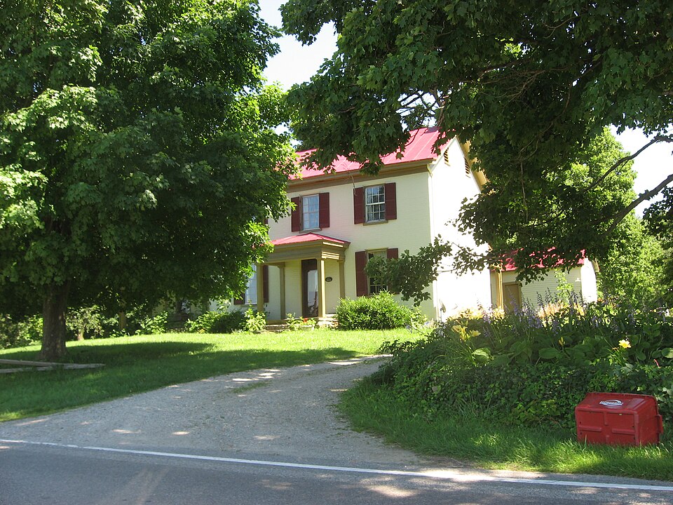
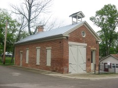
Listed on the National Register of Historic Places in
1978. A historic map-sheet match is not published yet. The record needs a coordinate-quality review before it can be joined to a sheet boundary.
From the record
“From the time of the first settlement until 1804, the post office was at Cincinnati. Residents relied more for their letters and news on emigrants than they did on the mail.”
The History of Warren County, Ohio (1882). Machine-read text.
one of 30 National Register listings in Warren County · listed in 1978 · category: Building.
National Register reference number.78002207- the number the National Park Service assigned this property when it was listed, and the key its nomination file is catalogued under at the National Archives.
The ground it stands on
18,319 words
The chapter on Wayne Township in The History of Warren County, Ohio, published 1882 names Waynesville. This is what it says, exactly as the scans read.
Before 1819, the channel of the river on the road to Corwin was not as now, but where the bridge now is was in the bend of a horseshoe, the channel above and below the bridge having been made since. The crossing of the river was between High and Main streets, in Waynesville. When the water was high, there was a ferry used, and when low, a ford. About 1812, an effort was made to build a bridge at the ford. The abutments were raised and a superstructure was placed on trestles. A freshet in the river swept out the work and no further effort was made to build a bridge at that place. In 1817, a bridge was built on a contract, where the bridge now is, by John Satterthwaite, for $700, including the abutments. It was built of oak timber, principally hewed, never covered or weather-boarded, and only lasted about ten years. At that time, the road crossed the West Branch of the Miami, known as the race at the mouth and followed the north bank of the Miami to the bridge. The race wsa then a small stream, no bridge over it; the ford was a very bad crossing.
In 1803 a store was kept at the east angle of the crossing of High and Third streets by David Holloway. A few years after, Jacob Pierson kept a store there for some time. Shortly after, a store was kept at the north angle of the same crossing, and in 1810 by Seth Silvers. In 1808, David Brown built a house on Outlot No. 4, Waynesville, and kept a small store there; in 1806, David Pugh had a store on Main street; in 1810, on the same street, by
Regional context, not property-specific
evidence. Museums hold 259 specimens
collected within 10 miles of McKay, Moses, House between 1844 and
1973: 240 Animalia, 12 Fungi, 4 Plantae, 3 Unrecorded. 12 distinct Species records are shown.
Collected by A. R. Gaufin, A.R. Gaufin, H.H. Ross, ANSEL JOHN and others. Each is a
physical object with a catalogue
number, and each entry opens the museum's record. This is what was
collected and kept, not a survey of what lives here - nothing can be
concluded from a species being absent.
Regional context, not property-specific
evidence. The federal mineral resources record lists
5 workings within 5 miles of McKay, Moses, House: 2 past producers, 2 producers, 1 plant.
3 still produce. What was taken out: Sand and Gravel, Construction. Distance is straight-line from the
map coordinates, so a quarry counted here may appear on a neighbouring
settlement's page as well.
Regional context, not property-specific
evidence. The National Weather Service names
Waynesville, the town this property stands in, in 24 storm reports between 1994 and 2011: 15 thunderstorm wind, 8 hail, 1 flash flood.
No death or injury is recorded in these reports. Each account below is quoted exactly as the forecast office
filed it, from the NOAA Storm Events Database, and each date
opens the federal record of that event.
No historic map-sheet match is published
for this property yet. That does not mean no map exists. This record needs
a coordinate-quality review before it can be joined to a sheet boundary.
Browse the county's mapped places while that work is
pending.
From the nomination file
2,195 words on record
When this property was proposed for the
National Register, someone wrote the case for it: what the building is,
and why it matters. That document is a federal record in the public domain.
It is quoted below word for word, never summarised. The text was read off the scanned case file by machine, so the
occasional stray character is the recogniser's and the 1970s
typewriter's.
Description of the property
built in 1818, from brick dug and fired on the site. Originally unpainted, the house of one of Ashur Benjamin's Carpenter's Assistant, published during the early 19th room, or parlor, the stairway leading from it to the room above is adorned with fine three fireplaces, a huge "walk-in" size fireplace being a focal point in the living tion, having been well-preserved by subsequent layers of wallpaper applied over it. ivy leaf. Downstairs in the living room, a chain swag of tear drop design appears in CONDITION MOVED UNEXPOSED DETERIORATED UNALTERED now covered with tin. FAIR XALTERED The interior of the six-room house contains the original wood doors, floors and trim, room. Also, there was a large "working" fireplace in the original kitchen.
black.It is possible that this stenciliing treatment appears throughout the house; retaining only the one in the parlor.An original door on the rear porch was partially random-width rough-sawn sheathing boards are still visible in the attic.The roof is with the existing concrete and stone porch and rail.According to Walter M.Macomber, is now painted white,with symmetrically arranged six-over-six double-hung windows, Exceptionally fine original hand stencilling appears l-l/2 feet down from the ceilings The Moses McKay House is a five-bay, two-story, brick structure with basement and attic, noted restoration architect of Washington,D.c.,who has examined the house,"the dark green tulip blooms.Another bedroom wall is stencilled with a dark blue-green but much of it retains its original stained hue.There is one remaining ornate fire- if so, it is a feature considered to be unusual in Warren County houses.
the front elevation is somewhat common in southern Ohio.
McKay, a devout Virginia Quaker, who had settled on fine farmland with his wife, eleven local craftsman's individual flair. Soon after the arrival of the Mckay family at their Ohio homestead, the slaves were however, chose to remain with the family and help develop the farm. In later years the McKay homestead passed to Moses McKay's grandson, Jonas T. Mckay, who and who shared the Mckay's Quaker zeal for aiding runaway slaves to freedom. Consequently, at a time could be accommodated in the Mckay's cellar under the floor of the original were warmed by charcoal piled on the floor. The cellar still exists, but the fireplace House, then to other "stations" in the area on the road to freedom. This route is said 1400-1499 1700-1799 movement.
1600-1699 PERIOD INVENTION EDUCATION SIGNIFICANCE ART ARCHEOLOGY-HISTORIC EXPLORATION/SETTLEMENT AGRICULTURE THEATER PREHISTORIC MILITARY SCULPTURE TRANSPORTATION XARCHITECTURE RELIGION INDUSTRY _POLITICS/GOVERNMENT A ladder made of a puncheon sapling lead down into the cellar which was circular in con- Greek Revival, southern Ohio farm house, whose distinguishing features described in is still visible in the pattern of later flooring used to cover the opening. 1900- children, and twenty slaves.
Architecturally, the house is a fine example of a modified to have been linked with a route which connected with the home of Daniel Webster.The decorative detail in the woodwork and other stylistic treatment are reflective of the - CONSERVATION the hidden cellar.The hearthstone had a bevelled edge so that it could be easily lifted.
Quoted from the National Register nomination
for reference 78002207, 23 pages, held by the National Archives in Record
Group 79. See the
catalogue record.
Listed places nearby
5 within 8 miles
Other National Register properties close
enough to walk or drive between, ordered by distance from this one. Both
positions come from the same geocoding pass that matched these properties
to their map sheets.
Listing record. National Park Service National Register of Historic Places, listed-properties dataset, current to 2026-05-22.
Map join. Address geocoded through the United States Census geocoder, then tested against the published boundary of every sheet in the USGS Historical Topographic Map Collection.
How this page is made. Listing fields come from federal records; map-sheet coverage is a labelled coordinate-to-boundary calculation, not a source-field claim.
Specimens. Global Biodiversity Information Facility (GBIF), https://www.gbif.org/. Only records licensed CC0 or CC BY are used. Records licensed CC BY-NC are excluded because this site carries advertising. Images are checked individually and any whose licence is non-commercial, no-derivatives or unreadable is refused.
Mines and quarries. USGS Mineral Resources Data System (MRDS) https://mrdata.usgs.gov/mrds/ A work of the United States government, no copyright under 17 U.S.C. 105.
Storms. NOAA National Centers for Environmental Information, Storm Events Database https://www.ncei.noaa.gov/stormevents/ A work of the United States government, no copyright under 17 U.S.C. 105. Narratives are quoted verbatim from the National Weather Service report and are not edited or summarised.
 Block
Block