Listed on the National Register of Historic Places in
1980. A historic map-sheet match is not published yet. The record needs a coordinate-quality review before it can be joined to a sheet boundary.
From the record
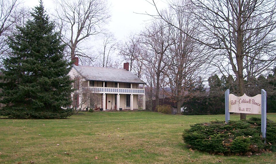
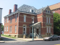
“The Samuel Caldwell House is a historic house in the village of Caldwell, Ohio, United States. Erected in 1832, it is the oldest house in the village.”
Wikipedia article Samuel Caldwell House, CC BY-SA 4.0.
one of 8 National Register listings in Noble County · listed in 1980 · category: Building.
National Register reference number.80003201- the number the National Park Service assigned this property when it was listed, and the key its nomination file is catalogued under at the National Archives.
Fires near this property
16 since 2012
Regional context, not property-specific
evidence. The
federal wildfire occurrence database
lists 16 fires within 5 miles of Caldwell, Samuel, House between
2012 and 2020, burning about 87 acres in total. 1 started naturally. 1 was recorded as arson.
Distance is straight-line from the map coordinates, so a fire counted
here may appear on a neighbouring settlement's page as well.
Reported cause
Fires
Debris and open burning
9
Missing data/not specified/undetermined
2
Equipment and vehicle use
2
Arson/incendiarism
1
Natural
1
Power generation/transmission/distribution
1
The most recent of
them, most recent first, with the day each was reported and the service
that recorded it.
Regional context, not property-specific
evidence. Museums hold 75 specimens
collected within 10 miles of Caldwell, Samuel, House between 1884 and
1974: 50 Animalia, 21 Plantae, 3 Fungi, 1 Unrecorded. 12 distinct Species records are shown.
Collected by Adams, W., Adler, K. K., Adler, K. K. & Dennis, D. M. and others. Each is a
physical object with a catalogue
number, and each entry opens the museum's record. This is what was
collected and kept, not a survey of what lives here - nothing can be
concluded from a species being absent.
Regional context, not property-specific
evidence. The federal mineral resources record lists
2 workings within 5 miles of Caldwell, Samuel, House: 1 past producer, 1 producer.
1 still produces. What was taken out: Clay, Stone, Crushed/Broken. Distance is straight-line from the
map coordinates, so a quarry counted here may appear on a neighbouring
settlement's page as well.
Regional context, not property-specific
evidence. The National Weather Service names
Caldwell, the town this property stands in, in 39 storm reports between 1994 and 2025: 15 thunderstorm wind, 12 flash flood, 6 hail, 6 flood.
No death or injury is recorded in these reports. Each account below is quoted exactly as the forecast office
filed it, from the NOAA Storm Events Database, and each date
opens the federal record of that event.
Between 3 and 4 pm EST, a total of 3 inches of rain was reported 4 miles south of Caldwell. The strong thunderstorm also dropped pea size hail. Other thunderstorms in the county also caused significant street flooding. Street flooding was first reported in Caldwell. Numerous small streams were reported out of their banks. The intersection of SR 260 and SR 724 near Carlisle was flooded. CR 12 and SR 821 near Ava was flooded. A 1-2 mile stretch of SR 513 between Summersfield and Batesville was flooded. SR 215 was closed near Belle Valley.
1 paper published in this town,
digitised by the Library of Congress and free to read: 0 issues,
0 pages. Every page is searchable, so a name or a street can be
looked for directly in what the town printed about itself at the time.
No historic map-sheet match is published
for this property yet. That does not mean no map exists. This record needs
a coordinate-quality review before it can be joined to a sheet boundary.
Browse the county's mapped places while that work is
pending.
From the nomination file
1,498 words on record
When this property was proposed for the
National Register, someone wrote the case for it: what the building is,
and why it matters. That document is a federal record in the public domain.
It is quoted below word for word, never summarised. The text was read off the scanned case file by machine, so the
occasional stray character is the recogniser's and the 1970s
typewriter's.
Description of the property
shelters the facade and is supported by brick posts, which replace earlier of the house in the 1920's. Condition ruins fair external louvered shutters. The interior has been altered very little, retaining original woodwork the length of the house;a one story frame section was added to the south end Check one and extended lug sills.Those on the north and south ends of the house feature is found in the second bay from the northern end.The door is trabeated and on There are four bays on the facade and three on the sides.The main entrance boxed cornice and chimneys at the gable ends.A two story open frame porch stairway from the kitchen. date This two story brick structure with stone foundation is rectangular in plan and features a frame section to the rear.
The roof is gabled with a restrained the lintel is inscribed"A.D.1832".Windows are 2/2with plain stone lintels - prehistoric - landscape architecture _ religion - archeology-prehistoric _ science _ sculpture _ architecture . education _ social/ . music _exploration/settlement _ theater - 1900- . industry - politics/government _ transportation person responsible for establishing the village of Caldwell, now the largest Robert, father of Samuel, surveyed that area of the state for General Rufus Putnam. century. As well as being a large-scale farmer, by 1836, Samuel Caldwell owned stock business in the county on this property. 1600-1699 1832 1500-1599 1400-1499 1700-1799 commerce communities.
art Builder/Architect economics communications philosophy engineering Period humanitarian agriculture literature conservation Specific dates law other (specify) X_1800-1899 successful agricultural enterprise.By 1880,his son was operating the largest The Caldwells distinguished themselves early in Noble County history. both a sawmill and a grist mill.
(in one paragraph) prominent in the Democratic Party, helping to establish schools and founding a of the large landholder/developer settlement pattern typical of many Ohio frontier soon after decided to name the town in his honor. invention first clearing in the area. military The farm remained in the Caldwell family until the 1920's.Although site was chosen in 1857 and Caldwell deeded the land to the county.It was of land to the county on the condition that it be platted and used as a county In the early 1850's Caldwell shrewdly offered to donate a vacant tract archeology-prehistoric X community planning it has been altered through frame additions, it remains largely intact. He settled on the 9.
Quoted from the National Register nomination
for reference 80003201, 18 pages, held by the National Archives in Record
Group 79. See the
catalogue record.
Listed places nearby
3 within 8 miles
Other National Register properties close
enough to walk or drive between, ordered by distance from this one. Both
positions come from the same geocoding pass that matched these properties
to their map sheets.
Listing record. National Park Service National Register of Historic Places, listed-properties dataset, current to 2026-05-22.
Map join. Address geocoded through the United States Census geocoder, then tested against the published boundary of every sheet in the USGS Historical Topographic Map Collection.
How this page is made. Listing fields come from federal records; map-sheet coverage is a labelled coordinate-to-boundary calculation, not a source-field claim.
Wildfire. Short, Karen C. 2022. Spatial wildfire occurrence data for the United States, 1992-2020 [FPA_FOD_20221014]. 6th Edition. Fort Collins, CO: Forest Service Research Data Archive. https://doi.org/10.2737/RDS-2013-0009.6 Collected with United States Government funding and usable without additional permissions or fees.
Specimens. Global Biodiversity Information Facility (GBIF), https://www.gbif.org/. Only records licensed CC0 or CC BY are used. Records licensed CC BY-NC are excluded because this site carries advertising. Images are checked individually and any whose licence is non-commercial, no-derivatives or unreadable is refused.
Mines and quarries. USGS Mineral Resources Data System (MRDS) https://mrdata.usgs.gov/mrds/ A work of the United States government, no copyright under 17 U.S.C. 105.
Storms. NOAA National Centers for Environmental Information, Storm Events Database https://www.ncei.noaa.gov/stormevents/ A work of the United States government, no copyright under 17 U.S.C. 105. Narratives are quoted verbatim from the National Weather Service report and are not edited or summarised.
 Block
Block