U.S. Coast Guard Cape Cod Canal Station, Off Coast Guard Road, about 1 mile north of U.S. Route 6A intersection, Sandwich
U.S. Coast Guard Cape Cod Canal Station, Off Coast Guard Road, about 1 mile north of U.S. Route 6A intersection, Sandwich, Barnstable County, MA. Surveyed as HABS MASS,1-SAND,2-, with 1 photograph and a 2,187-word written history.
From the record
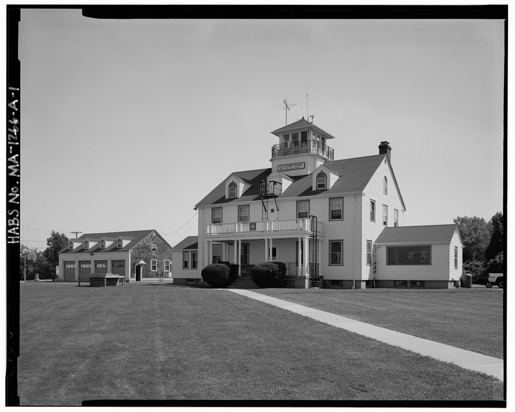
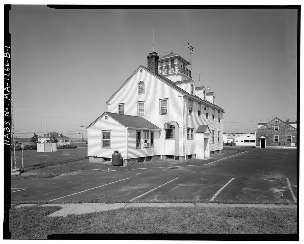
“The Cape Cod Canal Station consists of three Colonial Revival, wood-framed buildings: a 2- 1/2 story station house, a story boathouse, and a story garage/equipment building.”
Written record, HABS MASS,1-SAND,2- survey. Machine-read text.
surveyed by the federal HABS program as HABS MASS,1-SAND,2- · the record runs 2187 words · one of 148 surveyed structures published for this county.
1 photograph from the federal survey record, Library of Congress.
Location
46 words
Source document
Quoted word for word from HABS MASS,1-SAND,2-.
Not written, edited or summarised by this site.
Off coast Guard Road, approximately 1 mile north of the intersection of Coast Guard Road and U.S. Route 6A, 2 miles north of the Sagamore Bridge, in proximity to the Cape Cod Canal, in Sandwich, Barnstable County, Massachusetts USGS Sagamore, MA Quandrangle, Universal Transverse Mercator Coordinates:
Significance
1221 words
Source document
Quoted word for word from HABS MASS,1-SAND,2-.
Not written, edited or summarised by this site.
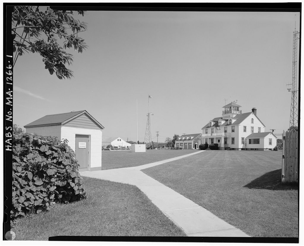
The Cape Cod Canal Station consists of three Colonial Revival, wood-framed buildings: a 2- 1/2 story station house, a story boathouse, and a story garage/equipment building. The station house, boathouse and equipment buildings were constructed as a support complex for the activities of the live-saving station following the demolition of the original facility at a site nearby with the widening of the Cape Cod Canal in The new facility provided space for the central administrative and social support functions of the station following a standard Colonial Revival-styled module employed elsewhere by the Coast Guard for similar facilities during the period. Similar-styled U.S.
Coast Guard station complexes, built under federal New Deal WPA/PWA initiatives during the period, exist in the New England coastal region. U.S. COAST GUARD CAPE COD CANAL STATION HABS No. MA-1266 (Page 2) Historical Information: Construction of a Coast Guard life-saving station at the eastern end of the Cape Cod Canal was determined by the construction of the canal between and the canal's subsequent enlargement and widening between The original station was constructed in or before and located on the canal bank. Improvements to the canal made during the period necessitated the demolition of the original station and the building of a new station house in its present form and location.
Built to assist the safe passage of shipping between New York city and Boston, the Cape Cod Canal became a favored alternative travel route to the treacherous shoals off Cape Cod and Nantucket. Location of a life-saving station at the Cape Cod Bay entrance afforded timely assistance and policing of ship and recreational boating traffic not only for the canal but for the western end of Cape Cod Bay as well. The station complex was enlarged during World War II, including the construction of barracks halls, enlargement of the equipment building and additional observation tower space (watch house). During World War II, the Cape Cod Canal became a primary safe shipping route along the coast.
The Buzzard's Bay end of the canal was used to coordinate the assembling of convoys of vessels, both merchantmen and war supply ships. The protected area south of the Cleveland Ledge Light became filled with ships having arrived at this anchorage on their own from points south along the coast to await the formation of convoys. These ships would then traverse the canal in single file and be escorted as convoys up the coast to Halifax or directly across the Atlantic to Great Britain. As many as eighty ships would be organized into convoys. A Port Director's Office was set up in Wood's Hole to supervise convoy organization. Voyaging around the Cape, outside of the net of protection was dangerous during the War.
This area was known for German U-Boat activity and several ships attempting the route were torpedoed. The responsibility for canal operations during World War II was transferred to the U.S. Coast Guard and Navy. The principal operation headquarters was moved from the Buzzard's Bay entrance of the canal to the Coast Guard Station at Sandwich. Barracks were erected at the station to house additional personnel required for convoy escort duty. Each ship passing through the canal in convoy required two Coast Guard personnel on board while in the canal. Personnel were taken off the ships when they cleared the waterway. The station house observation tower was enlarged during this period to accommodate additional activity. During the war, the traffic load on the canal was intense.
The total cargo tonnage of the three years, was tons. A record use of the canal was set in with tons of cargo U.S. COAST GUARD CAPE COD CANAL STATION HABS No. MA-1260 (Page 3) transported. Prewar shipping records indicate that prior to the canal routinely had over ships traversing its waters. The canal was used by nearly ships in It is assumed that during the War, an equal if not greater number traversed the area. In the Coast Guard and Navy returned control of the canal to the Army Corps of Engineers. More recently the observation tower/watch house was essentially restored to its original exterior configuration. The barracks halls were removed prior to Within the last decade, ownership of the boathouse has been transferred to the Army Corps of Engineers and it is now vacant.
The marine launchways associated with the boathouse have been removed. Descriptive Information: The Cape Cod Canal Station consists of several buildings directly related to the original functional use of the facility as a lifeboat station. Dominated by a story Colonial Revival station house patterned after a large residence, the facility consists of two additional buildings; a story Colonial Revival boathouse, and a story Colonial Revival garage/equipment building. The boathouse is situated directly on the canal. The station house and equipment building are located in close proximity approximately 200 yards inland across an access road and wide lawn. The only additional building of the complex is a small concrete block, gable-roofed paint storage building.
Architecturally, the station complex embodies the Roosevelt New Deal era public works projects utilized for rehabilitating Coast Guard facilities in the period elsewhere in the New England Mid-Atlantic region. The result of this activity is the ubiquitous red-roofed, white-painted, Colonial Revival-styled, Coast Guard facility exemplified by the Cape Cod Canal Station. Similar station facilities are located at Montauk, Long Island, New York; Block Island and Point Judith, Rhode Island; Menemsha Harbor, on Martha's Vineyard, Massachusetts and at Eastham on Cape Cod, among others. The design of the station house, equipment building and boathouse is derived from prototypes developed by the U.S Coast Guard and its predecessor agency, the U.S.
Lifesaving Service (prior to In successive renovation and building programs, the space planning and architecture of these facilities evolved into a specialized building form for their functional use to provide round-the-clock personnel and services for saving lives efficiently during maritime disasters. The Cape Cod Station exemplifies not only the spurt of activity in rebuilding and renovating stations during the New Deal era, but also the concurrent application of the Colonial Revival U.S. COAST GUARD CAPE COD CANAL STATION HABS No. MA-1266 (Page 4) style to the design of facilities to produce an appropriate regional Coast Guard architecture. This architecture blends with the historical New England coastal village environment and yet remains identifiable as a Coast Guard facility.
SOURCES OF INFORMATION ARCHITECTURAL DRAWINGS, SPECIFICATIONS AND RELATED CORRESPONDENCE Records of the U.S.Coast Guard, Record Group 26, Judicial, Fiscal and Social Branch, Civil Archives Division, The National Archives, Washington, DC. United States Coast Guard Civil Engineering Unit Plans and Drawings, Correspondence, in the files of the U.S.Coast Guard Civil Engineering Unit Providence, Warwick, RI. (This archive includes a substantial number of original construction blueprints, as-builts and site plans.) U.S. Coast Guard Civil Engineers Office, Washington, DC, "Cape Cod Canal Station Plot Plan & Profile," December 12, U. s. Coast Guard Engineering First District, Boston, "Cape Cod Canal Lifeboat station Road Improvements I II January 1, U.S.
Coast Guard 1st Naval District, Boston, Mass., "Cape Cod Canal LB Station, New Signal Platform & Addition to Watch House," January 8, HISTORIC VIEWS/PHOTOGRAPHS Photographs of the United States Coast Guard Cape Cod Canal Station, Historian's Office, U.S. Coast Guard Headquarters, Washington, (This archive includes a set of 19 views of the Station House and Equipment Building under construction in BIBLIOGRAPHY PRIMARY AND UNPUBLISHED
SOURCES
815 words
The headings the report itself prints. Each one jumps to where it begins.
Source document
Quoted word for word from HABS MASS,1-SAND,2-.
Not written, edited or summarised by this site.
Massachusetts Historical Commission, Inventory Form - Cape Code Canal Station," Massachusetts Historical Commission, Boston, MA, date unknown. Weinstein, Stephen D. and John Ellis Associates, Historic Survey and Inventorv of Selected Real Property Facilities, United States Coast Guard, First District, Coast Guard Station Cape Cod Canal, Sandwich, Massachusetts OPFAC New York, NY U.S. COAST GUARD CAPE COD CANAL STATION HABS No. MA-1266 (Page 5) York, Eugene V., The Architecture of the United States Life- saving Stations, a Master of Arts thesis, Boston University Graduate School of Arts and Sciences, SECONDARY AND PUBLISHED Baars lag, Kar 1. Coast Guard to the Rescue. Farrar & Rinehart, Inc., NY, Capron, Walter c. The U.S.Coast Guard, Franklin Watts, Inc., New York, Craig, Lois.
The Federal Presence, Architecture, Politics, and Svmbolism in United states Government Building, MIT Press, Cambridge, MA, Farson, Robert H. The Cape Cod Canal, Wesleyan University Press, Middletown, CT, Powell, Hickman. What the Citizen Should Know About the Coast Guard, W.W.Norton & Company, Inc., New York, Reid, William James. The Building of The Cape Cod Canal privately printed, George McKibbin and Son, Inc., New York, NY, LIKELY SOURCES NOT YET INVESTIGATED Records of the Public Works Administration/Works Project Administration/ Federal Architecture Project in The National Archives, Washington, DC. The following sources cited by The Massachusetts Historical Commission may yield additional information: Cape Cod Canal Construction Co. booklet, in archives of Sandwich Public Library.
Files of the Sandwich Independent at Sandwich, MA. Gurney, Gene. The United States Coast Guard - A Pictorial History, Crown, NY. Records of the Civil Engineering Unit, First Coast Guard District, 150 Causeway Boston, MA. Oral sources: Mr. Benjamin Harrison, Buzzards Bay (sic) Mr. Donald Small, Sagamore, MA U.S. COAST GUARD CAPE COD CANAL STATION HABS No. MA-1266 (Page 6)
Project Information
The preparation of written, graphic and photographic documentation for the station house and equipment buildings has been undertaken as mitigation, in part, for the proposed rehabilitation/new construction of these buildings to meet the demands of an expanded program. The rehabilitation project includes expansion of the existing station house building extensions (wings) and additions to the equipment building. The project will have an adverse effect on these historic resources. Mitigation was reached through a Memorandum of Agreement (MOA) between the U.S. Coast Guard, the Massachusetts Historical Commission and the Advisory Council on Historic Preservation. The written, graphic and photo documentation was compiled in August-October Prepared by: Richard C.
Youngken Title: Architectural Historian and Planning Director Affiliation: The Newport Collaborative, Inc. Date: October 26, U.S. COAST GUARD CAPE COD CANAL STATION HABS No. MA-1266 (Page 7) LOCATION PLAN : ~. ~ . . \\ .. ~~ ; ; 0 (, \. .. : . ~. / "'~ p. .. :r 0 - ~ u Source: U.S. Coast Guard Civil Engineer's Office, Washington, DC. "Cape Cod Canal Station, Plot Plan & Profile, Third District, Mass., December 12, U.S. COAST GUARD CAPE COD CANAL STATION HABS No. MA-1266 (Page 8) PROPERTY FEATURES CIRCA 'q ~ _,_ -- -. __ . .- .. ~. /!IOSTDN.. CDD 44t'DNetf' YOl'lJ< CANRL CO. . ,.- -- ~- 1 -~~ U...3~e"'1.T-e~SE;z A0n.J.21J11111C.23. / .,. -;.~=;~:-~---Ji~;~;~.~- SUzhs ' '' : '"-~.~~\~~]ditl~~ft!.HHD a~rHOVSE. ~...~cisi~_:mt~oa'o~ . . . ' ::;;::....,~~'"i} - ~ .: .
'- Source: Boston, Cape Cod and New York Canal Co., "Land in Sandwich Between Stations 20 & 23 Deeded to the United States for a Coast Guard Boathouse," (circa U.S. COAST GUARD CAPE COD CANAL STATION HABS No. MA-1266 (Page 9) PROPERTY FEATURES ~( Co Block
Block