Post-Cold War downsizing has resulted in a number of necessary changes to Cold War era facilities. Two of the PAVE PAWS sites (Texas and Georgia) are no longer operational and have been partially dismantled. Several engineering projects required at the Cape Cod site have been determined to have adverse effects on the historic integrity of the radar facility. The Air Force, State Historic Preservation Officer, and the Advisory Council on historic preservation entered into a Programmatic Agreement, which calls for documentation of the Cape Cod site prior to any adverse action. This package fulfills the stipulation for HABS/HAER documentation noted in that agreement. Prepared bv: Mandy Whorton, Environmental Scientist, Argonne National Laboratory, 200 Union Ste.
Lakewood, Colorado 17 April CAPE COD AIR STATION HAERNo.MA-151 (Page 2) Summary Description of Cape Cod Air Station and Its Setting Cape Cod AS is located across the Sagamore Bridge off the coast of Cape Cod Bay, about 60 mi southeast of Boston. Cape Cod AS comprises 100 acres of leased land in the northeastern boundary of the state-owned Massachusetts Military Reservation a 20,000-acre parcel of land that houses a variety of military units, including units of the Air National Guard, Army National Guard, U.S. Coast Guard, and Cape Cod AS. The area is generally forested and relatively flat. The technical facility is located on the second highest point on Cape Cod at 255 ft above sea level. Cape Cod Air Station was constructed in as the first of four sties in the U.S.
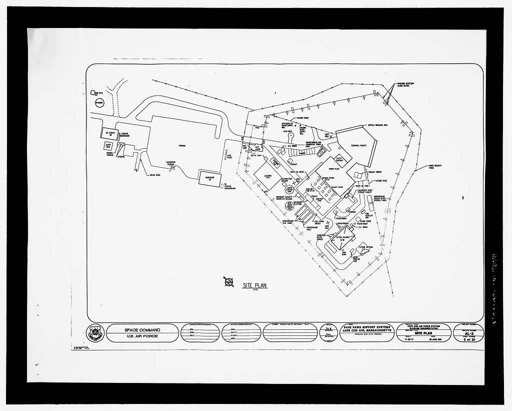
for the PAVE (Air Force program name) PAWS (Phased Array Warning System)1 for the early detection of submarine-launched ballistic missiles and intercontinental ballistic missiles (ICBMs). The Cape Cod complex consists often buildings, including a joined technical facility and power plant (HAER No. MA-151-A) as well as ancillary structures, including a guardhouse, storage warehouse, satellite communications building (vacant), office building, and utilities and fuel storage structures. Most of the structures are within the restricted area, which is surrounded by a security fence. Armed security forces monitor all activity around the site; they are assisted by numerous cameras and motion detectors located along the security fence.
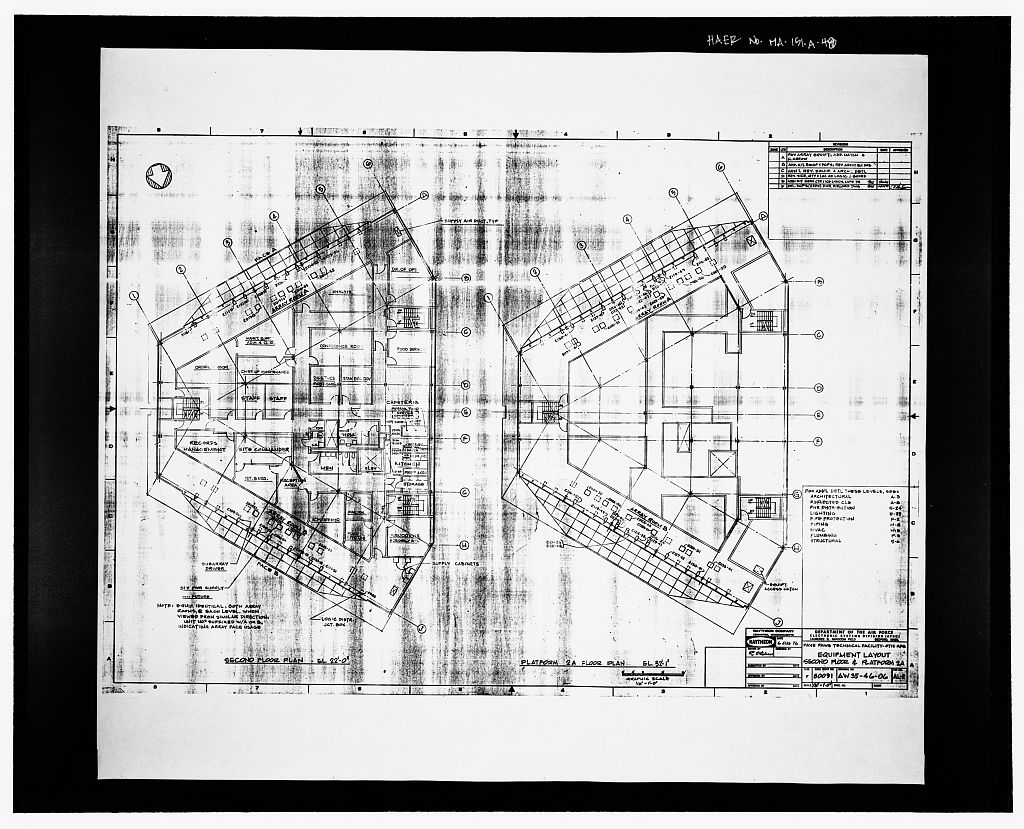
Security personnel are on duty 24-hours a day and constitute approximately one-quarter of all installation personnel. All buildings are steel-framed and clad with light beige metal paneling. The buildings within the restricted area are constructed on an elevated concrete pad, which also has been cleared of all landscaping and plant material. The main mission activity at the installation centers around the Technical Facility/Scanner Building (HAER No. MA-151-A), which houses the AN/FPS-1152 radar and related equipment that detects and tracks and ICBMs aimed at the continental U.S., Alaska, and northern Canada.
Cape Cod AS PAVE PAWS Site 1 provides coverage for a 3,000-mi area from the Atlantic, Caribbean, and northwest Arctic Ocean regions and has the power and sensitivity to detect an object as small as 10 m2 at this distance. Once a ballistic missile has been detected, the system can track the missile or any of its components as small as 1 m2. Data generated by the system are transmitted to Air Force control centers and the Pentagon. In addition to ballistic missile detection and tracking, PAVE PAWS Site 1 also participates with other radar sites in detecting, tracking, and identifying space objects. 1 Early reports translate the PAVE acronym as Precision Acquisition Vehicle Entry. It is also referenced in some documents as Perimeter Acquisition Vehicle Entry.
Recent Air Force materials on the system, however, distance themselves from these designations and characterize it instead as an inconsequential program name. 2 The PAVE PAWS expansion with facilities in Georgia and Texas used upgraded radar, the AN/FPS-123. PAVE PAWS radar at the first two sites, including Cape Cod, is sometimes referred to with this designation. CAPE COD AIR STATION HAERNo.MA-151 (Page 3) Historical Significance of Cape Cod Air Station Cape Cod Air Station is the site of the first U.S. early warning phased array radar. Its radar facility and power plant meet the criteria for inclusion in the National Register of Historic Places based on their association with important events in the Cold War between the U.S. and U.S.S.R.
The design and deployment of the dual-faced phased array radar also meets the criteria for significant engineering design. Historical Development of PAVE PAWS The U.S. developed PAVE PAWS to guard the ocean flanks of North America from the threat of The original deployment of PAVE PAWS units covered the Atlantic and Pacific oceans, but facilities were later constructed to cover the Caribbean as well. The widespread deployment of represented an important shift away from the "polar concept" that had dominated strategic defense during the first half of the Cold War (Schaffel The polar concept reflected the fact that Soviet long-range bombers and ICBMs were confined to bases on the territory of the U.S.S.R. and limited to attack routes across the polar region.
Khrushchev's attempt to circumvent these limits to Soviet strategic offensive capability (which was especially weak in by deploying intermediate range ballistic missiles (IRBMs) and bombers at forward bases in the Caribbean provoked the Cuban Missile Crisis. By the early however, the Soviet Union had achieved effective forward deployment around the North American continent on submarines.
Despite limitations on command and control (given the constraints of communication with vessels submerged in deep water), the presence of nuclear submarines contributed significantly to the superpower balance of the Even assuming high failure rates, the submarine forces deployed by both sides by the could have destroyed most or all of the major urban centers of either country, which represented an unacceptable loss (Daniel The U.S.S.R. had successfully launched an (the Sark) as early as but it had been fired from a diesel-powered submarine on the surface and had a range of only 350 miles.
While the U.S.S.R, continued to make technological advances in their submarines and in the and a number of factors including crude engineering, a shortage of maintenance crews, limited submarine and missile ranges, and changes in Soviet military thinking . limited the strategic offensive potential of these early submarines and ballistic missiles (Zaloga Catudal It was not until the late that the U.S.S.R. commissioned its first modern nuclear submarine (code-named "Yankee"). By two Yankee Class submarines, each carrying 16 with ranges of up to mi, were patrolling the east coast of the U.S. (Moore and Compton-Hall The U.S. responded to the new, although limited, threat of the U.S.S.R. fleet with the construction of conventional radar detection and tracking system.
The system consisted of CAPE COD AIR STATION HAERNo. MA-151 (Page 4) seven AN/FSS-7 radar sensors located along the coastal perimeters of the U.S. The radars were deployed on the east coast at MacDill APB (Florida), Fort Fisher Air Force Station (AFS) (North Carolina), and Charlestown AFS (Maine); on the west coast at Mount Hebo AFS (Oregon), Mill Valley AFS (California), and Mount Laguna AFS (California); and on the Gulf Coast at Laredo AFS (Texas). All sites became operational in (Pretty Throughout the the U.S.S.R. continued to improve the designs of and deploy in greater numbers SLBM-equipped nuclear submarines. By 34 Yankee Class submarines were operating off both coasts of the U.S., and in the first "Delta" Class submarines were deployed.
This class of submarine was equipped with the world's first long-range mi) the The extended range of the Delta submarines meant that they could strike targets from nearby coastal waters, and, in some cases, from their homeports. During the U.S.S.R. systematically deployed nuclear submarines off the U.S. coasts in an effort to reach ,parity with U.S. capabilities (Watson Although these deployments were aggressive, unlike the Cuban missile crisis of they were executed conservatively. By the end of the the Soviets had developed a competent ballistic-missile equipped submarine force that provided a balance to U.S. capabilities in this area (Watson As the U.S.S.R. developed and deployed a more advanced SLBM-equipped submarine fleet, the conventional AN/FSS-7 radars became obsolete.
Each of these radars, which were designed by Avco Electronics Division, had a parabolic antenna that performed, in conjunction with automated computer controls, both search and tracking functions. The radars had limited ranges mi), moved mechanically, and could only track single objects. To guard against the more advanced Soviet submarine fleet, the U.S. constructed a new phased array missile early warning system. Planning for the new system, called PAVE PAWS, began in it was commissioned in The first two PAVE PAWS sites were completed at Otis AFB in Massachusetts (renamed Cape Cod AS) and Beale AFB in California by and became operational in and respectively. The AN/FSS-7 radars were dismantled when these PAVE PAWS units became operational.
Development and Use of Phased Array Radar Phased array radars aim electronically rather than mechanically. The radars have flat faces covered by thousands of individual antenna elements incorporated into the exterior wall(s) of a large building. Each antenna emits a tiny portion of the radar beam. The array of receiving 3 The U.S.
enjoyed significant naval superiority throughout the Cold War, but one milestone that the Soviets did meet first was the development of the ultra-long-range The first appeared eight years before the MIRVed Trident The reason that the Soviets were to the first to develop this capability was probably a combination of a need to compensate for the fact that their submarines could not be deployed for long periods of time because of maintenance problems coupled with geographic limitations that did not provide much strategic flexibility in planning a route to the U.S. CAPE COD AIR STATION HAERNo.MA-151 (Page 5) elements is fixed, but the beam can scan and adapt its position nearly instantaneously by adjusting the current through the array of antenna elements.
As a result, phased array radars can detect and track a greater number of objects simultaneously and with far greater precision than conventional radars (Brookner Billetter Radar systems specifically designed for detecting and tracking missiles and orbiting satellites are very large and require immense electrical power to operate. Such radars might be required to have maximum ranges of to miles, compared with a typical range of 240 miles for a long-range aircraft detection system. Because of the need for an extended range, missile tracking systems operate with a power level about 100 times greater than the power required for aircraft detection. Antennas for missile detection are also very large and can be up to wide.
Development of this technology began in the mid-1960s and had been used in a limited way for missile tracking before the deployment of PAVE PAWS. Large, ground-based phased array radar was first deployed at Eglin AFB in for use in tracking space objects. This facility was expanded in with a secondary mission to detect and track replacing the coverage of the Texas AN/FSS-7 site (Klass The AN/FPS-85 radar at Eglin had separate array faces for transmitting and receiving. Also in two phased array facilities became operational at the Safeguard ABM Complex in North Dakota for ICBM warning; these radars were north-pointing.
(A full-size test facility for the Safeguard radar also was constructed on Kwajalein Atoll in the Marshall Islands in Two years later, the Cobra Dane phased array radar was deployed at Shemya Island in the Aleutians to monitor Soviet missile tests near the Kamchatka peninsula. Cobra Dane also had a secondary mission of tracking space objects and providing early warning of missile attacks in the northern Pacific. The first two PAVE PAWS sites in Massachusetts and California represented the first two-faced phased array radars deployed by the U.S. In the late two of the three Ballistic Missile Early Warning System (BMEWS) sites were upgraded to phased array using the PAVE PAWS design. BMEWS was the first ballistic missile detection and tracking system deployed by the U.S.
Operational in the late BMEWS relied on mechanical radar technology. The third BMEWS site is scheduled for upgrade to phased array radar in The phased array radar structures employ a number of common characteristics, including size, geometric shape, construction materials, circular array placement, and consolidated functions*. All of the structures are very large to accommodate the large size of the radar face(s) - the largest at Eglin measures 350 ft by 155 ft for its receiving component and 350 ft by 95 ft for its transmitting component. The PAVE PAWS faces are all square, measuring approximately 100 ft by 100 ft. With the exception of Eglin, the facilities are trapazoidal in shape with one to three faces offering 120 to 360 degrees of coverage.
The early facilities were constructed of reinforced concrete to provide protection against a nuclear blast. Later models, including PAVE PAWS, are steel structures with insulated aluminum panels on reinforced concrete pad foundations. The modification of the design was initiated for cost savings and reduced CAPE COD AIR STATION HAERNo.MA-151 (Page 6) construction time. The array pattern for the large phased array radars is circular. At the center (boresight) of the radar face, the elements are dense, becoming less dense closer to the circumference of the face. Not all of the antenna elements are active (i.e., not connected to wave tubes or power) but could be hooked up should additional capabilities be required. Thus, the radar facilities were designed with upgrades in mind.
Finally, the buildings are self-contained with radar, processing, and analysis, and amenity (e.g., dining and leisure) functions under one roof. Sources of Information/Bibliography Engineering drawings 134 Architectural, Structural, and Mechanical Construction drawings, dated August 6, by Raytheon Company, are the property of the United States Air Force, Space Command, Cape Cod Air Station. 21 Architectural Site Baseline Documentation drawings, dated 25 June by the US Air Force Space Command, are the property of the United States Air Force, Space Command, Cape Cod Air Station. Historic Views Nine (9) historical photographs, ca. (the photographer unknown) are the property of the United States Air Force, Space Command, Cape Cod Air Station. Interviews: Ms.
Nancy Fisher, Raytheon Support Services Company, Environmental Coordinator, PAVE PAWS Site 1, Cape Cod Air Station, June Mr. John P. Diehl, Raytheon Support Services Company, Civil Engineering Manager, PAVE PAWS Site 1, Cape Cod Air Station, June Mr. Les Easton, Raytheon Support Services Company, PAVE PAWS Site 2 Civil Engineering Manager, Beale AFB, November Dr. Coy Cross II, 9 RW/HO Historian, Beale AFB, November Mr. Bill Head, Robins AFB Historian, November Mr. Ray Hartsell, Raytheon Support Services Company, PAVE PAWS Site Manager, Site 3, Robins AFB, November Mr. Jim Newton, Raytheon Support Services Company, PAVE PAWS Civil Engineering Manager, PAVE PAWS Site 3, Robins AFB, November Dr, Richard Sturdevant, AFSPC Historian, Peterson AFB, Colorado, September January and March and Dr.
Richard Ekert, AFSPC Historian, Peterson AFB, Colorado, September and March Bibliography Billetter, Multifunction Array Radar. Norwood, MA : Artech House CAPE COD AIR STATION HAERNo.MA-151 (Page 7) Brookner, E. (editor). Practical Phased-Array Antenna Systems. Norwood, MA: Artech House. Catudal, Soviet Nuclear Strategy From Stalin to Gorbechev. Atlantic Highlands, NJ: Humanities Press International, Inc. Daniel, Anti-submarine Warfare and Superpower Strategic Stability. Urbana: University of Illinois Press. Klass, PJ. Radar Expands to Cover Aviation Week & Space Technology. 94(February Moore, J.E. and R. Compton-Hall. Submarine Warfare Today and Tomorrow. Bethesda, MD: Adler&Adler. Pretty, Jane's Weapon Systems ed.). London: Jane's Publishing. Schaffel, K.
The Emerging Shield: The Air Force and the Evolution of Continental Air Defense Washington, DC: Office of Air Force History. Watson, Red Navy at Sea: Soviet Naval Operations on the High Seas Boulder, CO: Westview Press. Zaloga, Target America: The Soviet Union and the Strategic Arms Race, Novato, CA: Presidio Press. Likely sources not yet investigated: Many materials of interest to the PAVE PAWS program and Cape Cod Air Station operations remain classified and were not included in this history. Classified documents available at the Air Force Historical Research Agency, Maxwell AFB, Montgomery, Alabama may contain useful information on the system and historical operations at Cape Cod Air Station.
Consideration should be given to a classified review or to future review as documents become declassified. Additional interviews could be conducted with early PAVE PAWS Program Managers, including Mr. Richard L. Moore, as well as military commanders that served at the site during its period of significance. Supplemental material: None. > - lit J 2. < S 3*- a o IJJ o t- 3 & > > N > HA R /fe, MA-in (P4$e. to)
 Block
Block