 Block
From the record
16 National Register listings published here.
Sources: the National Register database, National Park Service
27 topographic sheets cover 22 settlements here, and 16 properties are on the National Register of Historic Places.
16 National Register listings published here.
Sources: the National Register database, National Park Service
Every property in this county listed on the National Register of Historic Places, with the year it was listed and the federal nomination document.
| Photograph | Property | Type | Listed | Reference |
|---|---|---|---|---|
 | Beckwith House Hotel | building | 1991 | 91001389 |
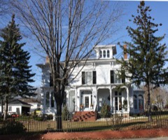 | Nelson F. Beckwith House | building | 1990 | 90000575 |
 | Berlin High School | building | 2016 | 16000465 |
 | Berlin Post Office | building | 2000 | 00001248 |
 | Green Lake County Courthouse | building | 1982 | 82000672 |
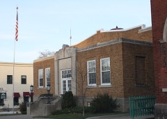 | Green Lake Village Hall | building | 2004 | 04000997 |
 | Huron Street Historic District | district | 1992 | 92001140 |
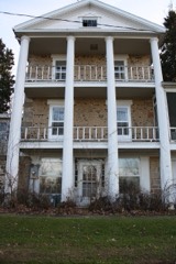 | Daniel and Caltherine Ketchum Cobblestone House | building | 2001 | 01000397 |
| J. P. Luther Company Glove Factory | building | 1997 | 97000267 | |
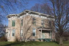 | McClelland-Kasuboski House | building | 1998 | 98000878 |
| Methodist Episcopal Church | building | 2021 | 100006107 | |
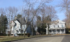 | Nathan Strong Park Historic District | building | 2005 | 05000423 |
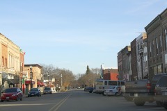 | Princeton Downtown Historic District | district | 1997 | 97000271 |
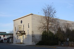 | Thrasher's Opera House | building | 1999 | 99000921 |
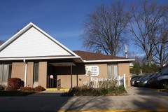 | Wisconsin Power and Light Berlin Power Plant | building | 1992 | 92000157 |
Every wildfire the federal occurrence database records inside this county: 529 of them, burning about 1,887 acres. 4 started naturally and 42 were recorded as arson. Each settlement page carries the fires within five miles of it.
| Reported cause | Fires |
|---|---|
| Debris and open burning | 232 |
| Equipment and vehicle use | 115 |
| Missing data/not specified/undetermined | 68 |
| Arson/incendiarism | 42 |
| Other causes | 16 |
| Fireworks | 14 |
| Power generation/transmission/distribution | 12 |
| Recreation and ceremony | 10 |
| Smoking | 8 |
| Misuse of fire by a minor | 5 |
| Natural | 4 |
| Railroad operations and maintenance | 3 |
The five largest, by the area the report gives. Three of them were set deliberately.
| Date | Cause | Size | Reported by | Name on the report |
|---|---|---|---|---|
| 13 October 2013 | Equipment and vehicle use | 170 acres | Wisconsin Department of Natural Resources | OLD DITCH ROAD FIRE |
| 9 January 2003 | Arson/incendiarism | 170 acres | Wisconsin Department of Natural Resources | not named |
| 20 March 2012 | Railroad operations and maintenance | 94 acres | Wisconsin Department of Natural Resources | GOLDEN ROAD FIRE |
| 5 March 2000 | Debris and open burning | 65 acres | Wisconsin Department of Natural Resources | not named |
| 31 October 2006 | Arson/incendiarism | 59 acres | Wisconsin Department of Natural Resources | not named |
| 28 April 2004 | Debris and open burning | 58 acres | Wisconsin Department of Natural Resources | not named |
| 2 May 1996 | Missing data/not specified/undetermined | 50 acres | Wisconsin Department of Natural Resources | not named |
| 22 April 2007 | Arson/incendiarism | 50 acres | Wisconsin Department of Natural Resources | not named |
Every settlement page carries the fires within five miles of it - see the settlement index below.
The NOAA Storm Events Database holds 223 reports for this county, causing 8 deaths, 58 injuries and about $16,600,500 in recorded property damage. Each settlement page carries the reports that name it.
| Kind of event | Reports |
|---|---|
| Thunderstorm Wind | 95 |
| Hail | 72 |
| Tornado | 33 |
| Funnel Cloud | 8 |
| Flood | 8 |
| Lightning | 3 |
| Flash Flood | 3 |
| Heavy Rain | 1 |
The most serious of them, by death, then injury, then recorded damage. The accounts are quoted exactly as the forecast office filed them.
| When | Event | Place named | Harm | What the report says |
|---|---|---|---|---|
| April 1956 | Tornado (F4) | not stated | 7 killed, 50 hurt, $2,500,000 | no account filed |
| June 2004 | Tornado (F3) | Markesan | 1 killed, 1 hurt, $675,000 | A strong tornado spun up about a mile directly east of Lake Maria in southeastern Green Lake County, or about 4.2 miles SSE of Markesan, moved east along Sunny Drive with F3 strength (estimated 175-200), and exited Green Lake County along Mielke Rd., or about 6.8 miles SE of Markesan. Numerous trees were uprooted. At least 8 homes or ag-buildings had minor damage, at least 5 homes or ag-buildings had major damage, and at least 5 homes or ag-buildings were destroyed. Near the intersection of Sunny Drive and Pleasant Drive, two people and most basement items were "sucked" out of their home's basement while the home was being destroyed. The husband was found dead and his wife was critically injured. Average path width was about 275 yards. |
| May 2000 | Hail | Berlin | 4 hurt, $1,500,000 | no account filed |
| September 1992 | Tornado (F2) | not stated | 1 hurt, $2,500,000 | no account filed |
| May 1985 | Tornado (F1) | not stated | 1 hurt, $2,500,000 | no account filed |
| August 1968 | Tornado (F2) | not stated | 1 hurt, $25,000 | no account filed |
| June 1984 | Tornado (F3) | not stated | $2,500,000 | no account filed |
| June 2004 | Tornado (F3) | Manchester | $1,410,000 | A strong tornado spun up near the intersection of STH 73 and CTH H, about 2 miles north of the village of Manchester. It increased its strength to F3 (estimated 175-200 mph) as it moved southeast across the southern part of the city of Markesan. Numerous trees were uprooted. At least 18 homes or ag-buildings had minor damage, at least 9 homes or ag-buildings had major damage, and at least 21 homes or ag-buildings were destroyed. This tornado exited Green Lake County at a point 6.4 miles southeast of Markesan, just south of Lake Maria Rd., and continued southeast through Fond du Lac County. The responsible supercell also spun up different tornadoes earlier in Adams and Marquette Counties. Newspaper headline: "A Day Like No Other." Average path width was about 350 yards. |
| August 1997 | Thunderstorm Wind | Berlin | $1,000,000 | no account filed |
| August 2018 | Thunderstorm Wind | Kingston | $295,000 | A swath of widespread tree and crop damage across the southern portion of the county. Some structural damage from fallen trees or due to the strong downburst winds. Various roads closed due to fallen trees. Several reports of estimated winds of 70 to 75 mph but NWS storm survey reveals maximum winds around 100 mph in some areas. |
| June 1950 | Tornado (F3) | not stated | $250,000 | no account filed |
| August 1995 | Thunderstorm Wind | Berlin | $160,000 | no account filed |
| July 2008 | Tornado (EF1) | Dalton | $150,000 | A weak tornado spun up about 1/2 mile southwest of Downtown Dalton near a creek and proceeded to track east across STH 44 just northeast of the intersection of STH 44 and South Main Steet, and ultimately dissipated about 1/2 mile east-southeast of Downtown Dalton just southeast of the intersection of Fountain Lane and Belle Fountain Creek. It took the roof off of a lumberyard pole shed, took part of a roof off an office building, uprooted trees, and brought down some power-lines. The starting and ending lat/long pairs of numbers are 43.65243/-89.21794 and 43.65347/-89.19503. DI#1 (SBO), DOD 5. The winds were estimated at 93 mph. The average path width was about 50 yards. |
| April 2010 | Tornado (EF1) | Berlin | $130,000 | A weak tornado spun up southeast of Berlin near the intersection of CTH AA and Forest Ridge Rd. The tornado moved northeast and disappated near the intersection of CTH V and White Ridge Rd. The average path width was 60 yards. A damage survey noted seven high tension wood power poles were snapped. A few trees were uprooted including one that fell on and damaged a car. There was minor roof damage to a barn. Several small barrels were thrown over 100 yards into a nearby field. A portable toilet was moved about 50 feet. Near the end of the track, a TV antenna was snapped and there was damage to the facia of a home. A small shed was destroyed and a couch that was outdoors was thrown about 75 feet. The Green Lake County Emergency Manager estimated property damage at $30,000. Additionally, it is estimated that the power-pole and line replacement cost was about $100,000. |
| August 2010 | Thunderstorm Wind | Berlin | $100,000 | County officials reported a tree fell through a house in Berlin. Power lines were reported down by the strong thunderstorm gusts, as well as minor crop damage. |
| June 2001 | Tornado (F0) | Marquette | $100,000 | A brief, weak, tornado damaged one home, one barn, and uprooted several trees. This tornado was embedded in a solid line of thunderstorms, and apparently formed on the left side of a pronounced downburst on the leading edge of the line. On the Milwaukee-Sullivan WSR-88D, a mesocyclone and tornado-vortex signature were observed. |
| April 2004 | Thunderstorm Wind | Markesan | $100,000 | no account filed |
| June 2001 | Thunderstorm Wind | Dalton | $100,000 | no account filed |
| July 2005 | Thunderstorm Wind | Countywide | $50,000 | Widespread tree damage and power-line damage reported across the county. |
| April 2004 | Lightning | Marquette | $50,000 | no account filed |
| July 2008 | Tornado (EF1) | Manchester | $30,000 | A brief, weak tornado spun up in a rural area southeast of Manchester, and uprooted or damage trees, pulled a roof off a pole shed, damaged the overhang and roofing of a residential home's garage, and damaged a part a small part of another home's roof. This tornado spun up just southeast of Lake Maria, and moved east-northeast across CTH O about 1/2 mile north of the county line, and then dissipated in open fields. Some corn crop was also damaged. The starting and ending lat/long pairs of numbers were: 43.63654/-88.98887 and 43.64454/-88.96897. DI#2 (FR12), DOD4. Winds were estimated at 97 mph, and the average path width was about 40 yards. |
| April 2007 | Thunderstorm Wind | Markesan | $30,000 | Microburst-like winds from a decaying band of showers blew down a pole barn southeast of Markesan and flung 2x4 windows through an adjacent building. The winds broke tree branches in the city of Berlin which then fell on power lines. Power outages were noted in Berlin. |
| June 2008 | Thunderstorm Wind | Dalton | $25,000 | Powerful thunderstorm wind gusts knocked down large trees and power-lines. |
| May 2004 | Flash Flood | Markesan | $25,000 | Basements flooded along with gravel washouts and roads closed as water levels rose to 1 foot deep. |
| September 1972 | Tornado (F1) | not stated | $25,000 | no account filed |
| June 2017 | Thunderstorm Wind | Markesan | $20,000 | A short swath of trees down. One large tree landed on a house causing significant siding and roof damage to a portion of the home. |
| July 2008 | Thunderstorm Wind | Princeton | $20,000 | Powerful thunderstorm wind gusts toppled large trees and broke branches that brought down some power-lines. One tree fell onto a trailer near Princeton. |
| May 2007 | Thunderstorm Wind | Berlin | $20,000 | Large trees were uprooted and several power-lines were damaged/felled. |
| April 2004 | Lightning | Green Lake | $20,000 | no account filed |
| August 1995 | Thunderstorm Wind | Berlin | $20,000 | no account filed |
| August 2025 | Thunderstorm Wind | Dalton | $12,000 | Multiple reports from the Dalton area of tree and power lines down. Some structural damage to a lumberyard and gun club including signs and poles down. |
| June 2025 | Thunderstorm Wind | Marquette | $10,000 | Scattered trees downed throughout the county. |
| May 2024 | Thunderstorm Wind | Berlin | $10,000 | Tree damage across Berlin. |
| June 2022 | Thunderstorm Wind | Princeton | $10,000 | Numerous trees down. |
| July 2016 | Thunderstorm Wind | Dalton | $10,000 | Trees and branches down on CR B, also near Kingston, Marquette, and Dalton. |
| July 2015 | Thunderstorm Wind | Princeton | $10,000 | The northern half of the county had numerous trees down. The city of Berlin had approximately 10-12 trees down. Many large limbs down throughout the county with some power outages. |
| July 2008 | Thunderstorm Wind | Green Lake | $10,000 | Powerful thunderstorm wind gusts toppled several large trees and broke branches that brought down some power-lines. |
| July 2008 | Thunderstorm Wind | Dalton | $10,000 | Powerful thunderstorm winds toppled large trees and broke branches that knocked down power-lines. |
| August 2007 | Thunderstorm Wind | Kingston | $10,000 | Powerful thunderstorm wind gusts to around 52 knots (60 mph) toppled many trees and a couple power-poles/power-lines in and around Kingston. |
| June 2002 | Flash Flood | Fairburn | $10,000 | no account filed |
| June 2001 | Thunderstorm Wind | Marquette | $10,000 | no account filed |
| April 1997 | Thunderstorm Wind | Marquette | $7,000 | no account filed |
| June 1996 | Thunderstorm Wind | Marquette | $7,000 | no account filed |
| June 1998 | Thunderstorm Wind | Berlin | $6,000 | no account filed |
| June 2022 | Thunderstorm Wind | Manchester | $5,000 | An area of trees and power lines down. |
| July 2020 | Thunderstorm Wind | Berlin | $5,000 | Scattered trees and power lines down across Berlin. |
| April 2019 | Flood | Berlin Fld Arpt | $5,000 | The Fox River at Berlin remained in flood much of the month after cresting at moderate flood stage toward the end of March. Some homes on Webster St. in Berlin are affected by floodwaters. Riverside and Webster St. parks are flooded. |
| August 2019 | Thunderstorm Wind | Berlin | $5,000 | A prolonged period of thunderstorms resulted in multiple trees down in Berlin, including an aluminum garage blown over. |
| March 2019 | Flood | Berlin Fld Arpt | $5,000 | The Fox River at Berlin reached moderate flood stage, cresting at 15.45 feet during the early afternoon of March 27th. Some homes on Webster St. in Berlin are affected by the floodwaters. Riverside and Webster St. Parks are flooded. |
| March 2019 | Flood | Fairburn | $5,000 | Several county roads were closed due to the flooding of creeks, rivers, and lowlands. These roads were located near the villages of Dalton and Kingston, and near Utley and in the Township of Berlin. State highway 23 had a partial lane closure due to flooding between Princeton and Green Lake. |
| September 2018 | Flood | Berlin | $5,000 | The Fox River reached moderate flood stage, cresting at 15.18 feet the morning of September 12th. Riverside and Webster Parks are flooded in Berlin. Some homes along Webster St. are affected by floodwaters. |
| June 2017 | Thunderstorm Wind | Princeton | $5,000 | Several tree tops snapped off and other trees down. |
| July 2016 | Thunderstorm Wind | Green Lake | $5,000 | Ten trees down in the town of Green Lake. |
| July 2016 | Thunderstorm Wind | Princeton | $5,000 | Several trees down in and near Princeton. |
| May 2012 | Thunderstorm Wind | Marquette | $5,000 | A trained spotter reported trees downed by powerful thunderstorm wind gusts estimated at 65 mph (56 knots) in the village of Marquette. |
| June 2011 | Tornado (EF1) | Markesan | $5,000 | This EF1 tornado crossed into Green Lake County from Fond Du Lac County, about 4.9 miles east-southeast of Markesan, at County Road S approximately 1/4 mile east of Schure Road, and traveled a little over 2 miles to the north-northwest before dissipating approximately 3.7 miles east of Markesan, about 1200 feet northwest of the intersection of Utley Road and County Trunk Highway Q. The average path width was 75 yards, with a maximum path width of 105 yards. The tornado blew over trees and blew a door and a side panel off a pole shed. Roof shingles were also blown off of several buildings, with one home having minor roof, gutter and awning damage. The EF1 rating was determined by using DI 27(TH) DOD4 LB toward EXP with estimated winds speeds of 100 mph. The exact starting point was 43.78370/-88.88558 and the exact ending point was 43.79798/-88.91194. |
| May 2011 | Tornado (EF0) | Markesan | $5,000 | An EF0 tornado spun up about 0.3 miles northwest of downtown Markesan just west of State Highway 44 (Margaret Street) about 1/2 mile south of the intersection with County Road H and traveled east-northeast slightly over 4 miles before dissipating near Utley, about 1/4 mile west-northwest of the intersection of Utley Road and County Highway Q. The tornado broke tree branches, with some of them snapping a couple power lines. The EF-rating was based on DI 27(TH) DOD 2 with winds of 75 mph. The starting location was 43.715256/-88.992648 and the ending location was 43.728902/-88.910465. The average path width was about 30 yards. |
| May 1998 | Thunderstorm Wind | Countywide | $5,000 | no account filed |
| June 1996 | Thunderstorm Wind | Berlin | $5,000 | no account filed |
| July 1994 | Tornado (F1) | Berlin | $5,000 | no account filed |
The Survey's mineral resources record lists 20 workings inside this county. 9 still produce and 11 are closed or unrecorded. Each settlement page carries the workings within five miles of it.
| Commodity | Workings |
|---|---|
| Sand and Gravel, Construction | 14 |
| Stone, Crushed/Broken | 6 |
The least common of them first, because a county's hundredth gravel pit says nothing its first ten did not.
| Where | Site | Commodity | Status | Recorded |
|---|---|---|---|---|
| Broeder Quarry | Stone, Crushed/Broken | Producer | ||
| Chier Quarry | Stone, Crushed/Broken | Past Producer | ||
| Ewald Quarry | Stone, Crushed/Broken | Producer | ||
| Ewald Quarry | Stone, Crushed/Broken | Past Producer | ||
| Gaastra Quarry | Stone, Crushed/Broken | Past Producer | ||
| Mackford Limestone Quarry | Stone, Crushed/Broken | Producer | ||
| A.F. Gelhar Sand Pit | Sand and Gravel, Construction | Past Producer | ||
| Bernhagen Pit | Sand and Gravel, Construction | Past Producer | ||
| Broder Gettleman Nowatski Pit | Sand and Gravel, Construction | Producer | ||
| Chier Industrial Plant | Sand and Gravel, Construction | Past Producer | ||
| Chier St Marie Sand Pit | Sand and Gravel, Construction | Producer | ||
| Disterhaft Pit | Sand and Gravel, Construction | Past Producer | ||
| Fairwater Pit | Sand and Gravel, Construction | Producer | ||
| Farris Pit | Sand and Gravel, Construction | Past Producer | ||
| Ferris Pit | Sand and Gravel, Construction | Unknown | ||
| Kepe Pit | Sand and Gravel, Construction | Producer | ||
| Manchester Pit | Sand and Gravel, Construction | Producer | ||
| Nowaske Gettleman & Broder Pit | Sand and Gravel, Construction | Unknown | ||
| Schulz Pit | Sand and Gravel, Construction | Producer | ||
| Stiffner Pit | Sand and Gravel, Construction | Past Producer |
Named settlements recorded in the Geographic Names Information System, each with the topographic sheets covering it. Villages, hamlets and abandoned places alike. Each is shown with the nearest named watercourse or landform and the survey quadrangle it falls on.
Green Lake town · 54971 · On White Creek · Green Lake quadrangle
10 sheets, 1916 to 1980
Princeton town · 53946 · On Spring Creek · Princeton East quadrangle
14 sheets, 1915 to 1990
Green Lake town · 53946 · On Spring Creek · Princeton East quadrangle
14 sheets, 1915 to 1990
Brooklyn town · 54941 · On Silver Creek · Green Lake quadrangle
10 sheets, 1916 to 1980
Green Lake town · 54971 · On Hill Creek · Green Lake quadrangle
10 sheets, 1916 to 1980
Green Lake town · 54971 · On Hill Creek · Green Lake quadrangle
10 sheets, 1916 to 1980