 Block
Brandon, Wisconsin
8 topographic sheets cover this place, the earliest surveyed in 1955 and the latest in 1980. It stands in Brandon Village. It lies in ZIP code area 53919. The Survey maps it on the Brandon quadrangle. 882 people lived here at the 2020 count. It stands 1,001 feet above sea level.
On record in Brandon
Buildings and businesses the archive holds for this place. Each opens its own page, with the source record it came from.
On the National Register 1 record
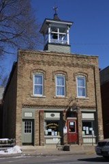 Brandon Village Hall and Librarylisted 2008
Population over time
2 figuresBrandon grew from 879 to 882 between 2010 and 2020. These are the recorded population figures Wikidata holds for this place, reached through the Geographic Names Information System number this page is keyed on rather than by name, so they belong to this place and not to another of the same name. Most are census counts, but not all are: an early figure may be a founding or settlement estimate, and an estimate published within five years of a census is left out. The change column is computed, and is left blank where more than 20 years separate a figure from the one before it, because a gap that long is not a change between two counts.
| Year | People | Change |
|---|---|---|
| 2010 | 879 | |
| 2020 | 882 | +3 (+0%) |
Topographic sheets covering this place
5 surveys from 8 printed sheetsMatched by testing this settlement's coordinate against the published boundary of every sheet in the United States Geological Survey's historical collection. Each opens the scanned sheet at the Survey.
- 1955 USGS Fox Lake quadrangle1:62500
- 1957 USGS Madison quadrangle1:250000, 3 printings
- 1960 USGS Madison quadrangle1:250000, 2 printings
- 1980 USGS Brandon quadrangle1:24000
- 1980 USGS Fond Du Lac quadrangle1:100000



In the county-history sources
4,652 words on this townshipThe History of Fond Du Lac County, Wisconsin, published 1880 names this settlement in its chapter on Brandon Village. These are the passages that mention it, exactly as the scans read.
This prosperous village lies in the southeastern part of Metomen. The first building within present corporation limits was built by R. W. Pride, in 1849, and stood on the site of F. M. Hillman's residence. The place was not improved nor continuously occupied for several years.
Passage source: The History of Fond Du Lac County, Wisconsin, published 1880.
It did not become a center of business until the completion of the railroad in 1856, when it began rapid strides toward the dignity of a city. In its early history, it was a lively place and known as " Bungtown." The station and village was named '- Brandon" by William Lockin, in honor of many Vermont settlers. It was not organized as a village until January 8, 1878. The first Trustees were, J. Abercrorabie, W. D. Ash, J. Lockin, L. Marsh, Gr. H. Paine and J. Raube. First President, William Plocker, and Clerk, Charles Heuman. The present officers are. President, G. A. Russell, and Clerk, E. Ensign.
Passage source: The History of Fond Du Lac County, Wisconsin, published 1880.
A Methodist class was formed as early as 1848, by Rev. H. Allen, a lay preacher and farmer, in the north part of Metomen. Meetings were held at Union Prairie Schoolhouse, wliich was one of a circuit containing three charges. This society in 1861 removed to Brandon, which by its rapid growth had become of central importance. The first official record of the Brandon Methodist Episcopal Church, is that of a quarterly conference held on Round Prairie, November 24, 1855, Rev. J. M. Walker, Presiding Elder, and Rev. John B. Armatage, preacher in charge. Services were held in private houses or schoolhouses, or sometimes in the hall of the building now kept as a hotel by Warren Hall. The present church was built in 1863, during the pastorate of Rev. Henry Requa. The present Board of Trustees are F. M. Hillman, F. P. Furguson, T. R. Darrow, William Bronson, G. A. Russell, C. P. Knapp and A. G. Yorty ; Clerk is W. R. Brown; Superintendent of Sunday school is Leander Ferguson; Rev. Jesse Cole is present Pastor. The total membership is 153. They have a commodious church and a comfortable parsonage. The society is an active force, and numerically exceeds any other religious association in the town. The Methodist Episcopal Church at Reed's Corners is also connected with this charge.
Passage source: The History of Fond Du Lac County, Wisconsin, published 1880.
Machine-read from a century-old scan, so expect the errors a machine makes: misspelled names, dropped words, stray characters.
Read the whole chapter on Brandon Village - it names this place 22 more 22 times.
Fires near this place
2 since 1998Regional context, not property-specific evidence. The federal wildfire occurrence database lists 2 fires within 5 miles of Brandon between 1998 and 2014, burning about 1,459 acres in total. None started naturally. None was recorded as arson. Distance is straight-line from the map coordinates, so a fire counted here may appear on a neighbouring settlement's page as well.
| Reported cause | Fires |
|---|---|
| Debris and open burning | 1 |
| Equipment and vehicle use | 1 |
The most recent of them, most recent first, with the day each was reported and the service that recorded it.
| Date | Cause | Size | Reported by | Name on the report |
|---|---|---|---|---|
| 11 April 2014 | Debris and open burning | 829 acres | Wisconsin Department of Natural Resources | DODGEVILLE CO-OP 5 |
| 24 October 1998 | Equipment and vehicle use | 630 acres | Wisconsin Department of Natural Resources | not named |
Settlements close enough to share some of these fires:
Mines and quarries near this place
4 within 5 milesRegional context, not property-specific evidence. The federal mineral resources record lists 4 workings within 5 miles of Brandon: 4 past producers. None of them still produces. What was taken out: Sand and Gravel, Construction, Limestone, Dimension, Stone, Crushed/Broken. Distance is straight-line from the map coordinates, so a quarry counted here may appear on a neighbouring settlement's page as well.
| Where | Site | Commodity | Status | Recorded |
|---|---|---|---|---|
| Leahman Quarry | Stone, Crushed/Broken | Past Producer | ||
| Waupun Stone Quarry | Limestone, Dimension | Past Producer | ||
| Bronson Pit | Sand and Gravel, Construction | Past Producer | ||
| Silverthorn Pit | Sand and Gravel, Construction | Past Producer |
Storms near this place
18 since 1994Regional context, not property-specific evidence. The National Weather Service names Brandon in 18 storm reports between 1994 and 2025: 12 thunderstorm wind, 3 hail, 2 tornado, 1 lightning. No death or injury is recorded in these reports. Each account below is quoted exactly as the forecast office filed it, from the NOAA Storm Events Database, and each date opens the federal record of that event.
| When | Event | Place named | Harm | What the report says |
|---|---|---|---|---|
| August 2018 | Thunderstorm Wind | Brandon | $7,600,000 | A swath of widespread tree and crop damage across the southern portion of the county. Sections of trees and crops completely flattened. Various roads closed due to fallen trees. The widespread wind damage and tornadoes caused structural damage to hundreds of homes, with affected damage to 200 homes, minor damage to 100 homes, major damage to 10 homes, and one home destroyed. One business sustained minor damage. |
| May 2016 | Tornado (EF1) | Brandon | $100,000 | An EF-1 tornado damaged the roofs of approximately 10 homes, 2 businesses, and 1 church. The roof damage covered less than 20 percent of the roof in most cases. The damage ranged from the removal of shingles to the entire removal of the roof material. Awnings and gutters were also damaged on the structures including a small number of windows. Numerous tree limbs were downed including some trees snapped at the base of the trunk, and approximately one tree uprooted. One large 20 foot trailer was overturned by the tornadic winds. |
| May 2007 | Lightning | Brandon | $100,000 | Lightning struck an older home that was subsequently destroyed by a fire. No one was at home at that time. |
| August 2000 | Thunderstorm Wind | Brandon | $15,000 | no account filed |
| June 2017 | Thunderstorm Wind | Brandon | $5,000 | Tree branches and trees down. |
| July 2017 | Thunderstorm Wind | Brandon | $5,000 | Trees down in yard with one landing on the home. |
| July 2008 | Thunderstorm Wind | Brandon | $5,000 | Powerful thunderstorm wind gusts toppled several large trees and broke branches that brought down some power-lines. |
| July 2005 | Thunderstorm Wind | Brandon | $5,000 | no account filed |
| June 2025 | Thunderstorm Wind | Brandon | $4,000 | Multiple large branches and trees down. |
| August 2019 | Thunderstorm Wind | Brandon | $2,000 | Several trees and power lines down. |
| August 2018 | Thunderstorm Wind | Brandon | $2,000 | Several large trees down. |
| July 2011 | Thunderstorm Wind | Brandon | $2,000 | Law enforcement officials reported damage to a building in Brandon. The severe thunderstorm gusts blew pieces of sheet metal from the building into the air. |
| June 2017 | Thunderstorm Wind | Brandon | $1,000 | A tree down on power lines. |
| July 2017 | Hail | Brandon | - | Estimated wind gusts of 50 mph with 3/4 inch hail. |
| September 2002 | Tornado (F0) | Brandon | - | A brief tornado spun up just north-northwest of the village of Brandon, as a cluster of severe storms moved east across Fond du Lac County. Law enforcement officials observed some tree damage. |
| July 1994 | Hail | Brandon | - | Isolated severe thunderstorms produced damaging winds affecting trees and power lines and dropped hail up to 1.5 inches in diameter over southwest and east-central Wisconsin. |
| June 2003 | Thunderstorm Wind | Brandon | - | no account filed |
| April 1999 | Hail | Brandon | - | no account filed |
Nearest settlements
The eight closest, with where each one stands in the county. Distances are straight-line, computed from the Geographic Names Information System coordinates.
| Map | Place | Distance | Sheets |
|---|---|---|---|
| Alto | 4.1 miles | 8 | |
| Fairwater | 4.6 miles | 8 | |
| Ladoga | 5.8 miles | 10 | |
| West Rosendale | 6.7 miles | 9 | |
| Rosendale | 7.5 miles | 9 | |
| Waupun | 7.5 miles | 10 | |
| Ripon | 7.9 miles | 10 | |
| Rogersville | 7.9 miles | 10 |
Elsewhere
Matched on this settlement's Geographic Names Information System number rather than its name, so it cannot be a different place of the same name in another state.
| Wikipedia article on Brandon | An encyclopaedic summary. Its text is share-alike, so it is linked here rather than copied. |
| Wikidata item Q1910390 | The structured record the population and elevation above come from. Public domain (CC0). |
Provenance
This settlement is recorded in the Geographic Names Information System as feature 1562145. The sheet list is computed by point-in-boundary test against the United States Geological Survey's historical topographic inventory. Both are works of the United States government and carry no copyright under 17 U.S.C. 105.
Wildfire. Short, Karen C. 2022. Spatial wildfire occurrence data for the United States, 1992-2020 [FPA_FOD_20221014]. 6th Edition. Fort Collins, CO: Forest Service Research Data Archive. https://doi.org/10.2737/RDS-2013-0009.6 Collected with United States Government funding and usable without additional permissions or fees.
Mines and quarries. USGS Mineral Resources Data System (MRDS) https://mrdata.usgs.gov/mrds/ A work of the United States government, no copyright under 17 U.S.C. 105.
Storms. NOAA National Centers for Environmental Information, Storm Events Database https://www.ncei.noaa.gov/stormevents/ A work of the United States government, no copyright under 17 U.S.C. 105. Narratives are quoted verbatim from the National Weather Service report and are not edited or summarised.