 Block
Raysville, Indiana
9 topographic sheets cover this place, the earliest surveyed in 1953 and the latest in 1986. It stands in Wayne Township. It lies in ZIP code area 46148. It stands on Buck Creek. The Survey maps it on the Knightstown quadrangle. It stands 919 feet above sea level.
On record in Raysville
Buildings and businesses the archive holds for this place. Each opens its own page, with the source record it came from.
On the National Register within a mile 3 records
The National Register names another town for these. They stand within one mile of this settlement's coordinate.
 Knightstown AcademyNational Historic Landmark · listed 1976 · 0.7 miles away
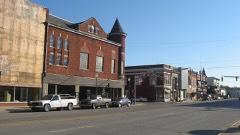 Knightstown Historic Districtlisted 1986 · 0.8 miles away
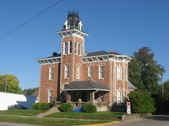 Elias Hinshaw Houselisted 1984 · 0.8 miles away
Topographic sheets covering this place
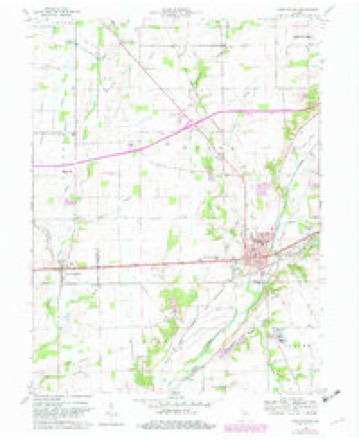
4 surveys from 9 printed sheetsMatched by testing this settlement's coordinate against the published boundary of every sheet in the United States Geological Survey's historical collection. Each opens the scanned sheet at the Survey.
- 1953 USGS Cincinnati quadrangle1:250000, 3 printings
- 1957 USGS Cincinnati quadrangle1:250000
- 1960 USGS Knightstown quadrangle1:24000, 3 printings
- 1986 USGS New Castle quadrangle1:100000, 2 printings



In the county-history sources
22,216 words on this townshipHistory of Henry County, Indiana : Together with Sketches of Its Cities, Villages, and Towns ... Also a Condensed History of Indiana, Embracing Accounts of Pre-historic Races, Aborigines, Winnebago and Black Hawk Wars, and a Brief Review of Its Civil and Political History., published 1884 names this settlement in its chapter on Wayne Township. These are the passages that mention it, exactly as the scans read.
Wayne Township, forming the southwestern corner of Henry County, has an undulating surface, good soil and excellent farming lands. It was settled early 'and has been steadily progressive and prosperous. It contains the wealthy town of Knightstown, and other villages of less importance which are mentioned hereafter. It is watered by Blue River, Montgomery Creek, Buck Creek and Six-Mile Creek.
Passage source: History of Henry County, Indiana : Together with Sketches of Its Cities, Villages, and Towns ... Also a Condensed History of Indiana, Embracing Accounts of Pre-historic Races, Aborigines, Winnebago and Black Hawk Wars, and a Brief Review of Its Civil and Political History., published 1884.
In 1825 the commissioners directed that elections for Wayne Township be held in future at the house of Prudence Jackson. In November, 1827, the place of election was changed from Mrs. Jackson's to Solomon Byrkett's; J^cpb Parkhurst's house, Raysville, and then Knightstown became successively the election place of the township. The township officers in 1822 were: Elijah Mc- Cray, E. Hardin and Daniel Priddy, Constables; Ebenezer Goble and Samuel Furgason, Overseers of the Poor; Daniel Heaton, Shaphet McCray and Jacob Parkhurst, Fence Miewers.
Passage source: History of Henry County, Indiana : Together with Sketches of Its Cities, Villages, and Towns ... Also a Condensed History of Indiana, Embracing Accounts of Pre-historic Races, Aborigines, Winnebago and Black Hawk Wars, and a Brief Review of Its Civil and Political History., published 1884.
For a few years West Liberty grew and prospered. At one time it had sixteen or more houses and several stores and taverns. The location of the National road north of the village in 1827 caused the incipient town to decline, and at last to fall, no more to fiourish.
Passage source: History of Henry County, Indiana : Together with Sketches of Its Cities, Villages, and Towns ... Also a Condensed History of Indiana, Embracing Accounts of Pre-historic Races, Aborigines, Winnebago and Black Hawk Wars, and a Brief Review of Its Civil and Political History., published 1884.
Machine-read from a century-old scan, so expect the errors a machine makes: misspelled names, dropped words, stray characters.
Read the whole chapter on Wayne Township - it names this place 4 more 4 times.
Mines and quarries near this place
1 within 5 milesRegional context, not property-specific evidence. The federal mineral resources record lists 1 working within 5 miles of Raysville: 1 past producer. None of them still produces. What was taken out: Sand and Gravel, Construction. Distance is straight-line from the map coordinates, so a quarry counted here may appear on a neighbouring settlement's page as well.
| Where | Site | Commodity | Status | Recorded |
|---|---|---|---|---|
| Omar V. Davis Pit | Sand and Gravel, Construction | Past Producer |
Storms near this place
2 since 2007Regional context, not property-specific evidence. The National Weather Service names Raysville in 2 storm reports between 2007 and 2012: 2 thunderstorm wind. No death or injury is recorded in these reports. Each account below is quoted exactly as the forecast office filed it, from the NOAA Storm Events Database, and each date opens the federal record of that event.
| When | Event | Place named | Harm | What the report says |
|---|---|---|---|---|
| June 2012 | Thunderstorm Wind | Raysville | $10,000 | A barn was blown over in this location due to damaging thunderstorm wind gusts. The time this event occurred was estimated based on radar data. |
| June 2007 | Thunderstorm Wind | Raysville | - | A few trees were reported down due to damaging thunderstorm winds. |
Nearest settlements
The eight closest, with where each one stands in the county. Distances are straight-line, computed from the Geographic Names Information System coordinates.
| Map | Place | Distance | Sheets |
|---|---|---|---|
| Knightstown | 0.7 miles | 9 | |
| Ogden | 2.3 miles | 10 | |
| Knox | 2.4 miles | 9 | |
| Stone Quarry Mills | 3.8 miles | 10 | |
| Dunreith | 3.9 miles | 10 | |
| Spiceland | 4.9 miles | 10 | |
| Grant City | 5.1 miles | 9 | |
| Greensboro | 6.0 miles | 11 |
Elsewhere
Matched on this settlement's Geographic Names Information System number rather than its name, so it cannot be a different place of the same name in another state.
| Wikipedia article on Raysville | An encyclopaedic summary. Its text is share-alike, so it is linked here rather than copied. |
| Wikidata item Q7299387 | The structured record the population and elevation above come from. Public domain (CC0). |
Provenance
This settlement is recorded in the Geographic Names Information System as feature 441802. The sheet list is computed by point-in-boundary test against the United States Geological Survey's historical topographic inventory. Both are works of the United States government and carry no copyright under 17 U.S.C. 105.
Mines and quarries. USGS Mineral Resources Data System (MRDS) https://mrdata.usgs.gov/mrds/ A work of the United States government, no copyright under 17 U.S.C. 105.
Storms. NOAA National Centers for Environmental Information, Storm Events Database https://www.ncei.noaa.gov/stormevents/ A work of the United States government, no copyright under 17 U.S.C. 105. Narratives are quoted verbatim from the National Weather Service report and are not edited or summarised.