 Block
Knightstown, Indiana
9 topographic sheets cover this place, the earliest surveyed in 1953 and the latest in 1986. It stands in Wayne Township. It lies in ZIP code area 46148. It stands on Glen Run. The Survey maps it on the Knightstown quadrangle. 2,140 people lived here at the 2020 count. It stands 932 feet above sea level.
On record in Knightstown
Buildings and businesses the archive holds for this place. Each opens its own page, with the source record it came from.
On the National Register 4 records
 Knightstown AcademyNational Historic Landmark · listed 1976
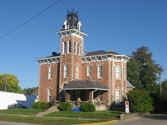 Elias Hinshaw Houselisted 1984
 Knightstown Historic Districtlisted 1986
- Knightstown, Old, and Glen Cove Cemeterieslisted 2019
Population over time
2 figuresKnightstown fell from 2,182 to 2,140 between 2010 and 2020. These are the recorded population figures Wikidata holds for this place, reached through the Geographic Names Information System number this page is keyed on rather than by name, so they belong to this place and not to another of the same name. Most are census counts, but not all are: an early figure may be a founding or settlement estimate, and an estimate published within five years of a census is left out. The change column is computed, and is left blank where more than 20 years separate a figure from the one before it, because a gap that long is not a change between two counts.
| Year | People | Change |
|---|---|---|
| 2010 | 2,182 | |
| 2020 | 2,140 | -42 (-2%) |
Topographic sheets covering this place
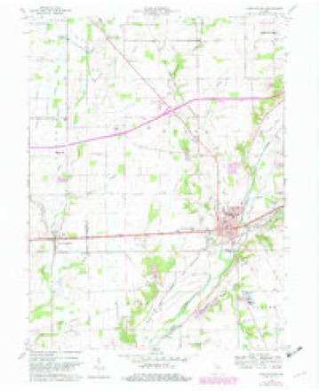
4 surveys from 9 printed sheetsMatched by testing this settlement's coordinate against the published boundary of every sheet in the United States Geological Survey's historical collection. Each opens the scanned sheet at the Survey.
- 1953 USGS Cincinnati quadrangle1:250000, 3 printings
- 1957 USGS Cincinnati quadrangle1:250000
- 1960 USGS Knightstown quadrangle1:24000, 3 printings
- 1986 USGS New Castle quadrangle1:100000, 2 printings



In the county-history sources
22,216 words on this townshipHistory of Henry County, Indiana : Together with Sketches of Its Cities, Villages, and Towns ... Also a Condensed History of Indiana, Embracing Accounts of Pre-historic Races, Aborigines, Winnebago and Black Hawk Wars, and a Brief Review of Its Civil and Political History., published 1884 names this settlement in its chapter on Wayne Township. These are the passages that mention it, exactly as the scans read.
Wayne Township, forming the southwestern corner of Henry County, has an undulating surface, good soil and excellent farming lands. It was settled early 'and has been steadily progressive and prosperous. It contains the wealthy town of Knightstown, and other villages of less importance which are mentioned hereafter. It is watered by Blue River, Montgomery Creek, Buck Creek and Six-Mile Creek.
Passage source: History of Henry County, Indiana : Together with Sketches of Its Cities, Villages, and Towns ... Also a Condensed History of Indiana, Embracing Accounts of Pre-historic Races, Aborigines, Winnebago and Black Hawk Wars, and a Brief Review of Its Civil and Political History., published 1884.
On the farm of J. F. Saddler, two miles west of Knightstown, may be found a herd of five head of Hereford cattle, thoroughbred and pedigreed. They were imported in 1882 from England by Mr. Saddler. He, in partnership with J. F. Bell, is the owner of the above stock. The firm have now twenty head of full-blooded Herefords and twenty-five head of Shorthorns, which they are breeding with them. The Green Mound stock farm of E. E. Elliott is the abode of the well-bred and pedigreed horse Tom Walker, of which Mr. Elliott is the owner, together with other fine stock. The people of this vicinity are fully awake to the importance of fine stock, and there is steady progress in the improvement of every kind of live stock.
Passage source: History of Henry County, Indiana : Together with Sketches of Its Cities, Villages, and Towns ... Also a Condensed History of Indiana, Embracing Accounts of Pre-historic Races, Aborigines, Winnebago and Black Hawk Wars, and a Brief Review of Its Civil and Political History., published 1884.
Among the early residents of the village were Judge Anderson, Elijah Knight and John Death. The two last named were tavernkeepers, and their houses were situated on opposite sides of the street. Travelers were wont to look at the signs, and say: Knight on one side, Death on the other," and pass on. Isaac Scott was another early settler who kept tavern several years. Joel Pusey, Caleb White and Robert Wilson were early merchants.
Passage source: History of Henry County, Indiana : Together with Sketches of Its Cities, Villages, and Towns ... Also a Condensed History of Indiana, Embracing Accounts of Pre-historic Races, Aborigines, Winnebago and Black Hawk Wars, and a Brief Review of Its Civil and Political History., published 1884.
Machine-read from a century-old scan, so expect the errors a machine makes: misspelled names, dropped words, stray characters.
Read the whole chapter on Wayne Township - it names this place 69 more 69 times.
Mines and quarries near this place
1 within 5 milesRegional context, not property-specific evidence. The federal mineral resources record lists 1 working within 5 miles of Knightstown: 1 past producer. None of them still produces. What was taken out: Sand and Gravel, Construction. Distance is straight-line from the map coordinates, so a quarry counted here may appear on a neighbouring settlement's page as well.
| Where | Site | Commodity | Status | Recorded |
|---|---|---|---|---|
| Omar V. Davis Pit | Sand and Gravel, Construction | Past Producer |
Storms near this place
15 since 1994Regional context, not property-specific evidence. The National Weather Service names Knightstown in 15 storm reports between 1994 and 2025: 11 thunderstorm wind, 3 hail, 1 flash flood. No death or injury is recorded in these reports. Each account below is quoted exactly as the forecast office filed it, from the NOAA Storm Events Database, and each date opens the federal record of that event.
| When | Event | Place named | Harm | What the report says |
|---|---|---|---|---|
| April 2025 | Flash Flood | Knightstown | $50,000 | Numerous roads closed across the county due to heavy rains. Culverts were washed out. Total rainfall ranged from 2.6 to 3.1 inches. |
| May 2008 | Thunderstorm Wind | Knightstown | $20,000 | Two trucks, a trailer, camper, and a Bobcat were damaged from thunderstorm winds that moved through Knightstown. |
| June 2007 | Thunderstorm Wind | Knightstown | $12,000 | Law enforcement reported a roof of a house was damaged at 625 W and U.S. 40. Also, trees were blown down onto a house near Raysville. |
| April 2020 | Thunderstorm Wind | Knightstown | $10,000 | Picture received of uprooted tree that had fallen on a car due to thunderstorm wind gusts. Relayed via twitter. |
| May 2008 | Thunderstorm Wind | Knightstown | $5,000 | A house sustained damage due to damaging thunderstorm winds. Six to seven inch tree limbs were down and there was no power in town due to the storm. |
| May 2011 | Thunderstorm Wind | Knightstown | $3,000 | An eight inch diameter tree branch was reported down on a car due to damaging thunderstorm wind gusts. |
| June 2016 | Thunderstorm Wind | Knightstown | $1,000 | A fence was blown down due to damaging thunderstorm wind gusts. Large tree limbs were also downed. |
| May 2011 | Thunderstorm Wind | Knightstown | - | A 60 mph thunderstorm wind gust was reported in this location. |
| July 2006 | Hail | Knightstown | - | No property damage reported. |
| April 1994 | Thunderstorm Wind | Knightstown | - | A thunderstorm blew a tree down onto a house, barn, and garage in Knightstown. A large commercial-use garage was demolished by straight line winds. |
| May 2011 | Hail | Knightstown | - | no account filed |
| May 2008 | Thunderstorm Wind | Knightstown | - | no account filed |
| July 2006 | Hail | Knightstown | - | no account filed |
| May 2003 | Thunderstorm Wind | Knightstown | - | no account filed |
| June 2001 | Thunderstorm Wind | Knightstown | - | no account filed |
Nearest settlements
The eight closest, with where each one stands in the county. Distances are straight-line, computed from the Geographic Names Information System coordinates.
| Map | Place | Distance | Sheets |
|---|---|---|---|
| Raysville | 0.7 miles | 9 | |
| Knox | 2.1 miles | 9 | |
| Ogden | 3.1 miles | 10 | |
| Stone Quarry Mills | 4.2 miles | 10 | |
| Dunreith | 4.7 miles | 10 | |
| Grant City | 5.0 miles | 9 | |
| Spiceland | 5.5 miles | 10 | |
| Maple Valley | 5.9 miles | 9 |
Elsewhere
Matched on this settlement's Geographic Names Information System number rather than its name, so it cannot be a different place of the same name in another state.
| Wikipedia article on Knightstown | An encyclopaedic summary. Its text is share-alike, so it is linked here rather than copied. |
| Wikidata item Q2285705 | The structured record the population and elevation above come from. Public domain (CC0). |
Provenance
This settlement is recorded in the Geographic Names Information System as feature 437394. The sheet list is computed by point-in-boundary test against the United States Geological Survey's historical topographic inventory. Both are works of the United States government and carry no copyright under 17 U.S.C. 105.
Mines and quarries. USGS Mineral Resources Data System (MRDS) https://mrdata.usgs.gov/mrds/ A work of the United States government, no copyright under 17 U.S.C. 105.
Storms. NOAA National Centers for Environmental Information, Storm Events Database https://www.ncei.noaa.gov/stormevents/ A work of the United States government, no copyright under 17 U.S.C. 105. Narratives are quoted verbatim from the National Weather Service report and are not edited or summarised.