 Block
From the record
12 National Register listings published here · the county-history sources tell 2 stories.
Sources: the county history on the Internet Archive · the National Register database, National Park Service
31 topographic sheets cover 14 settlements here, and 12 properties are on the National Register of Historic Places.
12 National Register listings published here · the county-history sources tell 2 stories.
Sources: the county history on the Internet Archive · the National Register database, National Park Service
Among them: The Colorado Beetle; Narrow Escape From Death. These passages come from the identified county-history source books. Each inset names its own source and opens the exact section it comes from.
Potato bugs were then new to the people of this country. Very few people had ever seen one prior to 1865. This year, (1868) the Mankato Record (now Review) remarked that "those striped bugs which, for the past three years have so seriously damaged the crop west of us, have already made their appear- ance in large numbers." Other papers noticed their appearance, and our paper remarlied that "we have not heard of any of these pests in this immediate vicinity, but doubt not tliey will soon visit this section." We remarked that they should be "attacked at first sight and exterminated if possible." As M'e soon after learned, this was more easily said tlian done.
Here is an item that appeared Nov. 25, 1868: "Venison is beginning to find its way into our market. Several deer have been shot in this section within the past few days. Some of our sportsmen killed one in the timber bordering on Clear lake, a few days ago." No live wild deer have ever been seen in this section since.
Every property in this county listed on the National Register of Historic Places, with the year it was listed and the federal nomination document.
| Photograph | Property | Type | Listed | Reference |
|---|---|---|---|---|
 | W. J. Armstrong Company Wholesale Grocers | building | 1982 | 82003067 |
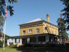 | John W. Aughenbaugh House | building | 1982 | 82003068 |
| Philo C. Bailey House | building | 1994 | 94001384 | |
 | Hoffman Apiaries | building | 2016 | 15000982 |
 | Janesville Free Public Library | building | 1982 | 82003065 |
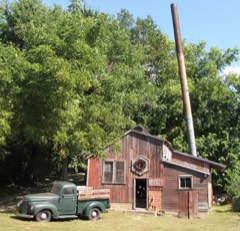 | Seha Sorghum Mill | building | 1979 | 79003718 |
| Strangers Refuge Lodge Number 74, IOOF | building | 2006 | 06000601 | |
| Vista Lutheran Church | building | 1982 | 82000565 | |
 | Roscoe P. Ward House | building | 1982 | 82003069 |
| Waseca Commercial Historic District | district | 2020 | 100004864 | |
| Waseca County Courthouse | building | 1982 | 82003070 | |
 | William R. Wolf House | building | 1982 | 82003071 |
Every wildfire the federal occurrence database records inside this county: 8 of them, burning about 64 acres. None started naturally and 7 were recorded as arson. Each settlement page carries the fires within five miles of it.
| Reported cause | Fires |
|---|---|
| Arson/incendiarism | 7 |
| Missing data/not specified/undetermined | 1 |
The five largest, by the area the report gives. 7 of them were set deliberately.
| Date | Cause | Size | Reported by | Name on the report |
|---|---|---|---|---|
| 10 November 2012 | Arson/incendiarism | 50 acres | Minnesota Department of Natural Resources | not named |
| 8 October 2012 | Missing data/not specified/undetermined | 9.0 acres | Minnesota Department of Natural Resources | not named |
| 31 October 2006 | Arson/incendiarism | 2.8 acres | Minnesota Department of Natural Resources | not named |
| 30 October 2006 | Arson/incendiarism | 1.2 acres | Minnesota Department of Natural Resources | not named |
| 1 August 2020 | Arson/incendiarism | 1.0 acres | Minnesota Valley National Wildlife Refuge | FELBER |
| 9 November 2006 | Arson/incendiarism | under an acre | Minnesota Department of Natural Resources | not named |
| 30 October 2006 | Arson/incendiarism | under an acre | Minnesota Department of Natural Resources | not named |
| 2 November 2006 | Arson/incendiarism | under an acre | Minnesota Department of Natural Resources | not named |
Every settlement page carries the fires within five miles of it - see the settlement index below.
The NOAA Storm Events Database holds 314 reports for this county, causing 6 deaths, 25 injuries and about $84,817,500 in recorded property damage. Each settlement page carries the reports that name it.
| Kind of event | Reports |
|---|---|
| Thunderstorm Wind | 120 |
| Hail | 114 |
| Tornado | 28 |
| Flash Flood | 18 |
| Heavy Rain | 14 |
| Funnel Cloud | 10 |
| Flood | 8 |
| Lightning | 2 |
The most serious of them, by death, then injury, then recorded damage. The accounts are quoted exactly as the forecast office filed them.
| When | Event | Place named | Harm | What the report says |
|---|---|---|---|---|
| April 1967 | Tornado (F4) | not stated | 6 killed, 22 hurt, $25,000,000 | no account filed |
| August 1978 | Tornado (F1) | not stated | 1 hurt, $2,500,000 | no account filed |
| May 1961 | Tornado (F2) | not stated | 1 hurt, $250,000 | no account filed |
| September 2018 | Tornado (EF1) | Smiths Mill | 1 hurt | A National Weather Service storm survey concluded that an EF1 tornado tracked 7.1 miles from near the Blue Earth, Waseca county line, northwest of Janesville, then over Lake Elysian, before lifting near the Le Sueur, Waseca county line. Tornado damage was consistent with EF1 damage with winds up to 105 mph, and a maximum path width of 440 yards. Shortly after touchdown, it hit a home and removed its roof and destroyed the garage. A man in the garage was blown into the yard and suffered a minor injury, but did not require hospitalization. Other damage was confined to trees, outbuildings, and homes. There was also isolated damage on the south side of the tornado track due to severe inflow. Damage was confined to large trees and outbuildings on east side of Lake Elysian. |
| April 1967 | Tornado (F3) | not stated | $25,000,000 | no account filed |
| April 1967 | Tornado (F2) | not stated | $25,000,000 | no account filed |
| May 1996 | Thunderstorm Wind | Waseca | $4,000,000 | no account filed |
| September 2010 | Flood | Waldorf | $1,000,000 | Numerous roads were closed due to excessive rainfall that fell on September 22nd and 23th. The major areal flooding didn't recede until late Saturday when most of the small streams and creeks had crested and only mainstem rivers remained flooded. In New Richland, Minnesota, Highway 30 and Highway 13 were closed, making it impossible for the roughly 1,000 residents to get out of town. |
| May 2022 | Thunderstorm Wind | Otisco | $250,000 | A large machine shed was blown apart and other outbuildings had some roof damage. Several dozen trees were also toppled as the downburst moved northeast through the small community of Otisco and then to a farm northeast of Otisco. |
| August 2010 | Thunderstorm Wind | Waldorf | $250,000 | Two large hog barns were blown down northeast of Waldorf, Minnesota. |
| June 1984 | Tornado (F1) | not stated | $250,000 | no account filed |
| June 1979 | Tornado (F1) | not stated | $250,000 | no account filed |
| April 1970 | Tornado (F2) | not stated | $250,000 | no account filed |
| June 1963 | Tornado (F2) | not stated | $250,000 | no account filed |
| June 2020 | Thunderstorm Wind | New Richland | $100,000 | A large church steeple was blown over, landing in the parking lot. |
| May 2014 | Thunderstorm Wind | Waseca | $100,000 | Many large trees and power poles were snapped off from south to north across the city of Waseca. Also, a large grain bin was destroyed north of Waseca. |
| March 2012 | Tornado (EF0) | Janesville | $100,000 | An EF-0 tornado touched down just south of Elysian Lake Road, just south of 412th Avenue, in northern Waseca County. The tornado tracked north for approximately 2.8 miles while paralleling the eastern shore of Elysian Lake and Elysian Lake Road. It crossed Elysian Lake near 427th Ave, before moving into southern Le Sueur County. ||Damage was primarily associated with uprooted trees and roof damage. The worst damage occurred to a farmstead which had a metal storage shed collapse along Elysian Lake Road. ||Based on trees uprooted and structural damage to a metal storage shed, winds were estimated around 80 mph. |
| April 2022 | Thunderstorm Wind | Waldorf | $50,000 | Reports of sporadic wind damage occurred from near the Waldorf area, northeast to rural areas of Janesville, hitting a few outbuildings. One broken power pole was reported north of Waseca. |
| August 2003 | Thunderstorm Wind | Janesville | $50,000 | Roof partially blown off home. Barn blown down. Numerous trees and large branches down. |
| June 1994 | Thunderstorm Wind | New Richland | $50,000 | High thunderstorm winds blew a roof off of a 376-foot hog confinement building just south of New Richland. |
| June 1983 | Tornado (F0) | not stated | $25,000 | no account filed |
| July 1973 | Tornado (F1) | not stated | $25,000 | no account filed |
| May 2024 | Thunderstorm Wind | Waldorf | $20,000 | A baseball field dugout was destroyed and a large tree was split. Large branches were also downed. Pictures were relayed via Slack. Time estimated by radar. |
| August 2019 | Thunderstorm Wind | Janesville | $15,000 | A large tree fell on a house in Janesville. |
| April 2022 | Thunderstorm Wind | Janesville | $10,000 | A farm outbuilding was damaged near Reeds Lake, or northeast of Janesville. In addition, a couple of trees were blown down. |
| December 2021 | Thunderstorm Wind | Janesville | $10,000 | Several trees and large branches were blown down between Janesville and Waseca, with a street light damaged, and a few metal sheds and trampolines thrown. |
| June 1994 | Thunderstorm Wind | Waldorf | $5,000 | A large tree was uprooted in a front yard of a home in the city of Waldorf. |
| June 1984 | Tornado (F1) | not stated | $2,500 | no account filed |
| July 1973 | Tornado (F0) | not stated | $2,500 | no account filed |
| June 1973 | Tornado (F0) | not stated | $2,500 | no account filed |
| July 2025 | Funnel Cloud | Alma City | - | Funnel cloud lasted for roughly 5 to 10 minutes and never reached the ground. |
| August 2025 | Heavy Rain | Waseca | - | A trained spotter reported 72 hour storm total of 9.83 inches of rain. |
| August 2025 | Flash Flood | Waseca | - | The city of Waseca received close to 9 inches of rain spanning from Saturday evening into Sunday morning. Several roads near and around the city of Waseca were closed due to water over the road, including a portion of 110th street stretching from 325th to 360th. Emergency manager reported that the city had to bypass the sanitary sewer and dump into the lake to save numerous homes. |
| August 2025 | Heavy Rain | Waseca Muni Arpt | - | CO-OP Observer station WASM5 Waseca. 72 hour total of 9.48 inches. |
| August 2025 | Heavy Rain | Janesville | - | Cocorahs station MN-WC-17 Janesville 3.0 S - 72 hour total of 7.62 inches. |
| August 2025 | Heavy Rain | Waseca | - | Cocorahs station MN-WC-12 Waseca 1.6 SSE. 72 hour total of 6.87 inches. |
| August 2025 | Heavy Rain | Waseca | - | Cocorahs station MN-WC-8 Waseca 2.0 N. 72 hour storm total of 5.28 inches. |
| September 2025 | Hail | Alma City | - | Report of hail covering the ground, with the largest stone being quarter-sized. Also tree branches down. |
| September 2025 | Hail | Otisco | - | Spotter measured hailstones of penny to quarter size. |
| June 2024 | Thunderstorm Wind | New Richland | - | Several trees were downed, including one across a railroad track. |
| August 2024 | Tornado (EF1) | Smiths Mill | - | After moving east-southeast in Blue Earth County, the tornado entered Waseca County and turned to the southeast. It mostly moved across fields but it did break or uproot dozens of trees. It flipped a tractor on its side. Toward the end of its path, the tornado blew in a garage door of an old barn. |
| August 2024 | Tornado (EF1) | Otisco | - | The tornado mostly moved across fields, but it did snap the trunks of multiple trees. Other trees were uprooted, with one falling on a power line. |
| August 2024 | Thunderstorm Wind | Waseca Muni Arpt | - | Photos submitted of damage of a destroyed grain bin and crop damage. |
| July 2024 | Thunderstorm Wind | Waseca | - | Six to eight trees down in the southeast bay of Watkins Lake. They were downed toward the west-northwest, which along with another report from the west side of Watkins Lake, is consistent with this having been due to a microburst. |
| July 2024 | Thunderstorm Wind | Waseca | - | About two dozen trees were downed on the west side of Watkins Lake. They were all knocked down toward the west-northwest. Trained spotters never reported a tornado with this highly visible storm. Discussion with local residents also took place and led to the conclusion that this was microburst damage. |
| June 2024 | Heavy Rain | Janesville | - | A total of 4 to 6 inches of rain fell from multiple rounds of thunderstorms. CoCoRaHS observers measured 6.45 inches near Elysian. |
| June 2024 | Thunderstorm Wind | New Richland | - | There were photos of large tree branches down across town and several trees snapped near their base. Some branches were down on homes and power lines were down. Time was estimated via radar. |
| June 2024 | Flash Flood | Janesville | - | Road closures were reported around the town of Janesville due to flooded roadways. |
| June 2024 | Flash Flood | Waseca | - | Road closures were reported south of Waseca due to flooded roadways. |
| June 2023 | Funnel Cloud | Janesville | - | A trained spotter reported that the funnel reached about halfway to the ground southwest of Janesville, MN. |
| May 2023 | Flash Flood | New Richland | - | Emergency Management in Waseca County reported that street and small stream flooding was occurring in and about three miles north of New Richland, MN. There were also reports of numerous structures and homes with flooded basements. Approximately two miles north of New Richland, a trained spotter reported that heavy rains were allowing Boot Creek to flow about six feet out of its banks and it started to run over 120th Street (Paved elevated road). Approximately three miles north of New Richland, MN, heavy rainfall caused flooding of a roadway which cut off access to a household's driveway. New Richland City Administration confirmed that flash flood waters receded within 24 hours and no longer posed a threat to public safety. |
| July 2023 | Thunderstorm Wind | Janesville | - | Strong thunderstorm winds brought down a 10-inch diameter tree limb which blocked a roadway in Janesville, MN. |
| May 2022 | Heavy Rain | Waseca | - | Rainfall was measured at 3.20 inches. |
| April 2022 | Thunderstorm Wind | Otisco | - | Half of the shingles were blown off a house. |
| June 2022 | Heavy Rain | Waseca | - | This was a measured rainfall report of 2.80 inches of rain in less than three hours. |
| August 2021 | Tornado (EF0) | New Richland | - | A damage survey noted several trees were damaged at a farmstead, with large branches down. Satellite imagery showed more details to the tornado path. A time-stamped photo from a storm chaser showed a visible funnel in the area where the tornado damage occurred, and the photo was consistent with the tornado being in the flanking line. |
| August 2021 | Tornado (EF0) | New Richland | - | Radar shows this tornado occurred with a flanking line, just south of precipitation echoes. A damage survey revealed mostly corn damage, but some large branches were knocked down at a farmstead and some plywood was blown into a field. The damage survey revealed it was tornadic. Satellite imagery revealed more detail about the exact path through fields. Storm chaser video definitely shows the tornado and correct time, which was consistent with this being a tornado from a flanking line. |
| June 2020 | Thunderstorm Wind | Waldorf | - | This was a measured wind gust from a storm chaser's wind sensor equipment. |
| June 2020 | Thunderstorm Wind | New Richland | - | A large tree was blown down at the intersection of 105th and 120th streets. |
| September 2020 | Thunderstorm Wind | Janesville | - | There was a picture of a large tree blown down in Janesville. |
The Survey's mineral resources record lists 3 workings inside this county. All of them still produce. Each settlement page carries the workings within five miles of it.
| Commodity | Workings |
|---|---|
| Sand and Gravel, Construction | 3 |
The least common of them first, because a county's hundredth gravel pit says nothing its first ten did not.
| Where | Site | Commodity | Status | Recorded |
|---|---|---|---|---|
| Bauman Pit & Mill | Sand and Gravel, Construction | Producer | ||
| Harguth Pit | Sand and Gravel, Construction | Producer | ||
| Schmidt Pit | Sand and Gravel, Construction | Producer |
Child's History of Waseca County, Minnesota : from Its First Settlement in 1854 to the Close of the Year 1904, a Record of Fifty Years : the Story of the Pioneers devotes a chapter to each township: its boundaries and streams, who settled it and when, the mills, the schools and the churches. All 9 are reproduced here in full. Each row shows the township's own shape and where it lies in the county, drawn from the Census Bureau's boundary. Which settlements belong to which township is computed from that same boundary, not taken from the book.
| Shape and position in the county | Township | Settlements in it | Length | Sections |
|---|---|---|---|---|
| Alton Township | Alma City | 9,065 words | 3 | |
| Byron Township | Matawan | 256 words | 0 | |
| Iosco Township | Palmer | 6,370 words | 5 | |
| Janesville Township | Janesville, Lake Elysian, Smiths Mill | 970 words | 0 | |
| New Richland City | New Richland | 122 words | 0 | |
| Otisco Township | Otisco, Vista | 3,598 words | 1 | |
| St. Mary Township | Saint Mary | 1,206 words | 1 | |
| Waseca City | Colony Court, Waseca | 35,970 words | 36 | |
| Wilton Township | Wilton | 1,269 words | 0 |
2 books written about this county, cut here where the book itself is cut, at its printed chapters: 90 chapters in all. Every chapter is public domain, machine-read from the scan and reproduced complete. A chapter already given under one of the county's towns is not repeated in this list.
| Chapter | Length |
|---|---|
| Chapter 4: Organization, County Lines, and Coltnty Name | 2,086 words |
| Chapter 3: Eaely Settlement | 5,935 words |
| Chapter 4: Eeminiscences and Incidents | 5,809 words |
| Chapter 6: Political | 2,292 words |
| Chapter with an unread heading (no. 33 of those read) | 12,942 words |
| Chapter 9: County-Seat Contests and County Buildings | 2,144 words |
| Chapter 10: Journalism | 5,009 words |
| Chapter 11: Bench and Bar | 3,754 words |
| Chapter 12: Educational | 1,534 words |
| Chapter 13: Agkiculture and Agricultueal Societies | 2,589 words |
| Chapter 14: Waseca Couxty in the War | 439 words |
| Chapter 16: Wilton Township | 6,155 words |
| Chapter 17: St. Maey Township | 5,838 words |
| Chapter 19: Liloominu (4 Move Township | 8,349 words |
| Chapter 20: Otisco Township | 8,325 words |
| Chapter 21: Janesville Township and Village | 10,743 words |
| Chapter 22: Wooda^lle Township | 4,871 words |
| Chapter 23: New Richland Township and Village | 13,736 words |
| Chapter 25: Btkon Township | 4,239 words |
| Chapter 27: Freedom Township | 6,008 words |
Named settlements recorded in the Geographic Names Information System, each with the topographic sheets covering it. Villages, hamlets and abandoned places alike. Each is shown with the nearest named watercourse or landform and the survey quadrangle it falls on.
Wilton township · 56093 · On Little Le Sueur River · Waseca quadrangle
11 sheets, 1953 to 1991