 Block
From the record
27 National Register listings published here.
Sources: the National Register database, National Park Service
67 topographic sheets cover 14 settlements here, and 27 properties are on the National Register of Historic Places.
27 National Register listings published here.
Sources: the National Register database, National Park Service
Every property in this county listed on the National Register of Historic Places, with the year it was listed and the federal nomination document.
| Photograph | Property | Type | Listed | Reference |
|---|---|---|---|---|
 | Mrs. Louis Bedell House | building | 1980 | 80002324 |
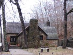 | Big Spring Historic District | district | 1981 | 81000101 |
| Earl Boyer House | building | 1980 | 80002325 | |
 | Carter County Courthouse | building | 2022 | 100008239 |
| J. W. Gibson House | building | 1980 | 80002326 | |
| Delia Greensfelder House | building | 1980 | 80002327 | |
| Loretta Herrington House | building | 1980 | 80002328 | |
| James Hinton House | building | 1980 | 80002329 | |
| Nettie Jacobson House | building | 1980 | 80002330 | |
| Nola Kitterman House | building | 1980 | 80002331 | |
| Wallace Knapp House | building | 1980 | 80002332 | |
| Buford Lawhorn House | building | 1980 | 80002333 | |
| Iva Lewis House | building | 1980 | 80002334 | |
| Masonic Lodge | building | 1980 | 80002335 | |
| Terry Mays House | building | 1980 | 80002336 | |
| Thornton McNew House | building | 1980 | 80002337 | |
| Mill Pond | site | 1980 | 80002338 | |
| Della Nance House | building | 1980 | 80002339 | |
 | Hazel Owens House | building | 1980 | 80002340 |
| Ernie Phillips House | building | 1980 | 80002341 | |
| Alvis Powers House | building | 1980 | 80002342 | |
| Hazel Shoat House | building | 1980 | 80002343 | |
| Sixth Street Historic District | district | 1980 | 80002344 | |
| James Smith House | building | 1980 | 80002345 | |
| Lawrence Smith House | building | 1980 | 80002346 | |
| William F. Smith House | building | 1980 | 80002347 | |
| Lee Tucker House | building | 1980 | 80002348 |
Every wildfire the federal occurrence database records inside this county: 340 of them, burning about 7,530 acres. 2 started naturally and 122 were recorded as arson. Each settlement page carries the fires within five miles of it.
| Reported cause | Fires |
|---|---|
| Debris and open burning | 123 |
| Arson/incendiarism | 122 |
| Missing data/not specified/undetermined | 53 |
| Equipment and vehicle use | 18 |
| Recreation and ceremony | 12 |
| Smoking | 6 |
| Power generation/transmission/distribution | 3 |
| Natural | 2 |
| Other causes | 1 |
The five largest, by the area the report gives. Four of them were set deliberately.
| Date | Cause | Size | Reported by | Name on the report |
|---|---|---|---|---|
| 23 March 2011 | Missing data/not specified/undetermined | 1,227 acres | Missouri Department of Conservation | HWY. 21 SOUTH |
| 7 April 1997 | Debris and open burning | 400 acres | Mark Twain National Forest | HILL TOP |
| 8 November 2010 | Missing data/not specified/undetermined | 388 acres | Missouri Department of Conservation | DEVIL'S RUN |
| 21 November 1993 | Arson/incendiarism | 150 acres | Ozark National Scenic River | HOOPER HOL |
| 12 April 2018 | Missing data/not specified/undetermined | 131 acres | Mark Twain National Forest | EASTWOOD |
| 22 November 1993 | Arson/incendiarism | 130 acres | Missouri Department of Conservation | not named |
| 25 March 1995 | Arson/incendiarism | 130 acres | Missouri Department of Conservation | not named |
| 28 March 2019 | Arson/incendiarism | 129 acres | Missouri Department of Conservation | 178397-00000-03282019-1600 |
Every settlement page carries the fires within five miles of it - see the settlement index below.
The NOAA Storm Events Database holds 269 reports for this county, causing 10 deaths, 91 injuries and about $39,587,600 in recorded property damage. Each settlement page carries the reports that name it.
| Kind of event | Reports |
|---|---|
| Hail | 94 |
| Thunderstorm Wind | 77 |
| Flash Flood | 30 |
| Flood | 30 |
| Tornado | 22 |
| Heavy Rain | 7 |
| Funnel Cloud | 6 |
| Lightning | 3 |
The most serious of them, by death, then injury, then recorded damage. The accounts are quoted exactly as the forecast office filed them.
| When | Event | Place named | Harm | What the report says |
|---|---|---|---|---|
| May 1957 | Tornado (F4) | not stated | 7 killed, 75 hurt, $250,000 | no account filed |
| June 2019 | Thunderstorm Wind | Van Buren | 1 killed, 2 hurt, $20,000 | Within the Ozark National Scenic Riverways, a tree fell on a boat on the Current River. The boat was traveling downstream in the vicinity of the Waymeyer Shute river access point. The 22-year-old male driver of the boat was killed, and two passengers in their 20's were moderately injured. The injured parties were from the local area and were treated at a local hospital. In the same general vicinity, trees and large tree limbs were down on the north end of M Highway. |
| December 1982 | Tornado (F2) | not stated | 1 killed, 1 hurt, $2,500,000 | no account filed |
| March 2006 | Flash Flood | Ellsinore | 1 killed, $25,000 | Flash flooding of Ten Mile Creek caused the death of a 57-year-old man. The man drowned when the flat bed truck he was driving was swept off the road as he was attempting to cross the creek. The incident occurred on a private gravel road off Highway B. The truck was swept downstream about 50 yards and overturned in the creek, resting upside down. The body was recovered still in the truck. The incident was estimated to have happened around 6 A.M. CST when he attempted to drive across the creek to a hog barn. |
| April 2004 | Tornado (F2) | Ellsinore | 5 hurt, $600,000 | The tornado touched down about one mile south of the intersection of U.S. Highway 60 and County Highway 233 in eastern Carter County. The tornado tracked north-northeast, passing only about a mile west of the town of Ellsinore. The tornado damage path ended on County Road 365 less than one half mile before reaching the Wayne County line. Peak winds in the tornado were estimated at 150 MPH. Most of the injured were in a mobile home on the north side of U.S. Highway 60. Their mobile home was picked up and thrown into some trees. One person was critically injured. The critically injured person was paralyzed when her back and neck was broken, and she was airlifted to a St. Louis area hospital. Another person received a broken arm, and most of the remaining injuries were scrapes and cuts. The tornado destroyed a total of three mobile homes, a storage facility, and numerous sheds. Two homes and one business were severely damaged. Numerous vehicles were damaged. |
| April 2002 | Tornado (F4) | Van Buren | 2 hurt, $15,000,000 | The tornado damage path began on the west side of Van Buren, right along the Current River, and crossed U.S. Route 60 very close to the Current River bridge. Two businesses in Van Buren, a lodge and a restaurant, were heavily damaged by F-2 intensity winds. The tornado travelled southeast across hilly and forested terrain until reaching the community of Ellsinore. Damage on the south side of Ellsinore was severe, where about 7 businesses were destroyed. Most of the damage at Ellsinore, which was inflicted by F-4 intensity winds, occurred along and near U.S. Highway 60. Across Carter County, 13 homes were destroyed and 12 homes suffered major damage. The tornado then moved into the Mark Twain National Forest and crossed into Butler County north of Highway 60. |
| December 1982 | Tornado (F1) | not stated | 2 hurt, $25,000 | no account filed |
| July 2021 | Lightning | Van Buren | 2 hurt | Two persons were struck by lightning while recreating on the Current River. |
| July 1998 | Lightning | Van Buren | 2 hurt | Two river enthusiasts were injured by lightning on the Current River. |
| May 2017 | Flood | Van Buren | $10,000,000 | A catastrophic flood on the Current River inflicted very heavy damage to Van Buren and the surrounding riverbank areas. The river crested over 8 feet above the record crest. Several hours before midnight on May 1, the river crested at 37.20 feet on the Van Buren river gage. The old record was 29.00 feet, set in March of 1904. About 238 homes were damaged or destroyed, about half of which were seasonal vacation homes. Whole houses were swept downriver. About 30 businesses were flooded. A large percentage of flood victims were evacuated to temporary shelters in Van Buren. The sheriff department in Van Buren literally floated about 100 feet off its foundation. Floodwaters were more than eight feet deep in the county courthouse. At least 30 water rescues were conducted by the Missouri State Highway Patrol and the National Park Service. A dusk-to-dawn curfew was enacted for residents of the city of Van Buren. Cell phone service was knocked out for a large portion of the area. The governor of Missouri toured the Van Buren area. The governor credited first responders with saving hundreds of lives by boat during the severe but relatively short-lived flood. Damage to public property, including roads and bridges, was estimated around 7 million dollars. |
| April 1984 | Tornado (F1) | not stated | $2,500,000 | no account filed |
| December 1982 | Tornado (F4) | not stated | $2,500,000 | no account filed |
| March 2025 | Tornado (EF3) | Fremont | $2,000,000 | An EF-3 tornado tore a path of destruction across western and northern parts of Carter County. This tornado started just northeast of Brandsville in Oregon County, then moved northeast clipping the southeast corner of Shannon County and then into Carter County southwest of Fremont. Significant tree damage occurred along Green Mountain Road with hundreds of trees uprooted or snapped, along with at least a couple trees that were debarked. A steel trailer was picked up and lofted several hundred yards. Several homes were completely destroyed along the path from Green Mountain Road and northeast towards the town of Fremont and further north along County Highway Y. The tornado continued northeast and produced additional tree damage along Highway M and Highway D as it moved into far northern Carter County. It then crossed into Reynolds County to the southwest of Grady. The estimated peak wind was 165 mph. The total path length of the tornado was just over 58 miles. |
| March 2008 | Flood | Van Buren | $700,000 | Moderate flooding of the Current River occurred. At the Van Buren gage, the river crested at 25.71 feet on March 20 at 1 A.M. CDT. Flood stage there is 20 feet, and moderate flooding begins at 23 feet. This flood crest ranked as the fifth highest crest in over 100 years of records. Some flooding occurred in low sections of Van Buren. Water flowing from Factory Hollow and Walker Hollow contributed to the flooding in Van Buren. About a half dozen homes homes were flooded in Van Buren and southeast of town. The water depth in the homes was generally eight inches or less. Sandbagging protected some homes and businesses, and a local hotel assisted with sheltering. The library was flooded to a depth of 6 to 8 inches. Floodwaters reached the back door of the Carter County courthouse. Sandbags were placed around the courthouse and the new justice center. Water was pumped out of the justice center. The river rose almost to the porch of the lower level of The Landing, a landmark inn along the scenic river. Furniture was moved from lower level rooms as a precaution. Damage occurred in Big Spring Park, where at least one small building was washed from its location. |
| March 2025 | Tornado (EF1) | Eastwood | $500,000 | An EF-1 tornado snapped and uprooted hundreds of trees as it moved northeast from just north of Eastwood to just west and north of Chilton to near Jackson and on to the Wayne County line southwest of Leeper. The roof structure was largely removed from two houses at the end of County Road 326. Another nearby house had some shingles removed, and a nearby barn sustained minor damage. A wooden power pole was snapped on Highway H near County Road 456. The estimated peak wind was 110 mph. The tornado continued northeast into Wayne County where it produced EF-3 damage in Leeper. The total path length was around 31 miles. |
| June 2014 | Flash Flood | Van Buren | $300,000 | Major flash flooding occurred in Fremont, where numerous evacuations were conducted and cars were flooded due to flash flooding of Pike Creek. Motorists were rescued from vehicles that were swept away by floodwaters on U.S. Highway 60 near Fremont. In addition, portions of Route Y and Route M were closed. Numerous roads were damaged, and a few roads were washed out and closed. Several dozen homes were flooded in Fremont and the surrounding area. About ten of those homes appeared to be a total loss. Home propane tanks floated down creeks and rivers. A large farm tractor was overturned by floodwaters and washed onto a roadway. Camping areas were inundated in the Van Buren area. At least 15 to 20 people were evacuated, and the Red Cross was assisting victims. |
| May 2011 | Tornado (EF3) | Grandin | $300,000 | The tornado reached its peak intensity about a mile east of Ellsinore, where an unanchored modular home with a conventionally-built addition was almost entirely blown away and carried an unknown distance. Several large oak trees were nubbed out. Several homes east of Ellsinore received moderate to major damage. The wall of one house was blown off, along with the back of the roof. Hundreds of trees were blown down. In the Grandin area, two mobile homes were destroyed, and a school suffered major damage, including the loss of an entire roof system. Hundreds of acres of large trees were uprooted or snapped. Between Grandin and Ellsinore, telephone poles were snapped and several cows were killed. A National Weather Service damage survey team found the presence of suction vortices east of Ellsinore. The suction vortices were reported by at least one trained spotter during the tornado. A national television crew aired video of the tornado in progress near Ellsinore. Peak winds were estimated near 150 mph. The average path width was 200 yards. The tornado path continued into Wayne County. |
| March 2008 | Flood | Fremont | $300,000 | Major flooding was responsible for numerous water rescues. Van Buren police and Carter County sheriff personnel rescued 10 to 20 people. Two people were trapped in a camper trailer floating on Highway D near Van Buren. Two other people got in trouble trying to rescue them. Another six people were rescued from Hurricane Creek. Both the rescuers and the victims required additional help when the rescue boat flipped over. At least one or two bridges were washed out in eastern parts of the county. Severe road washouts were reported in western parts of the county. Countywide, at least 17 homes were damaged, and one was destroyed. Eight businesses were damaged. |
| May 2002 | Flash Flood | Countywide | $250,000 | no account filed |
| December 1982 | Tornado (F2) | not stated | $250,000 | no account filed |
| December 2010 | Tornado (EF2) | Chilton | $200,000 | The tornado touched down near County Road 223, where a tin roof was peeled up on a small outbuilding. A gate and fence were blown about 50 feet. The tornado reached its maximum width and its peak intensity as it crossed County Road 225. This is where a permanent home suffered partial wall and roof loss, a mobile home was blown 15 feet off its foundation, and over one hundred trees were uprooted. The residents of the mobile home took refuge in the laundry room, which was the only room not destroyed. Residents of both homes were provided food and shelter by the Red Cross. A large oak tree fell on a vehicle, causing major damage to the vehicle. Two other vehicles were damaged by debris. A shed and outbuildings were destroyed. A bicycle was blown up into a tree. A twin-pole high voltage transmission tower was partially blown over. The tornado crossed U.S. Highway 60, then struck a sawmill on Highway FF. The 40-by-100 foot sawmill was destroyed. None of the eight workers in the sawmill were injured, possibly because they jumped into a sawdust pit. A home near the sawmill lost part of its roof (less than 20 percent), and dozens of large trees were uprooted. As the tornado crossed County Road 327, a few more trees were blown down. Part of a metal roof from a small barn was blown into a tree. Due to damage to the high-voltage transmission lines, over 1,500 customers from Van Buren to Ellsinore were without power for up to four hours. A National Weather Service damage survey confirmed a convergent signature to the debris pattern. A person in the area reported witnessing the tornado. Peak winds in this tornado were estimated near 120 mph. |
| February 2019 | Flash Flood | Van Buren | $100,000 | Water rescues were reported in Van Buren. Some buildings were flooded, including the fire department in Van Buren. Emergency management personnel reported flash flooding of creeks and roads. Several roads were closed, and low water bridges were impassable. Rainfall rates were estimated by radar up to an inch per hour. A mesonet station on the Current River measured a daily rainfall of 3.38 inches. |
| December 2015 | Tornado (EF1) | Chilton | $90,000 | The tornado began near the Current River along Highway Z and then moved northeast. Hundreds of trees were snapped or uprooted within a well-defined path in the Ozark National Scenic Riverways. The tornado passed through the tiny community of Chilton, where an old abandoned schoolhouse was nearly destroyed. A few homes received siding and shingle damage. Near the end of the damage path along Missouri Highway 21 and U.S. Highway 60, there was damage to the metal roofing of an old saw mill. A saw mill employee reported visually witnessing the tornado. Missouri Highway 21 was closed due to debris and power lines across it. The path was mostly through hilly and forested country. Peak winds were estimated near 95 mph. |
| May 2020 | Tornado (EF0) | Grandin | $75,000 | The EF-0 tornado along the southern border of Carter County contained estimated peak winds of 85 mph, uprooting or damaging dozens of trees along its path. On Highway 21 between Grandin and the Ripley County line, the tornado pushed over several wooden electrical poles. The tornado also removed a small section of the roof of a manufactured home. The tornado was along the northern edge of a macroburst that was primarily over northern Ripley County. |
| April 2011 | Flash Flood | Ellsinore | $60,000 | Five feet of water was running across the intersection of Highway H and County Road 327. Washed out trees were in the roadway. Sections of County Road 327 were washed out. |
| May 2017 | Flash Flood | Ellsinore | $50,000 | Flash flooding of two creeks in Ellsinore reached into some homes. In Van Buren, up to four inches of water was observed flowing across a street. |
| April 2017 | Flash Flood | Ellsinore | $50,000 | Flash flooding of creeks was reported throughout the county. Emergency management officials conducted evacuations of residents near creeks in parts of Fremont. Numerous water rescues were conducted, especially from around Van Buren to Fremont. About five miles south of Ellsinore, Highway K was closed north of Highway B due to flooding. |
| February 2014 | Thunderstorm Wind | Hunter | $50,000 | Numerous trees were blown down throughout the Current River Valley in the Ozark National Scenic Riverways. Some trees were blocking access roads. |
| January 2013 | Thunderstorm Wind | Chilton | $50,000 | A home and a shed was damaged along Highway 21. The roof of one home was blown into the road, and the shed was blown away. A carport was blown into some nearby trees. |
| June 2008 | Tornado (EF1) | Grandin | $50,000 | The tornado touched down near the Grandin City Park on the east side of Grandin. A few trees were blown down at the ball fields. The tornado continued east, affecting two residences along County Road 247 just east of town. One house sustained moderate shingle damage. A second house sustained major roof damage. A large barn was heavily damaged, with one wall and door blown off. Large sections of roof were missing. Numerous large trees were snapped or uprooted. Trees on the south side of the track were laying in a northwest direction. South to north striations were easily visible in tall field grass. Several eyewitnesses clearly indicated a funnel cloud touched down. The track end point was estimated due to the fact the damage path continued into woods and fields that were inaccessible by vehicle. Peak wind speeds were estimated at 90 mph. The average path width was 75 yards. |
| March 1996 | Hail | Van Buren | $50,000 | no account filed |
| July 2016 | Thunderstorm Wind | Fremont | $40,000 | Numerous trees were blown down across the county, including the Van Buren area. A power line was down in Van Buren. The county sheriff department received 50 to 60 calls regarding downed trees. |
| July 2016 | Flash Flood | Van Buren | $40,000 | Water was over portions of roads in the Big Springs area. Some roads were damaged, including County Road 227. |
| June 1995 | Tornado (F0) | Ellsinore | $40,000 | A tornado downed trees along N Highway. |
| May 2020 | Thunderstorm Wind | Fremont | $30,000 | Numerous trees were down across the county. People were trapped by falling trees in a campground near Van Buren. Power outages were reported. |
| May 1999 | Thunderstorm Wind | Van Buren | $30,000 | A house trailer sustained heavy damage in Ellsinore. Numerous trees were down in Van Buren. |
| May 2011 | Flood | Grandin | $30,000 | no account filed |
| March 1996 | Hail | Ellsinore | $30,000 | no account filed |
| May 2024 | Thunderstorm Wind | Fremont | $25,000 | A storm survey determined a very large area of enhanced winds downed hundreds of trees, knocking down powerlines, and produced minor damage to a few structures in northwestern Carter County. Peak winds were evaluated at 90 mph. Damage started north of Fremont and fanned out east and south into Van Buren and much of northwestern Carter County. The event appears to be the result of a long track tornadic supercell transitioning to a more linear structure. |
| December 2015 | Flood | Van Buren Muni Arpt | $25,000 | Moderate flooding occurred along the Current River. At the Van Buren river gage, the river crested at 23.12 feet around noon on the 29th. Flood stage there is 20 feet. Two homes within the city limits of Van Buren were flooded. Boat ramps, parks, and baseball fields along the river were flooded. |
| August 2011 | Thunderstorm Wind | Van Buren | $25,000 | In Van Buren, a large tree was blown down at the county courthouse. In Eastwood, trees were blown down in town, shingles were blown off roofs, and a roof was ripped off a front porch and blown over the house into the back yard. Tree damage was reported at various other locations near these communities. |
| May 2002 | Flash Flood | Countywide | $25,000 | no account filed |
| March 1964 | Tornado (F3) | not stated | $25,000 | no account filed |
| July 2023 | Lightning | Ellsinore | $20,000 | Lightning set a barn on fire. |
| May 2009 | Thunderstorm Wind | Van Buren Muni Arpt | $20,000 | Six large trees fell across County Road 554. On neighboring properties, about two dozen other very large oak and pine trees came down. A fence was destroyed. |
| April 1999 | Thunderstorm Wind | Van Buren | $20,000 | A mobile home was overturned along Highway 60. |
| March 1997 | Thunderstorm Wind | Grandin | $20,000 | no account filed |
| May 1996 | Thunderstorm Wind | Van Buren | $20,000 | no account filed |
| March 1996 | Thunderstorm Wind | Ellsinore | $20,000 | no account filed |
| August 2019 | Thunderstorm Wind | Van Buren | $15,000 | A tall tree was down on a home. A non-shingle protective layer of roofing was blown off an inn along the Current River. |
| July 2025 | Thunderstorm Wind | South Van Buren | $10,000 | Thunderstorm winds blew down several trees and some power lines near the intersection of Hwy C and Hwy 60 southwest of Van Buren. |
| April 2023 | Tornado (EF0) | Ellsinore | $10,000 | This was the start of the tornado track as determined by an aerial survey from the USDA Forest Service. Trees were uprooted. Peak winds were estimated near 85 mph in this very short section of track in Carter County. The tornado quickly entered Wayne County in a highly forested area. |
| July 2022 | Thunderstorm Wind | Van Buren | $10,000 | Two trees were down along Route M to the northwest of Van Buren. Roof damage occurred to a business in Van Buren. |
| June 2013 | Thunderstorm Wind | Van Buren | $10,000 | A few trees and numerous tree limbs were blown down countywide. M Highway was blocked by a tree near Van Buren. |
| September 2012 | Thunderstorm Wind | Van Buren | $10,000 | Power lines and tree limbs were blown down. |
| August 2011 | Thunderstorm Wind | Fremont | $10,000 | Trees were blown down in and around Fremont. |
| June 2011 | Thunderstorm Wind | Van Buren | $10,000 | Trees were blown down in the community. |
| August 2020 | Thunderstorm Wind | Hunter | $8,000 | Large tree limbs were down, and one tree was snapped. |
| August 2007 | Thunderstorm Wind | Van Buren | $8,000 | In south Van Buren, extensive tree damage occurred at a campground and adjacent private property. A canoe trailer was blown over. |
| July 2022 | Thunderstorm Wind | Van Buren | $6,000 | Trees and power lines were down on County Road 125 south of U.S. Highway 60. A large tree was blocking part of State Route C. Other tree damage occurred near the intersection of State Route C and County Road 3280. |
The Survey's mineral resources record lists 54 workings inside this county. None of them still produces: all are closed or unrecorded. Each settlement page carries the workings within five miles of it.
| Commodity | Workings |
|---|---|
| Iron | 38 |
| Manganese | 7 |
| Stone, Crushed/Broken | 5 |
| Copper | 3 |
| Granite | 1 |
| Sand and Gravel, Construction | 1 |
The least common of them first, because a county's hundredth gravel pit says nothing its first ten did not.
| Where | Site | Commodity | Status | Recorded |
|---|---|---|---|---|
| Unknown | Granite | Past Producer | ||
| Unknown | Sand and Gravel, Construction | Past Producer | ||
| Dazey Ranch | Copper | Past Producer | ||
| Dazey Ranch | Copper | Past Producer | ||
| Dazey Ranch | Copper | Past Producer | ||
| Mayes Quarry | Stone, Crushed/Broken | Past Producer | ||
| Unknown | Stone, Crushed/Broken | Past Producer | ||
| Unknown | Stone, Crushed/Broken | Past Producer | ||
| Unknown | Stone, Crushed/Broken | Past Producer | ||
| Unknown | Stone, Crushed/Broken | Past Producer | ||
| Brown Land | Manganese | Past Producer | ||
| Foster Prospect | Manganese | Prospect | ||
| Snyder Mine | Iron, Manganese | Past Producer | ||
| Turley Shaft | Manganese | Past Producer | ||
| Unknown | Manganese | Past Producer | ||
| Unknown | Manganese | Past Producer | ||
| Unknown | Manganese | Past Producer | ||
| Brown Land # 1 | Iron | Prospect | ||
| Carter Co Milling & Merc Co Bank | Iron | Prospect | ||
| Crescent Mine | Iron | Past Producer | ||
| Crommer & Mcpherson Bank | Iron | Prospect | ||
| Devils Kitchen Mine | Iron | Past Producer | ||
| Hahn Bank | Iron | Prospect | ||
| Holland Mine | Iron | Past Producer | ||
| Hutchinson Mine | Iron | Past Producer | ||
| Kime & Hartley Prospect | Iron | Prospect | ||
| Malin Mine | Iron | Past Producer | ||
| Midco Iron Furnace | Iron | Past Producer | ||
| Mine # 21 | Iron | Prospect | ||
| Moreland Bank | Iron | Occurrence | ||
| Orchard Mine Pit # 1 | Iron | Past Producer | ||
| Orchard Mine Pit # 2 | Iron | Past Producer | ||
| Orchard Mine Pit # 5 | Iron | Past Producer | ||
| Tract # 17 | Iron | Prospect | ||
| Tract # 18 | Iron | Prospect | ||
| Tract # 19 | Iron | Prospect | ||
| Tract # 2 | Iron | Occurrence | ||
| Tract # 20 | Iron | Past Producer | ||
| Tract # 22 | Iron | Prospect | ||
| Tract # 23 | Iron | Prospect | ||
| Tract # 24 | Iron | Occurrence | ||
| Tract # 25 | Iron | Unknown | ||
| Tract # 26 | Iron | Prospect | ||
| Tract # 27 | Iron | Occurrence | ||
| Tract # 29 | Iron | Prospect | ||
| Tract # 5 | Iron | Prospect | ||
| Tract # 6 | Iron | Prospect | ||
| Tract # 7 | Iron | Prospect | ||
| Tract # 8 | Iron | Prospect | ||
| Unknown | Iron | Unknown | ||
| Unknown | Iron | Past Producer | ||
| Unknown | Iron | Past Producer | ||
| Unknown | Iron | Past Producer | ||
| Unknown | Iron | Past Producer |
Named settlements recorded in the Geographic Names Information System, each with the topographic sheets covering it. Villages, hamlets and abandoned places alike. Each is shown with the nearest named watercourse or landform and the survey quadrangle it falls on.
Kelly township · 63965 · On Cave Fork · Handy quadrangle
15 sheets, 1944 to 1997
No longer a settlement
Carter township · 63965 · Near Walker Hollow · Van Buren South quadrangle
13 sheets, 1944 to 1997
Kelly township · 63965 · Near Aldrich Valley · Big Spring quadrangle
12 sheets, 1944 to 1983
Pike township · 63941 · Near Springfield Hollow · Fremont quadrangle
14 sheets, 1944 to 1997
Johnson township · 63943 · On Middle Fork North Prong Little Black River · Grandin quadrangle
11 sheets, 1944 to 1997
Johnson township · 63937 · Near Hogan Hollow · Hogan Hollow quadrangle
14 sheets, 1934 to 1983
No longer a settlement
Carter township · 63965 · On Mill Creek · Van Buren North quadrangle
20 sheets, 1928 to 1997
Carter township · 63965 · Near Walker Hollow · Van Buren South quadrangle
13 sheets, 1944 to 1997
Carter township · 63965 · Near Walker Hollow · Van Buren South quadrangle
13 sheets, 1944 to 1997
The vanished settlements of Carter County: the places named above that are no longer on the map.