BlockBefore
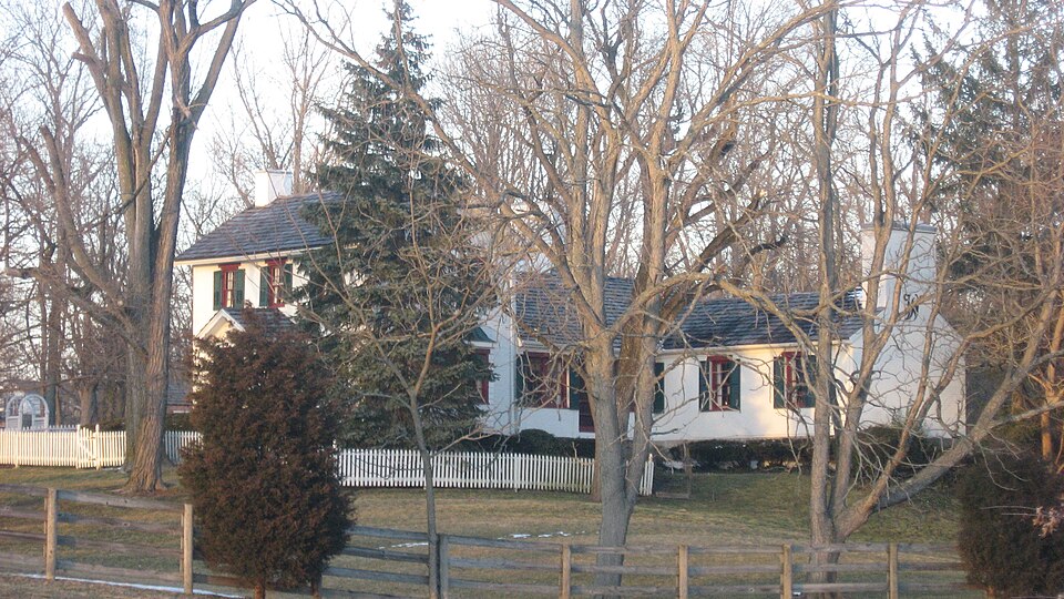
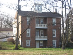
Photograph of Deerwood Farm
Photograph by Nyttend, Public domain. Via Wikimedia Commons.

Deerwood Farm

Listed on the National Register of Historic Places in 1975. A historic map-sheet match is not published yet. The record needs a coordinate-quality review before it can be joined to a sheet boundary.

From the record

“At about the beginning of the century, Martin Davenport and David Hooe Sr., came from North Carolina to the Stillwater region, prospecting for ii , and, on examining that in the vicinity of the present village of Union, i andolph Township, were suited. Davenport died before reaching his home.”

The History of Montgomery County, Ohio, Containing a History of the County; (1882). Machine-read text.

one of 117 National Register listings in Montgomery County · listed in 1975 · category: Building · one of 4 National Historic Landmarks in Montgomery County.

Sources: the county history on the Internet Archive · the case file at the National Archives · the National Register database, National Park Service

The listing

  • What is counted as historic. The nomination lists 3 buildingss as contributing to the listing.
  • Address. N of Dayton at 7200 Peters Pike, Dayton, 45414
  • When was it listed? 1975-11-12
  • Category. building
  • Township. Butler township
  • Architectural style. Federal architecture
  • National Register reference number. 75001507 - the number the National Park Service assigned this property when it was listed, and the key its nomination file is catalogued under at the National Archives.

The ground it stands on

15,552 words

The chapter on Butler Township in The History of Montgomery County, Ohio, Containing a History of the County;, published 1882 names Dayton. This is what it says, exactly as the scans read.

Situated on the left bank of the Great Miami River, on a beautiful and fertile plane, free from inundation by the river, and through which the State road from Dayton to Ginj cinuati, and the county road from Centerville to Germantown pass, completely situated for its future inhabitants.

Passage source: The History of Montgomery County, Ohio, Containing a History of the County;, published 1882.

At about the beginning of the century, Martin Davenport and David Hooe Sr., came from North Carolina to the Stillwater region, prospecting for ii , and, on examining that in the vicinity of the present village of Union, i andolph Township, were suited. Davenport died before reaching his home. Line summer of 1801, several families from the same vicinity of North Caroincluding David Hoover and family and David Mast and family, with fcl L-s, left their native State for this region, and stopped south of Dayton, and k 3 spent the winter, moving in the early spring to the land selected. While ii settlement was made in what has since become Randolph Township, the lament just over the river was made about the same time, and so closely >i ected with it that it is necessary to mention it in order to properly introu the pioneers of Butler Township. Hoover was so delighted with the ap- : nice of the country that, on his return, vivid descriptions of it were given e entire neighborhood, which excited them to a desire for a home in the John Quillan, theD a young man. accompanied these first familes to the A water region, driving thither the team of David Mast, and, soon after their r al, was united in marriage to Obedience, a daughter of Mr. Mast, and set- <<on the opposite side of the river (in Butler Township) to those families, lf/ing the northeast quarter of Section 11. Quillan spent his life in this c ity, living to a ripe old age, dying during the late civil war. He became ather of quite a number of children, who assisted in converting the wilder- *sof that period to the cultivated fields of the present. Mi'. Quillan served e war of 1812. His son William is said to have been the first child bom is township. It is held by some that Thomas Newman came with these to whom be was related, having married a Hoover, and, with his n.y, settled along the east side of Stillwater. We failed to verify this, but, -conversation with Aunt Mollie Sheets, who was a Hoover, and came with e advanced families, that Newman came very soon afterward, if not with l. The families of George Sinks and Henry Yount, hailing from the same uborhood in North Carolina, immigrated to the Stillwater settlement that i year (1802), locating, the former in Section 2, Township 5, Range 5, h e he entered 320 acres of land; and the latter in Section 25, same town- : i and range, entering the full section. He also entered one-half of Section 'ownship 3, Range 6, land adjoining the other tract. Mr. Yount had been 11 ed in North Cai'olina, to Mary Waymire, and had grown children on aig. George Yount entered Section 3, Township 5, Range 5, lying partly 1 hler and partly in Randolph Townships; also a quarter of Section 1, r iship 5, Range 5. The sons and daughters of Henry Yount were John, 1(pw, Daniel and Sarah. In November, 1805, the families of Daniel Wayi and Philip Plummer, coming from Guilford County, N. C., moved on the fif Yount land in Section 25. Yount vacating and going down into Warren 1 ty, on Clear Creek, where he remained two years and returned, and dur- Qs absence Waymire farmed his land, there being two fields of about eightacres cleared. Plummer only remained until spring, and then went furhortli, entering the northwest quarter of Section 13. After raising two ') on the Yount land. AVaymire moved on the section to the north (24), and >i there to the Plummer land, which he purchased. These early families "'-'rail related, and were neighbors in the State of North Carolina. The parwitsjif Daniel Waymire were from Germany, and while crossing the ocean. Hij° the year 1735, the mother died, and her remains were given to the mighty deep. Tlie father's sisters were sold for their passage, and never afterwar heard of. The father settled in North Cai'olina, and again married, and lroi the two unions have since descended over three thousand persons. Fatht Waymire died in 1800, and his children all came to Ohio. Daniel marrie Sophia Plummer, and to them were born Davis, Mary, Solomon, Daniel, Join Catharine, Elizabeth, Henry, Sarah, Rebecca, Rosana and Isabelle, several c whom are now residing in the township. Davis, the oldest, was born in tl year 1802, is hale and hearty, and has resided in the township longer than an one in it, and for a period of nearly forty years served the people as a Jusfch of the Peace, and was their Clerk for thirty years. The father, Daniel W;n mire, died July 3, 1825, and was buried in the old Lutheran Graveyard o "Independence Day;'' the mother, too, was buried there. The Plummt family was large, none of whom are now residing in this locality. The chi dren, as nearly as we could learn, were Sophia, John, Catharine, Sarah, Bets Susan, Delilah and Philemon. Turning your attention to the eastern pari, c the township, where, in Sections 13 and 14, Township 3, Range 6, in the ye? 1806, Richard Sunderland and William Compton settled, having together ei tered 707 acres of land. Sunderland, in company with two brothers, had, pric to the year 1804, entered 160 acres each in Section 20, Washington Townshij where he had been twice burned out. Thence he went to the land above d< scribed. The Sunderlands were from Pennsylvania. The wife of Richard w t Nancy Martin, a native of the Keystone State; their children were William an Elizabeth, twins; the latter married Isaac Miller, the father of the Millers no residing in the eastern part of the subdivision; William Sunderland married daughter of James Miller, and to them were born six children. The parent! Richard and Nancy Sunderland, died, and were buried on the farm, in the yea! 1863 and 1846 respectively. Their remains have since been removed to th cemetery in Miami County. William Compton was from North Carolina. Hi family was quite lai'ge, wife's name was Martha. They belonged to the societj of Friends, or Quakers. Both were interred on the homestead. Mr. Compton! share of the above described entry was 303 acres, lying in the southern part d the sections named. Abijah Jones and family, from North Carolina, settled i] the southern part of the township in 1805. He was a minister of the Friend? society, and his name is the first recorded as such on the books of the old uRai dolph meeting," an account of which will be given under the topic of chuichei Mr. Jones died in 1852, in his eighty-hfth year. Sylvanus Swallow and wife Elizabeth (Barnard), and family, emigrated from North Carolina in the sprin of 1807, and settled in the northeast quarter of Section 29, on land entered b him. Mr. Swallow was a native of Delaware, where he was born February 2c 1776, and his wife of North Carolina, born June 4, 1782. On reaching th above tract of land, Mi'. Swallow pitched his tent, in which the family reside for several months. Their children were James O., John A., Sampson B| Cynthia, Belinda, Catharine and Priscilla. This was a family of Friends, an the remains of the parents were interred at the Friends' meeting-house grave yard. Some time prior to this, the father, John Swallow, came to this locahtj and entered 160 acres in Section 19. The Barnards, consisting of mother an] son, accompanied the family of Sylvanus Swallow and settled in Section A The son was a single man, Samuel by name, and late in life married Rebecc. Compton. Benjamin Hutchins, Sr., of English descent, with a numerous fain ily, settled in Section 29, there entering 160 acres of land, he having com from Rockford County, N. C. Isaac Hutchins, a son of Benjamin, marriei Rebecca Jones, eldest daughter of the old patriarch, Abijah. Their son, Dan iel K. Hutchins, was a minister of the Friends' Society, and served thepeopl of this vicinity many years. Joseph Pearson and wife, Margaret Carnmacl; migrated from South Carolina in 1808, and, after stopping for awhile on land ,waed by George Yount, on the west side of Stillwater, crossed that stream and atered one-half of Section 1, Township 5, Range 5. They raised a large iniily of children, two of whom are the wives of Davis and Henry Waymire. r. Pearson, as likewise did other of the above-named families, left the South ainlyon account of slavery. He did not want to raise his children under its ifluences. Father Pearson died January 17, 1840, and the mother July 17, 154. Prior to the year 1809, the following-named had settled between the fo rivers, but at what date they came we cannot establish, but it is evident .at they were here before the beginning of the second decade of the century : >hn Curtis, Joseph Beeson, Daniel and Stephen Jones, John Holderman, the itbles, Henry Crowel, Henry Woodhouse, James Insco, James Reed, William allohan, Joseph Evans, John Mooney, Benjamin Kiser, Jacob Stokes, John ryback, David Fox. William Miller, Jacob Rhodelhamer, John Sloan and ichael Engle. Mr. Curtis was from North Carolina, and entered one-quarter

Passage source: The History of Montgomery County, Ohio, Containing a History of the County;, published 1882.

Machine-read from a century-old scan, so expect the errors a machine makes: misspelled names, dropped words, stray characters.

Read the whole chapter on Butler Township - 15,552 words on its settlement, mills, schools and churches.

Specimens collected near this property

12 of 974 shown

Regional context, not property-specific evidence. Museums hold 974 specimens collected within 10 miles of Deerwood Farm between 1835 and 1975: 821 Animalia, 87 Plantae, 58 Fungi, 4 Unrecorded, 3 Protozoa, 1 Chromista. 12 distinct Species records are shown. Collected by A. E. Foeerste, A. E. Foerste, A. F. Foerste and others. Each is a physical object with a catalogue number, and each entry opens the museum's record. This is what was collected and kept, not a survey of what lives here - nothing can be concluded from a species being absent.

Image SpeciesYear Collected by Where, as recorded
Specimen of Ambrosia artemisiifolia L.Ambrosia artemisiifolia L.1881Foerste AF
Specimen of Geaster limbatus Fr.Geaster limbatus Fr.1883A. E. FoeersteDayton
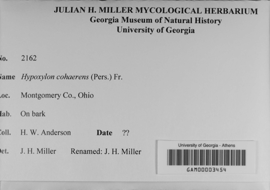
Specimen of Hypoxylon cohaerens (Pers.) Fr.Hypoxylon cohaerens (Pers.) Fr.1897H. W. Anderson
A photograph of the species Botrypus virginianus, not of this specimenBotrypus virginianus (L.) Michx.1835Joseph C. FrankOhio, Miami [County]
A photograph of the species Platanthera leucophaea, not of this specimenPlatanthera leucophaea (Nutt.) Lindl.1836C. W. ShortDayton
A photograph of the species Erythronium americanum, not of this specimenErythronium americanum Ker Gawl.1837van Cleve, John W.3 mi. north of Dayton
A photograph of the species Hydrophyllum macrophyllum, not of this specimenHydrophyllum macrophyllum Nutt.1838J. W. Van CleveDayton
A photograph of the species Allium canadense, not of this specimenAllium canadense L.1839not recordedDayton. 1 mi. northeast.
A photograph of the species Cardamine L., not of this specimenCardamine L.1839Sanders, Alfred; J.J. Nagel, J.G. Haupt.Dayton. 1 mile east.
A photograph of the species Cassia marilandica, not of this specimenCassia marilandica L.1839Sanders, AlfredDayton
A photograph of the species Cynoglossum officinale, not of this specimenCynoglossum officinale L.1839not recordedDayton. Suburbs E.
A photograph of the species Iris versicolor, not of this specimenIris versicolor L.1839not recordedDayton. 2 mi. south

All 974 specimens within 10 miles, at the Global Biodiversity Information Facility.

Mines and quarries near this property

10 of 13 shown

Regional context, not property-specific evidence. The federal mineral resources record lists 13 workings within 5 miles of Deerwood Farm: 6 producers, 5 past producers, 2 plants. 8 still produce. What was taken out: Sand and Gravel, Construction, Stone, Crushed/Broken. Distance is straight-line from the map coordinates, so a quarry counted here may appear on a neighbouring settlement's page as well.

Where SiteCommodity StatusRecorded
Southwestern PitStone, Crushed/BrokenProducer
Wayne QuarryStone, Crushed/BrokenProducer
Cassel PitSand and Gravel, ConstructionProducer
Cassel Sand & Gravel, Inc.Sand and Gravel, ConstructionPast Producer
Haas Sand and Gravel PitSand and Gravel, ConstructionPast ProducerSedimentary
Haas Sand and Gravel PitSand and Gravel, ConstructionPast Producer
Miller Brothers Gravel, Inc. PitSand and Gravel, ConstructionPast ProducerSedimentary
Northmont Sand and Gravel PitSand and Gravel, ConstructionProducer
Northmont Sand and Gravel PitSand and Gravel, ConstructionPast ProducerSedimentary
Rip Rap Road Plant 416 & PitSand and Gravel, ConstructionPlant

Every working recorded in Montgomery County

Storms near this property

60 of 74 shown

Regional context, not property-specific evidence. The National Weather Service names Dayton, the town this property stands in, in 74 storm reports between 1994 and 2026: 41 thunderstorm wind, 15 hail, 8 flash flood, 7 flood. The reports record 1 injury. Each account below is quoted exactly as the forecast office filed it, from the NOAA Storm Events Database, and each date opens the federal record of that event.

WhenEvent Place namedHarm What the report says
April 2015LightningDayton1 hurtA University of Dayton student, Sean Ferguson, 23 of Pittsburgh, was struck by lightning as he ran across university parking lot C. The student was hospitalized with serious burns and a broken jaw.
April 2000Thunderstorm WindDayton$200,000Thunderstorms winds measured by spotters as high as 72 mph downed numerous trees, many of which fell on cars and blew on to and into homes. A construction trailer was severely damaged and some businesses received damage.
June 2001LightningDayton$100,000Lightning struck a building causing it to catch on fire.
July 1994Thunderstorm WindDayton$50,000Trees were downed. A large propane tank was blown over near Dayton. Large hail fell over the western part of Dayton.
June 1999Thunderstorm WindDayton$30,000A roof was blown off of a residence in East Dayton as well as several utility poles that were snapped in half. Numerous trees were down in the vicinity of Glenrock Road and East Fifth Street. Several trees landed on parked automobiles and garages.
August 2021Flash FloodDayton$10,000A few motorists were stranded in high water near downtown Dayton.
June 2014Thunderstorm WindDayton$10,000Large limbs were downed at Patterson and River Park due to thunderstorm winds. Two large trees were also downed in the area. One tree fell on a house.
June 2014FloodDayton$10,000High standing water under an overpass trapped a man on top of a car near Linden Avenue and Livingston Avenue.
August 2011Thunderstorm WindDayton$10,000Large tree limbs were reported down due to damaging thunderstorm winds. One of these tree limbs crushed a car.
July 2002Thunderstorm WindDayton$10,000Several trees were blown down.
August 2007Thunderstorm WindDayton$8,000Large tree limbs were downed. A tree fell on a house in Oakwood, causing minor structural damage.
June 2005Thunderstorm WindDayton$8,000Several large trees were downed across the southern Dayton metro area. An eight-foot diameter tree fell on a house.
June 2000Thunderstorm WindDayton$7,000Several trees were blown down in Butler Township.
May 1995Thunderstorm WindDayton$6,000Several trees were downed, some across power lines. Eight-three people were without power for a short period of time.
May 2019Thunderstorm WindDayton$5,000A tree was downed onto a house on 5 Oaks Avenue.
March 2011FloodDayton$5,000Several roads were flooded due to heavy rainfall.
April 2003Thunderstorm WindDayton$5,000Several trees were downed in the city.
June 2001Flash FloodDayton$5,000Two feet of water on roadways across eastern part of county
August 2000Thunderstorm WindDayton$5,000Trees knocked down in the southwestern part of the city. A wind gust of 62 mph was reported at the Dayton Dailey News building in downtown.
July 2000Thunderstorm WindDayton$5,000Trees knocked down.
August 1998Thunderstorm WindDayton$5,000Trees knocked down.
April 2026Thunderstorm WindDayton$4,000A tree fell onto some power lines.
June 2001Thunderstorm WindDayton$4,000Several trees and power lines reported down
February 2024Thunderstorm WindDayton$3,000Some wires were downed on Green Street.
February 2024Thunderstorm WindDayton$3,000Wires were downed on Drummer Avenue.
August 2021Thunderstorm WindDayton$3,000A few trees were downed in the city of Dayton.
July 2011Thunderstorm WindDayton$3,000Large limbs were reported broken. A large tree was uprooted. Numerous large tree limbs were down in the road. These occurrences were due to damaging thunderstorm winds.
June 2008Thunderstorm WindDayton$3,000Large tree limbs were downed.
May 2008HailDayton$3,000A few large tree limbs were also knocked down.
June 2008Thunderstorm WindDayton$3,000Large tree limbs were downed.
March 2007FloodDayton$3,000A few roads were flooded and closed throughout the Dayton metro area.
August 2003Thunderstorm WindDayton$3,000Trees and powerlines were downed.
July 1995Thunderstorm WindDayton$3,000Large trees were downed, some across city streets.
May 1996Thunderstorm WindDayton$3,000no account filed
January 2008Thunderstorm WindDayton$2,000Large tree limbs were knocked down.
March 2022Thunderstorm WindDayton$1,000A tree was downed onto Fountain Avenue.
July 2015Thunderstorm WindDayton$1,000A large tree was blown down.
June 2014Thunderstorm WindDayton$1,000A large limb was downed on Wyoming Street due to thunderstorm winds.
December 2013Flash FloodDayton$1,000Multiple roads were closed countywide due to high water caused by heavy rainfall.
January 2012FloodDayton$1,000Several roads in the area were reported closed due to high water caused by heavy rain.
June 2012Thunderstorm WindDayton$1,000Multiple large tree limbs were downed due to damaging thunderstorm winds.
May 2011Thunderstorm WindDayton$1,000A tree was down across a road due to damaging thunderstorm winds.
May 2011Thunderstorm WindDayton$1,000A large tree was uprooted due to damaging thunderstorm winds.
June 2010Thunderstorm WindDayton$1,000Large tree limbs were reported down due to damaging thunderstorm winds.
August 2010Thunderstorm WindDayton$1,000Several large branches were reported down due to damaging thunderstorm winds.
June 2008FloodDayton$1,000A foot to a foot and a half of water was standing on South Patterson between Apple and Stewart Roads.
April 2008HailDayton$1,000no account filed
June 2020Thunderstorm WindDayton$500A large limb was knocked down into the parking lot of the downtown Dayton YMCA parking lot.
July 2016Flash FloodDayton$500A car was stranded on Keowee Street under State Route 4 due to high water. Three feet of water was also reported on Webster Street at the underpass of State Route 4.
June 2025Flash FloodDayton-Several inches of water were flowing across the roadway near the intersection of Wilfred and St Charles Avenues.
June 2025Flash FloodDayton-Several inches of water were flowing across Carlisle Avenue and Tacoma Street.
August 2020FloodDayton-Street flooding was reported on U.S. 35 and I-75.
April 2017Thunderstorm WindDayton-Dime size hail was reported as well.
June 2017HailDayton-Hail size was estimated from social media photo.
August 2016Thunderstorm WindDayton-Winds were estimated by a trained spotter.
June 2015Heavy RainDayton-Water was covering a road at the University of Dayton.
April 2015HailDayton-In addition to the hail, small limbs were knocked down by estimated 60 MPH winds.
May 2014FloodDayton-A car was stalled in standing water beneath a railroad overpass due to heavy rainfall.
June 2012Thunderstorm WindDayton-The spotter estimated the speed of the wind gust.
September 2002Flash FloodDayton-Numerous roads were flooded throughout the Dayton metropolitan area. A man had to be rescued when he drove his car into a flooded retention pond near the Dayton Mall.

Every storm recorded in Montgomery County

Newspapers printed here

0 digitised pages

8 papers published in this town, digitised by the Library of Congress and free to read: 0 issues, 0 pages. Every page is searchable, so a name or a street can be looked for directly in what the town printed about itself at the time.

NewspaperPublished
The Daily Bulletin1942 to 1946
The Dayton Forum1913 to 1949
Dayton Union News1940 to 1944
Dayton Daily Empire1850 to 1865
The Daily Express1950 to 1955
The Ohio Daily-Express1946 to 1950
The Daily Empire1865 to 1867
The Dayton Citizen1950 to 19??

Map coverage status

No historic map-sheet match is published for this property yet. That does not mean no map exists. This record needs a coordinate-quality review before it can be joined to a sheet boundary. Browse the county's mapped places while that work is pending.

From the nomination file

2,779 words on record

When this property was proposed for the National Register, someone wrote the case for it: what the building is, and why it matters. That document is a federal record in the public domain. It is quoted below word for word, never summarised. The text was read off the scanned case file by machine, so the occasional stray character is the recogniser's and the 1970s typewriter's.

Description of the property

The foundation of the original house is coursed stone enclosing a partial basement that has a fireplace. 1The walls ed shake gable roof verges projecting plain with frieze. The with stoop and a porch styled like the front porch and an' addition is frame,has three bays with central door, and a Most of the interior Federal wood trim, cupboards and CONDITION Moved Ruins with a vertical board top section and shingled gable roof.A A rustic Federal style farm house constructed sometime inch steep stairway gives access to the low ceiling rooms of gable roof and interior end chimney. transom.

Straight steps approach a small concrete porch the house and across the creek is a springhouse of large rocks doors have been preserved and the trim of the additions have rough hewn logs that reach up to twenty-six feet, and the story only and four light gable casement windows each side of tract of 40.66 acres in a suburb of widely spaced homes, family room extended the back addition of 1937 south into The rear wing was extended three bays in 1937 which completed the additions which all extend to the rear. chimney is interior left end at the ridge line. The house is situated135 feet back from the road on a an L plan in 1970.The house is not adversely effected by (Check One) around 1813. The windows are 6/6 lights with black been milled to match.

bays with the rectangular doorway centered with three light rails. Floors throughout are random width chestnut. All The medium pitch- roof rafters are rough hewn saplings.

Read the complete 2,779-word case file.

Statement of significance

a quarter section patented on October 10, 1812 to Benjamin a sale by Jones to Tommy Hutchins attached the house now of Friends, settled with his family in 1805. Stephen Jones among the settlers arriving in Butler township in the Benjamin, owner of the property from 1850 to his death sometime before 1895 married Rebecca Jones, eldest daughter Society, bought the north half of the quarter section and Architecture Commerce Conservation Landscape Science Industry Military losophy Transportation Engineering Communications Agriculture Theater Aboriginal Education Music Invention Pre-Columbian with the exception of some legal manipulations.

many years and their cemetery is the resting place of Political in appropriate antiques by the Weisenborns.It is freely first decade of the nineteenth century and puts him on thee Urban Planning Social/Human- Sculpture Religion/Phi- is not clearly connected in the record but he was a prominent The Society of Friends maintained a meeting house there for earliest property date. architecturaleevidence strongly suggests a time near the The house stands on a one acre ninety perches part of many early settlers. The township received its first settlers in 1802. later and subsequently to Stephen Jones in 182l.In 1846 turned over the northwest corner to the Mill Creek Meeting Deerwood Farm is.a significant example of an early east of Peters Pike to a farm in the southeast quarter.

The land remained with Tommy Hutchins's heirs until l902, Abijah Jones,"The Old Patriarch," minister of the Society PERIOD (Check One or More as Appropriate) XX 19th Century Ohio farm house in rustic Federal style.

Read the complete 2,779-word case file.

The whole case file for this property - 2,779 words, 28 pages, reproduced complete.

Quoted from the National Register nomination for reference 75001507, 28 pages, held by the National Archives in Record Group 79. See the catalogue record.

Listed places nearby

6 within 8 miles

Other National Register properties close enough to walk or drive between, ordered by distance from this one. Both positions come from the same geocoding pass that matched these properties to their map sheets.

Photograph PropertyDistance Listed
Taylorsville Canal Inn3.4 miles1977
Sears, Roebuck and Company3.4 miles2023
Miami-Erie Canal Lock No. 703.7 miles1982
Red Oak--Sherman, William C., House4.0 miles2000
Martindale, Samuel, House4.3 miles1978
Mumma, Jacob H. W., House4.4 miles1980

Sources for this property

National Archives recordThe nomination case file for reference 75001507 in Record Group 79.
Montgomery CountyAll 117 listed properties in this county.

Provenance

  • Listing record. National Park Service National Register of Historic Places, listed-properties dataset, current to 2026-05-22.
  • Map join. Address geocoded through the United States Census geocoder, then tested against the published boundary of every sheet in the USGS Historical Topographic Map Collection.
  • How this page is made. Listing fields come from federal records; map-sheet coverage is a labelled coordinate-to-boundary calculation, not a source-field claim.
  • Specimens. Global Biodiversity Information Facility (GBIF), https://www.gbif.org/. Only records licensed CC0 or CC BY are used. Records licensed CC BY-NC are excluded because this site carries advertising. Images are checked individually and any whose licence is non-commercial, no-derivatives or unreadable is refused.
  • Mines and quarries. USGS Mineral Resources Data System (MRDS) https://mrdata.usgs.gov/mrds/ A work of the United States government, no copyright under 17 U.S.C. 105.
  • Storms. NOAA National Centers for Environmental Information, Storm Events Database https://www.ncei.noaa.gov/stormevents/ A work of the United States government, no copyright under 17 U.S.C. 105. Narratives are quoted verbatim from the National Weather Service report and are not edited or summarised.