Listed on the National Register of Historic Places in
1982. A historic map-sheet match is not published yet. The record needs a coordinate-quality review before it can be joined to a sheet boundary.
From the record
“Allen came to the pulpit, and served the congregation until August, 1854, when he took charge of the church at New Concord. Handel, for one year, from September, 1854, when Elder Hugh Brown became the pastor, and served until September, 1859. ^^ ^'^~ tober, of that year, C.”
1794. History of Muskingum County, Ohio, with Illustrations and Biographical Sketches of Prominent Men and Pioneers (1882). Machine-read text.
one of 70 National Register listings in Muskingum County · listed in 1982 · category: Building.
National Register reference number.82003622- the number the National Park Service assigned this property when it was listed, and the key its nomination file is catalogued under at the National Archives.
What happened here
An account from the chapter on Monroe township, The inset identifies its exact
source book and publication year.
The territory comprising this township is situated in the extreme northeast corner of Muskingum county. It is drained entii-ely by "White Eyes" creek, (so named in commemoration of the noted Indian by that name, who, notwithstanding he was indeed the white man's friend, was murdered by white men). The stream traverses it from the southwest to the northeast corner.
In August, 185 1 ,_Rev. B. Allen came to the pulpit, and served the congregation until August, 1854, when he took charge of the church at New Concord. The church was then supplied by Rev. E. W. Handel, for one year, from September, 1854, when Elder Hugh Brown became the pastor, and served until September, 1859. ^^ ^'^~ tober, of that year, C. T. Emerson, a licentiate, from Newcomerstown, Tuscarawas county, Ohio, moved into the vicinity of the church, was ordained, and became their pastor, and served until September, 1862, when he resigned.
In August, 1851,Rev. B. Allen came to the pulpit, and served the congregation until August, 1854, when he took charge of the church at New Concord. The church was then supplied by Rev. E. W. Handel, for one year, from September, 1854, when Elder Hugh Brown became the pastor, and served until September, 1859. In October, of that year, C. T. Emerson, a licentiate, from Newcomerstown, Tuscarawas county, Ohio, moved into the vicinity of the church, was ordained, and became their pastor, and served until September, 1862, when he resigned.
Regional context, not property-specific
evidence. The
federal wildfire occurrence database
lists 17 fires within 5 miles of McCully Log House between
2009 and 2020, burning about 42 acres in total. None started naturally. None was recorded as arson.
Distance is straight-line from the map coordinates, so a fire counted
here may appear on a neighbouring settlement's page as well.
Reported cause
Fires
Debris and open burning
11
Missing data/not specified/undetermined
4
Power generation/transmission/distribution
1
Recreation and ceremony
1
The most recent of
them, most recent first, with the day each was reported and the service
that recorded it.
Regional context, not property-specific
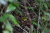
evidence. Museums hold 1,159 specimens
collected within 10 miles of McCully Log House between 1908 and
1975: 852 Animalia, 301 Plantae, 3 Fungi, 3 Unrecorded. 12 distinct Species records are shown.
Collected by A. H. Wright, Adams, W., Adams, W. (William), Trautman, M. B. (Milton Bernard) et al. and others. Each is a
physical object with a catalogue
number, and each entry opens the museum's record. This is what was
collected and kept, not a survey of what lives here - nothing can be
concluded from a species being absent.
Regional context, not property-specific
evidence. The National Weather Service names
New Concord, the town this property stands in, in 16 storm reports between 1995 and 2025: 11 thunderstorm wind, 4 hail, 1 flash flood.
No death or injury is recorded in these reports. Each account below is quoted exactly as the forecast office
filed it, from the NOAA Storm Events Database, and each date
opens the federal record of that event.
Rte 83 was flooded between Bloomfield and Otsego in the northeast part of Muskingum County, beginning at 632 AM EDT. By 835 AM EDT, there was flooding in Adamsville; and along State Rte 16 in Adams Mills. One house was surrounded by water in Otsego area.
No historic map-sheet match is published
for this property yet. That does not mean no map exists. This record needs
a coordinate-quality review before it can be joined to a sheet boundary.
Browse the county's mapped places while that work is
pending.
From the nomination file
1,651 words on record
When this property was proposed for the
National Register, someone wrote the case for it: what the building is,
and why it matters. That document is a federal record in the public domain.
It is quoted below word for word, never summarised. The text was read off the scanned case file by machine, so the
occasional stray character is the recogniser's and the 1970s
typewriter's.
Description of the property
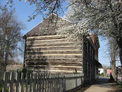
Several wood frame outbuildings exist on the site.A smokehouse is located The interior of the original portion of the house features 2 rooms on the first extant dependencies:a wood frame bank barn (which replaced a log barn which was _unexposed is constructed of hewn logs, probably poplar or oak, six logs to the plate, with the logs featuring the "steeple notch" form of corner notching. In the north gable end is floor, a partially dug fruit cellar, and a large room on the second story. The second date which is presently being removed in the course of the restoration project. against the east elevation (photo #1) is a shed-roof wood frame addition consisting of 8.
Statement of significance
(in one paragraph) in that it is a log house of two full stories, virtually intact and unaltered. This was especially true along the ridges, well above streams which could power sawmills. In Monroe Township, where the McCully house is located, there was a sawmill as early as 1817 and the first wood frame house, which still stands, was erected by the sawyer, Martin Richardson, shortly thereafter. houses were the easiest to construct. Today, northern Muskingum County -- especially Monroe Township :- is being severely altered by coal-stripping.
and record exists in published county histories, and the only sources of information died young, since the 1860, 1870, and 1880 census' mention his widow, Jane According to Donald Hutslar, expert on Ohio log architecture, the use of 1600-1699 1700-1799 1500-1599 1400-1499 transportation theater engineering communications industry education Period humanitarian commerce conservation invention exploration/settlement science Xarchitecture 1900- many early structures are disappearing.The McCully House remains intact law The McCully Log House derives its significance from its architecture, and is an important survival of a once-popular architectural style.
mining in this portion of the county has eliminated most vestiges of this early Log architecture was the most prevalent of the folk architectural styles in Areas of Significance-Check and justify below agriculture military are the census and two early county atlas maps.As early as 1854,William Little is known of the McCullys who apparently built the house.No southeastern Ohio.Trees were plentiful and since land had to be cleared, cut sandstone block for the rear wall of the fireplace is a locally distinctive - other(specify) -art _ archeology-prehistoric - community planning .landscape architecture. McCully, (born 1822 in Ohio), as the resident. early settlers in rural Muskingum County built almost exclusively of logs.
Quoted from the National Register nomination
for reference 82003622, 12 pages, held by the National Archives in Record
Group 79. See the
catalogue record.
Listed places nearby
6 within 8 miles
Other National Register properties close
enough to walk or drive between, ordered by distance from this one. Both
positions come from the same geocoding pass that matched these properties
to their map sheets.
Listing record. National Park Service National Register of Historic Places, listed-properties dataset, current to 2026-05-22.
Map join. Address geocoded through the United States Census geocoder, then tested against the published boundary of every sheet in the USGS Historical Topographic Map Collection.
How this page is made. Listing fields come from federal records; map-sheet coverage is a labelled coordinate-to-boundary calculation, not a source-field claim.
Wildfire. Short, Karen C. 2022. Spatial wildfire occurrence data for the United States, 1992-2020 [FPA_FOD_20221014]. 6th Edition. Fort Collins, CO: Forest Service Research Data Archive. https://doi.org/10.2737/RDS-2013-0009.6 Collected with United States Government funding and usable without additional permissions or fees.
Specimens. Global Biodiversity Information Facility (GBIF), https://www.gbif.org/. Only records licensed CC0 or CC BY are used. Records licensed CC BY-NC are excluded because this site carries advertising. Images are checked individually and any whose licence is non-commercial, no-derivatives or unreadable is refused.
Storms. NOAA National Centers for Environmental Information, Storm Events Database https://www.ncei.noaa.gov/stormevents/ A work of the United States government, no copyright under 17 U.S.C. 105. Narratives are quoted verbatim from the National Weather Service report and are not edited or summarised.
 Block
Block