 Block
Cambridge, Illinois
11 topographic sheets cover this place, the earliest surveyed in 1934 and the latest in 1991. It stands in Cambridge Township. It lies in ZIP code area 61238. The Survey maps it on the Cambridge quadrangle. 2,086 people lived here at the 2020 count. It stands 801 feet above sea level.
On record in Cambridge
Buildings and businesses the archive holds for this place. Each opens its own page, with the source record it came from.
On the National Register 1 record
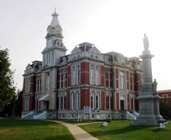 Henry County Courthouselisted 2004
Population over time
2 figuresCambridge fell from 2,160 to 2,086 between 2010 and 2020. These are the recorded population figures Wikidata holds for this place, reached through the Geographic Names Information System number this page is keyed on rather than by name, so they belong to this place and not to another of the same name. Most are census counts, but not all are: an early figure may be a founding or settlement estimate, and an estimate published within five years of a census is left out. The change column is computed, and is left blank where more than 20 years separate a figure from the one before it, because a gap that long is not a change between two counts.
| Year | People | Change |
|---|---|---|
| 2010 | 2,160 | |
| 2020 | 2,086 | -74 (-3%) |
Topographic sheets covering this place
8 surveys from 11 printed sheetsMatched by testing this settlement's coordinate against the published boundary of every sheet in the United States Geological Survey's historical collection. Each opens the scanned sheet at the Survey.
- 1934 USGS Geneseo quadrangle1:62500, 2 printings
- 1953 USGS Cambridge quadrangle1:24000, 2 printings
- 1958 USGS Davenport quadrangle1:250000, 2 printings
- 1961 USGS Davenport quadrangle1:250000
- 1962 USGS Davenport quadrangle1:250000
- 1984 USGS Aledo quadrangle1:100000
- 1989 USGS Aledo quadrangle1:100000
- 1991 USGS Cambridge quadrangle1:24000





What happened here
An account from the chapter on Cambridge township. The inset identifies its exact source book and publication year.
Bank Robbery
The good people of the county, more especially oi Kewanee, were, in the latter part of August, 1882, startled by the news that the First National Bank of Kewanee had been robbed in broad daylight. Two armed men had entered the bank, just after the close of business hours, and, by violence overcoming the only two employees in the room at the time, had carried off the money, first throwing these two persons - the assistant cashier, Mr.
In the county-history sources
40,471 words on this townshipHistory of Henry County, Illinois : It's Taxpayers and Voters; Containing Also, a Biographical Directory, a Condensed History of the State; Map of the County; a Business Directory...etc, published 1877 names this settlement in its chapter on Cambridge Township. These are the passages that mention it, exactly as the scans read.
The land on which the town of Cambridge now stands was, prior to the year 1843, the property of Rev. Ithamar Pillsbury, so well known in the early history of the New York and New England 'Colonies' finding homes in Henry County. As soon as the site received legislative sanction - the act having passed that body February -1, 1843, - he deeded to the Board of County Commissioners, at a special meeting held on April 19, 1843, the fractional parts of two forty-acre lots. These were at once accepted, and steps taken to lay out a town. A contract had been made between the county and Geo. Brandenburg and Corey for constructing a jail and court-house at Morristown. A small frame court-house was already built, but at this time was still unfinished, and but little work had been done on the jail. By consent of these parties this contract was annulled, the settlement being left to Marcus B. Osborn, N. W. Washburn and Luke C. Sheldon, as referees. They gave their decision at the regular term of the court, held on the 6th of June following. This was to pay the contractors fl27.2(>, and keep the building. A day or two after the court met again, at the cabin commenced by J. Tillson and finished by A. H. Showers, in Sugar Tree Grove, for the transaction of any business relating to the new town.
Passage source: History of Henry County, Illinois : It's Taxpayers and Voters; Containing Also, a Biographical Directory, a Condensed History of the State; Map of the County; a Business Directory...etc, published 1877.
It was ordered that the Court proceed forthwith to the sale of lots in Cambridge, on the following terms : One-third to be paid in six months after date of sale ; one-third in twelve months, and the remainder in eighteen months ; and that purchasers have the privilege of paying in building materials, on or before the 1st day of the September following. George McHenry, being in his place as auctioneer, a full board, and a good attendance of citizens, the sale proceeded. Twenty lots were sold on that occasion, aggregating the sum of $558. For the benefit of those interested, the list of purchasers and number of lot, and amount of sale, in the order in which they appear on record, are given: Joseph Tillson,
Passage source: History of Henry County, Illinois : It's Taxpayers and Voters; Containing Also, a Biographical Directory, a Condensed History of the State; Map of the County; a Business Directory...etc, published 1877.
To effect a healthy growth in the new town, roads must be opened, post routes established through it. and a post-office in it, and public buildings had to be erected and population invited. The sequel will show that many opposed to the growth of the place scarcely ceased to underrate the locality and its facilities for a healthy growth, and the idea of settling in it or about it was often derided. A mail route leading from Wethersfield to Geneseo was established through the place, and for a while the few inhabitants enjoyed the luxury of a semi-weekly mail from Peoria. By some means the route was altered so as to leave Cambridge out. Previous to the change of route by the department, the carrier refused to go to Cambridge, but would throw out a bag of mail matter put up at Wethersfield expressly for Cambridge, at the " Corners," ten miles east of town. No office being there, a boy employed for the purpose would proceed at his leisure, pick up the bag and take it to its destination. More than once mail matter has been sent from Cambridge for the east and returned at the end of the weeTc with other mutter designed for Cambridge. Those who had important business to transact were afraid to mail their letters at the county town, because of the delays to which its mail was subjected. Many and unsuccessful were the efforts to have that route re-established through the village, nor till 1856 had the tardy justice of a tri-weekly mail from Geneseo to Kewanee been accorded to the county town. A weekly mail from Princeton, in Bureau County, to Millersburg or New Boston, on the Mississippi River, was the only one from which, for several years, news from the east could be obcained. A weekly mail running from Rouk Island to Cambridge was also established for the particular benefit of the settlements between the two places. For a short time, about the year 1853, a route was established from a point on the Illinois River, known as Lancaster, to Cambridge ; but it afforded no conveniences for any office on the route, and was soon discontinued. The mail to Rock Island was carried for many years by a Mr. Robinson, familiarly known as " Uncle Bobby." He was a very honest, trusty man, and made more money by attending to errands at Rock Island for his neighbors than by carrying the mail.
Passage source: History of Henry County, Illinois : It's Taxpayers and Voters; Containing Also, a Biographical Directory, a Condensed History of the State; Map of the County; a Business Directory...etc, published 1877.
Machine-read from a century-old scan, so expect the errors a machine makes: misspelled names, dropped words, stray characters.
Read the whole chapter on Cambridge Township - it names this place 164 more 164 times.
Fires near this place
2 since 2008Regional context, not property-specific evidence. The federal wildfire occurrence database lists 2 fires within 5 miles of Cambridge in 2008, burning under an acre in total. None started naturally. None was recorded as arson. Distance is straight-line from the map coordinates, so a fire counted here may appear on a neighbouring settlement's page as well.
| Reported cause | Fires |
|---|---|
| Missing data/not specified/undetermined | 1 |
| Equipment and vehicle use | 1 |
The most recent of them, most recent first, with the day each was reported and the service that recorded it.
| Date | Cause | Size | Reported by | Name on the report |
|---|---|---|---|---|
| 7 May 2008 | Equipment and vehicle use | under an acre | Illinois Division of Forestry Resources | VINCIENT |
| 5 April 2008 | Missing data/not specified/undetermined | under an acre | Illinois Division of Forestry Resources | STACH |
Settlements close enough to share some of these fires:
Mines and quarries near this place
1 within 5 milesRegional context, not property-specific evidence. The federal mineral resources record lists 1 working within 5 miles of Cambridge: 1 past producer. None of them still produces. What was taken out: Stone. Distance is straight-line from the map coordinates, so a quarry counted here may appear on a neighbouring settlement's page as well.
| Where | Site | Commodity | Status | Recorded |
|---|---|---|---|---|
| Henry City Pit | Stone | Past Producer |
Storms near this place
52 since 1996Regional context, not property-specific evidence. The National Weather Service names Cambridge in 52 storm reports between 1996 and 2026: 28 thunderstorm wind, 21 hail, 1 flash flood, 1 lightning. No death or injury is recorded in these reports. Each account below is quoted exactly as the forecast office filed it, from the NOAA Storm Events Database, and each date opens the federal record of that event.
| When | Event | Place named | Harm | What the report says |
|---|---|---|---|---|
| September 2008 | Flash Flood | Cambridge | $250,000 | Heavy rains caused flash flooding of parts of Henry County during the afternoon of September 13.||East of Galva, flood waters were flowing over Highway 34.||Near Cambridge, several basements were flooded. |
| September 2010 | Lightning | Cambridge | $50,000 | Lightning struck a building in Cambridge, IL around 940 pm CDT September 18. Some bricks were knocked out of the building. |
| April 2003 | Hail | Cambridge | $50,000 | no account filed |
| May 2000 | Thunderstorm Wind | Cambridge | $50,000 | no account filed |
| June 2010 | Thunderstorm Wind | Cambridge | $30,000 | Severe thunderstorm winds damaged tents, concession booths, fences, and large trees at the county fairgrounds, where the annual county fair was underway. |
| July 2008 | Thunderstorm Wind | Cambridge | $15,000 | Wind gusts estimated to be 70 mph blew a tree down onto a garage about 1 mile west of Cambridge, IL at 620 am July 21. Several four inch diameter branches were also blown down across the area. |
| March 2006 | Hail | Cambridge | $8,000 | Hail ranging from pea to golfball. |
| April 2006 | Thunderstorm Wind | Cambridge | $2,000 | EM estimated 60 mph winds |
| May 2011 | Thunderstorm Wind | Cambridge | $1,000 | Wind gusts estimated to be 65 mph snapped a power pole in half just south of Cambridge, IL around 1050 am CDT May 29. |
| July 2006 | Thunderstorm Wind | Cambridge | $1,000 | 5 inch diameter tree split down the middle. |
| March 2026 | Hail | Cambridge | - | Trained spotter reported penny size hail occurring right now. |
| March 2025 | Thunderstorm Wind | Cambridge | - | Recorded gust with wind measuring equipment. |
| May 2024 | Thunderstorm Wind | Cambridge | - | A large tree branch was blown down. |
| July 2024 | Thunderstorm Wind | Cambridge | - | The Emergency Manager reported lots of damage in town. They estimated the winds to be between 80 to 100 MPH. |
| June 2024 | Thunderstorm Wind | Cambridge | - | Measured from a personal weather station, with time estimated by radar. |
| June 2024 | Thunderstorm Wind | Cambridge | - | Cable lines downed by thunderstorm winds. |
| March 2020 | Tornado (EFU) | Cambridge | - | Spotter reports and photos confirm that a brief tornado occurred southwest of Cambridge Illinois on Saturday evening. There was no observable damage from which the NWS could assign an EF-scale rating for the tornado. |
| July 2020 | Thunderstorm Wind | Cambridge | - | A large area of corn was flattened along with a few destroyed farm outbuildings. |
| July 2020 | Thunderstorm Wind | Cambridge | - | A portion of an 8 inch diameter tree branch and several other smaller branches were broken. |
| June 2020 | Thunderstorm Wind | Cambridge | - | Large branches and a few trees blown down. |
| June 2020 | Thunderstorm Wind | Cambridge | - | A tree was uprooted by strong winds. |
| June 2019 | Thunderstorm Wind | Cambridge | - | A trained spotter reported that several small tree branches about 3 inches in diameter were down along with power lines. |
| June 2018 | Thunderstorm Wind | Cambridge | - | Power lines were blown down in Cambridge. |
| August 2018 | Thunderstorm Wind | Cambridge | - | The emergency manager relayed numerous reports of widespread tree damage across the county. Most of the damage was downed tree branches along with a couple of trees down on roadways. |
| March 2017 | Hail | Cambridge | - | A trained spotter reported stones up to the size of dimes. |
| June 2017 | Hail | Cambridge | - | Winds also gusted to 40 mph. |
| March 2017 | Hail | Cambridge | - | A few stones up to a diameter of 1 inch fell. |
| March 2017 | Hail | Cambridge | - | Hail lasted 5 minutes, the hailstones covered the ground. |
| May 2013 | Thunderstorm Wind | Cambridge | - | Law enforcement reported trees down. |
| May 2013 | Thunderstorm Wind | Cambridge | - | A trained spotter measured 62 mph winds ahead of the storms and there was a lot of blowing dust. |
| June 2013 | Thunderstorm Wind | Cambridge | - | Thunderstorm wind gusts were estimated at 50 to 60 mph. |
| November 2013 | Thunderstorm Wind | Cambridge | - | A spotter estimated 60 mph winds. |
| July 2012 | Thunderstorm Wind | Cambridge | - | A trained spotter reported several 3 to 4 inch tree limbs down along with a 6 inch diameter tree in Cambridge. |
| May 2011 | Hail | Cambridge | - | Quarter sized hail fell in Cambridge, IL at 547 pm CDT May 22. |
| May 2011 | Hail | Cambridge | - | Quarter sized hail fell in Cambridge, IL around 552 pm CDT May 22. |
| June 2010 | Thunderstorm Wind | Cambridge | - | Wind gusts estimated to be 65 mph blew a large tree limb down 1 mile west of Cambridge, IL at 500 pm June 23. Several other smaller branches were also blown down. |
| July 2010 | Thunderstorm Wind | Cambridge | - | Wind gusts estimated to be 60 mph blew down some large tree limbs in Cambridge, IL around 415 pm CDT July 23. |
| July 2008 | Thunderstorm Wind | Cambridge | - | Wind gusts estimated to be at least 60 mph were observed 1 mile west of Cambridge, IL at 620 am July 21. |
| June 2002 | Thunderstorm Wind | Cambridge | - | Power lines and large tree branches knocked down. |
| March 2026 | Hail | Cambridge | - | no account filed |
| April 2024 | Hail | Cambridge | - | no account filed |
| June 2017 | Hail | Cambridge | - | no account filed |
| June 2017 | Hail | Cambridge | - | no account filed |
| March 2016 | Hail | Cambridge | - | no account filed |
| June 2009 | Hail | Cambridge | - | no account filed |
| April 2006 | Hail | Cambridge | - | no account filed |
| May 2000 | Hail | Cambridge | - | no account filed |
| September 2000 | Thunderstorm Wind | Cambridge | - | no account filed |
| August 1997 | Hail | Cambridge | - | no account filed |
| April 1996 | Hail | Cambridge | - | no account filed |
| February 1996 | Hail | Cambridge | - | no account filed |
| February 1996 | Hail | Cambridge | - | no account filed |
Nearest settlements
The eight closest, with where each one stands in the county. Distances are straight-line, computed from the Geographic Names Information System coordinates.
| Map | Place | Distance | Sheets |
|---|---|---|---|
| Ulah | 3.4 miles | 11 | |
| Andover | 5.3 miles | 11 | |
| Osco | 5.5 miles | 11 | |
| Bishop Hill | 8.1 miles | 14 | |
| Morristown | 8.5 miles | 12 | |
| German Corner | 8.6 miles | 11 | |
| Lynn Center | 8.8 miles | 11 | |
| Nekoma | 9.0 miles | 14 |
Elsewhere
Matched on this settlement's Geographic Names Information System number rather than its name, so it cannot be a different place of the same name in another state.
| Wikipedia article on Cambridge | An encyclopaedic summary. Its text is share-alike, so it is linked here rather than copied. |
| Wikidata item Q512012 | The structured record the population and elevation above come from. Public domain (CC0). |
Provenance
This settlement is recorded in the Geographic Names Information System as feature 405421. The sheet list is computed by point-in-boundary test against the United States Geological Survey's historical topographic inventory. Both are works of the United States government and carry no copyright under 17 U.S.C. 105.
Wildfire. Short, Karen C. 2022. Spatial wildfire occurrence data for the United States, 1992-2020 [FPA_FOD_20221014]. 6th Edition. Fort Collins, CO: Forest Service Research Data Archive. https://doi.org/10.2737/RDS-2013-0009.6 Collected with United States Government funding and usable without additional permissions or fees.
Mines and quarries. USGS Mineral Resources Data System (MRDS) https://mrdata.usgs.gov/mrds/ A work of the United States government, no copyright under 17 U.S.C. 105.
Storms. NOAA National Centers for Environmental Information, Storm Events Database https://www.ncei.noaa.gov/stormevents/ A work of the United States government, no copyright under 17 U.S.C. 105. Narratives are quoted verbatim from the National Weather Service report and are not edited or summarised.