 Block
Hagerstown, Indiana
8 topographic sheets cover this place, the earliest surveyed in 1953 and the latest in 1986. It stands in Jefferson Township. It lies in ZIP code area 47346. It stands on Nettle Creek. The Survey maps it on the Hagerstown quadrangle. 1,681 people lived here at the 2020 count. It stands 1,040 feet above sea level.
On record in Hagerstown
Buildings and businesses the archive holds for this place. Each opens its own page, with the source record it came from.
On the National Register 2 records
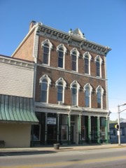 Hagerstown I.O.O.F. Halllisted 1978
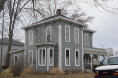 John & Caroline Stonebraker Houselisted 2014
Population over time
2 figuresHagerstown fell from 1,787 to 1,681 between 2010 and 2020. These are the recorded population figures Wikidata holds for this place, reached through the Geographic Names Information System number this page is keyed on rather than by name, so they belong to this place and not to another of the same name. Most are census counts, but not all are: an early figure may be a founding or settlement estimate, and an estimate published within five years of a census is left out. The change column is computed, and is left blank where more than 20 years separate a figure from the one before it, because a gap that long is not a change between two counts.
| Year | People | Change |
|---|---|---|
| 2010 | 1,787 | |
| 2020 | 1,681 | -106 (-6%) |
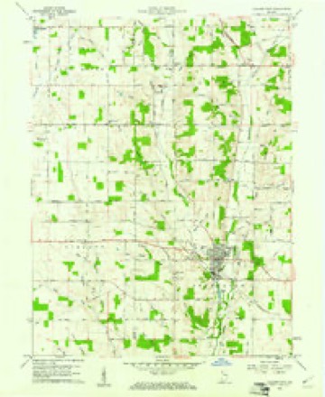
Topographic sheets covering this place
4 surveys from 8 printed sheetsMatched by testing this settlement's coordinate against the published boundary of every sheet in the United States Geological Survey's historical collection. Each opens the scanned sheet at the Survey.
- 1953 USGS Cincinnati quadrangle1:250000, 3 printings
- 1957 USGS Cincinnati quadrangle1:250000
- 1960 USGS Hagerstown quadrangle1:24000, 2 printings
- 1986 USGS New Castle quadrangle1:100000, 2 printings



In the county-history sources
5,660 words on this townshipHistory of Wayne County, Indiana : Together with Sketches of Its Cities, Villages and Towns, published 1884 names this settlement in its chapter on Jefferson Township. These are the passages that mention it, exactly as the scans read.
Jefferson Township lies on the west line of the county, and north of the central part. It is bounded on the north by Dalton and a part of Perry townships; on the east, by Perry, Clay and Harrison; south, by Harrison and Jackson, and west by Henry County. It is six miles east and west, and five miles north and south less two sections on the south tier in the southeast corner of the township. This gives it twentyeight square miles of land, or in acres, 17,920. Of this number of acres 17,162.78 is found on the assessment roll without counting Hagerstowti, and is assessed as follows: Eeal estate, 1882, $658,995; personal property, $264,623, a total of $923,578. Hagerstown, realty, $133,990; Hagerstown, personal, $85,720; total valuation of township, $1,143,288. The township poll number," 198 ; Hagerstown poll number, 164; total vote, 362.
Passage source: History of Wayne County, Indiana : Together with Sketches of Its Cities, Villages and Towns, published 1884.
The township was organized in March, 1834, and the voting precinct was located at Hagerstown. It is a good agricultural township, well watered, and in the valleys of the streams coursing through its territory can be found a superior quality of arable land, in fact unsurpassed anywhere. The West Branch of the Whitewater nearly divides it in two equal parts, running as it does nearly through the center of the township from north to south. On the east is Martindale's Creek, flowing in a southerly course, and on the west Nettle Creek, coming into the township near the northwest corner and flowing in a southwesterly course, empties into the "West Branch. Below this are two other small streams flowing into the West Branch. Thus it may be said to be well watered, and a fine stock-raising section.
Passage source: History of Wayne County, Indiana : Together with Sketches of Its Cities, Villages and Towns, published 1884.
The years in which most of the early settlers made their settlements, is not remembered, says " Young's History," by any of the oldest inhabitants. As the sales of the lands west of the Twelve Mile Purchase did not commence until 1822, it is presumed that most of the early settlements were made in the eastern part of the township, many of them soon after the peace of 1814-'15. Some, however, settled on the west side of the line of the Purchase several years before the lands were offered for sale. Samuel Baldridge, from Kentucky, unmarried, settled, in January, 1814, three miles east of Hagerstown, and was one of the earliest settlers in Jefferson Township. Jonathan Platts, from New Jersey, settled early one and one-half miles southeast of town. He was an early Justice of the Peace, and at several sessions President of the Board of Justices, which, from 1824 to 1828, was substituted for the three county commissioners; and from 1829, for several years, a county commissioner. Philip Baltimore settled early one tnile east of the town. Isaac Pierce, from Tennessee, settled one and one-half miles northeast from Hagerstown.
Passage source: History of Wayne County, Indiana : Together with Sketches of Its Cities, Villages and Towns, published 1884.
Machine-read from a century-old scan, so expect the errors a machine makes: misspelled names, dropped words, stray characters.
Read the whole chapter on Jefferson Township - it names this place 18 more 18 times.
Mines and quarries near this place
1 within 5 milesRegional context, not property-specific evidence. The federal mineral resources record lists 1 working within 5 miles of Hagerstown: 1 producer. All of them still produce. What was taken out: Sand and Gravel, Construction. Distance is straight-line from the map coordinates, so a quarry counted here may appear on a neighbouring settlement's page as well.
| Where | Site | Commodity | Status | Recorded |
|---|---|---|---|---|
| House Gravel Pit | Sand and Gravel, Construction | Producer |
Storms near this place
39 since 1993Regional context, not property-specific evidence. The National Weather Service names Hagerstown in 39 storm reports between 1993 and 2026: 31 thunderstorm wind, 7 hail, 1 lightning. No death or injury is recorded in these reports. Each account below is quoted exactly as the forecast office filed it, from the NOAA Storm Events Database, and each date opens the federal record of that event.
| When | Event | Place named | Harm | What the report says |
|---|---|---|---|---|
| July 2003 | Thunderstorm Wind | Hagerstown | $10,000 | A sign was blown off a hardware store, and a few trees were downed. |
| June 2005 | Thunderstorm Wind | Hagerstown | $8,000 | Numerous trees were knocked down across the northern part of the county. |
| June 2008 | Hail | Hagerstown | $8,000 | no account filed |
| July 1995 | Thunderstorm Wind | Hagerstown | $6,000 | Trees were downed, at least on a car. |
| May 2006 | Hail | Hagerstown | $6,000 | no account filed |
| November 2013 | Thunderstorm Wind | Hagerstown | $5,000 | A tree was downed on Dalton Road in Hagerstown due to thunderstorm winds. Trees were also downed in Mount Auburn and Cambridge. Wires were reported down in Richmond. |
| April 2000 | Thunderstorm Wind | Hagerstown | $5,000 | Trees were knocked down across Jerry Myers Road. |
| June 2000 | Thunderstorm Wind | Hagerstown | $5,000 | Trees and power lines were downed. |
| July 1999 | Thunderstorm Wind | Hagerstown | $5,000 | Trees were knocked down by a 70 mph wind gust. |
| April 1993 | Thunderstorm Wind | Hagerstown | $5,000 | Utility poles were downed. |
| June 1996 | Thunderstorm Wind | Hagerstown | $5,000 | no account filed |
| March 2025 | Thunderstorm Wind | Hagerstown | $3,000 | Multiple trees were downed in Hagerstown. |
| May 2015 | Thunderstorm Wind | Hagerstown | $3,000 | A tree was uprooted and damage occurred to an exterior porch addition. |
| August 2010 | Thunderstorm Wind | Hagerstown | $3,000 | Large trees and power lines were reported down throughout the county. |
| April 2006 | Thunderstorm Wind | Hagerstown | $3,000 | Power lines were knocked down. |
| June 2006 | Thunderstorm Wind | Hagerstown | $3,000 | Large tree limbs and power poles were downed. |
| October 2006 | Thunderstorm Wind | Hagerstown | $3,000 | Trees were knocked down. |
| July 2005 | Thunderstorm Wind | Hagerstown | $3,000 | Two trees and a large limb were downed across the central portion of the county. |
| September 2005 | Thunderstorm Wind | Hagerstown | $3,000 | Several trees were downed. |
| July 2001 | Thunderstorm Wind | Hagerstown | $3,000 | Roof was peeled off of a barn |
| June 1999 | Thunderstorm Wind | Hagerstown | $3,000 | A severe thunderstorm produced winds that knocked down several trees. |
| July 1999 | Thunderstorm Wind | Hagerstown | $3,000 | Trees downed. |
| March 1997 | Thunderstorm Wind | Hagerstown | $3,000 | no account filed |
| April 2026 | Thunderstorm Wind | Hagerstown | $2,000 | A few power lines were downed. |
| March 2025 | Thunderstorm Wind | Hagerstown | $2,000 | A tree was downed onto a power line. |
| February 2006 | Thunderstorm Wind | Hagerstown | $2,000 | Two trees were downed. |
| June 2025 | Thunderstorm Wind | Hagerstown | $1,000 | A tree was downed on State Route 1. |
| July 2022 | Thunderstorm Wind | Hagerstown | $1,000 | A large tree was downed on Washington Street. |
| June 2018 | Lightning | Hagerstown | $1,000 | A tree was hit and knocked down by a lightning strike. |
| April 2016 | Thunderstorm Wind | Hagerstown | $1,000 | A tree was knocked down near the intersection of Hoover Rd. and Lacy Rd. |
| August 2015 | Thunderstorm Wind | Hagerstown | $1,000 | One tree was knocked down along W.E. Oler Road and Lacy Road. |
| October 2013 | Thunderstorm Wind | Hagerstown | $1,000 | A large limb was reported down northwest of Hagerstown due to thunderstorm winds. |
| May 2011 | Thunderstorm Wind | Hagerstown | $1,000 | A tree was reported down on a road due to damaging thunderstorm winds. |
| August 2021 | Thunderstorm Wind | Hagerstown | $250 | Several large tree limbs were downed on Olive Branch Road. |
| May 2011 | Hail | Hagerstown | - | no account filed |
| August 2009 | Hail | Hagerstown | - | no account filed |
| April 2006 | Hail | Hagerstown | - | no account filed |
| April 1998 | Hail | Hagerstown | - | no account filed |
| May 1998 | Hail | Hagerstown | - | no account filed |
Nearest settlements
The eight closest, with where each one stands in the county. Distances are straight-line, computed from the Geographic Names Information System coordinates.
| Map | Place | Distance | Sheets |
|---|---|---|---|
| Franklin | 4.6 miles | 8 | |
| Jacksonburg | 5.0 miles | 9 | |
| Dalton | 5.1 miles | 8 | |
| Economy | 6.0 miles | 8 | |
| Hoover Mill | 6.1 miles | 9 | |
| Greens Fork | 6.5 miles | 8 | |
| Cambridge City | 6.8 miles | 8 | |
| East Germantown | 6.9 miles | 8 |
Elsewhere
Matched on this settlement's Geographic Names Information System number rather than its name, so it cannot be a different place of the same name in another state.
| Wikipedia article on Hagerstown | An encyclopaedic summary. Its text is share-alike, so it is linked here rather than copied. |
| Wikidata item Q2802507 | The structured record the population and elevation above come from. Public domain (CC0). |
Provenance
This settlement is recorded in the Geographic Names Information System as feature 452048. The sheet list is computed by point-in-boundary test against the United States Geological Survey's historical topographic inventory. Both are works of the United States government and carry no copyright under 17 U.S.C. 105.
Mines and quarries. USGS Mineral Resources Data System (MRDS) https://mrdata.usgs.gov/mrds/ A work of the United States government, no copyright under 17 U.S.C. 105.
Storms. NOAA National Centers for Environmental Information, Storm Events Database https://www.ncei.noaa.gov/stormevents/ A work of the United States government, no copyright under 17 U.S.C. 105. Narratives are quoted verbatim from the National Weather Service report and are not edited or summarised.