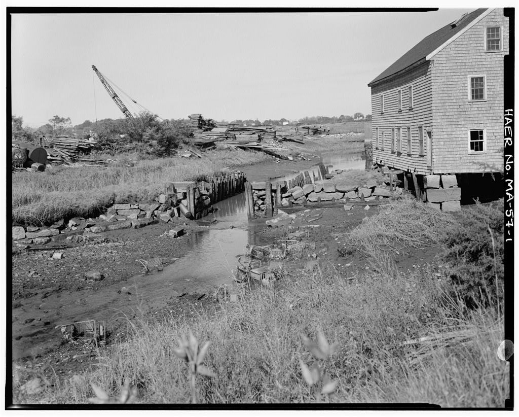
Souther Tide Mill Dam, 610 Southern Artery, Quincy, Norfolk County, MA. Surveyed as HAER MASS,11-QUI,11-, with 1 photograph and a 4,250-word written history.
From the record
“The Souther Tide Mill Dam is significant as a relatively well-preserved example of a once common and now rare type of mill dam.”
Written record, HAER MASS,11-QUI,11- survey. Machine-read text.
surveyed by the federal HAER program as HAER MASS,11-QUI,11- · the record runs 4250 words · one of 94 surveyed structures published for this county.
Source document
Quoted word for word from HAER MASS,11-QUI,11-.
Not written, edited or summarised by this site.
The Souther Tide Mill Dam is significant as a relatively well-preserved example of a once common and now rare type of mill dam. Built ca. for Ebenezer Thayer, it is associated with the Souther Tide Mill which is one of two tide mills in Massachusetts and one of the less than ten tide mills that remain on the Atlantic seaboard. The Souther Dam is also a significant structure in the industrial history of Quincy both as part of the oldest standing mill complex in the city and as the best-preserved element of the Quincy Canal The dam and its tide lock were major components of the efforts made to improve navigation on the Town River and thereby facilitate the transportation of granite from the Quincy quarries.
The dam's granite block masonry is also a significant example of the manner in which the people of Quincy employed their most abundant natural resource, granite, in a wide range of buildings and structures. SOUTHER TIDE MILL DAM HAER NO. MA-57 (Page 2 ) Project Description; The major features of the project are the construction of a 4060-foot-long relief tunnel under downtown Quincy, improvements to the Town River channel below the tunnel outlet and reconstruction of the Old Quincy Dam. It is presently planned under the Town River improvements phase of the project to relocate the channel along the left bank and provide gabion slope protection. Implementation of the above wall requires the removal of the dam associated with the Souther Tide Mill. SOUTHER TIDE MILL DAM HAER No.
MA-57 (Page 3 ) PART 1 -
History of the Souther Tide Mill Dam
On June the Massachusetts Legislature passed an act authorizing Ebenezer Thayer, a merchant of Boston and Charlestown, to erect a mill dam across the Town River in Quincy. 1 Thayer, who moved to Quincy shortly thereafter, had assembled a thirty-nine acre tract along Town River and Town River Bay beginning in when the area was mostly saltmarsh and meadow. He first built two wharves on the Town River Bay east of the river and between and he erected a dam across the Town River and a grist mill on the east bank. This was not the first tidemill in Quincy; two earlier tide mills had been built on Black's Creek.
Nor was it the only grist mill in town; a grist mill on Town Brook had been established in the seventeenth century and continued to operate, intermittently, up into the 2 In Thayer sold two parcels totaling fifty-four acres and including the grist mill, dam and mill pond, to David Stetson, a Charlestown merchant, for 3 Less than a year later, on May 16, Stetson conveyed the same property to John Souther of Hingham, a shipwright. 4 Souther had apprenticed with his father as a shipwright in Hingham and became a partner in the family shipyard in 5 In he moved to Quincy and established his own shipyard on his new property, with a wharf and a dock on Town River Bay, east of the tide mill. Souther and his son, John L.
Souther operated this shipyard for nearly fifty years, building many important vessels, including sloops and schooners that carried Quincy granite up and down the Atlantic seaboard. Souther also became prominent in town affairs, serving as Quincy's representative in the state legislature for five years. Although shipbuilding was his principal occupation, Souther continued to operate the grist mill and built a tide-powered saw mill next to it. The growth of the Quincy granite quarrying industry in the led to a major change in the Town River and the tide mill dam. In order to facilitate transportation of the heavy granite blocks from Quincy to their SOUTHER TIDE MILL DAM HAER No.
MA-57 (Page 4 ) various destinations, a group of investors formed the Quincy Canal Corporation with the aim of making the Town River navigable for stone sloops and schooners up to the head of tidewater at what is now Washington Street in Quincy center. Planning began in the spring of with James Baldwin, son of Loammi Baldwin and member of the prominent family of Massachusetts engineers, supervising the endeavor.
The project, which consisted of dredging a channel in the river, raising up the banks, building a towpath on the western bank and constructing a lock in the Souther mill dam.was completed in the fall of at a cost of 7 In January, Souther formalized an agreement with the Quincy Canal Corporation in which he granted the corporation the right of free passage through the mill and the corporation in turn agreed to keep the lock, abutment and dam in proper repair. Souther retained full use of the pond for his mill and the corporation was to reimburse him, at the rate of $20 per month, if the canal needed to be drawn off for repairs or if more than six inches were to be drawn off the pond by boats locking in or out of the canal.
8 The Quincy Canal appears to have been a technical success, in that it enabled vessels to come within a mile of the North Common quarries and thereby reduced the trouble and expense of transporting the stone. However, like the tide mill, the canal was operable for only two short intervals every twenty-four hours. Although the canal continued to operate for many years before the corporation failed in it was never a financial success, unlike the nearby Granite Railway, also built in for the purpose of carrying stone from the West Quincy quarries to the Neponset River. 9 The Southers added the operation of the tide lock to their shipbuilding and milling activities.
John Souther's oldest son, Henry ran the mill in the and into the He was succeeded for a time by Souther's youngest son, Edward who built a new grist mill, the present mill building, in to replace the earlier mill which was destroyed by fire. It was probably at this time that the mill was equipped with turbines. By the Southers had leased the grist mill to Joseph Loud, who had a feed and grain store near the Quincy railroad depot. The mill, which by then was the only grist mill in Quincy, had two runs of stones SOUTHER TIDE MILL DAM HAER No. MA-57 (Page 5 ) and was capable of producing 500 bushels of grain a day. 10 In the Southers sold one part and leased another part of the shipyard and wharf to Wilber F.
Lakian, who, in company with several Maine lumber merchants, converted the property into a lumber yard. The Lakian Company built a steam-powered saw and planing mill on their property east of the tide mills. 11 John L. Souther, who purchased the other family interests in the mills for in finally sold the tide mill property in to the Maine lumber merchant, Benjamin Johnson. '* Johnson, who had been one of Lakian's partners, bought the Lakian Company property in and moved from Bangor to Quincy. He improved the lumberyard, expanding the capacity of the sawmill and building new lumber houses. Beginning with Johnson's tenure, the grist mill ceased to operate and was used thereafter as a storage building.
No definite record exists as to when the lumber company stopped using the tidal power of the river in the sawmill. Most likely water power remained an option into the early twentieth century. The accompanying photograph of the mil! and dam from the Parker Collection of the Thomas Crane Public Library in Quincy shows only one of the two tide gates in place, indicating that the water-power system was no longer functional. The property remained a lumber yard after Johnson's death in The Quincy Lumber Company acquired the lumber yard from a group of interim owners led by Benjamin Pope in and operated the yard for seventy years, finally shutting down in '3 Since that time, the lumber yard has remained vacant. A flood abatement project by U.S.
Army Corps of Engineers will necessitate the destruction of much of the mill dam in the near future. PART 2 -
Description of the Souther Tide Mill Dam
The Souther Tide Mill Dam, a granite block structure with earth-filled abutments, is built across the Town River approximately ninety-two A meters upstream (south) of the river's confluence with Town River Bay in w Quincy, Massachusetts. The Souther Tide Mill, a two-story, gable-roof, frame building, is located at the east end of the dam, resting partly on the SOUTHER TIDE MILL DAM HAERNo. MA-57 (Page 6) granite block wall that lines the eastern river bank and partly on a granite block pier and a granite block foundation wall on the dam's eastern abutment. The Town River is a tidal waterway that extends inland in a westerly direction about a mile across the alluvial Quincy Plain.
'^ At the head of tidewater at Washington Street in Quincy center, Town Brook, a small freshwater stream, feeds into the river. The river's waters rise and fall with the nine-foot tide; at low tide the muddy river bed is exposed except for the small flow of water from Town Brook. The area at the mouth of the Town River was outside the compact settlement at Quincy center and up until the beginning of industrial activities here in the early nineteenth century, the relatively level terrain was mostly covered with saltmarsh and meadow. A major transformation -of the area began between and when Ebenezer Thayer erected two wharves on the bay and built a dam across the river and a grist mill on the east bank.
Thayer's activities set a pattern of land use that persisted up to the present with few changes. From to the Souther shipyard occupied the property on the east bank; from to there was a succession of lumber companies on the site. The shipyard and the lumber companies had similar patterns of land use, with a main wharf on the bay, the milling operations and a smaller wharf on the river bank, various other buildings located throughout the site and a large amount of open land in between, used either for shipbuilding or storing and curing lumber.
Although the property has been idle since the Quincy Lumber Company ceased operations in the physical plant, which consists largely of frame buildings from the late nineteenth and early twentieth centuries, as well as the grist mill, is little changed. The dam is in relatively good condition though its woodwork is badly deteriorated. The area on the west bank of the river was developed less intensively in the nineteenth century. For the most part it remained open land used for lumber and coal yards. Duane's salvage yard presently occupies the site. The construction of the Southern Artery (U.S. Route 3-A) after World War II had a major impact on the area.
This four-lane divided highway, which roughly parallels the shoreline of Town River Bay, crosses Town River on a concrete slab bridge approximately thirty-four yards south of the dam. In the course of the commercial development that followed the completion SOUTHER TIDE MILL DAM HAER No. MA-57 (Page 7 ) of the highway, most of the former millpond on what is now the south side of the highway was filled in and paved over. The mill dam is an dry-laid granite block structure, eight feet, five inches high, that extends sixty-nine feet from the western river bank across the river to the western side of the grist mill, where it ends at the raceway that runs under the mill.
The eleven-foot, nine-inch-wide opening for the tide gate on the western end of the dam is flanked by a pair of granite block piers, eight feet, five inches high; five feet, three inches wide; and seven feet deep. The eastern pier is set back three feet from the face of the eastern wing of the dam. The piers are built of long, roughly cut, random coursed blocks that exhibit the closely-spaced, round-bottomed drill marks characteristic of early-nineteenth-century quarrying. There are the remnants of three broken drills embedded in the capstone on the western pier. The double, swinging tide gates, hinged on the sides, one of which appears in the photograph of the dam, are no longer extant.
However, on the face of either pier, the heavy timber posts that supported the gates are still in place, as is the timber sill that runs across the opening. The posts are eight feet high and fourteen inches square and each is notched on the exposed inner corner. On both sides of the gate opening, the granite block dam was faced with wooden sheathing designed to increase its impermeability. This sheathing continued around the southeastern corner of the dam and met with the wooden framing that ran across the head race and contained the sluice gates. The timber sill, the stumps of the timber studs and a ragged fringe of the vertical sheathing boards running along the base of the masonry on the eastern side of the gate are all that remain of the dam sheathing.
A row of timber posts running across the head race under the mill marks the location of the sluice gates. The photograph of the mill and dam shows a small wooden deck that ran between the eastern end of the dam and the doorway in the southwest corner of the mill. The deck, which would have enabled the miller to reach the tide gates, has disappeared, though the doorway remains unchanged. On the upstream side of either gate pier there are also the remnants of low wooden walls set in the river bed that apparently served to keep back sand and silt that might impede the movement of the gates. These SOUTHER TIDE MILL DAM HAER No. MA-57 (Page 8 ) vertical-board walls rise approximately ten inches above the river bed.
The western river bank is a narrow (fourteen-and-a-half- to twenty-three-foot-wide) strip of land, with a short tidal inlet, thirty-nine-and-a-half-feet wide, on its western side that may have served as a lay-by for vessels waiting to pass up the canal. A drainage ditch that ran along the west side of the west bank and received the overflow water from the canal at high tide formerly flowed into this inlet. This ditch and the southern end of the inlet were filled in in the mid-twentieth century. The west bank was originally faced with random-coursed granite block masonry for fifty-four feet south of the gate pier with the stonework ending at a spillway that drained excess water from the mill pond into the small inlet.
A wooden deck ran along the top of the bank, carrying the canal towpath across the spillway. Presently, the stonework is intact for about half of the original length; the upper courses of stone in the southern half of the wall have tumbled down and the top of the earthen bank has slumped into the river. The spillway site is now marked by a wet depression in the bank and on top of the bank, two deteriorated wooden footings are all that remain of the wooden deck. On the downstream side of the dam there are two abutments, sixty-five-and-a-half feet long, which support the dam and form the sidewalls of the tidal lock chamber. The eastern abutment, also provides a base for the granite block foundations that support the western end of the mill.
The abutments are earth-filled, heavy-timber cribwork structures that terminate in granite block rip-rap at their northern ends. Erosion has carried away much of the fill on the inner faces of the abutments and has exposed elements of the timber cribbing. The most visible elements of the crib structures, which are essentially identical, are the two rows of vertical timber piles, set in timber sills in the lock chamber floor, that mark the sidewalls of the lock chamber. The piles, which are six feet, four inches high and seven inches square, may have been intended to serve as fenders as they are, or, more likely, they may have been covered with wooden sheathing which has since disappeared.
Originally, a horizontal timber stringer was attached by mortise and tenon to each post at approximately four feet above the chamber floor. Erosion and settling have caused the piles and stringers to separate. At its opposite end, each thirteen-and-a-half-foot-long stringer is pegged into a heavy timber sill, SOUTHER TIDE MILL DAM HAER No. MA-57 (Page 9 ) eleven inches square, with a single treenail. These upper sills rest on an earth foundation and both the sills and the stringers were originally covered with earth fill. Erosion has exposed part of the upper sill in the western abutment. The upper sill in the eastern abutment is still below the surface, covered by a four-inch-thick layer of blue-grey sterile clay that was probably laid during construction to seal out water.
The western abutment is formed solely by its earth-filled timber crib; in the eastern abutment, the timber crib is built into the earth bank on which the western end of the mill rests. This triangular bank in the southeast corner of the abutment is faced with random granite block masonry on the east side along the mill race. The lock chamber formed by the two abutments is twenty-two feet wide. It was built with a wooden floor, part of which is still in evidence between the gate piers at very low tide. There is also a granite sill running across the floor of the chamber at the northern end.
There is a dearth of evidence on the original appearance of the dam and tide mill or the identity of the workmen who built them sometime between and The nature of tide milling indicates that the operation included a dam across the river with a tide gate that opened to allow the flood tide upstream and then closed with the ebb tide, creating a mill pond in the river upstream. Once the tide had dropped sufficiently, the impounded waters were then released through sluice gates and turned the mill wheel or wheels as they flowed back into the river. In the early nineteenth century, tide wheels were undershot wooden wheels, rarely more than fifteen feet in diameter, with twelve to twenty-four floats.
This system enabled the miller to run his mill twice a day, for two to three hours at a time, though the duration depended on the size of the mill pond. The present complex occupies the site of the first mill and dam, though its appearance today reflects major changes that occurred in the course of two events: the construction of the Quincy Canal in and building of a new grist mill in after the original building burned. The canal construction had a major impact on the structure , while construction of the new mill apparently had little effect on the dam. The slight amount of information available on the canal construction indicates first, that a channel was dredged in the river bed and the banks SOUTHER TIDE MILL DAM HAERNo.
MA-57 (Page 10) were built up, with the west bank serving as the towpath; and second, that the canal corporation erected a "lock and abutment and dam" at the mill dam. On the upstream side of the dam, the canal corporation built up what is now the western bank in what had been saltmarsh so that it could serve as a towpath and as part of the dam. The corporation presumably built its lock onto the existing tide gate and added an abutment. If the language of the deed is precise and the company built only one abutment, it would indicate that the eastern crib was built into an earth, and perhaps rubble, abutment that was already in place, supporting the dam and the mill as it does today.
The tide gate may have been rebuilt to facilitate vessels' passage through the lock during times when the gates would ordinarily be closed for milling purposes. It was common practice to build tide mill dam gates so that they would open automatically for the flood tide and close in the same way for the ebb tide. This arrangement would not have accomodated boats that tried to leave the canal once the tide had begun to recede and there must have been provisions for operating the gates manually. The dam as it exists today appears to have been in place by certainly it is in the same configuration as the structure that appears in the and plans, which are the earliest known plans that show the site in any detail.
The Souther Tide Mill Dam is a distinctive product of the building conditions in nineteenth-century Quincy. Most early-nineteenth- century dams in the United States had either fteldstone or timber facing and earth and rubble fill. The proximity of the Quincy granite quarries to this site on the Town River made it relatively easy to build a more substantial dam out of large, quarried, granite blocks. The builders still had to sheath the masonry with wood to make it watertight, as there was no hydraulic cement available that could withstand the corrosive effects of saltwater. The advantages of being able to build a stone dam are particularly apparent today, for while the woodwork has deteriorated, the masonry has been little disturbed over one hundred and fifty years.
SOUTHER TIDE MILL DAM HAER No. MA-57 (Page 11 ) ENDNOTES 1. Chapter 6, Special Laws of the Commonwealth of Massachusetts.1806, 2. Norfolk County Land Records, Book 47, Page August H. Hobart Holly, "Town River, Tidemills and the Quincy Canal," Quincy History. Winter Quincy: Quincy Historical Society, Pp. 3. Norfolk County Land Records, Book 47, Page August 4. Norfolk County Land Records, Book 50, Page May 6, 5. William Pattee. A History of Old Braintree and Quincy. Quincy: P. 6. George Whitney, Some Account of the Early History and Present State of the Town of Quincv in the Commonwealth of Massachusetts. Quincy: P. 47. 7. ibid, p. 48; Holly, p. 2; D. Hamilton Hurd, History of Norfolk County. Massachusetts. Lewis & Co., P. Norfolk County Land Records, Book 78, Page July, 8.
Norfolk County Land Records, Book Page 47, January 6, 9. Holly, p. 2; Norfolk County Land Records, Book Pages 10. Norfolk County Land Records, Book Page April, Book Page December, Souther Family Entries in Vital Statistics of Quincy MS microfilm, Quincy Historical Society; Dorchester and Quincv Directory. Boston: D. Dudley & Co., Wevmouth. Quincy and Braintree Directory. Boston: D. SOUTHER TIDE MILL DAM HAERNo. MA-57 (Page 12) Dudley & Co., Souther Tide Mill Survey Report, Massachusetts Historical Commission. 11. Norfolk County Land Records, Book Page 37, June Book Page 19, 12. Norfolk County Land Records, Book Page January, Book Page October, Book Page September 21, 13. Norfolk County Land Records, Book Page July Souther Tide Mill Survey Record, Massachusetts Historical Commission. 14.
William O. Crosby. Geology of the Boston Basin Vol. I. Part III. Boston: Boston Society of Natural History, P. 15. Norfolk County Land Records, Book 78, Page July 5, 16. "Plan of Land in Quincy Owned by Benjamin Johnson, May 20, Ernest W. Branch, Surveyor," Norfolk County Land Records Plan Book 47, Page 17. Martha and Murray Zimiles. Early American Mills. New York: Bramhall House Pp. William Fox, Bill Brooks and Janice The Mill. Boston: New York Graphic Society, P. 36. 18. Norfolk County Land Records, Book 78, Page July 5, Book Page 47, January 6, Whitney, p. 48. 19. T. Allan Comp and Kathleen Hoeft, Long Island Wind and Tide Mills. Washington: HAER, P. 2; Marion N. Rawson, Little Old Mills . New York: E.P. Dutton, P. 91. 20.
"Plan of Land in Quincy owned by Souther, Whitman, Surveyor, in Norfolk County Land Records Book Page "Plan of SOUTHER TIDE MILL DAM HAERNo. MA-57 (Page 13 ) Land in Quincy Owned by Benjamin Johnson, May Ernest W. Branch, Surveyor," Norfolk County Land Records Plan Book 47, Page 21. Zimiles and Zimiles, p. 7; Rawson, p. SOUTHER TIDE MILL HAER No. MA-57 (Page SOUTHER TIDE MILL DAM SITE PLAN TOWN RIVER QUINCY, MASSACHUSETTS SOUTHERN S ARTERY ) QUINCY LUMBER YARD KEY 0X0 - granite masonry ' - wooden posts & piles - wooden stringers & sills - frame mill building - mill tail race B - lock chamber C - towpath deck footings D - spillway site E - exposed cribbing SOUTHER TIDE MILL DAM HAERNo. MA-57 (Page 15 ) LOCK CHAMBER SKETCH PLAN KEY UU t tjf GX?
- granite masonry J i * *7 - wooden piles 1 / i / I mm - exposed wooden stringers GZB - conjectural stringers cnn - exposed upper sill LOCK CHAMBER c=3 -conjectural upper s3l SCALE SECTION A-] - A2 . Showing the relation between the timber crib and Souther Mill the western mill foundation in the eastern abutment A2 lower sill ADDENDUM TO: HAER MA-57 SOUTHER TIDE MILL DAM HAER MASS,11-QUI,11- 610 Southern Artery Quincy Norfolk County Massachusetts FIELD RECORDS HISTORIC AMERICAN ENGINEERING RECORD National Park Service U.S. Department of the Interior C Street NW Washington, DC
The original filed report, and the sheets the survey produced. Those published here appear above.
Also surveyed in Quincy
23 records
The federal surveyors worked through Quincy building by building. These are the other structures
they measured and filed a report on, longest report first.
 Block
Block