 Block
From the record
5 National Register listings published here.
Sources: the county history on the Internet Archive · the National Register database, National Park Service
59 topographic sheets cover 28 settlements here, and 5 properties are on the National Register of Historic Places.
5 National Register listings published here.
Sources: the county history on the Internet Archive · the National Register database, National Park Service
Every property in this county listed on the National Register of Historic Places, with the year it was listed and the federal nomination document.
| Photograph | Property | Type | Listed | Reference |
|---|---|---|---|---|
| Dr. Arthur W. Allen Home | building | 2020 | 100005966 | |
 | Fife Opera House | building | 1990 | 89002348 |
 | John B. Harper House | building | 2004 | 03001199 |
 | Palestine Commercial Historic District | district | 1995 | 95000985 |
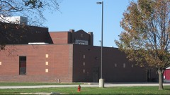 | Robinson High School Auditorium-Gymnasium | building | 2005 | 05000434 |
The NOAA Storm Events Database holds 281 reports for this county, causing 6 deaths, 12 injuries and about $6,902,100 in recorded property damage. Each settlement page carries the reports that name it.
| Kind of event | Reports |
|---|---|
| Thunderstorm Wind | 137 |
| Hail | 69 |
| Flash Flood | 43 |
| Tornado | 23 |
| Flood | 8 |
| Lightning | 1 |
The most serious of them, by death, then injury, then recorded damage. The accounts are quoted exactly as the forecast office filed them.
| When | Event | Place named | Harm | What the report says |
|---|---|---|---|---|
| March 2023 | Tornado (EF3) | Pierceburg | 3 killed, 8 hurt | This tornado crossed into western Crawford County from Jasper County at 9:03pm CDT. The tornado tracked northeastward, doing minor structural damage to a machine shed along County Highway 1 near Pierceburg. Numerous wooden power poles were snapped and heavy damage to trees was noted with tops sheared off about 30 feet above ground. Structural damage to homes of the EF1-EF2 variety occurred as the tornado moved across County Highway 15 where two single family homes sustained major roof damage. A mobile home was torn in half with its debris strewn about 20 yards in opposite directions. Trees, while sparse in this area, were sheared about 20-30 feet above the ground. Further east along County Highway 15, structural damage occurred to a large machine shed where a stationary semi-trailer blew into its west-facing wall causing the entire structure to fail. The debris from the large machine shed then blew into an old, poorly anchored single-family residence and caused exterior walls to slide off its foundation. Over the next 3 miles along the path of the tornado just before it reached the south side of Robinson, considerable tree damage was observed.||As the tornado tracked into the south side of Robinson, it narrowly missed a major oil refinery. The tornado destroyed two manufactured homes resulting in two fatalities as it crossed County Highway 9 near the interchange of East 900th Avenue and North 1200th Street. Damage to structures, trees, and wooden power poles was determined to be EF1-EF2.||Heavy structural damage (EF3) and an additional fatality were noted on the east side of Robinson near the interchange of State Highway 1 and East 1050th Avenue where a two-story masonry building experienced failure to its top story walls. The adjacent properties also experienced heavy damage where the exterior walls of two |single-family homes collapsed. Damage to trees and utility poles in this area was extensive due to the amount of debris strewn toward the northeast. ||The tornado then moved over Robinson Municipal Airport, destroying airport hangers and a small outbuilding. The progressive collapse of the rigid frames of the metal building systems, which included steel beams measuring greater than 18 inches in diameter, caused the survey team to estimate EF3 damage at this point.||A continuous track of EF1 damage then extended northeastward across County Highway 5 where multiple single-family homes exhibited large sections of their roof structures removed. In addition, multiple large machine sheds experienced a collapse of their wall structures. ||The survey team concluded that the storm likely maintained its intensity as it tracked northeastward toward the Wabash River, noting about a quarter-mile wide swath of heavy tree damage to distant tree lines as it continued toward the river. The tornado then crossed the Wabash River into the National Weather Service Indianapolis County Warning Area (CWA) in western Sullivan County at 9:21pm CDT. |
| August 2000 | Flash Flood | Robinson | 3 killed, $1,000,000 | A cluster of thunderstorms persisted over mainly the far northern parts of the county into the overnight hours. Radar estimates indicated from 4 to over 5 inches of rain falling over a period of less than 6 hours. This resulted in flash flooding occurring in the far northwestern part of the county. A culvert went over its banks, resulting in an 80 foot long, 25 foot deep section of secondary roadway being washed away during the overnight hours. During the early morning hours, a female driver, unaware of the washout, drove off the roadway, into the hole. Shortly thereafter, a truck with two occupants went off the roadway as well. The truck stuck the car's gas tank, resulting in a fire. All three occupants were killed. A rail road bridge, 60 feet long, was also washed out completely in the area. |
| September 2000 | Flash Flood | Robinson | 1 hurt, $1,000,000 | Thunderstorms persisted during the daylight hours across the county. Ground saturated from the rainfall all day, eventually caused storm drains in Robinson to overflow and create widespread flooding and damage in much of the town. A local observer reported over 4.5 inches of rain during the event. Widespread basement and street flooding was noted. The hardest hit business in the city was a local Chevrolet dealership that sustained extensive damage to over 40 vehicles as well as the buildings on the lot. Water was reported nearly three and a half feet deep in the showroom of the dealership. Damage was noted to much of the building and its contents. The basement of a local health spa was reported as flooded, with several thousand dollars in damage. A building at WTYE-WTAY radio was reported to have water in it, but the station never went off the air. One injury was related to the event. A 20-year old male driver was involved in an accident on Illinois Route 33, just north of the Larwence county line. Water washed mud across the road, causing him to lose control of his car. He was taken to a local hospital complaining of neck and back pain. No other injuries were reported. |
| February 2026 | Tornado (EF1) | Hardinville | 1 hurt, $500,000 | The tornado began about three miles southeast of Hardinville, where it damaged several trees near the intersection of East 350th Avenue and North 825th Street. It then intensified to EF-1 as it moved northeast, severely damaging two homes including one mobile home that was thrown off its foundation and wrapped around a tree. An elderly woman in that mobile home was hospitalized with serious injuries. The tornado continued northeast, crossing several tree lines and damaging additional homes and farm buildings along 1125th Street and East 465th Avenue. After that, the tornado only produced minor tree damage. It eventually crossed State Highway 1 and dissipated about 2.5 miles north-northeast of Flat Rock. |
| May 1982 | Tornado (F0) | not stated | 1 hurt, $250,000 | no account filed |
| March 1984 | Thunderstorm Wind | not stated | 1 hurt | no account filed |
| May 2011 | Tornado (EF2) | New Hebron | $920,000 | A tornado touched down about 3 miles south of Robinson, and tracked to the northeast. Fourteen homes sustained damage, with three homes losing most of their roof and one home being pushed three feet off its foundation. In addition, numerous outbuildings and garages were destroyed, numerous trees and power poles were blown down, and a large camper was rolled over. |
| April 2006 | Thunderstorm Wind | Robinson | $775,000 | A swath of severe straight-line winds impacted the north side of Robinson. The damage swath started near the 1800 block of N. Argus St., and continued east-southeast, before ending near the 1300 block of N. Jackson St. These winds caused tree and roofing damage along the path, with the most significant damage noted toward the end of the swath. The high school and nursing home were among the structures damaged. One home and garage were destroyed by falling trees. A wind sensor at the high school measured a 65 knot wind gust. A 56 knot wind gust was measured 6 miles east of Robinson, but no significant damage was noted. |
| June 2008 | Flood | Bellair | $300,000 | Rainfall on June 6th, ranging from 5 inches in central Crawford County near Robinson to more than 9 inches in northeast Crawford County near West York and York, produced extensive flooding in much of the county. Nearly 50 homes in rural parts of northern Crawford County sustained flood damage. Most roads north of State Route 33 were under water from late on June 6th to the 13th. Crawford County was declared a disaster area due to the extensive flooding. |
| March 1983 | Tornado (F0) | not stated | $250,000 | no account filed |
| April 2006 | Thunderstorm Wind | Oblong | $120,000 | Two mile wide swath of damage between Oblong and Robinson. An airport hanger and four airplanes inside were destroyed at the Robinson Municipal Airport. Many trees, power poles and power lines blown down. A 24 foot trailer was blown over. No injuries were reported. |
| April 2020 | Thunderstorm Wind | Oblong | $100,000 | Numerous trees and power poles were blown down. |
| September 2014 | Thunderstorm Wind | Oblong | $100,000 | Several trees and tree branches were blown down, including some that fell onto houses and garages. A carport was blown over as well. |
| June 2011 | Lightning | Robinson | $100,000 | Lightning strikes from an isolated thunderstorm produced damage to electrical equipment and computers at the Crawford County 9-1-1 center, and at several nearby businesses and a church. |
| July 2010 | Thunderstorm Wind | Palestine | $85,000 | Several power lines and street signs were knocked down. 8 to 10 mature oak trees approximately 2 to 3 feet in diameter were toppled. Numerous tree branches were blown down all around town. |
| August 2009 | Thunderstorm Wind | Hutsonville | $75,000 | Numerous tree limbs were blown down across Hutsonville. In addition...roof, siding, and awning damage was reported to around a dozen homes. |
| June 2019 | Thunderstorm Wind | Robinson | $70,000 | Numerous trees and power poles were blown down in Robinson. The doors and a couple windows of the courthouse were blown out. Damage occurred to the Bradford Supply building. |
| June 2008 | Thunderstorm Wind | Palestine | $70,000 | A large metal pole building was destroyed. Also, a barn and several other outbuildings sustained damage. Corn was flattened in some area fields. |
| June 2016 | Thunderstorm Wind | Hutsonville | $65,000 | Numerous power poles were snapped about 3 miles northwest of Hutsonville. |
| April 2020 | Thunderstorm Wind | Robinson | $60,000 | Numerous trees and power poles were blown down. |
| May 2018 | Thunderstorm Wind | Robinson | $50,000 | Numerous trees and tree branches were blown down across Crawford County. |
| May 2016 | Thunderstorm Wind | Trimble | $50,000 | Several trees and power lines were blown down and a barn was damaged about two miles east of Trimble. |
| April 1994 | Tornado (F0) | not stated | $50,000 | Numerous trees were blown down shortly before a small tornado touched down. The tornado overturned a travel trailer and uprooted eight to ten trees. Some of the trees fell onto homes. |
| July 2016 | Thunderstorm Wind | Oblong | $45,000 | Several trees and power lines were blown down west of Oblong. |
| June 2011 | Thunderstorm Wind | Robinson | $45,000 | Numerours tree limbs and power lines were blown down in Robinson. |
| June 2019 | Thunderstorm Wind | Annapolis | $40,000 | Numerous trees and power lines were blown down across the northern half of Crawford County. |
| July 2016 | Thunderstorm Wind | Robinson | $40,000 | Several trees and power lines were blown down. |
| May 2014 | Thunderstorm Wind | Robinson | $40,000 | Large tree branches were blown down into power lines in Robinson. |
| June 2010 | Thunderstorm Wind | West York | $30,000 | Numerous large tree limbs and power lines were blown down southwest of West York and in and around Robinson. In addition, several carnival booths and a camper were overturned at a carnival in Robinson. |
| June 2016 | Thunderstorm Wind | Hutsonville | $25,000 | Numerous trees were blown down in Hutsonville. |
| May 2016 | Thunderstorm Wind | Palestine | $25,000 | Several trees and power lines were blown down in Palestine. |
| May 2011 | Thunderstorm Wind | Oblong | $25,000 | A large tree and several powerlines were blown down north of Oblong. In addition, a large storage shed was damaged. |
| June 2010 | Thunderstorm Wind | Robinson | $25,000 | A roof was blown off a mobile home south of Robinson. Also, numerous trees and power lines were blown down in and around town. |
| June 1990 | Tornado (F1) | not stated | $25,000 | no account filed |
| June 1990 | Tornado (F1) | not stated | $25,000 | no account filed |
| March 1976 | Tornado (F1) | not stated | $25,000 | no account filed |
| April 1972 | Tornado (F1) | not stated | $25,000 | no account filed |
| February 1959 | Tornado (F1) | not stated | $25,000 | no account filed |
| December 2015 | Thunderstorm Wind | Robinson | $20,000 | Several trees and tree branches were blown down in Robinson. |
| September 2014 | Thunderstorm Wind | Pierceburg | $20,000 | A grain delivery system was blown over and damaged. |
| April 2011 | Thunderstorm Wind | Landes | $20,000 | A metal roof was torn off a house in Landes. |
| July 2010 | Thunderstorm Wind | Robinson | $20,000 | Numerous trees and tree branches were blown down around Robinson. |
| October 2010 | Thunderstorm Wind | Robinson | $20,000 | Numerous trees and tree branches were blown down in Robinson. |
| June 2009 | Thunderstorm Wind | Robinson | $20,000 | Tree limbs were blown down on Clearwater Street in Robinson, causing a small fire to a storage building. |
| August 2009 | Thunderstorm Wind | Bellair | $20,000 | Several trees were blown down along E 2000th Ave from Bellair to Annapolis. |
| February 2008 | Thunderstorm Wind | Oblong | $20,000 | Numerous trees and power lines were blown down between Oblong and Robinson. |
| June 2008 | Thunderstorm Wind | West York | $18,000 | A trailer was flipped over. |
| June 2008 | Thunderstorm Wind | West York | $18,000 | Numerous tree limbs were blown down. In addition, an unsecured mobile home was rolled off its blocks. |
| April 2020 | Thunderstorm Wind | Flat Rock | $15,000 | A tree was blown onto a house in Flat Rock. |
| April 2017 | Thunderstorm Wind | Oblong | $15,000 | The roof of a business was damaged in Oblong. |
| July 2016 | Thunderstorm Wind | Oblong | $15,000 | Trees were blown down in Oblong. |
| May 2015 | Thunderstorm Wind | Palestine | $15,000 | Numerous trees were blown down, causing a power outage in Palestine. |
| June 2010 | Thunderstorm Wind | Oblong | $15,000 | Several power poles were blown down along North 25th Street just north of Oblong. |
| June 2008 | Flash Flood | West York | $15,000 | IL Route 1 was closed just south of West York because a large section of pavement had washed out at Raccoon Creek. |
| June 1998 | Thunderstorm Wind | Robinson | $15,000 | Thunderstorm winds damaged a barn and blew down several trees 2 miles southeast of Robinson. Debris from the barn caused minor damage to two mobile homes in the area. In Palestine, the winds blew down a tree which fell onto a mobile home causing minor damage. No injuries were reported and damage was estimated around $15,000. |
| July 1995 | Thunderstorm Wind | Countywide | $15,000 | Numerous trees and a few power lines were blown down across the county. |
| July 2016 | Thunderstorm Wind | Robinson | $12,000 | Several trees were blown down just south of Robinson. |
| June 2011 | Thunderstorm Wind | Oblong | $12,000 | Trees were blown down in Oblong. |
| January 2008 | Thunderstorm Wind | Hutsonville | $12,000 | Several trees and power lines were blown down between Hutsonville and Robinson. |
| April 2017 | Thunderstorm Wind | Oblong | $10,000 | Numerous trees were blown down on a property on the northeast side of Oblong. |
The Survey's mineral resources record lists 7 workings inside this county. 2 still produce and 5 are closed or unrecorded. Each settlement page carries the workings within five miles of it.
| Commodity | Workings |
|---|---|
| Sand and Gravel, Construction | 4 |
| Clay | 1 |
| Stone | 1 |
| Stone, Crushed/Broken | 1 |
The least common of them first, because a county's hundredth gravel pit says nothing its first ten did not.
| Where | Site | Commodity | Status | Recorded |
|---|---|---|---|---|
| Goodhope Shale Exposure | Clay | Prospect | ||
| Limestone Prospect | Stone, Crushed/Broken | Occurrence | ||
| Robinson City Eng. Pit | Stone | Past Producer | ||
| Crawford S & G East Dredge | Sand and Gravel, Construction | Past Producer | ||
| Crawford S & G South Dredge | Sand and Gravel, Construction | Past Producer | ||
| Lawrence Gravel #2 | Sand and Gravel, Construction | Producer | ||
| Turner Dredge | Sand and Gravel, Construction | Producer |
ILLINOIS HISTORICAL CRAWFORD COUNTY devotes a chapter to each township: its boundaries and streams, who settled it and when, the mills, the schools and the churches. All 8 are reproduced here in full. Each row shows the township's own shape and where it lies in the county, drawn from the Census Bureau's boundary. Which settlements belong to which township is computed from that same boundary, not taken from the book.
| Shape and position in the county | Township | Settlements in it | Length | Sections |
|---|---|---|---|---|
| Honey Creek Township | Duncanville, Flat Rock, New Hebron, Port Jackson, Villas | 343 words | 0 | |
| Hutsonville Township | Hutsonville, West York | 546 words | 0 | |
| Lamotte Township | Palestine, Richwoods, Trimble | 364 words | 0 | |
| Licking Township | Bellair, Kibbie | 1,102 words | 0 | |
| Montgomery Township | Crawfordsville, Heathsville, Morea, Oil Grove | 1,452 words | 0 | |
| Oblong Township | Dogwood, Oblong, Oil Center, Stoy | 1,216 words | 0 | |
| Prairie Township | Annapolis, Porterville | 125 words | 0 | |
| Robinson Township | Gordon, Robinson | 1,391 words | 0 |
One book written about this county, cut here where the book itself is cut, at its printed chapters: 16 chapters in all. Every chapter is public domain, machine-read from the scan and reproduced complete. A chapter already given under one of the county's towns is not repeated in this list.
| Chapter | Length |
|---|---|
| Chapter 1: Introductory | 982 words |
| Chapter 2: First Settlement - County Organizations | 1,970 words |
| Chapter 3: A Period of Transition | 771 words |
| Chapter 4: 'courts - Bench and Bar | 5,571 words |
| Chapter 5: Industrial Development | 1,115 words |
| Chapter 6: Official and Political | 1,109 words |
| Chapter 8: Towns and Villages | 3,476 words |
| Chapter 9: Early Churches - Fraternities | 3,570 words |
| Chapter 10: Educational | 1,217 words |
| Chapter 11: The Press | 1,057 words |
| Chapter 12: Crawford County Medical Society | 508 words |
| Chapter 13: Agricultural Society and Fairs | 4,313 words |
| Chapter 14: War History | 2,023 words |
| Chapter 15: The Oil Industry in Illinois | 9,652 words |
| Chapter 16: The Hutson Family Tragedy | 2,323 words |
| Chapter with an unread heading (no. 17 of those read) | 167,426 words in 11 parts |
Named settlements recorded in the Geographic Names Information System, each with the topographic sheets covering it. Villages, hamlets and abandoned places alike. Each is shown with the nearest named watercourse or landform and the survey quadrangle it falls on.
Montgomery township · 62427 · On Sugar Creek · Birds quadrangle
13 sheets, 1917 to 1986
No longer a settlement
Martin township · 62449 · On Freeport Creek · Oblong South quadrangle
13 sheets, 1910 to 1986
Montgomery township · 62427 · On Sweet Creek · Heathsville quadrangle
15 sheets, 1917 to 1986
Hutsonville township · 62433 · On Hutson Creek · Hutsonville quadrangle
14 sheets, 1953 to 1986
Honey Creek township · 62454 · On West Branch Honey Creek · Flat Rock quadrangle
13 sheets, 1917 to 1986
Martin township · 62449 · On Little Creek · Oblong South quadrangle
13 sheets, 1910 to 1986
Prairie township · 62454 · On Elm Creek · Porterville quadrangle
14 sheets, 1953 to 1998
Hutsonville township · 62478 · On South Fork Raccoon Creek · West Union quadrangle
14 sheets, 1953 to 1998
The vanished settlements of Crawford County: the places named above that are no longer on the map.