 Block
From the record
11 National Register listings published here.
Sources: the county history on the Internet Archive · the National Register database, National Park Service
60 topographic sheets cover 28 settlements here, and 11 properties are on the National Register of Historic Places.
11 National Register listings published here.
Sources: the county history on the Internet Archive · the National Register database, National Park Service
Every property in this county listed on the National Register of Historic Places, with the year it was listed and the federal nomination document.
| Photograph | Property | Type | Listed | Reference |
|---|---|---|---|---|
 | Alexis Opera House | building | 1987 | 87001267 |
| Brewer, May (Carns) and John E., House | building | 2023 | 100009641 | |
 | Carr House | building | 1988 | 88001229 |
 | Colwell, E. B., and Company Department Store | building | 1993 | 92001851 |
 | Sarah Martin House | building | 1980 | 80001414 |
 | Monmouth Courthouse Commercial Historic District | district | 2006 | 05001604 |
 | Patton Block Building | building | 1990 | 90001727 |
 | Pike-Sheldon House | building | 1999 | 99000976 |
 | Ivory Quinby House | building | 1980 | 80001415 |
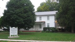 | Minnie Stewart House | building | 1989 | 89001733 |
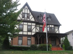 | William S. Weir Jr. House | building | 1992 | 92001004 |
Every wildfire the federal occurrence database records inside this county: 21 of them, burning about 146 acres. None started naturally and none was recorded as arson. Each settlement page carries the fires within five miles of it.
| Reported cause | Fires |
|---|---|
| Debris and open burning | 18 |
| Equipment and vehicle use | 2 |
| Smoking | 1 |
The five largest, by the area the report gives. None of them was recorded as arson.
| Date | Cause | Size | Reported by | Name on the report |
|---|---|---|---|---|
| 5 April 2013 | Debris and open burning | 37 acres | Illinois Division of Forestry Resources | 201327 |
| 6 April 2013 | Debris and open burning | 19 acres | Illinois Division of Forestry Resources | 201329 |
| 11 April 2014 | Debris and open burning | 16 acres | Illinois Division of Forestry Resources | 2014-242 |
| 27 October 2013 | Debris and open burning | 12 acres | Illinois Division of Forestry Resources | 201370 |
| 11 April 2014 | Debris and open burning | 12 acres | Illinois Division of Forestry Resources | 2014-244 |
| 9 April 2014 | Smoking | 9.0 acres | Illinois Division of Forestry Resources | 2014-235 |
| 4 April 2013 | Debris and open burning | 7.0 acres | Illinois Division of Forestry Resources | 201326 |
| 5 September 2013 | Equipment and vehicle use | 7.0 acres | Illinois Division of Forestry Resources | 201353 |
Every settlement page carries the fires within five miles of it - see the settlement index below.
The NOAA Storm Events Database holds 302 reports for this county, causing 1 death, 1 injury and about $6,964,700 in recorded property damage. Each settlement page carries the reports that name it.
| Kind of event | Reports |
|---|---|
| Thunderstorm Wind | 160 |
| Hail | 75 |
| Tornado | 35 |
| Flash Flood | 19 |
| Flood | 7 |
| Funnel Cloud | 3 |
| Heavy Rain | 2 |
| Lightning | 1 |
The most serious of them, by death, then injury, then recorded damage. The accounts are quoted exactly as the forecast office filed them.
| When | Event | Place named | Harm | What the report says |
|---|---|---|---|---|
| September 1959 | Tornado (F2) | not stated | 1 killed, $250,000 | no account filed |
| July 2015 | Tornado (EF2) | Nemo | 1 hurt, $1,500,000 | An EF-2 tornado with winds estimated at 125 mph tracked about 6 miles from east of Monmouth through the town of Cameron before lifting. A maximum path width of 700 yards was estimated in Cameron. The tornado began at 713 pm CDT 1 mile southeast of Monmouth and lifted at 734 pm 2.2 miles east of Cameron. The most intense damage occurred in Cameron where at least 3 homes were unroofed, numerous garages and outbuildings were destroyed, and a large grain bin at the elevator was destroyed. |
| May 2003 | Hail | Monmouth | $2,000,000 | no account filed |
| May 2003 | Flash Flood | Monmouth | $1,000,000 | 6 inches water covering intersection of US 67 and 210th Ave |
| May 2003 | Hail | Countywide | $500,000 | Across southern half of county |
| May 2003 | Tornado (F1) | Youngstown | $300,000 | no account filed |
| August 2007 | Thunderstorm Wind | Kirkwood | $250,000 | Straight-line winds estimated to be around 100 mph blew down several large trees, ripped part of a roof off a house, displaced and dented several grain silos, and flattened numerous corn fields between Kirkwood, IL and Monmouth, IL. Some of the trees fell onto houses and other structures (EF Scale rating: EF1). |
| May 2003 | Thunderstorm Wind | Swan Creek | $250,000 | Grain bins down |
| March 2016 | Tornado (EF1) | Walnut Grove | $200,000 | A tornado moved from McDonough County into Warren County west of Prairie City. It traveled northeast across Warren County, affecting mainly farm outbuildings and trees before it moved into Fulton County. |
| July 2015 | Tornado (EF2) | Kirkwood | $150,000 | An EF2 tornado with maximum wind estimated at 120 MPH touched down 2.6 miles east of Kirkwood, IL. The tornado traveled approximately 1.7 miles and lifted 3.2 miles southwest of Monmouth, IL. The maximum path width was about 300 yards. Along the path, the tornado destroyed a grain bin and a cattle barn at Shauman's Corner about 6.4 miles southwest of Monmouth on US 34. Power poles were also snapped. |
| September 2000 | Thunderstorm Wind | Countywide | $100,000 | Straight line winds flattened several acres of corn throughout the county. |
| April 2006 | Thunderstorm Wind | Little York | $70,000 | Grain bin destroyed with damage to the house and garage. |
| July 2003 | Thunderstorm Wind | Kirkwood | $50,000 | Trees down on U.S. 34. Power out. |
| April 2006 | Thunderstorm Wind | Alexis | $30,000 | While a tornado was moving across the north part of the town (in Mercer County), downburst winds or the rear flank downdraft downed power lines and trees in the south part of the town with varying amounts of damage done to structures. |
| April 2010 | Thunderstorm Wind | Shaw | $25,000 | Wind gusts estimated to be 70 mph destroyed a well-built 60'x60'x35' barn pulling its cement blocks off of the foundation at 2452 1st Ave about 3 miles west of Alexis, IL at 505 pm April 30. In addition, some apple trees were damaged as well as the porch of the residence. This report was relayed by spotter ME23. |
| April 2010 | Thunderstorm Wind | Monmouth | $25,000 | Wind gusts estimated to be 70 mph blew down several power poles and ripped the roof off of a building on the north side of Monmouth, IL at 508 pm April 30. |
| August 2003 | Lightning | Monmouth | $25,000 | Tree struck and fell onto 2 garages |
| July 1972 | Tornado (F1) | not stated | $25,000 | no account filed |
| April 1963 | Tornado (F2) | not stated | $25,000 | no account filed |
| July 2003 | Thunderstorm Wind | Roseville | $20,000 | Trees down |
| April 2000 | Thunderstorm Wind | Smithshire | $20,000 | A possible gustnado produced a damage path around 50 yards wide and a quarter mile long. Wind tore most of the roof off the township garage. 5 grain bins, 2 homes , and several trees and fences were damaged. |
| May 2011 | Thunderstorm Wind | Monmouth | $10,000 | Wind gusts estimated to be 70 mph snapped a 6 to 7 inch diameter tree off at the base in Monmouth, IL at 533 pm CDT May 25. The tree fell onto a house causing some roof damage. |
| June 2009 | Thunderstorm Wind | Monmouth | $10,000 | Winds estimated to be 60 mph blew some trees down in Monmouth, IL around 604 pm June 1. One tree fell onto a car. |
| August 2007 | Thunderstorm Wind | Monmouth | $10,000 | Winds estimated to be 80 mph blew down several trees and power lines in Monmouth, IL. |
| August 2007 | Thunderstorm Wind | Smithshire | $10,000 | Winds estimated to be 80 mph blew down several trees and power lines in Smithshire, IL. |
| June 2005 | Thunderstorm Wind | Monmouth | $10,000 | Trees down |
| July 1997 | Thunderstorm Wind | Smithshire | $10,000 | Tree down on car. Numerous power lines down. |
| April 1998 | Tornado (F1) | Monmouth | $8,000 | no account filed |
| June 2012 | Thunderstorm Wind | Roseville | $5,000 | Wind gusts estimated to be 75 mph blew down some trees and power lines about 2 miles west of Roseville, IL at 630 pm CDT June 16. |
| June 2012 | Thunderstorm Wind | Monmouth | $5,000 | Wind gusts estimated to be 75 mph blew down some trees and power lines in Monmouth, IL at 635pm CDT June 16. |
| April 2010 | Thunderstorm Wind | Roseville | $5,000 | Wind gusts estimated to be 65 mph blew down several power poles in Roseville, IL at 508 pm April 30. |
| July 2009 | Thunderstorm Wind | Monmouth | $5,000 | Wind gusts estimated to be 70 mph blew down some power poles in Monmouth, IL around 1056 pm July 24. |
| July 2004 | Flash Flood | Monmouth | $5,000 | Mainly nuisance flooding occurred due to the heavy rainfall with water only collecting around 5 inches deep on streets. However, in areas of poor drainage, water collected 1 to 2 feet deep on roads causing cars to stall out. |
| April 2000 | Thunderstorm Wind | Monmouth | $5,000 | Thunderstorm winds blew down a chimney at a residence and several trees. The roof of a machine shed, grain bins, and a barn were also damaged. |
| May 1995 | Tornado (F0) | Little York | $5,000 | A brief tornado touchdown tossed one grain bin off its foundation striking power lines. Tree damage was also reported. |
| March 2006 | Hail | Little York | $5,000 | no account filed |
| August 2004 | Hail | Kirkwood | $4,000 | no account filed |
| April 1999 | Tornado (F2) | Swan Creek | $3,000 | no account filed |
| April 1998 | Tornado (F1) | Monmouth | $3,000 | no account filed |
| July 2009 | Thunderstorm Wind | Monmouth | $2,500 | Wind gusts estimated to be 70 mph blew down some power lines on the south end of Monmouth, IL around 1058 pm July 24. |
| June 1975 | Tornado (F0) | not stated | $2,500 | no account filed |
| December 2017 | Thunderstorm Wind | Swan Creek | $2,000 | The fire department reported a power pole down from thunderstorm winds. |
| July 2015 | Tornado (EF1) | Smithshire | $2,000 | Tornado strength rating of EF-1. Maximum estimated wind of 90 MPH. Tornado path length of 1.41 miles. Tornado path maximum width of 50 yards. Tornado start time roughly 649 PM CDT. Tornado path start location roughly 2.4 MILES north of Smithshire IL. Tornado end time of roughly 651 PM CDT. Tornado path end location of 1.9 miles South of Kirkwood IL. Trees and outbuildings damaged and a semi blown over on Highway 34. |
| May 2009 | Thunderstorm Wind | Monmouth Muni Arpt | $2,000 | Wind gusts estimated to be 65 mph blew down a telephone pole along Highway 67 about 3 miles north of Monmouth around 830 pm on May 8. |
| March 2006 | Thunderstorm Wind | Kirkwood | $2,000 | limbs down |
| March 2006 | Thunderstorm Wind | Monmouth | $2,000 | Winds estimated at greater than 50 mph from Lake Warren to Alexis. |
| April 2006 | Thunderstorm Wind | Roseville | $2,000 | Trees down |
| July 2004 | Thunderstorm Wind | Cameron | $2,000 | 4 foot diameter tree uprooted with power lines down. |
| March 1998 | Thunderstorm Wind | Roseville | $2,000 | Grain bin was blown over. |
| June 1998 | Tornado (F0) | Roseville | $2,000 | no account filed |
| August 2003 | Thunderstorm Wind | Monmouth | $1,500 | Tree uprooted |
| May 2017 | Thunderstorm Wind | Kirkwood | $1,000 | The county emergency manager reported two tall pine trees were uprooted at a residence near the county line. |
| July 2015 | Thunderstorm Wind | Roseville | $1,000 | Strong and gusty thunderstorm winds brought several tree limbs and roof shingles down. The tree limbs were about 2 inches in diameter and approximately 15 feet in length. This was a delayed report. The time of the event was estimated by local radar data. |
| July 2004 | Thunderstorm Wind | Monmouth | $1,000 | 9-10 inch diameter limbs down |
| July 2004 | Thunderstorm Wind | Kirkwood | $1,000 | Crops flattened west of town with some 12 inch diameter limbs blocking streets. |
| July 2017 | Thunderstorm Wind | Gerlaw | $500 | Local law enforcement reported several medium size trees were down along with power lines. |
| April 2000 | Thunderstorm Wind | Monmouth | $500 | Thunderstorm winds blew down a large tree, which blocked U.S. Highway 67. |
| April 2000 | Thunderstorm Wind | Roseville | $500 | Thunderstorm winds snapped a large tree limb on a power line, which caused a power outage in the community. |
| March 1998 | Thunderstorm Wind | Monmouth | $500 | Window was blown out at County Jail. |
| April 2006 | Hail | Roseville | $500 | no account filed |
The Survey's mineral resources record lists 8 workings inside this county. 2 still produce and 6 are closed or unrecorded. Each settlement page carries the workings within five miles of it.
| Commodity | Workings |
|---|---|
| Stone, Crushed/Broken | 8 |
The least common of them first, because a county's hundredth gravel pit says nothing its first ten did not.
| Where | Site | Commodity | Status | Recorded |
|---|---|---|---|---|
| Bingdon Rock Quarry | Stone, Crushed/Broken | Past Producer | ||
| Limestone Prospect | Stone, Crushed/Broken | Occurrence | ||
| Limestone Prospect | Stone, Crushed/Broken | Occurrence | ||
| Limestone Prospect | Stone, Crushed/Broken | Occurrence | ||
| Limestone Prospect | Stone, Crushed/Broken | Occurrence | ||
| Limestone Prospect | Stone, Crushed/Broken | Occurrence | ||
| Monmouth Quarry and Mill | Stone, Crushed/Broken | Plant | ||
| Valley Plant #7 & Pit | Stone, Crushed/Broken | Plant |
Portrait and Biographical Album of Warren County, Illinois : Containing Full Page Portraits and Biographical Sketches of Prominent and Representative Citizens of the County, Together with Portraits and Biographies of All the Governors of Illinois, and of the Presidents of the United States ; Also Containing a History of the County, from Its Earliest Settlement Up to the Present Time devotes a chapter to each township: its boundaries and streams, who settled it and when, the mills, the schools and the churches. All 12 are reproduced here in full. Each row shows the township's own shape and where it lies in the county, drawn from the Census Bureau's boundary. Which settlements belong to which township is computed from that same boundary, not taken from the book.
| Shape and position in the county | Township | Settlements in it | Length | Sections |
|---|---|---|---|---|
| Berwick Township | Berwick | 1,848 words | 1 | |
| Coldbrook Township | Coldbrook, Surrey | 3,084 words | 1 | |
| Ellison Township | Ellison, New Lancaster, Smithshire | 1,713 words | 1 | |
| Floyd Township | Cameron | 5,538 words | 2 | |
| Greenbush Township | Greenbush | 4,497 words | 1 | |
| Kelly Township | Shanghai City, Utah | 1,680 words | 0 | |
| Lenox Township | Larchland, Ormonde, Phelps | 1,880 words | 0 | |
| Roseville Township | Roseville | 3,741 words | 2 | |
| Spring Grove Township | Alexis, Gerlaw, Shaw, Spring Grove, Woodvale | 5,838 words | 1 | |
| Sumner Township | Denny, Eleanor, Little York | 2,868 words | 0 | |
| Swan Township | Swan Creek, Youngstown | 2,450 words | 1 | |
| Tompkins Township | Kirkwood, Ponemah | 8,645 words | 5 |
One book written about this county, cut here where the book itself is cut, at its printed chapters: 1 chapter in all. Every chapter is public domain, machine-read from the scan and reproduced complete. A chapter already given under one of the county's towns is not repeated in this list.
| Chapter | Length |
|---|---|
| The whole text | 388,588 words in 25 parts |
Named settlements recorded in the Geographic Names Information System, each with the topographic sheets covering it. Villages, hamlets and abandoned places alike. Each is shown with the nearest named watercourse or landform and the survey quadrangle it falls on.
Ellison township · 61478 · Kirkwood West quadrangle
17 sheets, 1934 to 1990
No longer a settlement
Greenbush township · 61415 · On Little Negro Creek · Greenbush quadrangle
17 sheets, 1916 to 1998
Sumner township · 61453 · On Davids Creek · Little York quadrangle
11 sheets, 1923 to 1989
Ellison township · 61478 · Kirkwood East quadrangle
18 sheets, 1921 to 1998
No longer a settlement
Roseville township · 61473 · On Town Branch · Roseville quadrangle
17 sheets, 1916 to 1998
Spring Grove township · 61412 · On Middle Henderson Creek · Little York quadrangle
11 sheets, 1923 to 1989
Spring Grove township · 61462 · Little York quadrangle
11 sheets, 1923 to 1989
No longer a settlement
The vanished settlements of Warren County: the places named above that are no longer on the map.