BlockBefore

Lee County, Illinois

51 topographic sheets cover 37 settlements here, and 10 properties are on the National Register of Historic Places.

Research this county

From the record

“The history of China records but one criminal murder, and this, too, in the pure, primitive days. In the fall of 1847, or early the following winter, Moody Thompson, a widower, had bought a small place on the bank of the creek, in the grove, about one and a half miles "west of town." During the winter Thompson lived with the family of whom ho had purchased.”

Tragedy - History of Lee County (1881). Machine-read text.

10 National Register listings published here · the county-history sources tell 5 stories and name 6 people · people the book names include Contributed By William B. Andruss (Ashton Township, 1881) · In Memory Op John Dixon (Dixon Township, 1880) (machine-read).

Sources: the county history on the Internet Archive · the National Register database, National Park Service

Illinois within the United States
Lee County within Illinois

What the record shows

  • 388 topographic sheet readings cover the county's settlements.
  • 10 properties here are on the National Register of Historic Places: 7 buildings, 2 districts and 1 structure.
  • The Geographic Names Information System records 37 populated places in this county; 37 are covered by at least one topographic sheet.
  • 5 public-domain county histories, 1880 to 1920, supply 386,911 words of narrative reproduced here.

What happened here

5 accounts

Among them: Cyclone Of 1890; The City Of Dixon, 107; Deceased. These passages come from the identified county-history source books. Each inset names its own source and opens the exact section it comes from.

From History of Lee County, published 1881 - Wyoming Township

Cyclone Of 1890

"The first account of this frightful visitation is from a point twelve to fifteen miles, a little south of west from the village of Sublette, at what is known as the Blackburn Herd, where a number of cattle were killed; from there it took an easterly direction, a little north in a zig-zag course, from twenty to forty rods wide, mowing everytlung before it.

Read the rest of this passage

From History of Dixon and Lee County, Chronological Record .., published 1880 - Dixon Township

The City Of Dixon, 107

The month of July had not passed, however, before the rejoicing of Independence day was shrouded in the deepest lamentation for those who had fallen victims to the cholera scourge of that year of sad memory. A writer of July 27, 1854, referring to this epidemic, said, " Death in its most frightful form swept through our heretofore healthy town like an avalanche, carrying away within twenty-four hours eighteen souls.

Read the rest of this passage

From History of Lee County, published 1881 - Sublette Township

Deceased

JSTelson F. SwARTwouT, farmer, Sublette, brother of Abram Swartwont, was born in Rock Island county, Illinois, in 1844. He attended the Lee Center Academy as well as a commercial school ; enlisted at Dixon, October 1861, in the 34th 111. Inf.; went into Tennessee, was first engaged at Nashville, and was there wounded.

Read the rest of this passage

From History of Lee County, published 1881 - Alto Township

Tragedy

TRAGEDY. The history of China records but one criminal murder, and this, too, in the pure, primitive days. In the fall of 1847, or early the following winter, Moody Thompson, a widower, had bought a small place on the bank of the creek, in the grove, about one and a half miles " west of town." During the winter Thompson lived with the family of whom he had purchased.

Read the rest of this passage

From History of Lee County, published 1881 - Alto Township

Tragedy

The history of China records but one criminal murder, and this, too, in the pure, primitive days. In the fall of 1847, or early the following winter, Moody Thompson, a widower, had bought a small place on the bank of the creek, in the grove, about one and a half miles "west of town." During the winter Thompson lived with the family of whom ho had purchased.

Read the rest of this passage

Places on the National Register

10

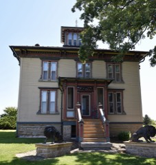
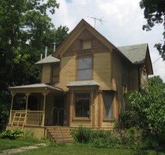
Every property in this county listed on the National Register of Historic Places, with the year it was listed and the federal nomination document.

Photograph PropertyType ListedReference
Amboy Illinois Central Depotbuilding199292001015
Christopher Brookner Housebuilding198484000319
Dixon Downtown Historic Districtdistrict201212000059
Illinois Central Stone Arch Railroad Bridgesstructure198787002048
Lowell Parkdistrict200606000680
Nachusa Housebuilding198383000323
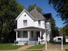
Ronald Reagan's Boyhood Homebuilding198282002580
William H. Van Epps Housebuilding198282002581
Col. Nathan Whitney Housebuilding199090001726
Stephen Wright Housebuilding200505000433

Wildfire, 2008 to 2018

30 fires

Every wildfire the federal occurrence database records inside this county: 30 of them, burning about 252 acres. None started naturally and none was recorded as arson. Each settlement page carries the fires within five miles of it.

Reported cause Fires
Missing data/not specified/undetermined17
Debris and open burning8
Power generation/transmission/distribution2
Smoking1
Equipment and vehicle use1
Other causes1

The five largest, by the area the report gives. None of them was recorded as arson.

DateCause SizeReported by Name on the report
22 April 2014Missing data/not specified/undetermined52 acresIllinois Division of Forestry Resources14-103
13 May 2013Debris and open burning50 acresIllinois Division of Forestry Resources13-95
12 April 2014Missing data/not specified/undetermined50 acresIllinois Division of Forestry Resources14-90
31 October 2008Missing data/not specified/undetermined50 acresIllinois Division of Forestry Resources1684
14 October 2013Debris and open burning10 acresIllinois Division of Forestry Resources13-208
25 October 2013Other causes10 acresIllinois Division of Forestry Resources13-0000221
19 October 2013Power generation/transmission/distribution5.0 acresIllinois Division of Forestry Resources13-223
28 March 2008Missing data/not specified/undetermined4.0 acresIllinois Division of Forestry ResourcesGRUCHALSKI

Every settlement page carries the fires within five miles of it - see the settlement index below.

Storms, 1956 to 2026

60 of 389 shown

The NOAA Storm Events Database holds 389 reports for this county, causing no deaths, 15 injuries and about $3,301,500 in recorded property damage. Each settlement page carries the reports that name it.

Kind of event Reports
Thunderstorm Wind200
Hail115
Tornado38
Flash Flood18
Flood10
Funnel Cloud3
Heavy Rain3
Lightning2

The most serious of them, by death, then injury, then recorded damage. The accounts are quoted exactly as the forecast office filed them.

WhenEvent Place namedHarm What the report says
June 2015Tornado (EF2)Maytown7 hurt, $1,000,000Very significant tree damage occurred with many large trees snapped or uprooted in Woodhaven Lakes Camping Resort. At least one house was pushed off of its foundation. Several trees fell onto recreational vehicles and it was estimated that around 100 of the 300 homes in the area received some degree of damage. One person was taken to the hospital in serious condition, and six others were injured. Peak winds were estimated to be 130 mph. (Tornado 3 of 10).
April 1972Tornado (F2)not stated6 hurt, $250,000no account filed
June 2001Thunderstorm WindCountywide1 hurt, $55,000no account filed
May 1986Tornado (F1)not stated1 hurt, $25,000no account filed
April 2015Tornado (EF1)Franklin Grove$1,000,000This is the beginning of the Rochelle-Fairdale EF-4 tornado. At its strongest, peak winds were estimated to be 200 mph. The tornado touched down just northeast of Franklin Grove. A large sheet metal building on IL-38 collapsed with failure of column anchorage. Several smaller sheet metal buildings were destroyed along E Gurler Road. Peak winds in Lee County were estimated to 110 mph. The tornado continued into Ogle County. (Tornado 2a of 7).
April 1967Tornado (F1)not stated$250,000no account filed
August 1958Tornado (F2)not stated$250,000no account filed
June 2013Thunderstorm WindHarmon$100,000Winds were estimated in excess of 80 mph and upwards of 100 mph for a 13 mile swath. A large outbuilding bolted to its foundation was destroyed. One part of the barn wall was lifted taking a portion of the foundation with it. Numerous large trees were snapped or uprooted, including one that fell onto the front portion of a house. In Walton, four large grain storage bins were destroyed. Also in Walton, a metal outbuilding was destroyed with debris thrown over 200 yards. Shingle damage was also noted on a few homes.
October 2010Tornado (EF1)Ashton$100,000A tornado touched down near Meridian Road southeast of Ashton. The damage path was convergent and narrow. Some of the damage included a couple of outbuildings with poor structural integrity and a few that had their roofs ripped off. The top of a metal silo was 'punched' in and a grain cart was flipped onto its side. In addition to the structural damage, numerous 2x4's were speared into the ground and metal siding was strewn into the fields to the northeast of the farm.
March 2009Thunderstorm WindDixon$30,000A garage was destroyed. A roof was blown off a building and trees were blown down.
April 1991Tornado (F1)not stated$25,000no account filed
May 1988Tornado (F0)not stated$25,000no account filed
April 1967Tornado (F2)not stated$25,000no account filed
September 1959Tornado (F1)not stated$25,000no account filed
June 2010Thunderstorm WindEldena$20,000A roof was blown off a building near Route 52 and Robbins Road. Numerous trees were blown down along Route 30.
June 2009Thunderstorm WindWalton$20,000A barn was destroyed. Trees were also blown down.
July 2004Thunderstorm WindAmboy$20,000A roof was blown off the addition of a house and into a barn. Many rows of corn were knocked down. These events occurred at Bryer Knoll and Rocky Ford.
June 2013Tornado (EF0)Harmon$10,000The tornado mainly traveled over farm fields but did take down numerous utility poles, including a few that were bent sharply to the south, opposite of the storm motion which was to the northeast. A weakly constructed barn was destroyed near the end of the path.
May 2010Flash FloodLincoln Hgts$10,000River Road was closed one half mile east of Galena Avenue with a car stranded in flood water up the bumpers. Six to eight inches of water was reported at the intersection of Route 2 and Willett Avenue. High standing water was reported in many areas in Dixon. Storm total rainfall of 2.73 inches was reported 3 miles north northwest of Dixon.
August 2014Thunderstorm WindAshton$5,000A grain storage bin was damaged by severe winds.
June 2013Thunderstorm WindSublette$5,000Up to 18 inch diameter trees were blown down as well as numerous power lines.
June 2010Thunderstorm WindWest Brooklyn$5,000A large tree was blown down onto an above ground pool. The pool was destroyed.
June 2010Thunderstorm WindSublette$5,000Two trees blew down along U.S. 52. Portable toilets blew over at a park. Part of the roof of a maintenance building blew off.
August 2008Thunderstorm WindCompton$5,000Wind gusts were estimated to 80 mph. Multiple one foot diameter trees were blown down. Shingles were also blown off of houses.
August 2007Thunderstorm WindFranklin Grove$5,000Utility poles blown down.
August 2006LightningDixon$5,000Lightning struck a utility pole, the pole and power lines caught on fire.
August 2006Thunderstorm WindAmboy$5,000Wind gusts were estimated to 70 mph, which blew down trees, tree limbs and power lines.
April 2010Thunderstorm WindFranklin Grove$3,000Two utility poles and a power line were blown down near Daysville and Nalor Roads.
May 1985Tornado (F1)not stated$2,500no account filed
June 1975Tornado (F1)not stated$2,500no account filed
August 1956Tornado (F2)not stated$2,500no account filed
August 2016Flash FloodHarmon$2,000A foot of water moving across Pump Factory Rd between Amboy Rd and McCoy Rd approximately 10 miles south of Dixon.
June 2007Thunderstorm WindDixon$2,000Trees and power lines were blown down.
November 2010Thunderstorm WindDixon$1,000Trees and power lines were blown down.
June 2010Thunderstorm WindAmboy$1,000Trees, tree limbs and power lines were blown down.
June 2010Thunderstorm WindDixon$1,000A tree was blown down across a road. Power lines and a utility pole were also blown down.
June 2009Thunderstorm WindDixon$1,000Trees and power lines were blown down.
June 2007Thunderstorm WindDixon$1,000Tree limbs were blown down onto powerlines.
May 2006Thunderstorm WindDixon$1,000Trees and power lines were blown down.
June 2010Thunderstorm WindDixon$500A street light pole was blown down.
June 1975Tornado (F0)not stated$250no account filed
April 2026Tornado (EF1)Prairieville-An NWS damage survey confirmed that an EF-1 tornado with estimated peak winds of 100 mph began in far northeastern Whiteside County west of Palmyra before moving northeast into Lee County. It tracked for over 6.5 miles before lifting near the town of Woosung. The tornado damaged or destroyed multiple farm outbuildings, downed several trees and power poles, and caused minor damage to a few residences.
April 2026Thunderstorm WindDixon-An emergency manager estimated 60 to 70 mph thunderstorm winds in Dixon.
May 2025Thunderstorm WindKingdom-A photo shared on social media showed several utility poles leaning over Route 2, resulting in power outages.
July 2025Thunderstorm WindWest Brooklyn-Tree limbs up to 6 inches in diameter were blown down near Brooklyn Road and Route 30. Corn was blown over at 35 to 40 degree angles.
July 2025HailFranklin Grove-A Cocorahs obsever in Amboy reported totally destroyed soybean and corn crops six miles north of his location, which would be just south of Interstate 88.
August 2025Flash FloodPaw Paw-A couple of rounds of torrential rainfall brought flash flooding to parts of southeast Lee County. A video shared to social media showed a house in the Paw Paw area surrounded by floodwater with significant flooding in the yard and in nearby fields. Paw Paw Rd was flooded approximately one mile north of Paw Paw. In Compton, water was seen flowing over roads and parking lots. A private weather station in Paw Paw recorded 7.02 of storm total rain, 5.03 of which fell between 3:15 and 5:15 CST. Another private weather station near Dunn Airport northwest of Paw Paw recorded 4.67 of storm total rainfall. The flooding is estimated to have resulted in $5,000 worth of damages, mostly to crops.
February 2024Tornado (EF0)Paw Paw Airport-A brief tornado, which was sighted by storm chasers, touched down along Beemerville Road northeast of Compton and caused roof damage to a farm outbuilding.
February 2024HailSublette-Photo received of golf ball sized hail.
February 2024HailMaytown-A report of 1 hail was relayed via mPING.
March 2024HailDixon-Quarter size hail was reported on the north side of Dixon.
June 2024Thunderstorm WindGrand Detour-A picture was received of a downed tree near Dixon.
July 2024Thunderstorm WindLee-A large tree limb was blown down.
June 2024Heavy RainWalton-Private weather KILDIXON53 recorded 2.71 inches of rain in an hour and a half's time. 2.28 inches of that fell in 40 minutes with over an inch being recorded in a 15 minute span.
March 2023Tornado (EF1)Sublette-This tornado developed just south of the town center of Sublette snapping multiple utility poles as it crossed US Rt. 52. The tornado strengthened as it progressed into the town of West Brooklyn. There, it downed several large trees, folded an approximately 120-foot tall tower, and tore the roof off of a bank in downtown West Brooklyn. A wooden beam from the roof of the bank impaled a nearby garage roof to the north-northeast of the bank. The tornado then lifted north of Shaw Rd just west of Carnahan Rd just over 2 miles northeast of West Brooklyn.
March 2023Thunderstorm WindMaytown-A photo shared by the public via social media shows a barn that had been destroyed. Wind magnitude and time were estimated based on radar.
March 2023Tornado (EF2)Woodhaven Lakes-The tornado touched down in the Woodhaven Lakes campground south of Amboy. There, multiple campers were damaged by the tornado including two that were rolled. Farther along its northeastward track, two trees had fallen onto a home destroying it. The tornado appeared to have reached its maximum intensity with wind speeds estimated at 115 mph shortly after crossing US Hwy 52 where it destroyed a large garage and snapped several trees at their trunks. Several dozen other large trees were snapped and many branches sheared off along its path. Toward the end of its lifespan, the tornado also did minor damage to an outbuilding before lifting near Butler Hill Rd north of West Brooklyn.
April 2023Thunderstorm WindWoodland Shores-A semi truck was blown over on Interstate 88 near Atkinson Road.
April 2023Thunderstorm Wind(C73) Dixon Municipal Airport-A private weather station measured a wind gust to 66 mph with an abrupt wind shift from easterly to westerly, then back to easterly.

Mines and quarries

58 recorded

The Survey's mineral resources record lists 58 workings inside this county. 10 still produce and 48 are closed or unrecorded. Each settlement page carries the workings within five miles of it.

Commodity Workings
Stone, Crushed/Broken53
Sand and Gravel, Construction3
Limestone, General1
Limestone, Dimension1

The least common of them first, because a county's hundredth gravel pit says nothing its first ten did not.

Where SiteCommodity StatusRecorded
Dixon Quarry & Cement PlantLimestone, GeneralProducer
Stoneridge QuarryLimestone, DimensionProducer
Medusa QuarrySand and Gravel, ConstructionPast Producer
Nelson Sand and Gravel PitSand and Gravel, ConstructionPast Producer
Rock River PitSand and Gravel, ConstructionPast Producer
Ashton QuarryStone, Crushed/BrokenProducer
Delhotal Quarry & Portable MillStone, Crushed/BrokenProducer
Dixon QuarryStone, Crushed/BrokenPast Producer
Gerdes QuarryStone, Crushed/BrokenProducer
Hallquist QuarryStone, Crushed/BrokenPast Producer
Inlet QuarryStone, Crushed/BrokenPast Producer
Law QuarryStone, Crushed/BrokenPast Producer
Limestone ProspectStone, Crushed/BrokenOccurrence
Nelson Quarry - Portable Unit #1Stone, Crushed/BrokenProducer
Palmyra QuarryStone, Crushed/BrokenProducer
Robbin's QuarryStone, Crushed/BrokenProducer
Russell/Miller Portable #1 QuarryStone, Crushed/BrokenProducer
Sandusky QuarryStone, Crushed/BrokenPast Producer
Sheely's QuarryStone, Crushed/BrokenProducer
Steder QuarryStone, Crushed/BrokenPast Producer
Steward PitStone, Crushed/BrokenPast Producer
Unnamed Limestone QuarryStone, Crushed/BrokenPast Producer
Unnamed Ls QuarryStone, Crushed/BrokenPast Producer
W. Hemenway QuarryStone, Crushed/BrokenPast Producer

The townships, in 1914

386,911 words

History of Lee County, Illinois devotes a chapter to each township: its boundaries and streams, who settled it and when, the mills, the schools and the churches. All 16 are reproduced here in full. Each row shows the township's own shape and where it lies in the county, drawn from the Census Bureau's boundary. Which settlements belong to which township is computed from that same boundary, not taken from the book.

The county's history books

548,618 words

3 books written about this county, cut here where the book itself is cut, at its printed chapters: 61 chapters in all. Every chapter is public domain, machine-read from the scan and reproduced complete. A chapter already given under one of the county's towns is not repeated in this list.

History of Lee County, Together with Biographical Matter, Statistics, Etc. .. (1881)

ChapterLength
The whole text371,547 words in 24 parts

History of Lee County, Illinois (1914)

War History of Lee County, Illinois, 1917-'18-'19 : a History of the Part Taken by the People of Lee County, Illinois, in the World War, 1917-1918-1919 (1920)

ChapterLength
Chapter 22,545 words
Chapter 42,250 words
Chapter 5652 words
Chapter 71,967 words
Chapter 82,171 words
Chapter 11657 words
Chapter 121,018 words
Chapter 141,146 words
Chapter 156,919 words
Chapter 16763 words
Chapter 171,282 words
Chapter 18465 words
Chapter 19874 words
Chapter 20554 words
Chapter 21502 words
Chapter with an unread heading (no. 16 of those read)1,495 words
Chapter 231,512 words
Chapter 252,845 words
Chapter 26548 words
Chapter 273,444 words
Chapter 286,348 words
Chapter 29414 words
Chapter 30950 words
Chapter 31917 words
Chapter 32677 words
Chapter 331,594 words
Chapter 34429 words
Chapter 35433 words
Chapter 36534 words
Chapter 371,192 words
Chapter 38827 words
Chapter 39653 words
Chapter 40909 words
Chapter 412,393 words
Chapter 42518 words
Chapter 4316,576 words in 2 parts
Chapter 441,163 words

The people it describes

6 named

Everyone History of Lee County, Illinois stops to write about, with the section that describes them. Among them are the men who founded the place and governed the Territory. Each name opens the passage itself, in the words of 1914.

Every populated place in the county

37

Named settlements recorded in the Geographic Names Information System, each with the topographic sheets covering it. Villages, hamlets and abandoned places alike. Each is shown with the nearest named watercourse or landform and the survey quadrangle it falls on.

The vanished settlements of Lee County: the places named above that are no longer on the map.

Provenance

  • Topographic sheets. USGS Historical Topographic Map Collection, county index, measured from the bulk metadata.
  • Fire insurance maps. Library of Congress Sanborn collection, faceted to this county.
  • Photographs. Each place queried individually against the Library of Congress Prints and Photographs search.
  • Wildfire. Short, Karen C. 2022. Spatial wildfire occurrence data for the United States, 1992-2020 [FPA_FOD_20221014]. 6th Edition. Fort Collins, CO: Forest Service Research Data Archive. https://doi.org/10.2737/RDS-2013-0009.6 Collected with United States Government funding and usable without additional permissions or fees.
  • Mines and quarries. USGS Mineral Resources Data System (MRDS) https://mrdata.usgs.gov/mrds/ A work of the United States government, no copyright under 17 U.S.C. 105.
  • Storms. NOAA National Centers for Environmental Information, Storm Events Database https://www.ncei.noaa.gov/stormevents/ A work of the United States government, no copyright under 17 U.S.C. 105. Narratives are quoted verbatim from the National Weather Service report and are not edited or summarised.