BlockBefore

Fish Shanties, Old South Wharf, Nantucket

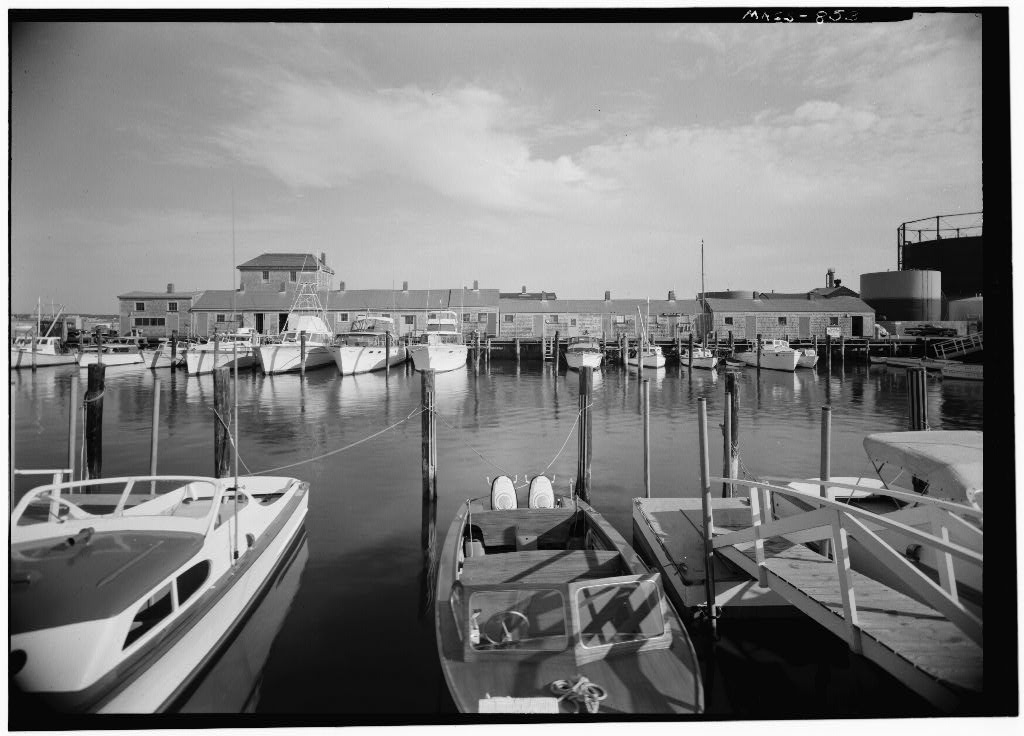
Fish Shanties, Old South Wharf, Nantucket, Nantucket County, MA. Surveyed as HABS MASS,10-NANT,18-, with 1 photograph and a 717-word written history.

From the record

“These small fish and scallop shanties, many of them moved from locations on Washington Street and along the waterfront, are the only remaining wharf structures that resemble those that crowded the wharves in the first half of the nineteenth century.”

Written record, HABS MASS,10-NANT,18- survey. Machine-read text.

surveyed by the federal HABS program as HABS MASS,10-NANT,18- · the record runs 717 words · one of 157 surveyed structures published for this county.

Sources: the survey record at the Library of Congress

Fish Shanties, Old South Wharf, Nantucket, Nantucket County, MA, photograph filed with the federal survey

1 photograph from the federal survey record, Library of Congress.

Significance

568 words

Source document Quoted word for word from HABS MASS,10-NANT,18-. Not written, edited or summarised by this site.

These small fish and scallop shanties, many of them moved from locations on Washington Street and along the waterfront, are the only remaining wharf structures that resemble those that crowded the wharves in the first half of the nineteenth century. PART I HISTORICAL INFORMATION A. Physical History: While the whaling industry had still to reach its climax, in the year the Old South Wharf, later the Island Service Wharf, was started and completed in The Old South Wharf was rebuilt after the decline of the whaling industry into a business wharf. When the United States entered World War I, Mr. Henry W. Lang, who had purchased the wharf in from W. T. Swain and Co., turned the use of it over to the Government for the period of the emergency.

Since then it has continued as a public wharf for commercial purposes. Mr. and Lang established the Island Service Company which supplied fuel, ice and lumber. In the wharf was sold by the Island Service Co. to Sherburne Associates Inc. In Nantucket's Great Fire of Old South Wharf was swept by the flames. The burning oil from storage warehouses rolled and poured into the docks so that the waterfront became a veritable sea of fire, with the New North, Old North, Straight and Old South wharves gradually falling prey to the conflagration. Before the fire Old South Wharf was a hive of industry. Upon or near it were located many shops of the different mechanics then demanded by the general business of the town, especially in connection with the fitting of whaleships for sea.

On the Old South was a pump and block-making business, and close neighbors OLD SOUTH WHARF FISH SHANTIES HABS No. MASS-853 {Page 2) to it were five blacksmith shops; the old rope-walk under the direction of Robert Ratliff, where rope and cordage were spun; over it the sail-loft, where thousands of yards of canvas were fashioned into sails; at the head of the dock was the lumberyard and buildings of Isaiah Robinson and Peleg Macy, besides numerous smaller shops in different trades. All day long coopers, spar- makers, riggers, boat-builders and sailmakers were at work; iron- smiths were forging harpoons, lances and knives; cordage factories were turning out every kind of standing and running rigging, bolt- rope, wormline, marline, spunyarn, whale lines or any other article along those lines.

Practically all of these shops were destroyed in the fire. The rear of these shops was at the water's edge of the lower, inner harbor, overlooking that sheet of water. With the decline of whaling, these became fish houses used in connection with the scalloping and guahauging industry, and many of them were at that time (from on) moved over to the Old South Wharf for that purpose. Other shacks were built between them, accounting for the irregularity of the shapes and sizes of the fish houses. (Abstract, Nantucket Historical Association Records and History of Nantucket by Obed Macy, B. Sources of Information: 1. Old Views: a. Map of the burnt district in the Town of Nantucket resulting from the fire. (This map originally appeared in the New Bedford Mercury.

It was loaned to The Inquirer by Asa Wood, Esq. and reprinted in Editor Cobb's issue of July 24, Now owned by Nantucket Historical Association. b. Old photographs of fish houses in Scrapbooks owned by Miss Grace Brown Gardner (microfilm copy in Nantucket Atheneum). 2.

In context

Nantucket, Massachusetts The place record: every map, photograph and survey of this town.
Nantucket County, Massachusetts 74 topographic sheets across the county.
Library of Congress record The original filed report, and the sheets the survey produced. Those published here appear above.

Also surveyed in Nantucket

24 of 153 records shown

The federal surveyors worked through Nantucket building by building. These are the other structures they measured and filed a report on, longest report first.

SheetStructure SurveyReport
Orange & Union Streets Neighborhood Study, photograph filed with the federal surveyOrange & Union Streets Neighborhood StudyHABS MASS,10-NANT,76-4,507 words
Academy Lane (Houses)HABS MASS,10-NANT,89-4,417 words
Henry Coffin House, photograph filed with the federal surveyHenry Coffin HouseHABS MASS,10-NANT,13-3,317 words
India Street Neighborhood Study, photograph filed with the federal surveyIndia Street Neighborhood StudyHABS MASS,10-NANT,75-3,193 words
Joshua Coffin House, photograph filed with the federal surveyJoshua Coffin HouseHABS MASS,10-NANT,72-2,940 words
William Hadwen House, photograph filed with the federal surveyWilliam Hadwen HouseHABS MASS,10-NANT,48-2,922 words
Nathaniel Macy House, photograph filed with the federal surveyNathaniel Macy HouseHABS MASS,10-NANT,71-2,847 words
Hadwen-Wright House, photograph filed with the federal surveyHadwen-Wright HouseHABS MASS,10-NANT,28-2,837 words
Elihu Coleman House, photograph filed with the federal surveyElihu Coleman HouseHABS MASS,10-NANT,4-2,600 words
Second Congregational Meetinghouse Society Church, photograph filed with the federal surveySecond Congregational Meetinghouse Society ChurchHABS MASS,10-NANT,76S-2,420 words
Swain-Mitchell House, photograph filed with the federal surveySwain-Mitchell HouseHABS MASS,10-NANT,25-2,366 words
Job Macy House, photograph filed with the federal surveyJob Macy HouseHABS MASS,10-NANT,51-2,335 words
Richard Coleman House, photograph filed with the federal surveyRichard Coleman HouseHABS MASS,10-NANT,76G-2,332 words
Pierce, photograph filed with the federal surveyPierceHABS MASS,10-NANT,76U-2,322 words
William Rotch Warehouse, photograph filed with the federal surveyWilliam Rotch WarehouseHABS MASS,10-NANT,15-2,308 words
F. & A.M. Union Lodge, photograph filed with the federal surveyF. & A.M. Union LodgeHABS MASS,10-NANT,23-2,198 words
Solomon & Paul Gardner Houses, photograph filed with the federal surveySolomon & Paul Gardner HousesHABS MASS,10-NANT,76Y-2,195 words
Levi Starbuck House, photograph filed with the federal surveyLevi Starbuck HouseHABS MASS,10-NANT,76K-2,151 words
Coffin SchoolHABS MASS,10-NANT,90-2,135 words
First Congregational Church, photograph filed with the federal surveyFirst Congregational ChurchHABS MASS,10-NANT,26-2,081 words
Worth-Gardner HouseHABS MASS,10-NANT,92-2,070 words
Major Josiah Coffin House, photograph filed with the federal surveyMajor Josiah Coffin HouseHABS MASS,10-NANT,33-2,040 words
Swain-Macy House, photograph filed with the federal surveySwain-Macy HouseHABS MASS,10-NANT,59-2,027 words
Centre Street United Methodist Church, photograph filed with the federal surveyCentre Street United Methodist ChurchHABS MASS,10-NANT,74-2,008 words

Provenance

  • Written history. Quoted verbatim from HABS MASS,10-NANT,18-. United States federal work, no copyright under 17 U.S.C. 105.
  • Text capture. Machine-read from the scanned typescript filed with the survey, so spelling and spacing follow the original page.
  • How this page is made. Documentary passages are quoted from linked records; page labels and counts are clearly marked as presentation or calculations.