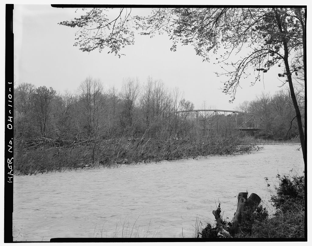
Fred Mitchell Historic Preservation Associates Lenox Place Cincinnati, Ohio Blue Rock Road Bridge HAER NO. OH-113 (page 2) The Blue Rock Road Bridge serves to move local vehicular traffic over the Great Miami River within a northwestern portion of Hamilton County, Ohio. The location has historically served as a river crossing since early settlement and development of the surrounding rural agricultural landscape. The bridge is opposite the unincorporated village of New Baltimore. Settlement into the area, near the present location of the bridge, began as the result of a land auction that was held in April, Tracts of land, upwards of acres, were pur- chased by land speculators for an acre. These were then subdivided into smaller parcels ranging from 40 acres up to 180 acres.
These were sold to individuals and families who were interested in farming in the area. Initial pioneer efforts reguired the clearing of the land and in some situations the draining and filling in of several low areas. Subsistence agriculture was the initial rural activity. Once substantial areas had been cleared or drained, more extensive agriculture was undertaken. By a rural road system had been developed based upon the use of old Indian trails and several new roads that had been built. The area was still evolving and its rural character was being defined. The first small settlement appeared in and was located approximately one mile west of the present bridge location.
The small village of New Haven had evolved as a rural market center to serve the agricultural needs of the surrounding area. One aspect to the character of the immediate environment at the present bridge location was established in Samuel Pottinger owned land adjacent to the Great Miami River which he subdivided into ninety-eight small residential lots. He named the development New Baltimore. Mr. Pottinger had previously established a flour mill and saw mill at this river location. Within a short time several stores, two blacksmith shops, and other activities that addressed the needs of the surrounding rural landscape had been established. New Baltimore functioned more as a small agricultural market center than as a residential village.
The community never fully developed as it had been envisioned. Demand for the mill activities and the growing agricultural landscape reguired that a crossing be constructed that would facilitate travel to and from both sides of the river. Previous- ly, this part had been crossed by fording either on foot, horse, or by wagon. This had not been very reliable since the volume of water and stream velocity fluctuated. By a small pontoon bridge had been constructed. This was easily removed when the Blue Rock Road Bridge HAER No. OH-113 (page 3) river flooded and debris, especially large branches and trees, was carried downstream that could destroy it.
No historical documentation has been found that recorded the construction of the first permanent bridge over the Great Miami River at New Baltimore. A review of the William D. Emerson's Map of Hamilton County, Ohio identified several bridge crossings over the Great Miami River, but there was not one that was at the New Baltimore location. The C. E. Harrison Atlas of Hamilton County, Ohio illustrated what appeared to be a multi- span bridge that crossed the river. The Moessinger and Bertsch Map of Hamilton County, Ohio depicted a substantial bridge at the location. The bridge that the present Blue Rock Road Bridge replaced was a single span metal truss constructed in Its length was four hundred and sixty-five feet.
In March and April of heavy rainfall and subsequent river flooding devastated many parts of Ohio. One result was the loss of many bridges that spanned the Great Miami River as it coursed its way along the western side of Ohio. Within Hamilton County, four bridges were destroyed that crossed this river. One of these was the bridge on Blue Rock Road at New Baltimore. In an effort to ease the immediate traffic situation, a temporary bridge had been erected. The Hamilton County Surveyor, now known as the Engineer, reported to the County Commission an estimate of to replace the steel bridge and to replace the approaches and elevate the existing two abutments.
In an effort to reestab- lish the transportation infrastructure to New Baltimore and the surrounding area the County Commissioners approved a resolution to replace the bridge.
The resolution read as follows: By the Board: Whereas, the highway bridge over the Great Miami River at New Baltimore in Hamilton County and approaches thereto were destroyed by floods occurring in March and April, and Whereas, the County Surveyor has submitted an approxi- mate estimate of the cost of such bridge in the sum of Sixty-four thousand, nine hundred and fourteen and Dollars for the reconstruction of the highway bridge over the Great Miami River at New Baltimore in Hamilton County, and of Twenty-five thousand, two hundred and fifty-four and Dollars for the approaches thereto be and the same are hereby approved, and BE IT FURTHER RESOLVED, that the County Surveyor be and he is hereby directed to prepare Plans and Specifications for such bridge and submit the same to this Board, and that Blue Rock Road Bridge HAER No.
OH-113 (page 4) upon approval by this Board of such Plans and Specifica- tions, bonds of the County shall be issued in the sum of Ninety thousand, one hundred and sixty-nine and Dollars, to secure funds with which to pay the cost of such bridge and approaches under authority of an act of the General Assembly of the State of Ohio, passed April and approved April 12, entitled, "An act to authorize County Commissioners, Township Trustees, Boards of Education, Road Commissioners, Councils of Municipal Corporations, and Boards and Officers thereto temporarily to repair, reconstruct, and replace public property and public ways destroyed or injured by floods occurring in March and April, to authorize County Commissioners and Councils of Municipal Corporations to borrow and expend money for the purpose of cleansing public places and private grounds and buildings and removing there- from any matter deposited therein by said flood which is inimical to public health, safety and convenience; and to exempt proceedings for the permanent repair, reconstruction and replacement of such property and public ways and bonds issued and levies made for such purposes from certain re- quirements and limitations," and BE IT FURTHER RESOLVED, that when said bonds are sold, the Clerk of this Board certify such sale to the County Auditor and that the proceeds of such sale be deposited with the County Treasurer to the credit of the New Baltimore Emergency Bridge and Approach Fund.
(Source: Hamilton County Commissioners Minutes, Book 50, Page May 13, On June 23, the County Commissioners received the following bids for the approaches and raising of the existing abutments at the Blue Rock Road Bridge location: F. W. Folz and Company Van Camp Brothers Delaney and Starr William Harrel and Company Seitz and Hoffmann A. J. Brehm The County Commissioners awarded the contract to the Van Camp Brothers Construction Company. They had the lowest bid. Only two companies bid for the construction of the super- structure. The Massillon Bridge and Structural Company bid was and the Brackett Construction Company offered a bid of Being the lowest bidder, the Brackett Construction Company was awarded the superstructure contract on July, 1, Blue Rock Road Bridge HAER No.
OH-113 (page 5) The Brackett Construction Company was originally founded in in Cincinnati as the F. J. P. Brackett Bridge Company. Mr. Brackett had previously been associated with a Cincinnati firm, the Lomas Forge and Bridge Works, as their Superintendent for bridge projects. By the Brackett Bridge Company was constructing metal truss bridges in Ohio, Indiana, and Kentucky. They were bridge fabricators and purchased their structural steel bridge components from local foundries. By the firm was known as the Brackett Construction Company and had expanded their construction activities to also include the erection of concrete foundations, buildings, and bridge abutments. In the company ceased operation with the retirement of Mr.
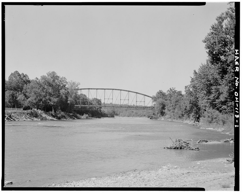
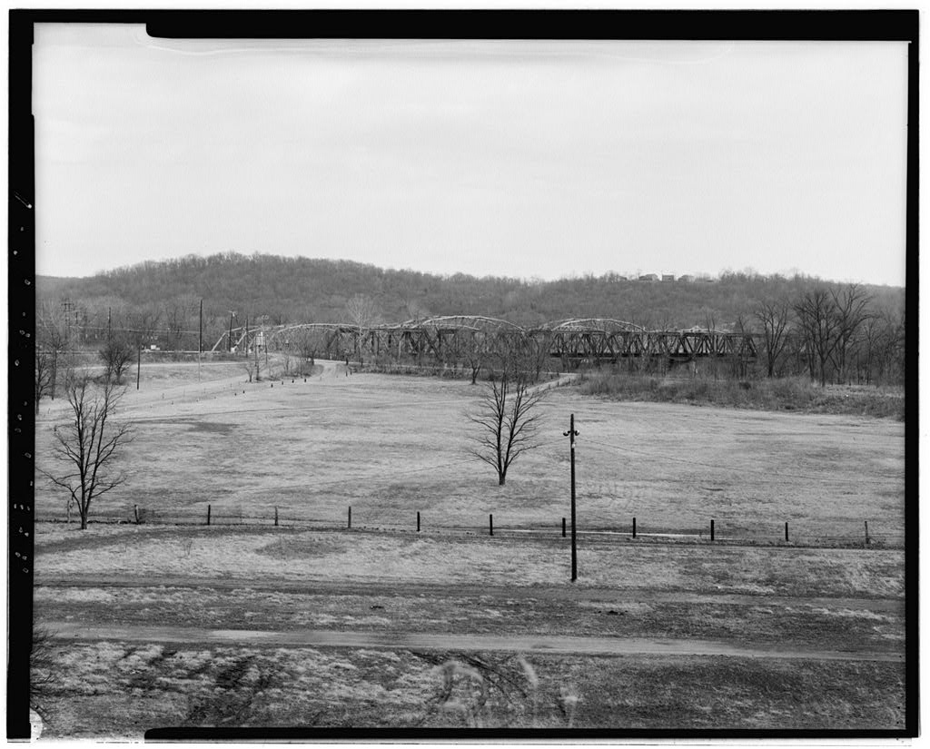
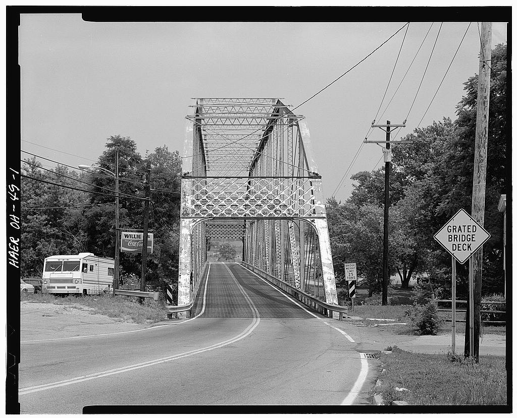
Brackett, who has served at its president since The construction of the Blue Rock Road Bridge consists of a single span riveted superstructure incorporating the details of the Parker Through Truss design. This truss configuration is an adaptation of the Pratt Through Truss design. The Parker truss differs from the Pratt truss in that it incorporates a polygonal top chord. This arched top construction makes the Parker truss stronger when carrying heavy loads or carrying its own weight over a long distance. The Parker truss was also more costly to construct because of the varying length of its vertical members. The overall length of the Blue Rock Road Bridge is four hundred sixty five feet. Its width, across the deck, is twenty- two feet.
The height, extending from the top of the center panel chord down each vertical to its terminus is seventy-one feet. The superstructure is composed of seventeen panels with each extending for a distance of twenty-seven feet and four and one- quarter inches. The span exhibits a configuration composed of two incline end and fifteen interior panels. Incline end posts and polygonal top chords are fabricated from a top cover plate and bottom plate extending two feet and four inches in width and two channel beams two feet in width. All are riveted. Each portal end exhibits a broad multi-lattice sway brace. Bottom chords of six inches in width are composed of paired eye bars that are connected at each vertical.
Verticals are composed of two twelve inch wide channel beams separated by metal lattice. The diagonals are eye bars that are four inches in width and con- nected at the top and bottom chords. Interior struts are compos- ed of lattice bracing two feet sguare and anchored at each top chord. At alternating panels is found interior lattice bracing that extend across the panel and over the deck. Top lateral bracing at the chord webs is composed of metal rods one and one- half inches in diameter. Metal rod sway bracing also is found extending above each of the alternating interior lattice bracing and terminating at the connections of the verticals, top chord, Blue Rock Road Bridge HAER No. OH-113 (page 6) and strut connection. The deck is composed of an open mesh metal grate floor.
On the west side of the deck is found a small pedestrian walkway which also incorporates the same mesh metal grate. The deck and walkway rest atop nine "I" beam stringers that are twelve inches in height. The stringers are supported by large "I" floor beams that are three feet in width and twenty-six feet in length. Bottom lateral bracing is one and one-half inch diameter steel rods. The entire superstructure sits atop four roller assembles and four bearing plates. Large concrete faced abutments, with wing walls, support the superstructure. Located at each end, at an inclined end post, is a small rectangular metal date plate. It reads as follows: COMMISSIONERS Fred. E. Wesselmann Pres. Harry C. Innes Samuel Weil, Jr.
Albert Reinhardt Clerk, Clinton Cowen, Co Surveyor, Brackett construction Co. Builders The superstructure has experienced alterations and replace- ment to portions of its original design and materials. In a new wood deck replaced the original wood deck and new metal grating was added at the pedestrian walkway. New roller assembly and bearing plates replaced the original bearing plates. General repairs were undertaken to strengthen existing connections. By the wood deck had been replaced with a metal grate. Also in that year, several diagonals were replaced and all of the bottom lateral bracing was replaced. Extensive work was under- taken to add a new concrete face to the existing rock faced ashlar abutment and repair the stone of the wing walls.
At present, the superstructure exhibits deterioration to various metal members. Rust and structural decay are evident. The existing Blue Rock Road Bridge has served the rural agricultural landscape for eighty-two years. Today, it exhibits a number of structural deficiencies that are not economical to correct or repair. The superstructure is in need of replacement. Projected future needs for vehicular traffic will place an added strain on the already reduced traffic load carried over the existing structure. A new bridge will provide for safe and efficient vehicular traffic flow. Blue Rock Road Bridge HAER No. OH-113 (page 7) SOURCES OF INFORMATION Emerson, William., Map of Hamilton County, Ohio, C. S. Williams Publishing Company, Ford, Henry and K. B.
Ford, History of Hamilton County, Ohio, Cincinnati, Ohio, Hamilton County Commissioners Minutes: Book 50, Page 121 (May 13, Book 50, Page 122 (May 13, Book 50, Page 295 (June 24, Book 50, Page 316 (June 27, Book 50, Page 437 (July 1, Hamilton County Engineer's Office, Bridge Inspection Report: Blue Rock Bridge, Harrison, C. E., Atlas of Hamilton County, Ohio, C. 0. Titus Publishing Company, Philadelphia, Pa., Merriman, Mansfield and Henry Jacoby, A Text-Book of Roofs and # Bridges, John Wiley and Sons, New York, Moessinger, George and Frederick Bertsch, Map of Hamilton County, Ohio, Cincinnati, Ohio Nelson, S. B., History of Cincinnati and Hamilton County, S. B.
Nelson Publishing Company, Ohio Department of Transportation, The Second Ohio Historic Bridge Inventory, Evaluation and Plan, Note: No original plans or specifications exist for the bridge. The Hamilton County Engineer's Office have drawings prepared by Hanley and Young, structural Engineers which illustrate the work that was undertaken in They also have some drawings prepared by KZF Architects and Engineers which show the work that was done in An aerial photograph from is at the Hamilton County Engineer's Office which shows the Blue Rock Road Bridge in its setting. Blue Rock Road Bridge HAER No. OH-113 (page 8) General Location of Blue Rock Road Bridge within the State of Ohio / ) " ia. I <"Q ic.r P ri t* ST *~1 !* * ji. i PwU t MC JPI-J^1 **4 T"" .
ii D 1- (MA ,1 D Hkkii I JsaH i-,^fl i mi. UMKTOfc \ >= ]n. M d _. K -L. k< * O fc AT CO. j *a- * Blue Rock Road Bridge HAER No. OH-113 (page 9) 0) so da -a 2 S ' & S ist o U o CJ .2 c CQ O C cd 00 oc "5a o c a) O 5 o c T3 VKViaXI ^O v; j Blue Rock Road Bridge HAER No. OH-113 (page 10) I'll/ ,; Location of Blue Rock Road Bridge in Relation to New Baltimore, Ohio 7J >!' H'-ii T!1 ! i r Atlnt | _ ^T 1 . fe w t - " ' A "*' ' * fel r T- 1 i "> i; J:; it k r nt < - 7- r* n ^ J A rw& ' /", " i> Jhr '' i"/ ' /.t.:l.tn,ah.,iniA / ll / > > *< f an/tf .7 .trull III.,!*,-, IHv floo.j* liwm-irt \-X.,ti,ui.i ' ""' "" Ataxv&Mrt,-< ' H. .1- kr^Aimut '** '* Source: C. E- Harrison, Atlas of Hamilton County, Ohio Blue Rock Road Bridge HAER No.
OH-113 (page 11) General Location of Blue Rock Road Bridge J^g and Surrounding Area _/J ' SotJrce: Moessmger mdBertnc\\Map of Hajtiilton County, 0/i/o(1884)
 Block
Block